I guess, it's hard, given the name to apply it on unclassified or path or anything else than track. Other proposals are on their ways to enhance this one Sletuffe16:37, 12 December 2008 (UTC)Reply
"Plattenweg" (Rügen)
The problem is: Highways as on the photo are widely used as interconnections between towns/villages/hamlets. So they are both tertiary roads (function) and tracks (quality). -- Smial09:01, 16 December 2008 (UTC)Reply
tracktype is definitely allowed on any form of highway, although obviously it makes sense more on some (e.g. bridleway) than others (motorway)! There are lots of occurrences of tracktype with footway and bridleway in the database, please don't try and redefine this via the wiki. --Richard10:34, 16 December 2008 (UTC)Reply
No it's not allowed on any form of highway, such as a bridleway or footway. It's for tracks. Tracktype states 2 things. 1. it's a track. 2. the phisical charactoritics of that track. The whole point (which was stated in the original proposal, as well as being accompanied with a diagram) is that it replaces the need for highway=track. If it states thigns about the 'track' we know its a highway=track so that isn't needed. This then frees up the highway key for adding things such as highway=footway with tracktype=grade3. rows and phisical routes can then both be added, rather than the compramise of only putting 'some' data into osm, which in relation to the UK becomes near meaninless. The reason it is still currently used with highway=track is simply because thats what the 2 rendering programs used, not becasue of proposals/discussions/agreements, which is what this should be, and I wish OSM would be all about. pathtype seems to have been used on occasion (looking at tagwatch). Maybe the combining of 2 into 1 is just too hard to grasp in OSM? in which case tracktype may as well be surface=grade1-5 and route=track/path added with it. It would be exactly the same, but just take twice as long to map it..but at least it would stop the same question over and over. Ultimate simplicity rather than any efficiency. Ben00:57, 27 January 2009 (UTC)Reply
If you look at the original Proposal, it is clearly only intended for tracks. I also noted that many renderers and editors will assume that anything with a tracktype is a track and not evaluate the highway tag in this case. This implies that the authors of those tools believe that tracktype occurs only for tracks which is in agreement with the tracktype proposal.
The English version of this page states nothing about highway, but the German version correctly states that it is only for tracks. --Nop10:24, 20 August 2009 (UTC)Reply
32047x tracktype at non-tracks, nearly 4% of tracktypes. At bridleways and paths (a lot of paths might be cycleways using path/designated-modell) it is used in a large number.
For practical mapping tracktype is used in a relevant number for non-tracks, too. This use can't be ignored or called as not allowed. A rough classification of possibly mostly ways outside residential areas seems to be necessary for a lot of mappers. --Mueck 11:45, 8 August 2010 (BST)
In the UK a footway is a right to tread foot..on that way! So a track is a footway. so Tracktype=grade1 highway=footway is normal, and the whole point of this tag. Physically however a footway is not a track. So unless it's a legal right it's a contradiction, and therefore it can be called as not allowed, just as me saying highway=footway footway=no isn't allowed, becuase it's a contradiction. It's not allowed by 'logic'..not by OSM. In most countries footways are just paths. The tag has a different usage, and this isn't an issue, but...tracktype does then clash with it, becuase they are 2 contradicting physical descriptions...and NOT 1 physical and 1 access description as in the UK. Ben 01:18, 5 October 2010 (BST)
Latest comment: 4 years ago4 comments4 people in discussion
Betonstreifen
How do you tag a track where the tracks themselves are built with concrete, tarmac or pavement but the center is of a softer quality? I always tag them as grade1 by the hard material you drive on, but it seems there are other philosophies. --Nop10:20, 20 August 2009 (UTC)Reply
A track was built originally for 4 wheeled vehicles and only where the wheels roll is relevant. Nobody will drive/ride on the center, by essence it was not meant to, somewhat comparable to the side of the track actually, unless exception when the main track is very degraded, like a muddy grade5 track.
So on the case of the photo's concrete lanes with soft center, it's a grade1. But other cases of mixed material are rather grade2 because the wheels will encounter unavoidably and alternately hard/soft material. For example, a track made with grass pavers. --SHARCRASH (talk) 14:51, 6 May 2021 (UTC)Reply
Latest comment: 8 years ago1 comment1 person in discussion
Today a track wirh a surface of 'heavily compacted hardcore' is classified as 'grade1'. Tracks with 'grade2' have a surface of gravel, which can also be heavily compacted. Then a heavily compacted gravel means 'grade1' and a loosely compacted gravel means 'grade2'? I think this difference is very difficult to determine. I suggest to remove the terminus 'heavily compacted hardcore' from 'grade1' and replace it with 'smooth surface' or something like that. --Rudolf 07:03, 12 July 2012 (BST)
Latest comment: 13 years ago4 comments2 people in discussion
Hi, I am interested in some feed back from people who consider they have some "ownership" of the tracktype tag. There has been some discussion in the Australian mailing list about how to deal with 4x4 tracks and even rougher roads. Prompted, to some degree by the excellent routing software now appearing and using OSM. Potential for some nasty situations exist. http://wiki.openstreetmap.org/wiki/Australian_Tagging_Guidelines actually says that tracktype is not suited to Australian conditions, I am not so sure and think it could be easily extended to meet our needs as well.
So, if you have an interest in tracktype, and may well have a watch set on this page, would you support the following -
extending the existing five grades, adding grade6 and grade7 (or better still, 4wd_recommended and 4wd_only) to cover more extreme roads than tracktype currently addresses. At present the preferred way to render such a tag would be by appending, eg, "(4x4 only)" to the road name. This is consistent with how many maps are printed and is familiar to map users.
encouraging render engines to understand that tracktype applies to roads other than highway=track. In Australia, and many other parts of the world, there are quite important roads, connection population centers that need to be marked in a way to warn (eg) visitors to the region that they are not suitable for a conventional car. The highway= tag tells us the purpose of a road, tracktype needs to warn us about its likely condition.
Important ! Encourage people making routing engines to tread very carefully when sending unsuspecting motorists down every road in OSM.
Its worth noting that these matters really do potentially have life threatening aspects. Sadley this has been proven on many occasions and no one wants OSM mentioned in that sort of context.
Sadly, noting no response to this message we have decided on a somewhat simpler and weaker solution. Suggest people mapping 4x4 tracks consider marking them as grade6, grade7 or grade8 (ie 4x4 recommended, 4x4 required, extreme 4x4). Maybe, if this becomes more widely used, we can formalize it. I will make a brief suggestion to that effect on the tracktype page if I hear no objections. --Davo05:02, 29 December 2012 (UTC)Reply
Tracktype has been about the "softness" or "builtness" of the material, not about usability, even if there's a loose correlation between the two - for some road vehicles. Alv09:05, 29 December 2012 (UTC)Reply
Thanks Alv, good to know someone is watching ! The main page says "Tracktype is a measure of how well-maintained a track or other minor road is", thats actually the most important information for someone considering using a particular road or a renderer considering sending some poor unsuspecting soul down it. There would be a pretty tight correlation between 'maintained' and 'usability' IMHO. Not perfect I agree but best we have. Especially important in those parts of the world where there are a lot of roads like we are talking about. --Davo01:09, 2 January 2013 (UTC)Reply
Latest comment: 12 years ago2 comments1 person in discussion
I note someone has removed referance to renders only observing this tag on tracks. The referance used to point out that is not the intention of this tag, it can be applied to any (minor ?) road AND should be so rendered. The fact that the OSM 'official' render does not use this tag on important roads is a serious omission and no amount of editing history will hide that fact. I raise this point because badly rendered maps put lives at risk. I can demonstrate many cases of people dying in the Australian Outback because they were using poor maps. Fortunatly, so far, an OSM map has not been so involved.
This may not be an issue in Western Europe or North America but the world is a bigger place than that. I will put that referance back if no one objects.
The page at one point was edited to say "Almost always unpaved..." for grades 2 to 5 instead of just "Unpaved". I think we should simply use "paved" for grade 1 and "unpaved" for grades 2 to 5 to match usage and simplify the text. --Jeisenbe (talk) 05:18, 7 July 2019 (UTC)Reply
Note that grass paver is considered as paved by some and as unpaved by others. There are also some roads made of fragmented, overgrown and crumbling asphalt, some of them qualifying for grade2 rather than grade1 Mateusz Konieczny (talk) 19:43, 7 July 2019 (UTC)Reply
Dirt roads in arid mountains
Latest comment: 4 years ago3 comments2 people in discussion
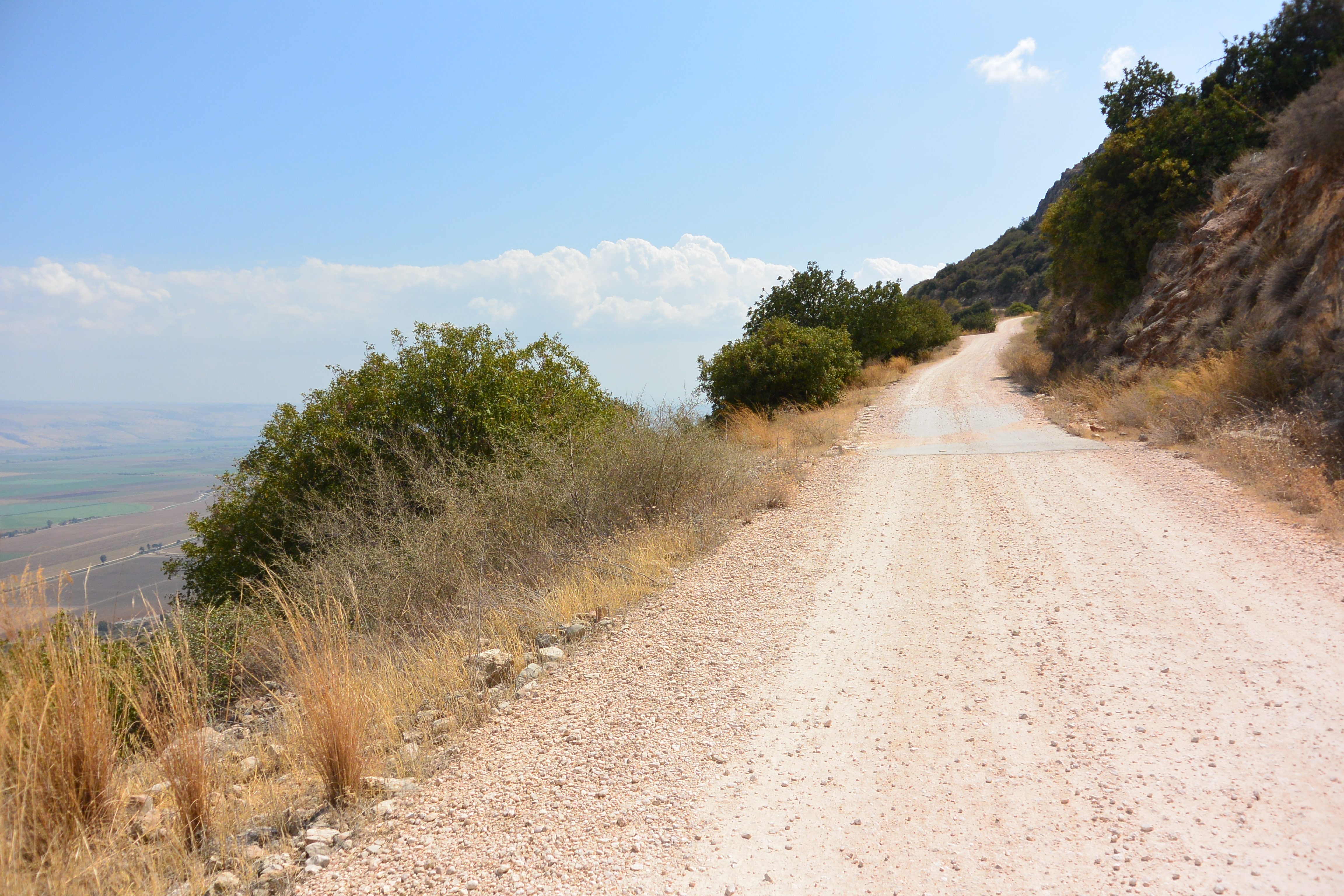
High quality dirt road (Israel)
On Crete tracks are "created" by bulldozers. If they do a good job, they crunch the stones, driving several times for and back. For an impression see here. Some may be usable by normal car, but most only by trucks (pickups, 4WD). The better ones are used several times a day und thus smoothened by use. During rain they may be damaged by erosion and have to be repaired (filled with gravel), the more important ones first of course. I guess its the same everywhere in remote Mediterranean areas.
Currently in OSM all tracktypes from grade2 to grade4 are used for these tracks. From a practical point of view I would use 3 (for the better ones) or 4 (the awful ones, trucks only), but grade2 IMHO is ridiculous. Any opinions? --GerdHH (talk) 09:19, 13 April 2016 (UTC)Reply
Bulldozed gravel roadHere is photo of a rather simple road. After checking my photo collection I must admit that even the most rough gravel roads look a bit smoothened. A video of a machine producing a high-end road, made of rough stones on the base and fine gravel as finish on top, is shown on the website of seppi. Wikipedia describes the process of gravel road construction on their pages Bulldozer (rough, tracktype=grade4?) and Grader (fine, tracktype=grade3?). The rough ones are more erosion prone than the fines ones, but unfortunatley I never took a photo of such damages. IMHO tracktype=grade2 should be reserved for Macadam surfaces only.--GerdHH (talk) 09:08, 29 March 2022 (UTC)Reply
not verifyable
Latest comment: 3 years ago2 comments2 people in discussion
Interesting blog, thank you. Do you have alternatives to offer for the tracktype tag? I have been advised by Graphopper to use it on my edits to Grass Hill as a result of this note: https://www.openstreetmap.org/note/2674954 (Graphopper's comments came in after I closed the note).
I note your saying that usefulness is not a suitable criterion for information in the map. I hear you. At the same time there is clearly a huge need for the information that tracktype attempts to convey, because routing is so big a part of how the database is now used (and just the sort of use that was intended ab initio, I imagine).
I assume the solution is more fine-grained tags for physical properties? Ideas I've had: "surface=rutted", "friability=high", etc.
Latest comment: 4 months ago8 comments4 people in discussion
The opening sentence currently states that Tracktype is a measure of how well-maintained a track or other road is, particularly regarding surface firmness. The maintenance aspect is mentioned for grade2 (heavily degraded and crumbled roads) and grade5 (unimproved track), in both cases as a secondary aspect after surface firmness. Recent forum polls amid extensive discussions suggest that surface firmness is the main aspect:
Poll 2 (21 voters): mostly firmness outpolled mostly state of development 2:1, but the main outcome was it's complicated
Poll 3 (9 voters): 66% said map editor presets refer to firmness
So, I propose reordering the significance of these correlated aspects by rewriting the opening sentence like this: Tracktype is mainly a measure of surface firmness of a track or other road, which in many regions also reflects how well-maintained it is. --Fernando Trebien (talk) 12:39, 19 February 2026 (UTC)Reply
We already have a key for surface=*, which implies a corresponding firmness. Does it make sense to have two tags that both primarily describe the surface and its firmness, but no longer have a tag that primarily describes the degree of maintenance? --Hufkratzer (talk) 19:45, 19 February 2026 (UTC)Reply
I'm worried if we accept that 76 voters can redefine (even slightly) a tag definition used 10 Million times on the course of 20 years. However bad or unprecise this tag might be, it has been used and known by this definition. I'd suggest those who really want to tag tracks's firmness to define and use a new firmess=whatever tag. sly (talk) 13:45, 20 February 2026 (UTC)Reply
In fact, the article remained essentially stable for over 10 years, and about 2/3 of the uses of tracktype=* were mapped during that period. However, the article does not define what "maintenance" is, and the participants in the linked forum threads also offered no explanation of what it means to them. What indicators are mappers using to assess it? If we have 5 levels of maintenance, what is "high" maintenance? What is "medium-high" maintenance? What is "medium-low" maintenance? These are not defined in the article nor in the discussions. On the other hand, throughout this period, "surface firmness" has been better defined, exemplified, and explained in terms of material composition. --Fernando Trebien (talk) 01:36, 23 February 2026 (UTC)Reply
5 years ago on Tag:highway=track the description for tracktype was changed from "can be used for the maintenance intensity and surface firmness" to "specifies roadway firmness" (based on a mailing list discussion that did not discuss tracktype=*, maybe @Ezekielf: wants to explain it). Therefore currently the wiki is contradictory and confusing and I appreciate that you are trying to make it less contradictory and confusing again. OTOH I often found surface=* more complicated to apply than tracktype=* because tracks often have mixed surfaces; it is also less used in cobination with track, see taginfo. If you redefine tracktype to firmness, then I fear that it will become at least as difficult to apply as surface=*. --Hufkratzer (talk) 15:03, 1 March 2026 (UTC)Reply
Thank you for pointing this out, @Hufkratzer:. I have changed the description of tracktype on the highway=track page to match the infobox on the tracktype page: https://wiki.openstreetmap.org/w/index.php?title=Tag%3Ahighway%3Dtrack&diff=2960156&oldid=2960148. I'm disappointed in myself for having made this error five years ago. The reason it happened is because at the time there was significant controversy around all highway=track being described as "unmaintained". A major goal of that page rewrite was to remove mentions of maintenance because a road's level of maintenance is not a good reason to choose highway=track as the primary tag. On this line, removing the mention of maintenance left tracktype described only as specifying firmness. I should have foreseen the misunderstanding this could cause. It was an unintentional oversight in a much larger rewrite of the whole page. --Ezekielf (talk) 15:35, 3 March 2026 (UTC)Reply
Does “firmness” refer to the surface layer or the road structure?
Latest comment: 4 months ago2 comments2 people in discussion
It is unclear whether the grading refers only to the surface material or to the overall load-bearing structure of the road. --julcnx (talk) 10:36, 9 March 2026 (UTC)Reply
Firmness refers primarily to the observable surface layer: the material vehicles actually contact. This is what mappers can verify through direct observation or probing during survey. Subsurface load-bearing structure, while it may influence surface firmness, is typically invisible and therefore not practical for mappers to assess consistently. --Fernando Trebien (talk) 14:57, 9 March 2026 (UTC)Reply
How are maintenance and firmness related in the grading scheme?
Latest comment: 4 months ago2 comments2 people in discussion
The introduction links tracktype to maintenance but the value definitions focus on material composition and firmness, without explaining how maintenance affects the grade. --julcnx (talk) 10:36, 9 March 2026 (UTC)Reply
Maintenance should be either defined (because it never was) or removed from the article. At best, it can currently only be understood as a factor that often correlates with firmness. However, naturally firm soils (rocky, sandy, arid climates) can offer firmness with minimal or no maintenance.--Fernando Trebien (talk) 14:57, 9 March 2026 (UTC)Reply
How should grade3, grade4, and grade5 be distinguished in the field?
Latest comment: 4 months ago1 comment1 person in discussion
The descriptions (“even mixture”, “mostly soft”, “soft”) are vague and lack observable field criteria, making consistent mapping difficult. --julcnx (talk) 10:36, 9 March 2026 (UTC)Reply
What observable indicators should mappers use to determine a grade?
Latest comment: 4 months ago1 comment1 person in discussion
The page provides no field indicators such as compaction, drainage, rut depth, or grading that would help distinguish between grades. --julcnx (talk) 10:36, 9 March 2026 (UTC)Reply
Do wheel tracks or the entire road surface determine the grade?
Latest comment: 4 months ago2 comments2 people in discussion
The example images emphasize wheel tracks and center strips, but the text does not explain whether grading should consider only the wheel contact surfaces or the full road width. --julcnx (talk) 10:36, 9 March 2026 (UTC)Reply
Latest comment: 4 months ago1 comment1 person in discussion
The illustrations show grass or soil center strips as a visual difference between grades, but this feature is not discussed in the written definitions. --julcnx (talk) 10:36, 9 March 2026 (UTC)Reply
When does a degraded paved road stop being grade1?
Latest comment: 4 months ago3 comments2 people in discussion
The wiki says grade2 may apply to degraded paved roads, but it does not explain when a paved surface should no longer be considered grade1. --julcnx (talk) 10:36, 9 March 2026 (UTC)Reply
When it is no longer possible to travel continuously over a paved surface, even with minor maneuvering around exposed underlying base material (gravel, dirt). --Fernando Trebien (talk) 14:57, 9 March 2026 (UTC)Reply
One thing that still seems inconsistent is how degradation is treated. A paved road that deteriorates may drop from grade1 to grade2, even though the surface material is still asphalt. But similar degradation on an unpaved track (erosion, deep ruts, poor compaction) is usually considered a smoothness issue rather than a change in tracktype. In practice both situations affect firmness and usability. It would be useful to clarify why degradation affects tracktype for paved surfaces but not for unpaved ones. --julcnx (talk) 06:17, 10 March 2026 (UTC)Reply
How should seasonal variation affect grading?
Latest comment: 15 days ago4 comments3 people in discussion
In many regions track firmness changes significantly between dry and wet seasons, but the wiki does not clarify whether grading should represent typical, best, or worst conditions. --julcnx (talk) 10:36, 9 March 2026 (UTC)Reply
I would prefer a static map to represent typical conditions under normal climatic conditions and use an extra tag for the worst conditions (e.g. tracktype:seasonal=* for seasonal variation, tracktype:conditional=... @ wet for conditions during/after rain). If there is no clearly dominant condition (no condition applying to more than 60% of the time), I would lean toward representing a worse condition with the main tag. A cleverly designed app can display the combination of those tags together, providing the map user with both warnings and realistic expectations. Note that surface=* often implies changes after rain or when frozen, without need to explicitly restate the typical variation under different conditions, and as such it is a richer tag than tracktype=*. For example, for surface=clay, it shouldn't be necessary to add tracktype:conditional=grade5 @ wet as this is already known for most clay soils. --Fernando Trebien (talk) 14:57, 9 March 2026 (UTC)Reply
surface=laterite is a concrete case this maps onto directly. Laterite tracks cycle seasonally rather than degrading once: the same road can be grade2 (brick-hard) in dry season and grade5 (impassable mud) a few weeks into wet season, then back again, every year, indefinitely. Neither season is more "typical" than the other since both recur predictably every year. This fits the tracktype=* / tracktype:seasonal=* split above rather well: main tag for the most-common condition, tracktype:conditional=grade5 @ wet for the wet-season state. The accepted surface=laterite tagging guidance already leans this way as a stopgap, default to grade3, restrict grade2 to roads demonstrably firm year-round, but it stops short of actually recommending tracktype:conditional=*, since that subtag is still rare enough that no tool would pick it up yet. julcnx (talk) 16:42, 15 July 2026 (UTC)Reply
Worth noting on the tool side too: some routing engines currently exclude highway=track + grade3 entirely from car routing, while others only apply a heavy cost penalty instead of a hard exclusion. A laterite road surveyed in different seasons could sit on either side of that cutoff, with nothing in the data flagging that the grade is seasonal. Feels like a real argument for pushing tracktype:seasonal=*/tracktype:conditional=* from a rarely-used escape hatch to an actual recommendation. julcnx (talk) 16:43, 15 July 2026 (UTC)Reply
How does `tracktype=*` relate to `smoothness=*`?
Latest comment: 3 months ago6 comments3 people in discussion
Both tags provide information about road condition and usability for vehicles, but their relationship and intended separation are not clearly explained. --julcnx (talk) 10:36, 9 March 2026 (UTC)Reply
These tags capture different dimensions. tracktype=* has been described for many years, in the wiki and in map editor presets (reaching more new and casual mappers), as surface firmness and composition, implying the likelihood of sinking, getting stuck, or losing traction. Firmness in this case refers to the surface's shear strength and bearing capacity (see Soil mechanics). smoothness=* is mainly for surface shape, bumps, ruts, and minor obstacles that affect comfort, stability and require vehicle clearance. A track can be firm but rough (rock outcrop: tracktype=grade1, smoothness=horrible) or soft but smooth (fine sand: tracktype=grade5, smoothness=good in the sense of no obstacles, though difficult to traverse). Both tags provide valuable routing information. Certain surface=* types tend to deform easily and certain other surfaces have the opposite tendency, so the two characteristics are correlated but still conceptually orthogonal. Hence, surface=* alone adds more information than either tracktype=* or smoothness=* and often more than the two combined. --Fernando Trebien (talk) 14:57, 9 March 2026 (UTC)Reply
The boundary between grade1 and grade2 for degraded paved tracks is not defined. The best way to improve verifiability here would be to provide a set of example photos illustrating the transition, similar to the examples gallery of smoothness. The combination grade1 + smoothness=horrible is theoretically possible but almost non-existent according to the tracktype-smoothness correlation. Most cases appear to result from one tag being updated without the other being revised due to oversight, uncertainty or indifference. I can imagine this combination being used briefly after a natural disaster like a landslide, a flood or an earthquake. --Fernando Trebien (talk) 20:50, 23 April 2026 (UTC)Reply
As shown in the tracktype-surface correlation, surfaces such as rock, wood, and grass_paver do occur with grade1. It is also not uncommon to find dirt or sand paired with grade2, which the current definition does not prohibit, so it depends on which criteria one applies (eg. this might be a track thinly covered in sand with a strong subbase if the mapper prioritized the construction criterion). Many of the (extensive and exhausting) recent discussions were trying to reach a consensus on how to prioritize these criteria. --Fernando Trebien (talk) 20:50, 23 April 2026 (UTC)Reply
Why do the example images show rutting and vegetation differences not mentioned in the text?
Latest comment: 4 months ago2 comments2 people in discussion
The illustrations imply differences based on rut depth, vegetation, and maintenance, but these factors are not part of the written grade definitions. --julcnx (talk) 10:36, 9 March 2026 (UTC)Reply
Maintenance is still not defined, so I don't know what exactly you are seeing in the images. Could it be related to keeping vegetation to a minimum? Rut depth illustrates a consequence of surface type and firmness and might me mentioned as such. --Fernando Trebien (talk) 14:57, 9 March 2026 (UTC)Reply
What dimension are the grades intended to represent?
Latest comment: 4 months ago4 comments2 people in discussion
The page mixes maintenance, firmness, material composition, and road quality/usability without clearly defining which dimension the grading scheme is meant to represent. --julcnx (talk) 10:36, 9 March 2026 (UTC)Reply
The descriptions of values have been, for a long time, clearly focused mainly on surface=* type (material composition and structure) and firmness. Both partially represent usability. --Fernando Trebien (talk) 14:57, 9 March 2026 (UTC)Reply
Thanks, that helps clarify the intent. However, if firmness mostly derives from the surface material and structure, it makes the statement in the article a bit unclear: “the same surface material can exhibit various degrees of firmness”. If that is the case, it would probably help the wiki to explain what observable factors cause those differences in firmness in the field (e.g. compaction, grading, traffic wear, etc.), otherwise it remains difficult for mappers to consistently distinguish grades. --julcnx (talk) 06:14, 10 March 2026 (UTC)Reply
The article should certainly mention objective criteria on how to assess firmness more consistently, preferably with example photos. Some were mentioned previously, like tire marks, ruts and vegetation. Perhaps they were silently removed because they were not well explained and caused more confusion than helped. For example, a track might have overgrown vegetation one day, but a few days later it undergoes maintenance and becomes clear, or perhaps tire tracks seen one day are erased by rain overnight. Those conducting surveys will reach very different conclusions at different times if the article does not explain how to carefully interpret these cues. --Fernando Trebien (talk) 11:57, 10 March 2026 (UTC)Reply
Should the wiki provide guidance on how data consumers should interpret each grade?
Latest comment: 4 months ago2 comments2 people in discussion
The wiki describes tracktype as useful for "road quality" but gives no guidance on how routing engines, renderers, or navigation applications should treat each grade — for example, at which grade a standard car router should avoid a track, or how grades should influence rendering. Without this, data consumers must interpret the scale independently, leading to inconsistent behaviour across applications. --julcnx (talk) 10:36, 9 March 2026 (UTC)Reply
Definitely. Here is a summary of what many of them do already (there's a mention of how BRouter operates further down that thread). I think the wiki should document observed practices and suggest that:
grade1-grade2: Generally passable by normal passenger vehicles
grade3: May require caution or robust vehicle depending on surface=* type
grade4-grade5: High clearance or off-road capability (e.g. 4wd_only=*) often needed
Why does grade1 effectively correspond to paved roads?
Latest comment: 4 months ago2 comments2 people in discussion
The wiki describes tracktype as a measure of firmness, yet in practice grade1 appears to apply almost exclusively to paved tracks. It is unclear why a very firm unpaved track (for example with surface=compacted or well-compacted gravel) could not also qualify as grade1, especially if the scale is meant to describe firmness rather than material. In both cases the road may be easily passable by standard vehicles, with surface=* providing the material detail. --julcnx (talk) 06:21, 10 March 2026 (UTC)Reply
Latest comment: 3 months ago2 comments1 person in discussion
While tracktype=* is widely used and provides a coarse indication of some sort of track quality, multiple long-standing discussions spanning many years suggest that tracktype=* is difficult to verify consistently due to vague definitions, conflicting criteria, and reliance on non-observable properties.
Some think the assessment is affected by unpredictable maintenance/repair cycles. [9]
Limited observability
Some think the visual assessment of load-bearing capacity is impossible. [10] Load-bearing capacity as a criterion was not part of the original proposal and was introduced into the German wiki informally. [11]
Some argue that the substructure cannot be directly observed. [12], [13], [14] Others argue it is implied by some observable cues like embankments, roadside ditches and camber. [15]
Some think development cannot be reliably assessed. [16]
Conflicting criteria
A maintainer of the default OSM Carto style characterized the definition of tag as not consistent and non-verifiable in practice.
Mappers are divided on what is the main criterion: firmness or construction/quality. [17], [18], [19], [20], [21], [22], [23]
The natural bedrock case is ambiguous. Some lean toward the firmness criterion. [24], [25], [26] Others lean towards a construction/improvement criterion. [27]
Some think pedestrians, cyclists and car drivers would assess the same track differently. [28], [29]
Some say the tag does not depend on specific vehicles or transport modes. [30] Others seem to think it does. [31], [32], [33], [34]
Contrary to what the grade descriptions would suggest, the photo for grade3 has unexpected potholes while grade4 does not, and some think there is no apparent difference in the amount of work invested in building either. [35]
There have been different assessments on-site by different mappers. [82]
Unclear validity of tag combinations
JOSM and StreetComplete use different thresholds for acceptable surface/tracktype combinations. [83]
Some mappers remove tracktype=* when retagging highway=track to other highway=* types, considering it track-specific. The origin of tracktype on non-tracks is often unclear: some instances reflect intentional use, others are artifacts of uncoordinated retagging. [84], [85], [86]
The creator of StreetComplete said tag value definitions are vague, especially the description of grade2, making it difficult to reliably identify contradictions with surface=*.
Whether grade1 is appropriate with surface=compacted varies by local mapping practice. [87]
Some mappers disagree on whether grade2 is appropriate with surface=sand. [88], [89]
Some routing systems don't route cars over grade3 or worse, but others do. [90]
Despite these many discussions, no clear consensus has emerged on several core aspects of the tag's definition, and the issues above remain unresolved. As a result, the reliability of the tag for applications is limited, as assessments may not be consistently reproducible between mappers. Fernando Trebien (talk) 04:36, 4 April 2026 (UTC)Reply
Latest comment: 3 months ago1 comment1 person in discussion
I've checked how some tracks over natural bedrock are mapped. Most of the ones I found, listed below (all in the US, it's apparently hard to find them in other countries), are mapped as grade2 or grade3. Many alternate between hard continuous rock sections and sections that look more like dirt roads (sometimes pure dirt, sometimes with smaller rocks). Most are also tagged smoothness=horrible, which is probably correct (it matches the descriptions, but some sections look much more difficult than the illustrative photo used for very_horrible); to me this shows that rendering tracks without changing its style according to smoothness=* can mislead map users.


.jpg)
 Soil mechanics).