Template:Bs:Map Features:properties
Jump to navigation
Jump to search
Template for the Properties table in the Map Features page. Use the default English text or use the template arguments for your translations
==Usage==
All parameters are optional. By default, text is in English.
English writers shall write their comments in the template itself (avoiding double edition).
Other languages are translated in template arguments, not in the template itself.
== section header ==
|name=        (section header line)
|description= (displayed before or after the table; optional)

== One key/value row ==
|bridge:key=   |bridge:value=   |bridge:desc=   |bridge:render=   bridge:photo=
Karakteristike
Properties are those keys and tags which, in contrast to top-level tags, are used to give additional information of a general nature about another element.
| Key/Ključ | Value/Vrijednost | Element | Komentar | Slika |
|---|---|---|---|---|
| area | yes | Znači da je objekat koji je inače linija sada područje (tj. površina). Ovo ne trebate dodavati značajkama koje su same po sebi definirane kao područje. Npr. korisno za trgove - okružite cestama i dodate area=yes. | 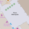 | |
| brand | user defined | Brand of the feature. |  | |
| bridge | yes / aqueduct / viaduct / cantilever / movable / covered / … | Most, koristi se sa oznakom layer=*. Vrijednost bridge=yes je globalna, a možete precizirati vijatudukt, aquadukt i sl.
|
 | |
| capacity | amount | Used for specifying capacity of a facility. |  | |
| charge | amount | Used for specifying how much is charged for use/access to a facility. See toll=* or fee=*.
|
 | |
| clothes | see key's page | Tagged on shops and other features to denote if they sell clothes or not and what type of clothes they sell. |  | |
| covered | yes | Used to denote that a node, way or area is covered by another entity (or in some cases the ground), when the use of layers is inappropriate, or additional clarification is needed. |  | |
| crossing | no / traffic_signals / uncontrolled / island / unmarked | Pješački ili drugi prelaz preko ceste |  | |
| crossing:island | yes / no | Specifies whether a pedestrian crossing has a refuge island |  | |
| cutting | yes / left / right | Usijek u kojem je cesta ili pruga. Najčešće u brdovitim krajevima. Source |  | |
| disused | yes | Za značajke koje su korisne za navigaciju, a koje su nekorištene ili napuštene. | 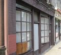 | |
| drinking_water | yes / no | Describes whether a drinking water is available |  | |
| drive_through | yes / no | Used to indicate if a pharmacy, bank, atm, or fast_food, or post_box offers drive_thru service. drive_through=* is different than drive_in=*
|
 | |
| drive_in | yes / no | Used to indicate if a cinema is a drive-in cinema or a restaurant offers drive-in service. drive_in=* is different than drive_through=*
|
 | |
| electrified | contact_line / rail | Indicates infrastructure to supply vehicles with electricity on rail tracks |  | |
| ele | Number | Nadmorska visina (mean sea level) u metrima, bazirano na geoid model EGM 96 koji se koristi sa WGS 84 (GPS). (vidi i Altitude) | 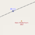 | |
| embankment | yes | Nasip, izdignuta cesta, pruga na nasipu, obično preko niskih ili poplavnih područja. Source | 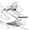 | |
| end_date | Date | Datum kada je maknut |  | |
| energy_class [en] | code | An energy class of the feature |  | |
| est_width | Number | Gruba procjena širine puta u metrima |  | |
| fee | yes / no | Used for specifying whether fee is charged for use/access to a facility. See also toll=*.
|
 | |
| fire_object:type | poo / szo | Potentially dangerous and socially significant objects | ||
| fire_operator | Name | Fire station, which serves the object | ||
| fire_rank | 1bis / 2 to 5 | Rank fire, defined for a particular object | ||
| frequency | Number | Frequency in Hz |  | |
| gutter [en] | yes/no | Presence of the gutter |  | |
| hazard | see hazard | Indicates of the hazards. |  | |
| hot_water | yes / no | Describes whether a hot water is available | ||
| inscription | User Defined | The full text of inscriptions, which can be found on buildings, memorials and other objects. |  | |
| internet_access | yes / wired / wlan / terminal / no | This tag is for indication that a map entity such as a building, a shop, restaurant, etc. offers internet access to the public, either as a paid service or even for free. |  | |
| layer | -5 to 5 | Ova brojčana oznaka koristi se da bi odredili nivo nekog objekta. 0: površina zemlje; -1:ispod površine zemlje; 1 (not +1):iznad površine zemlje Ovo se koristi za stvarno fizičko stanje (npr. kod petlji - viadukti, preko ceste), a ne da bi utjecali na redoslijed renderiranja. |
 | |
| leaf_cycle | evergreen / deciduous / semi_evergreen / semi_deciduous / mixed | Describes the phenology of leaves |  | |
| leaf_type | broadleaved / needleleaved / mixed / leafless | Describes the type of leaves |  | |
| location | underground / overground / underwater / roof / indoor | Location |  | |
| narrow | yes | Relativna indikacija da put (vodeni tok, cesta, biciklistička staza) postaje uži/a. |  | |
| nudism | yes / obligatory / designated / no / customary / permissive | Indicates if the described object provides the possibility of nudism |  | |
| opening_hours | 24/7 or mo md hh:mm-hh:mm. (read described syntax) | Radno vrijeme - opisuje kada je nešto otvoreno. |  | |
| opening_hours:drive_through | 24/7 or mo md hh:mm-hh:mm. (read described syntax) | opening_hours describes when something is open for drive-through services. |  | |
| operator | korisnički definirano | Oznaka operatora može biti korištena da imenuje kompaniju ili korporaciju koja je odgovorna za određeni objekat ili koja operira njime. | ||
| power_supply | yes / no | Describes whether a power supply is available |  | |
| produce | User Defined | Describes a feature's agricultural output produced though a natural process of growing or breeding. |  | |
| rental | see key's page | Tagged on shops and other features to denote if they rent something or not and what they rent. |  | |
| sauna | yes / no | Describes whether a sauna is available |  | |
| service_times | see opening_hours | Times of service of a given feature e.g. church service |  | |
| shower | yes / no | Describes whether a shower is available |  | |
| sport | soccer / tennis / basketball / baseball / multi / ... | Describes which sports are placed on a facility such as a pitch or stadium. |  | |
| start_date | Date | Datum kreiranja objekta |  | |
| tactile_paving | yes /no | Indicate if a specific place can be detected or followed with a blindman's stick. |  | |
| tidal | yes | Area is flooded by the tide |  | |
| toilets | yes / no | Describes whether a toilets is available |  | |
| topless | yes / no | Indicates if the described object provides the possibility of female topless practice |  | |
| tunnel | yes | Tunel, koristiti s oznakom layer=*.
|
 | |
| toilets:wheelchair | yes / no | States if a location has a wheelchair accessible toilet or not. |  | |
| wheelchair | yes / no / limited | Indicira da posebno mjesto može nbiti korišteno sa invalidskim kolicima. |  | |
| width | Number | Širina puta u metrima |  | |
Odnosi se na landuse=forest i na natural=wood precizirajući vrstu drveća koje se nalazi unutar svake upotrebe zemljišta. Najviše ima smisla kada se upotrebljava na područja.
|
 |
This table is a wiki template with a default description in English. Editable here.
Template uređujte na: http://wiki.openstreetmap.org/w/index.php?title=Template:BS:Map_Features:properties