Virginia/Highway classification

This page is about the highway classification standards of Virginia. Throughout the page, links to Wikipedia have been provided for further explanations of highway features along with relevant images for reference.
Virginia has a very well-established highway system, and understanding it can be confusing. There are nearly 60,000 miles of Virginia Department of Transportation (VDOT)-maintained highways in the state altogether.[1] This page is intended to be easy for newer OpenStreetMap users to understand, and those who may not have as much experience with the state highway network.
Basic explainations
Highways in Virginia can be divided into five categories:
- Interstate Highways are the most important highway network in the state of Virginia and the contiguous United States. These are tagged with
highway=motorway. Business routes are tagged with eitherhighway=secondary,highway=primary, or sometimeshighway=trunkandhighway=motorwaydepending on the importance and structure. - U.S. Routes are the second-most important highway network in Virginia and the U.S. These can be tagged with
highway=primaryfor general, perhaps less important routes,highway=trunkfor long-distance travel routes or routes that connect important population centers, andhighway=motorwayfor freeways. Business routes are tagged with eitherhighway=secondary,highway=primary, or sometimeshighway=trunkandhighway=motorwaydepending on the importance and structure. - Primary State Highways (VA 000) are the main state highways of Virginia and are all highways numbered 1 through 599. The lowest classification that these highways should be tagged with is
highway=secondary, for if it does not act as a priority route or doe not connect any population centers aside from small communities.highway=primaryis for major thoroughfares and routes that connect villages and small towns,highway=trunkis for highly important routes that connect large towns and cities, andhighway=motorwayis for freeways. However, there are some examples of state highways with lower numbers, which are normally reserved for primary highways. These are located within Virginia state institutions and should be tagged withhighway=tertiaryor lower. Primary state highways that aren't on institutional properties but are very insignicant (no connection to another major highway, no outlet, etc) should be tertiary. There are also two primary state highways signed with numbers about 599; VA 785 and VA 895. These are signed for the Interstate highways that will follow their routes in the future. - Secondary State Highways (SR 00000) are the second-level state highways of Virginia and are numbered 600 and up. These can be tagged with
highway=residentialandhighway=unclassifiedfor regular residential streets, minor frontage roads, dead-end roads, etc.;highway=tertiaryfor general through roads that can get drivers from one point to another;highway=secondaryfor through roads that are more important and may have better access to higher-level highways as well as more lightly-travelled rural highways that still connect small towns; andhighway=primaryfor longer, major thoroughfares that, while not as important as a primary state highway, are still quite important and usually pass through town centers and/or connect multiple major highways, and very rarelyhighway=trunkcan be used as it would with any other highway. - Unnumbered roads refer to any highway that is not signed or lacks a proper road number.. The majority of unnumbered roads are in Virginia's independent cities as in general, these are city-maintained roadways and exist outside the state highway system. The other case of unnumbered roads are extremely minor rural and private ways which are not maintained by VDOT. These can be tagged with any of the available tags, depending on what the road is. If it is a freeway, use
highway=motorway; if it is a minor street, usehighway=residentialorhighway=unclassified; if it is an unmaintained unpaved backroad, usehighway=track; if it is an important and heavily-traveled thoroughfare, usehighway=primary, etc.
Specific uses of tags
Motorway

The tag highway=motorway is used on all Interstate Highways in Virginia, as well as any other highways and sections of highways that have a minimum speed of 45 MPH, are divided, and are fully grade separated (with some minor exceptions explained here below), including U.S. Routes, Virginia State Routes, and unnumbered or differently-signed controlled-access highways (freeways). Typically in the United States, highway=motorway is applied to highways or segments of highways that have at least two consistent interchanges with no major interruptions between, or in rarer cases, single-interchange segments that still have a reasonable length and multiple overpasses/underpasses among other types of grade separations.
E-ZPass high-occupancy toll lanes (HOT lanes) and other separate high-occupancy vehicle lanes (HOV lanes) of Interstates in Virginia are and should be tagged with highway=motorway. Also very commonly, divided segments of highway=trunk roads that spur off a motorway via a free-flowing interchange, such as atrumpet interchange, are tagged with highway=motorway until the next at-grade intersection.
Remember to use highway=motorway_link when mapping slip lanes, otherwise known as highway ramps.
At-grade intersections
_from_the_overpass_for_Virginia_State_Route_901_(Claiborne_Parkway)_and_Virginia_State_Route_2400_(Lansdowne_Boulevard)_in_Loudoun_County,_Virginia.jpg)
highway=trunk and highway=primary, as non-freeway sections of VA 7 exist.Highways tagged with highway=motorway should never have any at-grade intersections (with some very minor exceptions). This includes intersections with traffic signals and stop signs, roundabouts, tight right-in/right-outs (RIROs) (including those that have stop signs), and railroad crossings. Any section of a highway=motorway-tagged highway with these should be tagged as highway=trunk, which can be used for filling gaps in freeways as both highway=motorway and highway=trunk are at the same level of importance.
The only type of at-grade intersection highway=motorway may have are usually gated or unpaved authorized vehicle-only (emergency vehicles, construction vehicles, state highway maintenance vehicles, etc) access roads, as they don't cause the flow disruption an active public-use road would. These can be tagged with service=emergency_access, or sometimes alternatively highway=service and highway=track. Other interruptions that may occur along a motorway are toll booths and drawbridges.
It is acceptable for road tagged with highway=motorway to have short undivided sections, like so on two tunnel sections of the Chesapeake Bay Bridge-Tunnel, as long as there are no at-grade intersections where traffic can legally make a left turn across one direction of the highway.
Motorway features
_from_the_overpass_for_Interstate_95_southbound_on_the_edge_of_Springfield_and_Lincolnia_in_Fairfax_County,_Virginia.jpg)
Features that a motorway in Virginia and likely the rest of the US may include:
- Ways
- Interchanges (tag ramps with
highway=motorway_link, usebridge=*for bridges) - Bridges and overpasses/flyovers (use key
bridge=*) - Tunnels (use key
tunnel=*) - RIROs and singular slip lanes on either carriageway (tag with
highway=motorway_link) - Runaway truck ramps (tag with
highway=escape) - Minor authorized vehicle-only roads and median breaks (tag with
service=emergency_access)
- Points along motorways
- Rest areas (tag points with
highway=rest area) - Scenic viewpoints (tag with
tourism=viewpoint) - Truck scales (tag points with
amenity=weighbridge)
Examples
-
![All Interstate Highways in Virginia are and should be tagged with highway=motorway, as there are no major at-grade intersections along any of them in the state.[3]](https://upload.wikimedia.org/wikipedia/commons/thumb/9/9d/Intersection_of_Interstates_77_and_81_-_Exit_81.jpg/120px-Intersection_of_Interstates_77_and_81_-_Exit_81.jpg)
-
 Freeways in the Hampton Roads area. VA 164 (east-west) can be seen ending at U.S. 17 on the right and becoming an expressway/trunk road.
 -

-

-
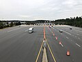 Toll station on State Route 267 (Dulles Toll Road), which provides easy access from Washington, DC to the Dulles International Airport.
 -

![All Interstate Highways in Virginia are and should be tagged with highway=motorway, as there are no major at-grade intersections along any of them in the state.[3]](/wiki/File:Intersection_of_Interstates_77_and_81_-_Exit_81.jpg)
.jpg)
_just_north_of_Dumfries_in_Prince_William_County,_Virginia.jpg)
_from_the_overpass_for_U.S._Route_15_Business_and_U.S._Route_29_Business_(Lee_Highway)_in_Warrenton,_Fauquier_County,_Virginia.jpg)
_from_the_overpass_for_Virginia_State_Route_950_(Ariane_Way)_in_Dulles,_Loudoun_County,_Virginia.jpg)

Trunk roads
Since 2021, an effort to change the criteria of highway=trunk from expressway to a generally important, long-haul highway (i.e. usually one that should be an Interstate or any other divided highway but is not) has been made in the Northeastern and Western United States. highway=trunk can still be applied to expressways and freeways lacking proper grade separation, but when one isn't a highly-significant highway or closely follows another, more-important road tagged with highway=motorway or highway=trunk it should be tagged as highway=primary or lower with expressway=yes.
Another use for highway=trunk is for filling gaps in mostly-highway=motorway roads that have at-grade intersections or a lack of a central median or barriers. It can also be used for vital bridges over bodies of water with minimal crossings such as the Potomac River and Chesapeake Bay.
Trunk destinations
A road tagged with highway=trunk should typically be a road usually preferred for long-distance travelling and connects important towns and cities. Places that should be connected by trunk roads (if not already fully or mostly connected by motorways) are the big three metropolitan areas of Virginia (Greater Richmond Region, Washington metropolitan area, and Hampton Roads) and the independent cities. Major out-of-state population centers as well as major airports and seaports within the state should be considered too.
Virginia is a very populated state with many large and important population centers. Here are the destinations in Virginia that should be linked by highway=trunk routes if not fully-linked by highway=motorway:
- Places within Virginia
This list includes Virginia's independent cities and every town with a population of over 5,000. Some of these places are already served by Interstates and may not need trunk routes. This list will inevitably be subject to changes as we work on gathering places to include and figuring out which to exclude. CDPs are currently in the process of being added to the list.
- Abingdon
- Alexandria - includes Huntington
- Arlington
- Ashburn - includes Lansdowne
- Ashland
- Bedford
- Blacksburg
- Bluefield
- Big Stone Gap
- Bridgewater
- Bristol
- Buena Vista
- Charlottesville
- Chesapeake
- Christiansburg
- Colonial Heights
- Covington
- Culpeper
- Danville
- Dumfries - includes Montclair, Quantico, and Triangle
- Emporia
- Fairfax
- Falls Church
- Farmville
- Fredericksburg
- Galax
- Gainesville - includes Haymarket
- Hampton
- Harrisonburg
- Herndon
- Hopewell
- Leesburg
- Lexington
- Linton Hall - includes Bristow
- Lynchburg
- Manassas - includes Bull Run, Manassas Park, and Sudley
- Marion
- Martinsville
- Newport News
- Norfolk
- Norton
- Petersburg
- Portsmouth
- Poquoson
- Pulaski
- Purcellville
- Radford
- Richlands
- Richmond
- Roanoke
- Salem
- Smithfield
- South Boston
- South Riding - includes Stone Ridge
- Springfield - includes Kingstowne, Franconia, Rose Hill, and West Springfield
- Stafford
- Sterling
- Strasburg
- Staunton
- Suffolk
- Vienna
- Vinton
- Virginia Beach
- Warrenton
- Waynesboro
- Williamsburg
- Winchester
- Woodbridge - includes Dale City, Lake Ridge, and Occoquan
- Woodstock
- Wytheville
- External trunk destinations
These are external population centers near the Virginia border. Further-out destinations can be considered too.
- Washington, D.C.
- Middlesboro, Kentucky
- Frederick, Maryland - includes Ballenger Creek
- Burlington, North Carolina
- Durham, North Carolina
- Elizabeth City, North Carolina
- Greensboro, North Carolina
- Henderson, North Carolina
- Mount Airy, North Carolina
- Oxford, North Carolina
- Raleigh, North Carolina - includes Cary and Wake Forest
- Reidsville, North Carolina
- Roanoke Rapids, North Carolina
- Bristol, Tennessee
- Johnson City, Tennessee
- Kingsport, Tennessee
- Beckley, West Virginia
- Charles Town, West Virginia - includes Ranson
- Martinsburg, West Virginia
Examples
-
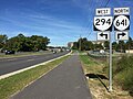 Prince William Parkway, which consists of State Route 234 and State Route 294, is a cross-county expressway connecting the two highly-populated sections of the county and three important highways; US 1, I-95, and I-66.
 -
 Virginia State Route 262 is a super-two for the majority of its route and acts as a semi-circular beltway around Staunton.
 -
 U.S. Route 460 is a typical divided
highway=trunkroad in Virginia, as it connects major cities such as Roanoke, Lynchburg, Chesapeake, and Norfolk. -
 U.S. Route 15 acts a vital crossing over the Potomac River into Maryland, connecting both Leesburg and Frederick, MD.
_at_Kenwood_Drive_in_Lake_Ridge,_Prince_William_County,_Virginia.jpg)
_from_the_overpass_for_Virginia_State_Route_254_(Parkersburg_Turnpike)_in_Cedar_Green,_Augusta_County,_Virginia.jpg)
.jpg)

Primary roads
The tag highway=primary is typically used on U.S. Routes and other major primary state routes (excluding minor primary highways serving state institutions) that do not meet the standards for highway=trunk or highway=motorway, and often any other major secondary or unsigned road that can be just as important as those. Highways that can be tagged as highway=primary include:
- major arterials and thoroughfares through urban or suburban areas
- significant main streets through cities and towns
- highways that connect smaller towns rather than the larger ones that a highway=trunk road would do
A road tagged with highway=primary should link to another important route such as a highway=trunk route, a highway=motorway, or another highway=primary road. Not all highway=primary roads move the same amount of traffic. A determination for whether a road is primary is if it is the preferred route through the area, usually when highway=trunk or highway=motorway routes are unavailable.
-
 Broad Street is a major thoroughfare through Downtown Richmond, and is part of U.S. Route 250.
 -
 VA 644 in Fairfax County (Old Keene Mill Road/Franconia Road) is a good example of a secondary highway that acts as a major thoroughfare. It connects multiple communities and highways.
 -
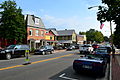 While still a national highway, U.S. Route 50 from Paris to Aldie does not connect any large communities, and only passes through small villages like Middleburg (pictured), therefore it is not tagged with
highway=trunk.

_as_it_leaves_the_Mixing_Bowl_in_Springfield,_Virginia.jpg)

Secondary roads
highway=secondary is primarily for roads that fit right between highway=tertiary and highway=primary and should be used on Secondary State Routes and unsigned roads. They may have more direct connections with other highways than highway=tertiary roads, but less important than those tagged with highway=primary. Highways that can be tagged as highway=secondary include:
- less major arterials that still have interchanges with highway=motorways or direct connections to other major highways
- alternatives to major highways, such as highway=primary, highway=trunk, and highway=motorway routes
- highways that only serve small hamlets and villages
- generally any other lower-grade roads that still have enough significance or move enough traffic to be classified over highway=tertiary, including any that only link other highway=secondary roads
Tertiary roads
highway=tertiary is for backroad Secondary State Routes and unsigned highways, residential area roads that can be used for passing through directly to another road, any arterial that doesn't act as a road that most vehicles would prefer when passing through, and other minor roads that are still somewhat significant in a way.
Minor roads
highway=residential — usually minor roads through residential areas, also commonly used for minor roads in commercial or mixed-use areas or dead-end arterials.
highway=unclassified — usually minor, sometimes nameless roads, usually through industrial, forest, or agricultural areas
Service roads

highway=service — unnamed roads in commercial and industrial areas
service=alley — a narrow street or driveway between buildings
service=emergency_access — small roads usually gated or signed for authorized vehicles (emergency, construction, and maintenance vehicles) exclusively
service=driveway — driveways serving houses or residential areas
service=drive-through — drive-through roads at businesses such as fast food establishments, banks, or car washes
service=parking_aisle — a road in a parking lot for accessing spaces
highway=track — an unmaintained dirt or gravel road formed by vehicles driving over land like dirt, grass, or sand
Expressways
In the US, highway=trunk used be almost exclusively for expressways (high-speed, limited-access roads). However, since highway=trunk and highway=motorway are of the same importance, highway=trunk should also be used for non-expressway roads that are just as important as highway=motorways. For tagging expressways, use the tag expressway=yes.
Traffic control
A lot of signalized intersections in Virginia do lack traffic signals as a point on OpenStreetMap to indicate that they are there. If you come across any signalized intersections lacking traffic signals on OSM, be sure to add them as a point using highway=traffic_signals. You can do the same for intersections with stop signs and yield signs using highway=stop and highway=give_way respectively. There is no firm consensus for whether signals and multi-way stop signs should be placed on the stop line or on the node where the affected roads meet, but doing so either way is effective and gets the job done. Yield signs and one-road stop signs only affect one direction and therefore should be placed on the stop line to not interfere with the unaffected road(s).
Links
Highway ramps, flyovers, slip lanes, and RIROs should all be tagged as highway link:
highway=motorway_linkhighway=trunk_linkhighway=primary_linkhighway=secondary_linkhighway=tertiary_link
The link should always be tagged for the greater-class road it connects to. For example, at an intersection with highway=secondary and highway=primary roads, the slip lanes should be tagged as highway=primary_link.
See also
References
- ↑ “Virginia's Highway System”. Retrieved 27 August 2021.
- ↑ Morris, Joan (8 January 2010). “It's Offical: Springfield Interchange Project Met Its Budget”. Retrieved 27 August 2021.
- ↑ List of gaps in Interstate Highways