Zh-hant:Tag:amenity=place_of_worship
Jump to navigation
Jump to search
| 說明 |
|---|
| All places of worship independently of the religion or denomination get the tag amenity=place_of_worship. |
| 在OSM Carto中渲染 |
| 組: 宗教 |
| 用於這些元素 |
| 常用組合 |
| 狀態:習慣使用 |
| 此標籤的工具 |
How to Map
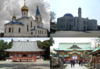
所有宗教或教派作禮拜/供奉/朝拜儀式的地方都應該用 amenity=place_of_worship 標籤(譯注: 我不確定原文 independently 的意思)。這包括了清真寺、教堂、大教堂、猶太教堂、祠廟等。你可以用 religion=*(宗教)、denomination=*(派別)、service_times=*(開放時間)等關鍵字來標明更詳細的資訊。
譬如,一個基督教禮拜堂可以有 amenity=place_of_worship、religion=christian(基督教)、building=church(教堂建物) 這幾個標籤。
對於修道院,這個標籤應該放在教堂上,而不是整個修道院。A draft (still not a proposal) exists for the communities (religious or not).
這個標籤只可用在祭台還有四周屬於宗教場所的建築。這並非用來標明土地利用的標籤,所以不應擴大到土地邊緣(這是常見的錯誤)。
Rendering
OSM Carto 在 zoom level > 16 時會畫出宗教場所。tiles@home 會用適當的象徵圖示表示教堂、清真寺、猶太教堂。

