Tag:man_made=bridge
| Description |
|---|
| The outline of a bridge, grouping together all features for that bridge. |
| Rendering in OSM Carto |

|
| Group: man made |
| Used on these elements |
| Useful combination |
| See also |
| Status: approved |
| Tools for this tag |
|
The tag man_made=bridge is used to tag a bridge defined by the outline of the bridge. It is suitable to group together all ways running over that bridge and for holding descriptive tags for that bridge (the object represents the bridge as a whole) and to mark shape of the bridge construction.
Tagging
Draw the outline of the bridge as ![]() area and apply man_made=bridge and layer=* to it. The outline should encompass the continuous structure of the bridge. Cables and pylons beside the bridge are tagged with bridge:support=*.
area and apply man_made=bridge and layer=* to it. The outline should encompass the continuous structure of the bridge. Cables and pylons beside the bridge are tagged with bridge:support=*.
Add the name of the bridge to the bridge outline (name=*) and the name of the roads to the road ![]() ways running over the bridge. Attributes of the bridge itself should be added to the outline.
ways running over the bridge. Attributes of the bridge itself should be added to the outline.
Ways across the bridge should be tagged with the same values of layer=* as the outline.
The key bridge=* can be used to indicate the type of the bridge, in which case its value set it should match bridge=* tagged on ways.
Where the ways cross the outline they should be connected to it with a shared node. Do not connect the ![]() ways running under the bridge to the outline.
ways running under the bridge to the outline.
Some mappers add covered=yes to segments of highway=* which pass under the man_made=bridge outline, but this is controversial.
Bridges with more than one level
The same as before but the key layer=* should now contain the lowest number of all the features on the bridge. To group together all features of the bridge the proposed relation bridge is now used and the outline tagged with man_made=bridge is added as outline-member to that Relation of the bridge itself should be added to the relation.
A new (alternative) proposal to map multi-level bridges using level=* and location=bridge is described in Proposed features/Simplify man made=bridge mapping#Multi-level bridges
Objects and features on bridges
See proposal objects on bridges for tagging with bridge=* or location=bridge and proposal Relations/Proposed/Bridges_and_Tunnels for using bridge relations.
Examples
One or more ways, one level
A bridge represented by only one OSM way, the outline is not drawn yet. The way itself is tagged with bridge=yes and layer=1. Draw the outline.
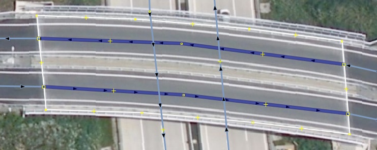
A bridge represented by two OSM ways, both of them at the same level. The ways are tagged with bridge=yes and layer=1. The outline is drawn and tagged with man_made=bridge and layer=1. The OSM ways are connected to the outline.
If the bridge has a specific name it would be added to the outline.
Multiple ways, two levels
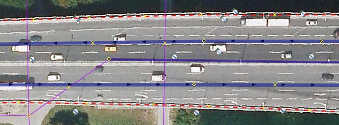
A large bridge with two carriage ways and a cycleway running below those. For better visibility only a part of the bridge is shown and the outline is displayed as a red-dashed line.
The OSM ways of the roads are tagged with bridge=yes and layer=2. The cycleway is tagged with bridge=yes and layer=1. The outline is drawn and tagged with man_made=bridge and layer=1. The proposed relation bridge is used to combine all features together and the OSM way of the outline is added as the outline-member to the relation.
The name of the bridge would be added to the relation.
See also
- bridge:structure=* - Load-bearing architecture of a bridge, can be added on man_made=bridge (note: there is no known solution for tagging bridges with mix of different structures)
- building=bridge - A building used as a bridge
- bridge=* - Mark a way as leading over a bridge and type of bridge
- start_date=* - Date when feature opened or the construction of the feature finished
- architect=* - Specifies the name of whoever architected the thing being tagged
- bridge:support=* - Position of the structures which support a bridge from beneath
- man_made=wildlife_crossing - Structure that allow animals to cross human barriers safely
- Drafted proposal for man_made=tunnel
- man_made=tunnel - Indicate the outline of a tunnel and group together all features for that tunnel
- Approved proposal for man_made=bridge
- Proposed relation for bridges and tunnels
- New proposal to refine some aspects of man_made=bridge
- Discussion on the tagging mailing list: Part 1 and part 2
- OverpassTurbo query that finds objects on bridges without nearby man_made=bridge


