Uk:Тайли
Тайли (дослівно "кахлі") – це прямокутні плитки з кераміки, що прикріплюються у вигляді мозаїки до стіни вашої ванної кімнати! Але тут ми хотіли б поговорити про квадрати мапи:
- прямокутні растрові зображення впорядковані за сіткою, для того щоб показувати мапу
- ми також іноді маємо на увазі поділені на тайли дані мапи.
На цій сторінці ми зібрали багато інформації та технічних деталей. Якщо ви бажаєте використовувати тайли мапи на вашій веб-сторінці або у застосунку ви можете ознайомитись з керівництвом використання тайлів OpenStreetMap.
Графічні тайли мапи
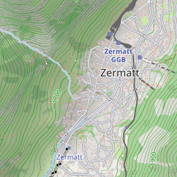
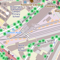
Тайли зазвичай є зображенням розміром 256×256 пікселів, наприклад:
Тайли не обов'язково мають такі розміри; так для використання на мобільних пристроях вони можуть бути 64×64 пікселів, про те зображення 256×256 пікселів є стандартом де-факто, зображення 515×512 пікселів є звичайним стандартом для тайлів з високою розподільчою якістю.
"Набір тайлів (tileset)" зазвичай включає достатню кількість тайлів, які формують велике зображення, коли вони показуються всі відразу, на різних рівнях наближення. Взагалі, ідея полягає не в тому, щоб показати їх всі відразу, а в тому щоб показати лише певну частину мапи на веб-сайті. Зазвичай для цього використовуються бібліотеки JavaScript, які дозволяють пересуватись мапою та змінювати масштаб мапи, завантажуючи нові тайли за потреби, щоб показати нові ділянки мапи користувачам (див Slippy Map).
Використання тайлів
- Перегляд мапи#Шари мапи пояснює, як вибрати тайли доступні для перегляду на головній сторінці openstreetmap.org
- Mapnik – популярний рендер для створення тайлів мапи
- Kosmos Tile Map Server – настільний рендер тайлів
- Правила використання тайлів OpenStreetMap
- Exporting calibrated maps містить перелік інструментів, які дозволяють робити тайли сумісними з певним програмним забезпеченням
- Tiletool – інструмент для обробки тайлів. За його допомогою можна створювати тайли для загальних масштабів (lowzoom) із тайлів докладних масштабів, накладати на них інші шари та виконувати інші операції.
Технічні дані
- Slippy map tilenames – допомагає вирахувати номер тайла, якщо у вас є координати
- Оцінка використання дискового простору під тайли
- Tile water land status ([3]), індекс тайлів що покривають сушу або воду, на мапі OSM, ця інформація доступна в SVN, у файлі png2tileinfo.
- Перелік змінених тайлів, надає перелік всіх тайлів на певному масштабі, які були змінені впродовж останьої доби від 1 години до 24 годин.
Розробка
- mod_tile – модуль Apache що опікується процесом надсилання запитів на редерінг тайлів в mapnik. Дивіться список розсилки OSM-Dev "mod_tile / renderd issue" (Травень 2008)
- Tile cache, рендер з підтримкою mapnik/mapserver/WMS так кещуванням тайлів.
- OSM Mobile Binary Protocol, дані OSM у вигляді тайлів(дивіться також WhereAmI/OSM Binary Format та обговорення в списку розилки - "mobile binary data" від 2008)
Сервери
See Servers/tile for the names of the physical servers that serve openstreetmap.org's map tiles.
See Servers/Tile CDN for description of tile servers maintained by OSM and how one may donate new server to it.For the URLs below:
{x} and {y} should be replaced with the x and y tile numbers.
{z} should be replaced with the zoom level.
{s} should be replaced by a subdomain. The exact values are in the tile server's documentation, but typically it is a single letter a, b, c and usually corresponds to Leaflet's {s} parameter[1]. Subdomains are used to help with browser parallel requests per domain limitation (not needed if the webserver uses http/2), so consider switching letters at runtime (similar to JOSM's url template construct {switch:a,b,c}).
| It is highly recommend to consult and follow usage policies of a given server! Respect their terms of use/tile usage policy. |
| Please don't forget to credit OpenStreetMap. See the Legal FAQ for details. Some tile services require their own attribution in addition. Ask their operator for details. |
Base maps
| Name | free/commercial | latency | IPv6 | comment | tiles url | Tile example | source code |
|---|---|---|---|---|---|---|---|
| OpenStreetMap's Standard tile layer openstreetmap.org front page usage policy compare |
free, funded by donations | 1 minute - 1 day | так | https://tile.openstreetmap.org/{z}/{x}/{y}.png | 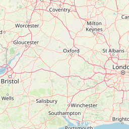
|
https://github.com/gravitystorm/openstreetmap-carto/ | |
| German variant of the Standard tile layer openstreetmap.de map usage policy compare |
free, funded by donations | 1 minute - 1 day | так | label in German and local language (transliterated where no name in Latin script is available), commercial and high-traffic use restricted | https://tile.openstreetmap.de/{z}/{x}/{y}.png | 
|
https://github.com/giggls/openstreetmap-carto-de/ |
| French variant of the Standard tile layer Priority given to French names and symbols (baguette instead of pretzel for bakery!). Special display for sport fields. usage policy compare |
free, funded by donations | 1 hour | так | Fork of OSM Carto. Some newer features are sometimes experimented and are discussed on the French OpenStreetmap mailing list. Guided tour of improved features. https and http/2 supported. | https://{s}.tile.openstreetmap.fr/osmfr/{z}/{x}/{y}.png | 
|
https://github.com/cquest/osmfr-cartocss map |
| Humanitarian map style Humanitarian focused OSM base layer usage policy compare |
free, funded by donations | 5 minutes - 1 day | так | map style info. https and http/2 supported. | https://{s}.tile.openstreetmap.fr/hot/{z}/{x}/{y}.png | 
|
https://github.com/hotosm/HDM-CartoCSS |
| CyclOSM cyclosm.org usage policy compare |
free, funded by donations | ~72 hours - 1 week | так | variants available: cyclosm, cyclosm-lite | https://{s}.tile.openstreetmap.fr/cyclosm/{z}/{x}/{y}.png https://{s}.tile-cyclosm.openstreetmap.fr/cyclosm-lite/{z}/{x}/{y}.png | https://github.com/cyclosm/cyclosm-cartocss-style/ | |
| ÖPNVKarte öpnvkarte.de compare |
free, funded by donations | так | https://tile.memomaps.de/tilegen/{z}/{x}/{y}.png | ||||
| OpenTopoMap Topographical Map compare |
free, see https://opentopomap.org/about#faq | немає | Imitating the official topographic map style of German Vermessungsämter. | https://{s}.tile.opentopomap.org/{z}/{x}/{y}.png | 
|
https://github.com/der-stefan/OpenTopoMap/tree/master/mapnik
| |
| Carto Light ("Positron") general map Required attribution: "Map tiles by Carto, under CC BY 3.0. Data by OpenStreetMap, under ODbL." compare |
commercial, registration required, uses Natural Earth at low zooms | немає | variants available: all, nolabels, only_labels | https://cartodb-basemaps-{s}.global.ssl.fastly.net/light_all/{z}/{x}/{y}.png | 
|
||
| Carto Dark ("Dark Matter") general map Required attribution: "Map tiles by Carto, under CC BY 3.0. Data by OpenStreetMap, under ODbL." compare |
commercial, registration required, uses Natural Earth at low zooms | немає | variants available: all, nolabels, only_labels | https://cartodb-basemaps-{s}.global.ssl.fastly.net/dark_all/{z}/{x}/{y}.png | 
|
||
| Carto Color ("Voyager") general map Required attribution: "Map tiles by Carto, under CC BY 3.0. Data by OpenStreetMap, under ODbL." compare |
commercial, registration required, uses Natural Earth at low zooms | немає | variants available: nolabels, only_labels, labels_under | https://cartodb-basemaps-{s}.global.ssl.fastly.net/rastertiles/voyager/{z}/{x}/{y}.png |
| ||
| MapTiler Streets Streets map compare |
commercial, registration required | так | you need to register to use this, a free tier for non-commercial use is available. | https://api.maptiler.com/maps/streets/{z}/{x}/{y}.png | 
|
||
| MapTiler Outdooor Outdoor map |
commercial, registration required | так | you need to register to use this, a free tier for non-commercial use is available. | https://api.maptiler.com/maps/outdoor/{z}/{x}/{y}.png | 
|
||
| MapTiler Pastel Pale map for overlaying own data |
commercial, registration required | так | you need to register to use this, a free tier for non-commercial use is available. | https://api.maptiler.com/maps/pastel/{z}/{x}/{y}.png | 
|
||
| MapTiler Basic Basic map compare |
commercial, registration required | так | you need to register to use this, a free tier for non-commercial use is available. | https://api.maptiler.com/maps/basic/{z}/{x}/{y}.png | 
|
| |
| Stamen Toner Black & White map compare |
commercial, with a free tier for non-commercial use under 200.000 tiles / month[2] | Weekly | так | Hosted by Stadia Maps. No registration necessary for local development; retina (HiDPI) tiles available.
Layer groups available: stamen_toner_labels, stamen_toner_lines, stamen_toner_background, stamen_toner_lite (docs). |
https://tiles.stadiamaps.com/tiles/stamen_toner/{z}/{x}/{y}.png | 
|
https://github.com/stamen/toner-carto (new repo for refreshed styles coming soon) |
| Stamen Watercolor Artistic map compare |
commercial, with a free tier for non-commercial use under 200.000 tiles / month[2] | Weekly | так | Hosted by Stadia Maps. No registration necessary for local development; retina (HiDPI) tiles available. | https://tiles.stadiamaps.com/tiles/stamen_watercolor/{z}/{x}/{y}.jpg | 
|
Not public, but they give the generated tiles and code to Cooper-Hewitt for real-time rendering.[3]
|
| Clockwork Micro Streets Streets map compare |
commercial, registration required | немає | you need to register to use this, a free plan is available. | https://maps.clockworkmicro.com/streets/v1/raster/{z}/{x}/{y}.png | |||
| OpenCycleMap OpenCycleMap compare |
commercial, registration required | hourly | так | you need to register to use this, a free plan is available. | https://api.thunderforest.com/cycle/{z}/{x}/{y}.png | 
|
unavailable, this is a closed source project |
| Thunderforest Transport Transport map compare |
commercial, registration required | hourly | так | you need to register to use this, a free plan is available. | https://api.thunderforest.com/transport/{z}/{x}/{y}.png |
| |
| Thunderforest Landscape Landscape map compare |
commercial, registration required | hourly | так | you need to register to use this, a free plan is available | https://api.thunderforest.com/landscape/{z}/{x}/{y}.png | 
|
|
| Thunderforest Outdoors Outdoors map compare |
commercial, registration required | hourly | так | you need to register to use this, a free plan is available | https://api.thunderforest.com/outdoors/{z}/{x}/{y}.png | 
|
|
| Slpy (formerly API.Wikiocity) Slpy map |
commercial, registration required | ~1 day | немає | you need to register to use this, a free plan is available. | https://api.wikiocity.com/r/raster/{language}/{z}/{x}/{y}.png | https://github.com/wikiocity/wikiocity-styles | |
| MapTiles English MapTiles with English labels |
commercial, registration required | ~ 2 weeks | немає | you need to register to use this, a free tier for non-commercial use is available. Updates happen after data checks and may therefore take longer than 2 weeks. | https://maptiles.p.rapidapi.com/en/map/v1/{z}/{x}/{y}.png | 
|
|
| MapTiles French MapTiles with French labels |
commercial, registration required | ~ 2 weeks | немає | you need to register to use this, a free tier for non-commercial use is available. Updates happen after data checks and may therefore take longer than 2 weeks. | https://maptiles.p.rapidapi.com/fr/map/v1/{z}/{x}/{y}.png | 
|
|
| MapTiles Spanish MapTiles with Spanish labels |
commercial, registration required | ~ 2 weeks | немає | you need to register to use this, a free tier for non-commercial use is available. Updates happen after data checks and may therefore take longer than 2 weeks. | https://maptiles.p.rapidapi.com/es/map/v1/{z}/{x}/{y}.png | 
|
|
| Geofabrik Standard OpenStreetMap Carto style (similar to www.openstretmap.org) compare |
commercial, registration required, trial available | OSM data updated minutely | немає | labels in local language | 
|
||
| Geofabrik German openstreetmap.de map (German OpenStreetMap Carto fork) compare |
commercial, registration required, trial available | OSM data updated minutely | немає | labels in German and local language, non-Latin characters are transliterated | 
|
||
| Geofabrik English OpenStreetMap Carto style (similar to www.openstretmap.org) but English labels compare |
commercial, registration required, trial available | OSM data updated minutely | немає | labels in English and local language, non-Latin characters are transliterated | 
|
||
| Geofabrik Topo base map suitable for outdoor activities, with hillshade and contours compare |
commercial, registration required, trial available | OSM data updated minutely | немає | labels in English and local language, non-Latin characters are transliterated | 
|
| |
| Omniscale base map |
commercial, registration required | немає | coloured base map, greyscale version and coloured version with hillshading available | ||||
| Retina Tiles OpenStreetMap-Carto styled retina tiles |
commercial, registration required | ~ 2 weeks | немає | you need to register to use this, a free tier for non-commercial use is available. Updates happen after data checks and may therefore take longer than 2 weeks. | https://retina-tiles.p.rapidapi.com/local/osm{r}/v1/{z}/{x}/{y}.png?rapidapi-key=XXX | 
|
|
| Standard Tiles OpenStreetMap-Carto styled standard tiles |
commercial, registration required | ~ 2 weeks | немає | you need to register to use this, a free tier for non-commercial use is available. Updates happen after data checks and may therefore take longer than 2 weeks. | https://retina-tiles.p.rapidapi.com/local/osm/v1/{z}/{x}/{y}.png?rapidapi-key=XXX | 
|
|
| Lima Labs Open carto Based map with Anglicized labels |
Commercial with a free tier up to 20,000,000 tiles yearly. Commercial traffic encourage on the free tier. Register for a free API key. | Quarterly | так | High res 512x512 tiles labeled in English and local languages where possible distributed from a global CDN. | https://cdn.lima-labs.com/{z}/{x}/{y}.png?api=demo | 
|
|
| Tracestrack Carto OSM-Carto based retina maps compare |
commercial, a free tier for non-commercial or low volume use is available. | < 10 days | так | 18+ language labels; localised road shields for several countries; elevation in feet in US; several colour variants; | https://tile.tracestrack.com/_/{z}/{x}/{y}.png, https://tile.tracestrack.com/en/{z}/{x}/{y}.png, https://tile.tracestrack.com/[ar|de|es|fi|fr|he|hu|it|ja|ko|nl|pl|pt|ru|uk|sv|th|tr|zh-hans|zh-hant]/{z}/{x}/{y}.png, etc | 
|
|
| Tracestrack Topo Combined OSM-Carto with OpenTopoMap compare |
commercial, a free tier for non-commercial or low volume use is available. | < 10 days | так | 18+ language labels; localised road shields for several countries; elevation in feet in US; several colour variants; | https://tile.tracestrack.com/topo__/{z}/{x}/{y}.png?key=XXX, https://tile.tracestrack.com/topo_en/{z}/{x}/{y}.png?key=XXX, https://tile.tracestrack.com/topo_[ar|de|es|fi|fr|he|hu|it|ja|ko|nl|pl|pt|ru|uk|sv|th|tr|zh-hans|zh-hant]/{z}/{x}/{y}.png?key=XXX, etc | 
|
|
| Geoapify Map Tiles OSM-based map tiles |
commercial, a free tier for low volume use is available. Registration required | Monthly updates after data checks | так | OSM Carto, OSM Bright and variants, Klokantech Basic, Toner and variants, Positron and variants, Dark Matter and variants | https://maps.geoapify.com/v1/tile/osm-bright-smooth/{z}/{x}/{y}.png | 
|
|
| Stadia Alidade Smooth View map |
commercial, with a free tier available for non-commercial use | Weekly | так | No registration necessary for local development; retina (HiDPI) tiles available | https://tiles.stadiamaps.com/tiles/alidade_smooth/{z}/{x}/{y}.png | 
|
|
| Stadia Alidade Smooth Dark View map |
commercial, with a free tier available for non-commercial use | Weekly | так | No registration necessary for local development; retina (HiDPI) tiles available | https://tiles.stadiamaps.com/tiles/alidade_smooth_dark/{z}/{x}/{y}.png | 
|
|
| Stadia Outdoors View map |
commercial, with a free tier available for non-commercial use | Weekly | так | No registration necessary for local development; retina (HiDPI) tiles available | https://tiles.stadiamaps.com/tiles/outdoors/{z}/{x}/{y}.png | 
|
|
| Stadia OSM Bright View map |
commercial, with a free tier available for non-commercial use | Weekly | так | No registration necessary for local development; retina (HiDPI) tiles available | https://tiles.stadiamaps.com/tiles/osm_bright/{z}/{x}/{y}.png | 
|
|
| MapBox [4] |
commercial | так | Uses various data sources including OSM. Formerly open data and open source with a free tier available; nowadays also proprietary software and closed data. | https://github.com/mapbox (partial) | |||
| Interactive Maps Company website |
commercial | As required | так | Regions and styles adjusted for customer requirements |
Overlay tiles
Overlay tiles work best when used on top of a base map.
| Name | free/commercial | latency | IPv6 | comment | tiles url | Tile example | source code |
|---|---|---|---|---|---|---|---|
| OpenRailwayMap Railway infrastructure Usage policy compare |
free, funded by donations, see policy | 1 minute - 1 day | так | Railway infrastructure | https://{s}.tiles.openrailwaymap.org/standard/{z}/{x}/{y}.png | https://github.com/OpenRailwayMap/OpenRailwayMap | |
| OpenRailwayMap Railway maxspeeds Usage policy compare |
free, funded by donations, see policy | 1 minute - 1 day | так | Railway maxspeeds | https://{s}.tiles.openrailwaymap.org/maxspeed/{z}/{x}/{y}.png | https://github.com/OpenRailwayMap/OpenRailwayMap | |
| OpenRailwayMap Railway signalling Usage policy compare |
free, funded by donations, see policy | 1 minute - 1 day | так | Railway signalling and train protection signals | https://{s}.tiles.openrailwaymap.org/signals/{z}/{x}/{y}.png | https://github.com/OpenRailwayMap/OpenRailwayMap | |
| OpenRailwayMap Railway electrification Usage policy compare |
free, funded by donations, see policy | 1 minute - 1 day | так | Railway electrification | https://{s}.tiles.openrailwaymap.org/electrified/{z}/{x}/{y}.png | https://github.com/OpenRailwayMap/OpenRailwayMap | |
| OpenRailwayMap Railway track gauge Usage policy compare |
free, funded by donations, see policy | 1 minute - 1 day | так | Railway track gauge | https://{s}.tiles.openrailwaymap.org/gauge/{z}/{x}/{y}.png | https://github.com/OpenRailwayMap/OpenRailwayMap | |
| waymarkedtrails Hiking routes usage policy compare |
free, see policy | 1 day | так | Using osmc:symbol=*
|
https://tile.waymarkedtrails.org/hiking/{z}/{x}/{y}.png | 
|
https://github.com/waymarkedtrails/waymarked-trails-site |
| waymarkedtrails Cycling routes usage policy compare |
free, see policy | 1 day | так | https://tile.waymarkedtrails.org/cycling/{z}/{x}/{y}.png | 
|
https://github.com/waymarkedtrails/waymarked-trails-site | |
| waymarkedtrails Riding routes usage policy compare |
free, see policy | 1 day | так | Horse riding, using osmc:symbol=*
|
https://tile.waymarkedtrails.org/riding/{z}/{x}/{y}.png | 
|
https://github.com/waymarkedtrails/waymarked-trails-site |
| OpenSeaMap Sea marks compare |
free, funded by donations | Sea marks only, background transparent | http://tiles.openseamap.org/seamark/{z}/{x}/{y}.png | 
|
|||
| Tracestrack Bus routes |
commercial, a free tier for non-commercial or low volume use is available. | 2 weeks | Bus routes only, background transparent | https://tile.tracestrack.com/bus-route/{z}/{x}/{y}.png | 
|
https://github.com/tracestrack/bus-routes-layer | |
| Tracestrack Subway routes |
commercial, a free tier for non-commercial or low volume use is available. | 2 weeks | Subway routes only, background transparent | https://tile.tracestrack.com/subway-route/{z}/{x}/{y}.png | 
|
||
| Tracestrack Train routes |
commercial, a free tier for non-commercial or low volume use is available. | 2 weeks | Train routes only, background transparent | https://tile.tracestrack.com/train-route/{z}/{x}/{y}.png | 
|
||
| Tracestrack Bicycle routes |
commercial, a free tier for non-commercial or low volume use is available. | 2 weeks | Bicycle lanes and routes, background transparent | https://tile.tracestrack.com/bicycle-route/{z}/{x}/{y}.png | 
|
Regional tile servers
| Name | free or commercial | latency | IPv6 | Region | tiles url | Tile example | source code |
|---|---|---|---|---|---|---|---|
| openstreetmap-carto rendering from SOSM standard usage policy |
free, donated resources | 1 hour | так | Switzerland | https://tile.osm.ch/switzerland/{z}/{x}/{y}.png | https://tile.osm.ch/switzerland/14/8544/5827.png | https://github.com/sosm/openstreetmap-carto |
| OSM-Swiss-Style link to the map usage policy |
free, donated resources | 1 hour | так | Switzerland | https://tile.osm.ch/osm-swiss-style/{z}/{x}/{y}.png | https://tile.osm.ch/osm-swiss-style/15/17062/11532.png | https://github.com/sosm/OSM-Swiss-Style |
| OSM Belgium link to the map usage policy compare |
free, see policy | немає | Belgium | https://tile.openstreetmap.be/osmbe/{z}/{x}/{y}.png | https://github.com/osmbe/openstreetmap-carto-be | ||
| OSM Belgium NL link to the map usage policy compare |
free, see policy | немає | Belgium with Dutch labels | https://tile.openstreetmap.be/osmbe-nl/{z}/{x}/{y}.png | https://github.com/osmbe/openstreetmap-carto-be | ||
| OSM Belgium FR link to the map usage policy compare |
free, see policy | немає | Belgium with French labels | https://tile.openstreetmap.be/osmbe-fr/{z}/{x}/{y}.png | https://github.com/osmbe/openstreetmap-carto-be | ||
| SomeoneElse-style standard Normal usage, no bulk downloading |
United Kingdom, Ireland and Crown Dependencies | https://map.atownsend.org.uk/hot/{z}/{x}/{y}.png | https://map.atownsend.org.uk/hot/17/65497/43590.png | https://github.com/SomeoneElseOSM/SomeoneElse-style |
Також дивіться сервіс порівнння мап від bbbike.org. Будь ласка, дотримуйтесь правил користування кожного тайлового сервіса!
Також подивіться mapstyle.petschge.de та Leaflet Provider Demo.
Примітки:
Дані у вигляді тайлів
- QuadTiles, схема, що дозволяє індексувати дані OSM у вигляді тайлів
- OJW's tile data server, перша реалізація кешуючого сервера даних, який обслуговує дані так само, як і tileserver.
- Tile data server, загальне визначення того, як повинні працювати дані у вигляді тайлів (також створене ojw...)
Посилання
- Switch2OSM, Основи Сторінка містить деяку інформацію про тайлів, ліцензій та JavaScript-бібліотеки для показу.