Zh-hant:Key:embankment
Jump to navigation
Jump to search
 |
| 說明 |
|---|
| 乘載道路、鐵路、運河穿越低地或溼地區域的抬升土堤。 |
| 組: 屬性 |
| 用於這些元素 |
| 参照 |
| 狀態:習慣使用 |
| 此標籤的工具 |
在交通運輸中,土堤是乘載道路、鐵路、運河通過低地或溼地的土堤。如果低地區域永久性沒入水中或每逢潮汐氾濫,此類土堤稱作「causeway」。
它也可能是被土地環繞的人工土堤,用來引導或防止海水、湖水、河水的氾濫。請參見Proposed_features/Dyke。
使用方法
在已經標記highway=*、railway=*、waterway=*的路徑上,加入embankment=yes。
微觀繪製時,您能使用兩條平行路徑,並同時加入man_made=embankment,詳情請參見下文。
與橋梁不同,土堤鮮少需要layer標籤,除非有合理的理由,否則不應使用。
渲染
單一線段土堤
土堤與公路、鐵路、水路共用路徑,將在兩側渲染尖角紋。(只適用Osmarender,其不再維護。)
微觀繪製土堤
此類土堤將以「路徑左側為高處、路徑右側為低處」渲染。(OSM Mapnik支援,只適用帶有man_made=embankment標籤的非封閉的路徑,不適用帶有embankment=yes標籤的路徑。)
- To represent a raised finger of land (as in the illustration): draw two ways bordering the raised land, each tagged
man_made=embankmentand going in opposite directions. - To present a banked enclosure (such as an iron-age hill fort): draw two ways with the outer way travelling anticlockwise and the inner way clockwise. Additional ways can be used to present ditches, scarps, aprons and terraces in large sites. Note that if a closed way is drawn without two breaks (creating two separate but connected ways) then it will be interpreted as an area and not displayed in the Standard layer.
圖片
-
 Line art drawing of a Embankment
 -
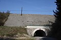 Tunnel and railway embankment near Přibyslavice.
 -
 Embankment at Argyll Road Looking out from the tunnel under Glasgow Road.
 -
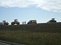 Road embankment work - Hatton Bends.
 -
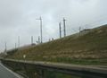 Railroad embankment.
 -
 Vale of Rheidol Railway Embankment.
 -
 Railroad causeway on top of an embankment.
 -
 Railroad causeway on top of an embankment.
.png)


