Ko:Key:covered
 |
| 설명 |
|---|
| 객체가 무언가로 덮여 있는지를 나타내는 속성 |
| 그룹: 속성 |
| 해당 요소의 사용 |
| 유용한 조합 |
| 같이 보기 |
|
| 상태:승인 |
| 이 태그를 위한 도구 |
covered=*는 노드, 길 또는 영역으로 표현된 객체가 덮여 있는지를 나타내는 데 씁니다.
For highways and railways this differs from tunnel=* in that it is usually open at least on one side. This then implies covered=yes.
Also used in some situations where use of layer=* is not meaningful.
사용
Use this tag for:
- Highways, footways, railways, or waterways that are (even partially) covered by a building or other structure other than where
tunnel=*(includingtunnel=building_passage) applies. - Power lines, water mains, water drains, etc. in a narrow trench, with coverings traversable by traffic (foot, vehicle, or otherwise) and removable for access and maintenance.
- Buried objects other than where
location=undergroundapplies, like an area such as an underground parking lot, a covered reservoir/cistern or even such things as an aquarium (e.g., Kelly Tarlton's, Auckland, NZ), when the covering is not a man-made structure that would allow layer differentiation. amenity=bicycle_parkingwhich is protected from rain.
Some mappers use this tag for:
- Highways under the area of a
man_made=bridge. This is controversial, see Talk:Key:covered.
Do not use this tag for:
- Objects in tunnels (
tunnel=*) where layering (layer=*) is established. - Avalanche protectors (
tunnel=avalanche_protector) even where open on one side. - covered bridges
bridge=covered). - Where
location=undergroundorlocation=underwaterapplies.
태그 방법
Ways passing through buildings should normally have the same (or none) layer as the building.
When used this way the building and the way should have shared nodes at the entry and exit points of the building. The way should be split at the entry and exit nodes and only the part covered by the building should be tagged with covered=yes.
covered=no
Marks that an object is not covered.
covered=yes
For covered objects which are not covered by an arcade or a colonnade. This tag was approved by proposed features/covered.
The following tags are in use, but were not included in the original proposal:
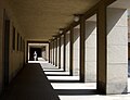
covered=arcade
An arcade is a succession of arches, each counterthrusting the next, supported by columns or piers or a covered walk enclosed by a line of such arches on one or both sides.[1]
Such ways should be tagged with covered=arcade. If the arcade is part of a building, the building and the way share the same node at the entry and exit points. The way is split at the entry and exit nodes and only the part covered by the building is tagged with covered=arcade The layer has to be the same as the building. So if the building doesn't have a layer tag, the way doesn't need one either. Use arcade:left=open or arcade:right=open to define which side of the way is open.
When arcade should not be used:
It is not meant to be used for indoor mapping. The wall on one side is considered as an outer wall which can have entrances that lead into the building. For indoor mapping indoor=yes can be used.
Also it is not meant to be used for simple roof overhangs or blind arcades.
-
 A typical arcade in South Tyrol

covered=colonnade
아케이드와 비슷하지만 구조적으로 다른 줄기둥(colonnade)은 잇달아 줄지어 선 기둥이며, 종종 건물의 일부로써 혹은 따로 세워지기도 합니다.[2]
이러한 길에는 covered=colonnade로 태그를 지정해야 합니다. 건물의 일부인 경우 건물과 길은 입구와 출구 지점에서 같은 노드를 가집니다. 도로는 입구와 출구 노드에서 분할되며 건물이 덮고 있는 부분에만 covered=colonnade로 태그가 지정됩니다. 레이어는 건물과 같아야 합니다. 따라서 건물에 레이어 태그가 없는 경우 길에도 레이어가 필요하지 않습니다. colonnade:left=open 또는 colonnade:right=open을 사용하여 길의 어느 쪽이 열려 있는지 정의합니다.
줄기둥을 쓰면 안 되는 경우:
실내 매핑에서는 쓰면 안 됩니다. 한쪽 벽은 건물로 연결되는 입구가 있을 수 있는 외벽으로 간주됩니다. 실내 매핑의 경우 indoor=yes를 사용할 수 있습니다.
또한 단순한 지붕 돌출부에는 사용할 수 없습니다.(이런 경우에는 '들머리처마'가 더 알맞을 수 있습니다.)
-
 칸슬리후셋 아카드 (이름 때문에 헷갈릴 있습니다. 이 구조물은 '아케이드'가 아닌 '줄기둥'입니다.)
 -
 로마 성 베드로 대성당 앞에 있는 유명한 바로크 건축가 지안 로렌조 베르니니의 줄기둥


covered=partial
Some mappers use this tag to show that an object is only partially covered (e.g. by a roof), as covered=yes would mean it is full-covered or people interpret this as being full-covered. covered=partial sometimes applies to railway and other public transport platforms (e.g. railway=platform), where the platform should usually be one object (one feature, one OSM element), and when people then want to use covered=* to show that is covered in part. But if so, consider drawing another way for where the roof is and add building=roof and the suitable layer=* tag for the roof, at least additionally, or even instead.
covered=booth
This tagging is used for public telephones (amenity=telephone) which are full-covered by a phone booth with door. The tag covered=booth was chosen first to make it possible to differentiate between a full-cover booth and a roof (which would be tagged with covered=yes) and second because the tag shelter=yes does not have the same meaning. shelter=yes on an object shows that there is an amenity=shelter at this object and this is not the same as a phone booth. A phone booth is intended to cover the person who is using the phone, but it's not a shelter where several people can wait on a bus or stay protecting them from rain comfortable.
Please note that covered=booth is the above-tag for the key booth=*, which specifies the type of booth.
For tagging a phone booth which is used as a public bookcase, please use amenity=public_bookcase + public_bookcase:type=phone_box + booth=<boothtype> instead. covered=booth is not so appropriate for these, because this tag describes how a feature is covered, not the feature itself (which would be a public bookcase then). Former phone booths which are public bookcases now are the one exception where booth=* can be added without adding covered=booth before.
보기

추가 속성
maxheight=* may also be associated with the covered way or area to indicate clearance.
Rationale
This section changed since the approval of this feature as a result of refinement of the definition of the layer=* tag.
While using the layer or level tags is the conventional means of showing that one object is above another there are numerous situations where these tags are inappropriate and can be misleading in the context of the subsystem being mapped.
For example, when a building has a way passing through it, the building and the way through it can not be assigned distinct layers. In this situation tunnel=building_passage is used when the way has outer building walls to all sides. The tag covered=* is used when the way is open on at least one side.
A tag covered=* on the way will make routing more efficient in cases where, for example, a route to avoid the natural elements is desired, or a route to covered parking or to an area for sheltered entry or egress into a vehicle is desired.
In other cases objects can be assigned a distinct layer but can not be represented by either a bridge, tunnel, or indoor mapping - in those cases covered=* provides a simple method to express such situations.
Another use case; some objects such as underground parking garages and reservoirs are covered by an object that would not be mapped separately.
함께 보기
tunnel=*shelter=*building=roofleisure=outdoor_seatingandweather_protection=*- Proposed features/covered
- Proposed features/building passage
- Simple 3D buildings#Roof
- arcade on wikipedia
- Covered bridge(위키백과)