Hi, I think you've made a good point, none probably isn't a good name for the value. The problem with ground is that the pin/bolt might be embedded in something other than the ground - maybe a boulder, boardwalk, etc. What do you think of changing none to pin? --Kylenz (talk) 22:48, 5 June 2021 (UTC)Reply
Hi, I think your suggested change for the marker=* tag is logical. As User:Kovposch said, ground is not a "structure", so it doesn't make sense for the survey_point:structure=* tag. I think pin/bracket/etc. is more descriptive than ground, it allows us to specify more detail, so it is better (?) What do you think? --Kylenz (talk) 05:58, 8 June 2021 (UTC)Reply
Latest comment: 4 years ago27 comments4 people in discussion
Resolved
Why would you deprecate a tag as basic as survey_point=* when you have not touched the other main attributes, ie method (eg triangulation), spatial measure (eg horizontal control), and purpose (eg national datum). ---- Kovposch (talk) 07:47, 6 June 2021 (UTC)Reply
Hi, survey_point=* is used very varyingly, almost like the source=* tag. See the taginfo page. We can't propose to repurpose this tag since it is used 12,389 times for very different purposes. And it would be impossibly hard to clean up every single one. So, I think the namespace approach works well, because as you alluded to, it's easy to add new tags to describe other features of survey points. --Kylenz (talk) 21:27, 6 June 2021 (UTC)Reply
No matter what a tag usage is, it's possible to review a few values with definitions that get consensus. Introducing namespaces because of existing values that could be barely cleaned up is not so useful. Furthermore it doesn't encourage to cleanup original survey_point=*. I could just add new survey_point:structure=* and leave survey_point=* untouched Fanfouer (talk) 21:44, 7 June 2021 (UTC)Reply
Hi, I agree that is it unfortunate that we can't repurpose survey_point=*. There are two problems that we cannot work around:
1. Cleaning up the 12,000 nodes with the survey_point=* tag is an impossible task. We would need to consult with the mappers of all 12,000 nodes to ensure we don't delete valuable information. OSM also does not allow automated edits for situations like these (See Automated Edits/Code of Conduct) so this is simply not feasable.
2. We cannot create a proposal for a tag that is already in use for a different purpose (especially one that is used 12,000 times).
Let's keep it relative to whole population of man_made=survey_point: more than 300k occurrences. Cleaning survey_point=* isn't an unachievable goal, particularly when you define new values. When it came to clean up tower:type=* from power lines, there was more than 40k values to remove and adapt and it goes well. See this diary for more informations and return on experiences.
I still don't get why you don't take the opportunity to encourage manual changes over survey_point=* with this proposal. You'll get not only cleaned features but you will certainly get many more than 12k survey point qualified with approved survey_point=* values instead of now. Fanfouer (talk) 18:33, 8 June 2021 (UTC)Reply
You can make it approved with a few well defined values (currently proposed in survey_point:structure=*). Rolling out those values will encourage mappers to replace existing tagging at the same time and produce a greatly usable piece of data about survey points. This will be simple tagging, without namespaces. From 12k survey points currently qualified, you'll easily get 100k occurrences of approved values. Fanfouer (talk) 22:49, 8 June 2021 (UTC)Reply
I disagree with this for the same reason stated in the beginning. I'm only opposed to deprecating all of survey_point=* flat-out. I support adding survey_point:structure=*. This is a fine proposal about a particular attribute of this feature. It's not a must to ask for a expansion in coverage. Deprecatable values can be identified for migration. ---- Kovposch (talk) 02:39, 9 June 2021 (UTC)Reply
Some things, like the alignment with the local geodetic datum can't be expressed with Lifecycle prefix tags. In this thread's original message, User:Kovposch also suggested some future detail that would need to be expressed using namespaced tags. So, regardless we will end up with some namespaced tags for survey points. So for consistency, I think it's better to use survey_point:structure=* over survey_point=*. But I will update the proposal to not deprecate survey_point=*. --Kylenz (talk) 03:26, 10 June 2021 (UTC)Reply
Such reasoning lead to fire_hydrant:position=* in place of location=* which causes a little harm actually. Finally, why existing marker=* isn't suitable for survey points? They depict a structure, currently used in combination with utility=* for utility markers but could be used with man_made=survey_point as well, could't you? I'm not against namespaces in general, I intend to use them only when necessary. Fanfouer (talk) 22:21, 10 June 2021 (UTC)Reply
Using marker=* sounds like a good idea, but there could be issues. Would beacon/cut/bracket/magnet be valid values for marker=*?
That's good questions and I think yes, marker=* could be completed with additional necessary values. Look at marker=plate's definition: only valid on a not dedicated support. If you find a cut or a bracket on a dedicated stone, I'd be tempted to use marker=stone. Same question applies currently on survey_point:structure=bracket vs survey_point:structure=pillar.
Unless with a valid example provided, I don't think survey points could be mixed with utility markers: the first is installed at a precise place while second are here to warn about buried feature and can be changed/altered/destroyed/replaced at any time with no precise position. Fanfouer (talk) 22:20, 11 June 2021 (UTC)Reply
Yeah, I think using marker=* could lead to some confusion though. We may find features tagged as man_made=survey_pointandutility=*. As you alluded to, another point of confusion may be that marker=* implies something haphazardly placed, purely for informative purposes, whereas man_made=survey_point is very precisely placed. Seeing both those tags on one feature seems unexpected. And I suspect the possible values for survey_point:structure=* and marker=* will continue to diverge, and we will want some more specific values for survey point than normal markers. Like cut/bracket/magnet which wouldn't really be valid values for marker=*... --Kylenz (talk) 02:17, 14 June 2021 (UTC)Reply
marker=* implies nothing but a visible structure of a marker. It includes not only utility markers but also milestones and property limits, there is no normal markers, each one got its own purpose. Erroneous combinations of man_made=survey_point and utility=* are advisable in QA tools, no problem to make them both incompatible. It's desirable and correct to separate purpose (man_made=survey_point, utility=*...) and structure/appearance (marker=*). Again, we had similar discussions about fire hydrants with particular tags that covers more general ones and prevent wider tagging extension for common good now. No problem to add as many value as needed in marker=* as well. Fanfouer (talk) 22:45, 14 June 2021 (UTC)Reply
It seems wrong to create tags like marker=beacon and marker=cut, because these will never be valid when used with utility=*. I think this may also cause confusion in editors, because they will suggest all the common values for marker=* when you add a utility=*, some of which will not be valid for man_made=survey_point and others will not really be valid for utility=*, but editors/software won't know this. Is there actually a benefit in using marker=*? It seems like we are justifying that potential points of confusion aren't that bad, when the simpler approach would be just to use survey_point:structure=* as currently proposed --Kylenz (talk) 01:49, 15 June 2021 (UTC)Reply
Why beacon and cut won't be valid with utility? We already have marker=stone which is actually barely used in combination with utility=*. marker=*can be used in combination with utility=*, not must. Software also can be aware of awkward combinations and warn mappers (see josm, id...). Don't you see any problem using fire_hydrant:position=* instead of location=*? In the past I was more confused by unnecessary particularism than documented and consistent tagging. Fanfouer (talk) 07:53, 15 June 2021 (UTC)Reply
I don't think fire_hydrant:position=* is a good comparison, maybe fire_hydrant:type=* is a better example: It's useful that it's a separate tag rather than using marker=* since it can have more specific values that only apply to fire hydrants. If marker=* was used, software that processes fire hydrants would have to check that the values are actually valid for hydrants - for example marker=pin wouldn't make sense on a hydrant. Also, editors would have to maintain their own list of valid values, taginfo alone wouldn't tell you which values are logical. You're right, software and editors can work around complicated tagging schemes, but it's a pain (for example in openstreetmap/id-tagging-schema GitHub, ideditor/schema-builder GitHub wouldn't be able to). And it would make the documentation for marker=* rather complicated. So why should we use marker=* when it makes things more confusing than it needs to be? I don't see why there is an actual benefit of using marker=*, when the alternative (as currently proposed) is much simpler. --Kylenz (talk) 08:25, 15 June 2021 (UTC)Reply
I agree it makes sense for location=*, material=* etc. But in this case the values of marker=* will be different to survey_point:structure=*. And it'll cause confusion when there is a survey point on a utility marker, and for other reasons discussed above. You're right, Simplicity is subjective, but you haven't explained why reusing marker=* would make things simpler or easier. I've asked a question on the mailing list, we can change it if people agree that all these inconveniences are not important --Kylenz (talk) 22:36, 15 June 2021 (UTC)Reply
A survey point on a utility pole
Following feedback from the mailing list, I think we should keep using survey_point:structure=* instead of marker=*. Also, see the photo on the right of a survey marker attached to a utility pole, which would cause a tag conflict... I'm going to mark this as resolved since I think every point has been addressed, if you disagree of course you can change it back to unresolved --Kylenz (talk) 23:33, 20 June 2021 (UTC)Reply
To restate (same indent) from above: survey_point=* is needed still. Not a survey technician here but looking at the proposed structures, I'd suggest, that the proposal include "survey_point=fixed_point" at least. That will say, that the marker is useful as a geodetic fixed point in a survey. Such are still being newly built. They are not outdated yet. --Hungerburg (talk) 16:47, 14 June 2021 (UTC)Reply
I think this goes too far beyond what is observable on the ground by casual mappers, a possible add-on for experts. While it still fails to mention, what kind of survey point is found there, aligned or not. It is also about the scope of this proposal; There are several kinds of surveys. Not everything is a fixed point, used for registering a location in a grid, some also serve other purposes, e.g. the boreholes, that I mentioned below, to be used with an inclinometer, which is used to survey shifts in-between layers in the vertical dimension. --Hungerburg (talk) 22:34, 14 June 2021 (UTC)Reply
okay, so you're suggesting using survey_point=* for the purpose of the survey point? The only survey points I'm familiar with are geodetic ones aligned to the local datum - can you think of some possible values other than geodesy and tectonic shift? Also, do you think this proposal should formalize this use of the survey_point=* tag or just leave it as is? --Kylenz (talk) 01:49, 15 June 2021 (UTC)Reply
survey_point:condition=not_visible may be mistaken for not visible from aerial/satellite, from afar, or close up (need to remove grass or some obstacle over it), etc. Your definition of road surface and building base is more like covered up and not reachable.
This is fine. After your reply, I was thinking whether it can be simplified, but it seems *:datum_aligned=* is the simplest. (I was also thinking about the lengthy section above) ---- Kovposch (talk) 06:50, 18 June 2021 (UTC)Reply
Hi, in New Zealand English / Australian English, 'plaque' is generally used to describe something like the photo on the right - it would be unusual (but not wrong) to call it a 'plate'. I know OSM uses British English so we might need to ask this question on the mailing list --Kylenz (talk) 06:03, 8 June 2021 (UTC)Reply
Well no one replied to my email... Personally I think 'plaque' describes this better, but I like the idea of being consistent with marker=plate. Then again, I think these kinds of survey markers will more closely resemble memorial=plaque so perhaps we should be consistent with that tag instead. What do you think? --Kylenz (talk) 03:32, 10 June 2021 (UTC)Reply
Latest comment: 4 years ago8 comments3 people in discussion
Resolved
Scheibensignal (popular in western Austria)
Picture shows a pole (Stangensignal), in the past these were used as remote fix points, now mostly rotting. On the ground features, should fit some category in man_made survey_point, shouldn't it?
The one behind the bench I'd call a pole; the one in front of the path may be called a post. Both are survey points. Never been to the very location in the picture, but knowing such from other sites, the black plaque on the post is a sure sign. --Hungerburg (talk) 20:20, 8 June 2021 (UTC)Reply
Do y'all think it makes sense to create both pole and post? In addition, I'm wondering if we should remove pillar (use block or post) instead)? --Kylenz (talk) 22:20, 8 June 2021 (UTC)Reply
I am fine with the solution; the article about "post" calls the posts "poles" too. Might be worth to note in the table though, that the picture actually shows TWO poles, so the the smaller, wooden one in the front is not overlooked. It is a true survey point, the plaque/plate says that moving it is a punishable offence. --Hungerburg (talk) 08:05, 10 June 2021 (UTC)Reply
At this point there have been no further comments so I have marked this dicussion as 'resolved'. Feel free to un-resolve if you have further comments --Kylenz (talk) 04:59, 10 June 2021 (UTC)Reply
Different kind of surveys
Latest comment: 4 years ago2 comments2 people in discussion
Recently I learned about the inclinometer. This is a device to measure drift in a hill/slope. On the ground it looks like a manhole (older ones) or a smaller type of manhole (only 20cm diameter), much like the caps on underground gate valves in drinking water supply e.g. The cover sits on a borehole - where I learned about it, close to 100m deep, as it goes down to where "solid rock" starts. Thankfully, this proposal will not deprecate survey_point=*, so I could put the term somewhere sensible. Any idea how the marker would be spelt? No picture here :( --Hungerburg (talk) 22:11, 10 June 2021 (UTC)Reply
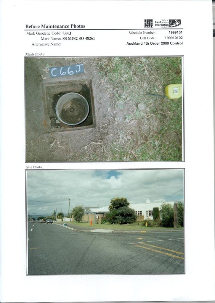
Sorry, I'm not familiar with with what you're talking about. In New Zealand, survey points are sometimes located underneath a manhole. Like this one, which is a pin inside a tube inside a manhole. This would be tagged as survey_point:structure=pin since the pin is the actual survey point. Not sure about your example --Kylenz (talk) 20:00, 14 June 2021 (UTC)Reply
Adding the proposed keys (and values) to the "Proposal Page" template
Latest comment: 4 years ago4 comments2 people in discussion
Hi User:MalgiK, I was a bit confused by that template since it doesn't explain what to do when you have multiple proposed keys and values. Any advice? And I will change the word "node" to "" --Kylenz (talk) 22:09, 15 June 2021 (UTC)Reply
Hi, you are right, the proposal template seems not really suitable for multiple keys and values, maybe at least just via a text form like this:?
{{Proposal Page
| name = Survey Markers
| key = survey_point:structure=beacon/block/pillar/pole/bracket/plaque/medallion/pin/cut, survey_point:condition=reliable/not_reliable/not_visible <!-- The key of the proposed new tag, if relevant -->
| value = <!-- The value of the proposed new tag, if relevant -->
| type = {{IconNode}}
| definition = The structure and condition of a survey marker.
}} --MalgiK (talk) 02:24, 16 June 2021 (UTC)Reply
Latest comment: 4 years ago5 comments2 people in discussion
Resolved
Hello! I'm currently not sure about how broad the definition of "survey_point:structure=pin" is supposed to be. Are there any constraints in size or whether there is an indentation to insert survey instruments?
Hi, yes at the moment survey_point:structure=pin is a bit broad, I don't think we need a size limit, do we? Maybe it would be useful to use diameter=*. I'm not sure how you could express that there is an indentation to insert survey instruments - any ideas/suggestions? --Kylenz (talk) 22:47, 15 June 2021 (UTC)Reply
Personally I don't think there's need to include strict constraints regarding size in any of the types or markers, so using diameter=* should be fine. However, I'd argue that it would be good to be able distinguish the markers as shown in the images I've included above (especially 1 in contrast to 2 in contrast to 3/4). This could be done by either having an additional value for survey_point:structure with 1 and 2 each having a different value from 3/4, or alternatively by introducing a new key for whether there's an indentation and of what type it is, which would be nice to have included in this proposal but not a necessity. I don't have a strong opinion which option is better, so I suppose it's up to you whether you see the need to include this in your proposal. --Nw520 (talk) 17:46, 16 June 2021 (UTC)Reply
In such a situation, is the survey marker related to the pole itself or does the pole is used as a common support?
You're probably dealing here with supported features on a single OSM node (a sign on a pole, a light/camera on a pole, a clock on a wall, antennas on a mast, whatever). There are plenty of cases like this we can solve with splitting the node in independent features with their own tagging or punctually using namespaces to solve the indetermination (here with survey_point:marker=* for instance to let utility=* related to the pole only). Anyway, it's a flaw in OSM modelisation we spend hard time to handle and find solutions for, proposing a specialized tag instead of using a common one isn't a valid one to me.
Your proposal may require a bit more discussion to get details about different situations you want to tag, survey point on a pole wasn't part of it prior to start the vote. Fanfouer (talk) 10:32, 22 June 2021 (UTC)Reply


 " --Kylenz (talk) 22:09, 15 June 2021 (UTC)


 I have comments but abstain from voting on this proposal. A way too short period of time to evaluate impact of