Zh-hant:建築物

|
| 說明 |
| 用來描述很多不同的建築物,包括房屋, 工廠和廢墟。 |
| 標籤 |
|
|
Tagging
建築物的外圍線條可以是單一建築物或是一整區 (Block)的建築物,可描繪單一不相連的建築物,或是一整排連棟房屋,或是其他複雜的建築物體。比較好的方式是畫一系列的有共同的點和線的線條來表示個別建築物體。
除此之外,線條可以表示簡單的形狀或是比較精細的建築物外圍。先把建築物簡單標出來,然後再去添加精細的線條和分隔出個別建築物體,是滿常見的方式。
建築物可以標為 building=yes,或是直接描述建築物的種類,例如 building=house, building=hut, building=garage, building=school. 比較完整的案例選項見 building=* 和 have a look at what is actually used。
建築物的地址也可以加上去。地址可以直接加在建築物的外圍線上,或是更常見的方式是加在主要出入口處,那個出入口處用一個點標示 entrance=yes 或是 entrance=*。
有眾多不同出入口複合用途的大型公共建築物,建築物出入口也可以標示為 access=*。一棟建築物的出入口可以連結到一行人走道 (標示為highway=footway 和 highway=steps 等等)。如果有不同的出入口,個別出入口也可用不同的地址標示。
Mentionable usage
There are structures tagged as buildings which are missing a foundation or are even moveable. For example many mappers are using the key building=* to describe moveable objects and buildings for example building=static_caravan, building=houseboat or trailers. While houseboats (often self propelled), ships (for example museum or theatre ships) or docks may be moved once, there are also building=floating_homes which are built on floating logs and do net get moved. Some mappers are additionally using floating=yes to indicate this property.
Differing from the ideal of mapping the outline of a building on the ground, many objects with building=* include parts of buildings (for example constructed on piers) which are only covering areas. building=roof and building=bridge even describe buildings which have, except its piers, no outline on the ground. The same holds for underground buildings like building=cellar or those building types which are tagged with location=underground.
Don't tag for the renderer
- 更多此主題的細節、見 Tagging for the renderer。
Some mappers are trying to modify OSM data to be rendered (e. g. by Mapnik) in a way to fit their wishes by creatively reinterpreting some existing tags.
Please map all attributes as close to the reality as possible with the available data. Make use of the descriptions for the tags at the refering wikipage. Use the existing values by its definition at the wiki and choose the best fitting pair of key and value. If there is no fitting tag and no more generic tag, you may find some uncommented already used tags at taginfo. If all of this does not suffice, you may better create a new tagging and document it at the wiki.
Here are some negative examples in context to buildings.
- tagging of non existing
amenity=*to emphasize the building at the rendered picture - modify/omit tagging due to dissatisfaction (e.g. cafe/restaurant)
- building parts as distinct objects to structure the rendered picture
- deleting/moving objects to obtain a (nicer) placement of the icon
- tagging statues, bridge piers, gravestones, sockets, ships as buildings to make them visible on the map. This can be counterproductive even for 3D-Mapping.
Such manipulations damage not only the OSM, but also they are needless, because their effect is usually limited to a single renderer, which will be probably modified soon.
If there are substantial rendering errors, please contact the developers of the renderers directly.
How to map
When tracing from aerial imagery try to estimate the place where the building position on the ground which may be offset from the roof-line as shown by the imagery on the far side given that images are normally taken from an angle.
If the building has an interior courtyard the use a Multipolygon relation to ensure that the courtyard is not rendered as part of the building.
entrance=yes(if you know where the entrance is)addr:street=*addr:housenumber=*addr:postcode=*addr:city=*addr:country=*
- (more values and detailed information here: Key:addr)
- ITO Map has a layer to help track building address details
- OSM Inspector is also able to help in checking these tags
in JOSM
- As a lot of buildings are rectangular, you can draw a rough rectangle, and then orthogonalize it in JOSM with the hotkey Q. Pressing Q on a selection sets all the angles in the selection to be 90°. Be sure you're using a projection like Mercator, otherwise if you use something like WGS84, then objects will be distorted when rendered. (Please be aware that not all buildings are orthogonal and sometimes it is better to keep an odd looking polygon instead of making a curved shape rectangular.)
- JOSM/Plugins/BuildingsTools makes mapping of buildings a lot more convenient (hotkey B). This works best for buildings with four nodes.
- JOSM/Plugins/Terracer is for quickly mapping a row of terraced houses.
in Potlatch
In Potlatch, you can add several buildings quickly especially in residential areas by tracing the building with one hand with the mouse and then with the other hand pressing the 'R' key to add the properties of the previously selected building. Add the source, building tag and whatever other tag you want on the first building then copy it to the other buildings.
Some ways to get the outline of the building
- Aerial photographs (e.g. Bing). There are also some tips and tricks for roof modelling.
- Observations from street level, drawing a sketch, or even taking measurements
- Walking around the edge of the building taking a GPS trace. Good enough for big buildings (e.g. a stadium) but walls normally reflect the GPS signal, causing the trace to be offset a significant distance away from the building.
- French Cadastre
See also
shop=*to indicate that the building is used as a specific shopamenity=*to describe what the building is used for, for example: school, theatre, bank, ...entrance=*to mark the entrances to the buildingman_made=courtyardproposed tag for courtyardsarchitect=*to indicate the architect of a buildingbuilding:condition=*for the condition of the buildingruins=*- for ruins of buildingsabandoned=*- for a building which has been abandoned by its owner and is no longer maintainedstart_date=*- the year of construction
3D
Use the Simple 3D buildings that is already implemented in some tools and offers backwards compability with previous approaches.
Proposals
- Proposed features/Building - original proposal, which mentions various other ideas
- Proposed features/Building attributes - attributes proposal, cancelled
- Relations/Proposed/Buildings - (to group buildings and other related things together)
Examples
-
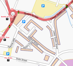
![Sutton Coldfield rendered in the 'standard' style ([1]) as it was back in 2008 (buildings have since been made less bright coloured)](/w/images/a/ab/Rendering-area-building-yes.png) Sutton Coldfield rendered in the 'standard' style ([1]) as it was back in 2008 (buildings have since been made less bright coloured)
Sutton Coldfield rendered in the 'standard' style ([1]) as it was back in 2008 (buildings have since been made less bright coloured) -
 Sutton Coldfield rendered by osmarender (the old tiles@home map style)
![Sutton Coldfield rendered in the 'standard' style ([1]) as it was back in 2008 (buildings have since been made less bright coloured)](/wiki/File:Rendering-area-building-yes.png)
