Proposal:Key:is sidepath
| is_sidepath | |
|---|---|
| Proposal status: | Proposed (under way) |
| Proposed by: | Chris66 (initial draft), Supaplex030 (further development), tordans (support) |
| Tagging: | is_sidepath=*
|
| Applies to: | |
| Definition: | To indicate whether a way (particularly a cycleway or footpath) runs parallel to a street, making it adjoining, or runs separated and thus detached from the road. |
| Statistics: |
|
| Draft started: | 2015-08-23 |
| RFC start: | 2022-12-02 |
Proposal

is_sidepath=yes).The tag is_sidepath=* is proposed as an additional tag on ways, particularly cycle ways or footpaths, to indicate whether the path runs parallel to a street (roadside), making it adjoining, or runs separated and thus detached from the road (isolated).
Note: A previous version of this proposal suggested additional subtags which were moved to a separate proposal based on the RFC feedback and are no longer part of this proposal.
Rationale
Roadside paths and ways can be mapped separately in OSM. These separate geometries cannot be identified as part of the road, or only with significant effort using geometric processing (which fails in many edge cases). Most applications cannot afford such complex calculations.
However, the information about whether a path is adjoining to a road or not is crucial for many use cases and offers various advantages:
Improved Data Analysis:
- Whether a path or way is roadside is one of its essential characteristics.
is_sidepath=*thus enables a more precise classification of ways. - Analyses, such as evaluating the quality of footway or cycle path networks, benefit from the ability to identify separately mapped roadside paths or to distinguish between roadside and isolated paths.
Improved Rendering:
- Depending on the map style, roadside paths can be displayed differently (e.g., thicker, thinner, or not at all, with or without a name, etc.).
- Due to the over-wide representation of generalized rendered roads, their sidepaths are sometimes hidden, which can be more easily prevented with clear sidepath attribution.
Improved Routing:
- Routing directions can be significantly enhanced by incorporating road attributes like the road name (e.g., "Follow the cycle path along road XY").
- Routing profiles can more easily incorporate road classifications in the route calculation (e.g., avoid major roads, prefer minor roads).
So far, there is no approved concept in OSM to record such sidepath situations. However, some applications already use this tagging to benefit from the mentioned advantages (see below). While there are alternative approaches to this issue in OSM, they are not practical for large-scale use for different reasons (see the section on alternative concepts and their limitations).
Tagging
Add is_sidepath=* to a way tagged with highway=*, particularly when it's a highway=cycleway, highway=footway or highway=path, using one of the following values:
yes: The way runs adjacent and parallel to a road.no: The way provides an independent route.
On sidewalks mapped as footway=sidewalk the information is considered implicit and as such is_sidepath=yes is not necessary.
This tagging should not be used on a road itself. However, it can be useful to use this tagging on other types of ways beyond the named situations, for instance highway=bridleway. For ways intended for motorized traffic (like highway=service or highway=busway), some mappers use side_road=* for similar purposes.
Examples
Typical examples for different types of ways and situations
All examples assume that the shown path is mapped separately.

|
Cycle track along a main road near Morpeth, UK (OSM): |

|
A meandering sidewalk along 12th Avenue in Hanford, California (OSM): |
|
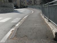
A sidewalk located directly at the edge of the road: |

|
Cycleway along and adjacent to a street in Wroclaw, Poland (OSM):
There is also a footway (but not a sidewalk in the strict sense), separated by trees, that's a sidepath of the same road (OSM): |
|
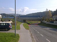
Footway delimited by a (functionally determined) wider green strip in Gratkorn, Austria (OSM):
|
|
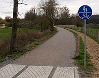
An isolated cycle and footpath without any relationship to a road (OSM):
|
Edge Cases: When it's a sidepath and when it's not?
It is not always clear whether a way should be categorized as a "sidepath" of a road or not. Ways that run parallel to a road can sometimes be directly adjoining to the road, while in other instances, they may run somewhat away from the road. Occasionally, they are far apart from the road, leading to interpretation as an independent path. In some cases, a way may be nearby a road but with no direct relation to it due to an obstruction between the way and the road. Additionally, the way may not run parallel to the road, further complicating the distinction.
To help categorization in such edge cases, there are some criteria that characterize a sidepath (is_sidepath=yes):
- The path or path segment runs along and parallel to a road (e.g., "XY Road").
- The path is located close to the road, making the road and its traffic clearly perceptible from the path.
- When using the path, one would describe movement as "along XY Road" for the footway/cycleway.
Therefore, the simplest rule of thumb for classifying a way as a sidepath is: If you are moving along the way, would you say you are moving "on a way along road XY"?
Two examples might help distinguish:

|
The path runs on an elevation parallel to a road, with a 15 meter wide green strip containing shrubs and trees in between (enlarge the image for a better view or see the path on OSM). Despite this green strip, the road and its traffic are clearly perceptible from the path that runs alongside the road for a longer stretch. If a navigation system instructs to move along the road, it is evident which road is meant.
Therefore, it is rather a sidepath: |

|
The path runs parallel to a motorway, which is elevated at some distance and behind a noise barrier. Further along the path, there is a dense row of trees in between, with an access road to the path on the ramp visible. The road traffic is hardly perceptible on the path; instead, the path is characterized by the adjacent vegetation in the further course. Navigation instructions such as "follow the path along the motorway" might lead to misunderstandings.
Therefore, it is rather not a sidepath: |
Note: For example in German traffic law there are administrative regulations according to which a path is "part of" a road within a distance of 5 meters (or is not part of the road if its located more than 5 meters away).[1] However, this is a legal assessment that does not necessarily correspond to the actual perception on the ground and should therefore not be decisive for OSM tagging.
Illustrations: How to use sidepath tagging at intersections?
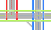
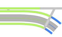
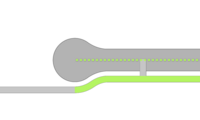
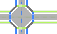
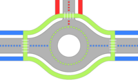
At intersections, sidepaths of different roads can converge. In such situations, it is not always clear to which road a sidepath belongs or whether a path is a sidepath or not. The following schematic illustrations demonstrate how sidepath tagging can be applied. Different colors indicate the relationship between the highway centerlines and "their" sidepaths.
![]() Carriageway
Carriageway
![]() Crossing
Crossing
![]() Highway centerline
Highway centerline
![]() Tagged
Tagged is_sidepath=yes (or alternatively footway=sidewalk, depending on the situation) (can be assigned to a parallel road)
![]() Tagged
Tagged is_sidepath=yes (or alternatively footway=sidewalk, depending on the situation) (cannot be clearly assigned to a parallel road)
![]() Tagged
Tagged is_sidepath=no
In these intersections, the red, blue, and green paths are adjoining ( |
In these intersections, all paths are adjoining, so |
Current usage
By mappers
This tagging emerged in 2014 and was initially used by some individual mappers in Germany for some years. Since the beginning of 2021, this tagging has seen a strong increase in use after it was mentioned on some community channels and wiki pages and is now used by several users mainly in Europe and the US so far.
By applications
- cycle.travel uses this tag to determine whether a cycleway is a roadside cycleway, and if so, to influence the turn-by-turn directions generated for a given route.
- The NUDAFA-Project (Website) used the tag to better process bike related infrastructure (Github) to create maps that are used for bike network planning.
- The Radverkehrsatlas uses the tagging to categorize bicycle infrastructure.
- The OSM Berlin Tagging Recommendation for mapping sidewalks, crossings and cycleways is using this schema.
- The OSM Cycling Quality Index is using this schema to categorize bicycle infrastructure.
Alternative concepts and their limitations
footway=sidewalkis an established concept to specify the same thing asis_sidepath=yes. This proposal does not change anything for this tag but instead definesis_sidepath=yesto be implicit wheneverfootway=sidewalkis used.cycleway=sidepathis an alternative tagging method, alsofootway=sidepathandpath=sidepathare suggested. However, there may be a conflict betweenfootway=sidepathandfootway=sidewalk, becausesidewalkrefers to a specific part of the road that (depending on the definition) might not apply to everysidepath. Moreover,cycleway=*,footway=*andpath=*are already used by mappers to distinguish between different types of ways (e.g.footway=crossing/sidewalk/access_aisle/link...,cycleway=crossing/lane/track/link...path=crossing/desire/hiking/climbing_access/link...) of which some may also be sidepaths. It's also not possible to explicitly identify a way as isolated/not a sidepath. It therefore seems necessary to use a distinct tag to classify sidepaths.
- In the wild, there are many other tags that are rarely in use and often have an unclear meaning, but probably also imply a meaning like
is_sidepath=yes, such ascycleway=sidewalk,path=sidewalkorcycleway=trackin combination withhighway=cycleway. Apart from the lack of a systematic approach, the problems mentioned above also apply here. - Street relations are another method that allows to identify paths "belonging" to a street. In practice, however, street relations are very rarely used. Editing relations is a major hurdle for most mappers and is only supported by a few editors. They require a very high effort for data recording and maintenance and experience shows that such relations are not maintained properly. In contrast, the use of a "relational" tagging schema is much simpler. The example of addresses shows that the use of relations does not succeed for frequent features (we use
addr:*=*-tags instead of associatedStreet relations).
- Germany/Workshops/Linienbündel was an very early (2008) attempt to group separate ways with some ideas and suggestions that were not realized.
- The
area:highway=*schema could be helpful with grouping ways that are part of the same "street corridor", but for physically separated ways where thearea:highway=*areas have no shared edges, this approach is limited. A presentation at SOTM 2019 by Martin Lucas-Smith (CycleStreets) outlines a similar "street concept" using areas enclosing streets and their side paths. Apart from the high effort of mapping such areas, however, there is no practical realization so far and it is unclear how such areas would relate toarea:highway=*, for example. Some mappers might uselanduse=highwayin this manner, but there is no consensus on how to use this tagging, what this area should enclose and where it extends, or what happens in cases of conflicts with other landuses, on bridges or tunnels etc.
Features/Pages affected
- Add the information and examples from this proposal on
is_sidepath=*page. - Add notes and references on pages like Key:footway, Bicycle, Tag:highway=cycleway and other related pages.
- Add a reference on Tag:cycleway=sidepath (see above).
- Suggest additions for the common editors, like additional fields to the iD Tagging Schema project.
Note: Most of those pages have a reference to this proposal already which needs to be updated as well.
External discussions
- RFC discussion (Community Forum, Tagging Mailing List) on the first version of this proposal from the end of 2022.
- Review of the is_sidepath concept from the perspective of A/B Street and osm2streets, OSM-based projects with complex requirements for the processing of road data and lane attributes.
- Extensive community discussion during the FOSSGIS Community Meetup in 2023.
- Extensive community discussions and experimentations in various OSM Verkehrswende meetups.
Comments
Please comment on the discussion page.
