Tag:junction=roundabout: Difference between revisions
(→Ref Tagging: remove tagging for renderer, reword recs) |
(→How to map: Structure "How to map section", remove repetitions) |
||
| Line 56: | Line 56: | ||
== How to map == |
== How to map == |
||
[[File:Draw roundabout using iD.gif|thumb|Short tutorial showing how to draw a roundabout using the iD editor (click on image to start animation).]] |
[[File:Draw roundabout using iD.gif|thumb|Short tutorial showing how to draw a roundabout using the iD editor (click on image to start animation).]] |
||
Start by drawing a circular shape, which would represent the roundabout. Furthermore: |
|||
| ⚫ | |||
| ⚫ | |||
* Give it a name only if is official or displayed (generally it is different from the name of highways connecting or passing though them, but many of them remain unnamed as it is undecidable between these competing highways, and because there's no address for residents located inside, or because addresses are given to one of the connecting highways: only large roundabouts have a dedicated name). |
|||
| ⚫ | * |
||
| ⚫ | * |
||
| ⚫ | * |
||
* Again, a roundabout should only be tagged with {{Key|name}} if the junction itself is named independently and differently from the roads crossing it. |
|||
* Each road has to be connected with the roundabout in a separate node—that is, between these nodes a segment of the roundabout is required. Thus routers can safely recognise that a section of the roundabout has to be driven through. You should always be able to trace it; if not, that's because you did not trace the roundabout within its most external lane where vehicles can enter and exit the roundabout and should increase its radius a bit more by moving nodes on interconnection nodes and using the "make circle" tool in your editor to regularise it. |
|||
| ⚫ | |||
[[File:Roundabout-tagging.png|640px]] |
[[File:Roundabout-tagging.png|640px]] |
||
=== The roundabout itself === |
|||
* '''Shape:''' Most editors have a tool to create a circle. (see below) |
|||
| ⚫ | |||
* '''Where exactly:''' Either on the middle of the outermost lane or on the middle of all lanes. The best option is case-dependent. Use your own judgement. If in doubt, it makes sense to check for nearby similar roundabouts that have already been mapped and adopt their style. Pros and cons are: |
|||
** Mapping the outermost lane. Pro: Makes it easier to leave a segment between adjacent entries and exits. Con: Entries/exits may become distorted if they have >1 lane. |
|||
** Mapping the middle of the road: Pro: Less distortions, the mapped shape better reflects reality. Con: If adjacent entries/exits are close to each other, it will become tricky to leave a the required segment between them (see below). |
|||
* '''Tags:''' |
|||
| ⚫ | |||
** {{tag|oneway|yes}} is implied and redundant. It is not wrong to add it explicitly, though. |
|||
| ⚫ | ** It may be useful to tag the number of {{Tag|lanes}} in the ring (typically 2, where long vehicles will need to use both; 1-lane roundabouts are especially important to tag if they exist for large, but usually roundabouts the second lane, or are transformed to miniroundabouts whose central island is not blocking but can be used at very slow speed by long vehicles). |
||
** '''Name:''' |
|||
*** Give it a name only if is official or displayed. Generally, the name of the roundabout is different from the name of highways connecting or passing though them. |
|||
*** In many cases, the roundabout remains unnamed as it is undecidable between the competing connecting highways. However, large roundabouts may have a dedicated name. |
|||
*** If there exist a postal addresses for residents located inside or around the roundabout which is different from the connecting highways, then this is usually the name of the roundabout. |
|||
=== Connecting ways === |
|||
* '''Connect''' the approaching roads/ways with the roundabout. |
|||
* '''Split:''' |
|||
** If a road is split into two separated carriageways (one approaching, one departing), draw those explicitly and tag these carriageways with {{Key|oneway|yes}}. Pay attention to their correct orientation. |
|||
| ⚫ | ** Sometimes the split is only because of a [[Tag:junction=roundabout#roundabout_flare|roundabout flare]], a small island not used by pedestrians or bicyclists for crossing. In this case there is no split needed, it is sufficient to set a separate node (not the node where the way is merging into the roundabout) tagged {{Tag|traffic_calming|island}}. |
||
** Do ''not'' split the roundabout itself. |
|||
* '''Nearby approaching and departing roads:''' Do not connect approaching and departing roads. A segment of the roundabout is required between these roads. This way, routers can safely recognise that a section of the roundabout has to be driven through. |
|||
* '''Tags:''' |
|||
| ⚫ | ** Tag the roundabout and approaches with {{Key|highway}}, the same as the connecting roads. If there are several roads of different importance connecting to the roundabout, you should usually use the one with the greatest importance, that does not begin/end at the roundabout. See [https://wiki.openstreetmap.org/w/index.php?title=Tag:junction=roundabout&action=submit#Selection_of_the_right_highway_tag Selection of the right highway tag]. |
||
** Tagging the number of {{Tag|lanes}} (typically only one in many roundabouts) on one-way approaches will be useful. |
|||
** You may tag nodes where vehicles stop to give way to vehicles already driving in the ring. |
|||
=== Central island === |
|||
| ⚫ | |||
=== Editor support for circles === |
=== Editor support for circles === |
||
Revision as of 11:31, 5 December 2020
 |
| Description |
|---|
| A road junction where the traffic goes around a non-traversable island and has right of way. |
| Group: highways |
| Used on these elements |
| Implies |
|
| Useful combination |
|
| See also |
| Status: de facto |
| Tools for this tag |
|
A roundabout is a generally circular (self-intersecting) road junction where the traffic on the roundabout has always right of way.
The tag junction=roundabout is used only on road intersections where traffic on the roundabout has right of way.
That is, the roundabout itself should be free from all intersection controls including traffic signals, stop signs or stop markings, give-way (or yield) signs or give-way markings. However there exists exceptions in some roundabouts in some cases where there's a special service way passing through the island, reserved to buses/tramways/emergency vehicles (which will have priority to the normal traffic, and for which there may be traffic signs requiring vehicles on the ring to give the way; in normal times these giveways and traffic signals are off).
Where traffic does not have right of way, this is a rotary (also called traffic circle). The tag junction=circular should be used on rotaries.
The size of a roundabout can vary from small to very large with several lanes.
Naming

Only if the roundabout itself has a name, the name=* key is applied (such as John's Junction). It should not use the name of a road it connects.
If the roundabout does not have an individual name, the name=* tag is not used.
Ref Tagging

For roundabouts that have ways either continuing through, or ending at the roundabout, ref=* and int_ref=* tags from those ways should be added to that roundabout if roundabout is also part of that routes.
Ways connecting to the roundabout

Each way which intersects with the junction=roundabout should be connected to it with a separate node.
Two ways which enter and exit a roundabout should never connect to the same node on the roundabout.
This is required to allow routing applications and software to provide correct directions, otherwise the routing software will not correctly recognise the roundabout, interpreting it as a simple junction.
Roundabout Flares

Often roads connecting to the roundabout widen around a splitting island. This feature is called a roundabout flare. For small ones, there is no need to split the road in OSM, it is sufficient to set a node tagged traffic_calming=island.
Misclassification
Please pay attention to the section “Possible misinterpretations” to differentiate between:
- Roundabouts (junction=roundabout)—where traffic on the roundabout has always right of way;
- Rotaries and traffic-circles (junction=circular)—where traffic on the rotary does not have always right of way;
- Mini roundabouts (highway=mini_roundabout)—used only on nodes, as a roundabout where the centre of the roundabout must be traversable;
- Turning circles (highway=turning_circle)—used only on nodes, including cul-de-sacs; and
- Turning loops (highway=turning_loop)—used only on nodes, where a road island or similar feature is present.
How to map


The roundabout itself
- Shape: Most editors have a tool to create a circle. (see below)
- Direction: The way(s) must be drawn in the direction of traffic flow.
- Where exactly: Either on the middle of the outermost lane or on the middle of all lanes. The best option is case-dependent. Use your own judgement. If in doubt, it makes sense to check for nearby similar roundabouts that have already been mapped and adopt their style. Pros and cons are:
- Mapping the outermost lane. Pro: Makes it easier to leave a segment between adjacent entries and exits. Con: Entries/exits may become distorted if they have >1 lane.
- Mapping the middle of the road: Pro: Less distortions, the mapped shape better reflects reality. Con: If adjacent entries/exits are close to each other, it will become tricky to leave a the required segment between them (see below).
- Tags:
- Tag the OSM way(s) of the roundabout with junction=roundabout.
- oneway=yes is implied and redundant. It is not wrong to add it explicitly, though.
- It may be useful to tag the number of lanes=* in the ring (typically 2, where long vehicles will need to use both; 1-lane roundabouts are especially important to tag if they exist for large, but usually roundabouts the second lane, or are transformed to miniroundabouts whose central island is not blocking but can be used at very slow speed by long vehicles).
- Name:
- Give it a name only if is official or displayed. Generally, the name of the roundabout is different from the name of highways connecting or passing though them.
- In many cases, the roundabout remains unnamed as it is undecidable between the competing connecting highways. However, large roundabouts may have a dedicated name.
- If there exist a postal addresses for residents located inside or around the roundabout which is different from the connecting highways, then this is usually the name of the roundabout.
Connecting ways
- Connect the approaching roads/ways with the roundabout.
- Split:
- If a road is split into two separated carriageways (one approaching, one departing), draw those explicitly and tag these carriageways with oneway=yes. Pay attention to their correct orientation.
- Sometimes the split is only because of a roundabout flare, a small island not used by pedestrians or bicyclists for crossing. In this case there is no split needed, it is sufficient to set a separate node (not the node where the way is merging into the roundabout) tagged traffic_calming=island.
- Do not split the roundabout itself.
- Nearby approaching and departing roads: Do not connect approaching and departing roads. A segment of the roundabout is required between these roads. This way, routers can safely recognise that a section of the roundabout has to be driven through.
- Tags:
- Tag the roundabout and approaches with highway=*, the same as the connecting roads. If there are several roads of different importance connecting to the roundabout, you should usually use the one with the greatest importance, that does not begin/end at the roundabout. See Selection of the right highway tag.
- Tagging the number of lanes=* (typically only one in many roundabouts) on one-way approaches will be useful.
- You may tag nodes where vehicles stop to give way to vehicles already driving in the ring.
Central island
- You may optionally trace the central island itself, if the roundabout is large enough. This is usually the case if it is bordered by barriers or kerbs, or if it includes significant features such as trees or decorating plants, or a fountain or monument.
Editor support for circles
JOSM
There exist two ways to draw a circle in JOSM:
- Draw a closed way and press the key 'o' or select Tools -> Align Nodes in a Circle in the menu
- Select two or three nodes (e.g. ending nodes of ways leading to a roundabout) and press 'shift-o' or select Tools -> Create Circle in the menu
There is also the JOSM/Plugins/RoundaboutExpander that can help you draw a roundabout in just a few clicks/shortcut presses.
Potlatch 2
In Potlatch 2, draw a closed way with at least three nodes and use Align in a Circle in the toolbar.
iD
In iD, first draw a closed way. Then select the way and press the key 'o', or select the way and click the button that has an image of a closed way on it (labeled "Make this line circular" when you hover over it) in the curved grey contextual menu.
Examples
Signposts
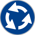
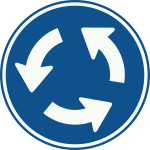
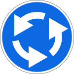
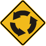
Roundabouts are usually indicated by signposts, like e.g. one of these:

United Kingdom

Germany

Czech Republic
- Belgium-trafficsign-d5.svg
Belgium
Italy
Netherlands

Ukraine
Russia

Japan

Poland
- Fr-AB25-sens giratoire.gif
France

Spain

Portugal

Israel

Singapore

Australia

Québec

United States

Colombia
Peru

Argentina
- A-12.gif
Brasil

Ireland

Iran


For larger roundabouts, sometimes different signage is used (e.g. plain yield signs). As long as the main principle - the traffic on the roundabout has right of way - is maintained, this is acceptable for tagging as a roundabout.
For larger roundabouts, multiple signs may be used: as a prior alert (frequently with speed limit signposts) along highways before entering the disjunction area, just at end of highways where a giveway priority must take place (with sign posts and/or painted marks on the floor through the highway, and on the traffic island itself. Additional signs on the central islands (possibly with flashing lights) may also explicitly signal the required change of direction and will help detect the island from longer distance to reduce the risks of collisions. As well directional postsigns may indicate the only oneway directions to follow at end of highways (generally oblique arrows pointing down to the mandatory lane), where lanes are diverging, to signal the presence of a separator island.
Roundabouts
The following table shows a selection of classical roundabouts: they all are one-ways with a non-traversable center island, and the traffic within the roundabout has right-of-way. For the determination of the correct highway=* see the next section.
|
|

|

|

|
highway=* junction=roundabout |

|
|---|---|---|

|

|

|
Selection of the right highway tag
The following examples focus on the determination of the correct highway=* for the roundabout and therefore only this tag is listed. When tagging a roundabout, junction=roundabout always has to be specified.
| Image | Highway tag | Assumption | Description |
|---|---|---|---|

|
highway=trunk | A dual carriageway trunk passes through the roundabout with two unclassified roads also connecting to it. | The trunk which passes through the roundabout has the highest importance, and therefore the roundabout itself should also be tagged as trunk. Also use two nodes on each side to connect the trunk to the roundabout - one for each driving direction. |

|
highway=unclassified | A secondary road ends at the roundabout, the other three roads are all unclassified. | The secondary road has the highest importance, but it ends at the roundabout. The unclassified roads pass through the roundabout and therefore the roundabout is also tagged as unclassified. |

|
highway=primary | A primary road connecting from north and west, a secondary road ending east and a service road ending south. | The primary road has the highest importance and does not end at the roundabout. Therefore the roundabout is tagged as primary. |
Possible misinterpretations
In OpenStreetMap we have several tags that describe different circular and widened road features.
- junction=roundabout for roundabouts;
- highway=mini_roundabout for mini-roundabouts;
- junction=circular for rotaries (traffic circles) and other circular traffic that is not a roundabout;
- highway=turning_circle for turning circles;
- highway=turning_loop for turning loops;
- highway=passing_place for road passing places; and
- traffic_calming=island for islands meant to calm traffic.
The major differences between the first four are:
- A roundabout is a one-way street with right-of-way and a non-traversable centre island. There can be traffic light, as long as the circular road has right-of-way when the lights are off.
- A mini-roundabout is a one-way street with right-of-way and a traversable centre island. In particular, large vehicles are allowed to drive across the centre island if otherwise not possible due to their dimensions, i.e. it might be impossible for a large vehicle to drive through a roundabout but possible to drive through a mini-roundabout with the same dimensions.
- A circular junction is a one-way street around a non-traversable centre island, however the circular traffic has not always the right-of-way, it has to yield at some or all incoming roads. This includes traffic circles with such yield regulations as perceived in the United States.
- A turning circle is a widened space on a two-way street without any centre island (or at least a fully traversable island). The absence of a centre island allows also large vehicles to turn around.
Why is it important to follow this tagging guideline if the map looks good even when tagged differently?
The map is not everything. There exist a lot more applications which process our data and these tags have different implications e.g. for routers. So if you tag a small roundabout as a mini-roundabout or a loop at the end of a street as a turning circle, it might look ok on the map but will break other applications. So please don't think of this as annoyance and try to use the most fitting tags in each situation.
The following table presents the preferred tagging for the most common situations and also tries to clarify some ambiguities.
| Photo | Tagging | Remarks |
|---|---|---|
|
|
highway=* junction=roundabout |
A standard roundabout with a large, non-traversable centre island. |
|
|
highway=* junction=roundabout
|
Small, but not a mini-roundabout. Although it is preferred to tag this the same way as a large roundabout, for the sake of simplicity it is acceptable to tag this with a single node with junction=roundabout. In this case the tag direction=* should be specified, as its default value is anti-clockwise when used in conjunction with a roundabout. |

|
highway=mini_roundabout direction=clockwise |
A classical mini-roundabout where the centre is only a painted circle. The tag direction=* should be specified, as its default value is anti-clockwise when used in conjunction with a mini-roundabout. |

|
highway=mini_roundabout |
Large, but a mini-roundabout. The centre island is traversable and without signposts. |

|
highway=mini_roundabout |
Also a classical mini-roundabout with a slightly raised but still fully traversable centre island. |

|
junction=circular |
Traffic routed in a circle, with a large, non-traversable centre island. However the circular traffic must yield for at least one, some or each entering road, thus not a roundabout. |

|
highway=turning_circle |
This photo shows a round place with a traversable island in the middle, but this is neither a mini-roundabout nor a roundabout, but instead a turning circle, which allows large vehicles to turn around. Please bear in mind that a turning circle can have any shape, but never a non-traversable island. |

|
There are no indications of right-of-way, so this is a circular junction rather than a roundabout. There are no one-way indications, so the circular way should be tagged oneway=no. | |

|
This is also a circular junction with traffic calming. Watch the arrows closely to figure out whether to tag the circular way with oneway=yes or oneway=no. | |

|
or alternatively proposed
|
Obviously a place for vehicles to turn around. But because of the island, it is not a turning circle (which must not have an island), so this should be mapped as a loop. For the sake of simplicity the tag highway=turning_loop on a single node is currently under discussion. |
Special cases
Signal-controlled Roundabouts
Many roundabouts with heavy traffic are modified with traffic signals controlling traffic on the roundabout itself. Traffic joining the roundabout may not have to obey standard rules of priority at some entrances to the roundabout because of the signalling. In many cases some entry roads (those with lighter traffic) on these roundabouts are not signal controlled so that the whole junction still behaves as a roundabout (e.g., http://osm.org/go/eu5aUXR98--). Even when all junctions are signal-controlled, it is suggested that junction=roundabout be retained.
Shapes
Note also that roundabouts are not necessarily circular in shape: there does exist roundabouts that are 0-shaped (oval) or D-shaped (with a straight segment, notably those created on a square whose one side is along an avenue), or slightly 8-shaped (created by assembling two earlier nearby roundabouts, but removing/barring their median junction, which was earlier bidirectional but with their directional lanes in inverted sides compared to normal roads).
Some roundabouts also include one way lateral shortcuts (to be traced separately as normal oneway highways).
Much more rarely some roundabouts include a way crossing them in the middle (usually this way is restricted for buses or trams, with a priority for these vehicles going through this restricted way, or for footways crossing the roundbout, and give-ways barring the main loop of the roundabout to implement this priority of traffic, without placing any traffic light controls, that would no longer make them eligibible as roundabouts that can only work with priorities: if there are traffic lights blocking vehicles on the loop, you should not map any roundabout but standard crossroads and one-way highways for the loop). But most of the time (when the restricted way in the middle is not used by buses or trams, they crossroads are working as roundabouts (with only the priority given to vehicles that are already in the loop, and give-ways before entry in the loop near the end of connectings highways).
Not a roundabout

It is not a roundabout if one of the roads entering the circle has the right-of-way.
In this situation the tag junction=roundabout has to be avoided. These cases should instead have a junction=circular tag applied to their circular traffic.
In addition, the major and minor road should intersect in one node only, typically in an acute angle. An example is the Strausberger Platz in Berlin, Germany. Such junctions can be tagged junction=circular.
In spite of their name, Hamburger roundabouts (w:en:roundabout#Hamburger roundabout), also known as throughabout or cut-through, are not roundabouts. In this situation the tag junction=roundabout has to be avoided strictly. These cases need no specific “junction” key.
Related tags
See also
- Wikipedia article about roundabouts
- UK Highways Agency Design Manual for Roads and Bridges - Volume 6, Section 2, Part 3: Geometric Design of Roundabouts
- US Federal Highway Administration Safety Program - Technical Summary - Roundabouts
- How to change an intersection into a roundabout in JOSM
- Proposal to group the ways and/or nodes comprising a road junction
- Wikipedia article about traffic circles
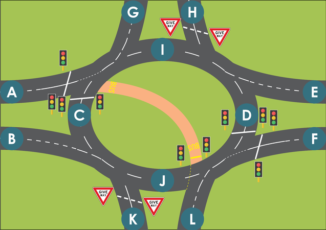
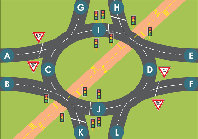
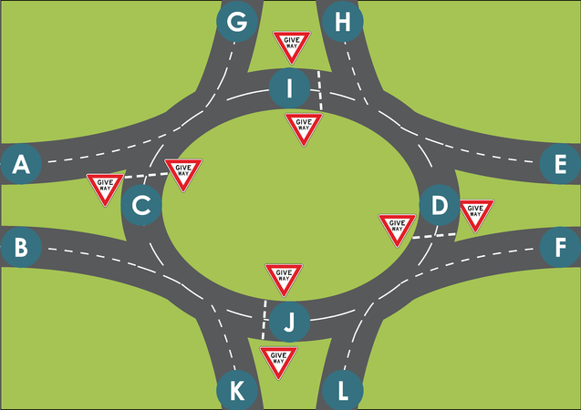
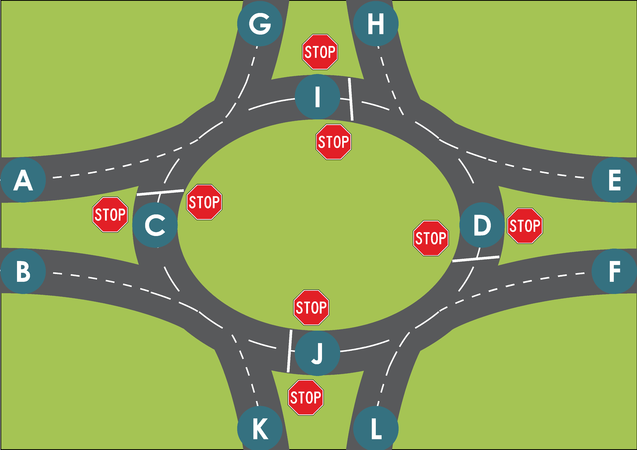
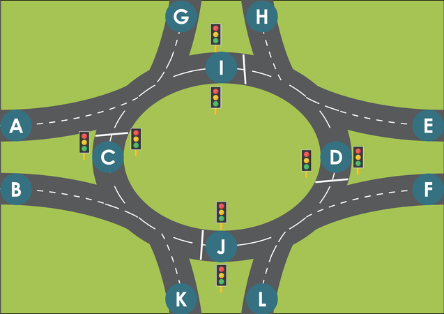
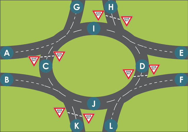
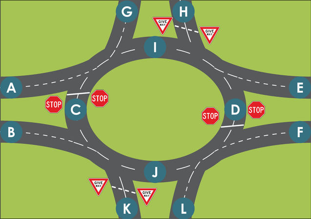
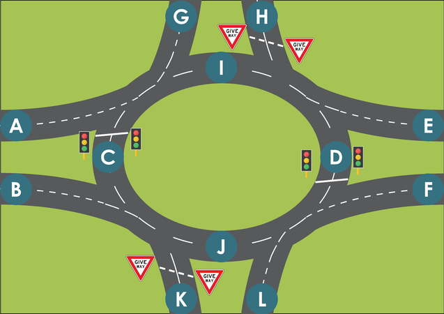
Temporary Gallery of Roundabout Diagrams
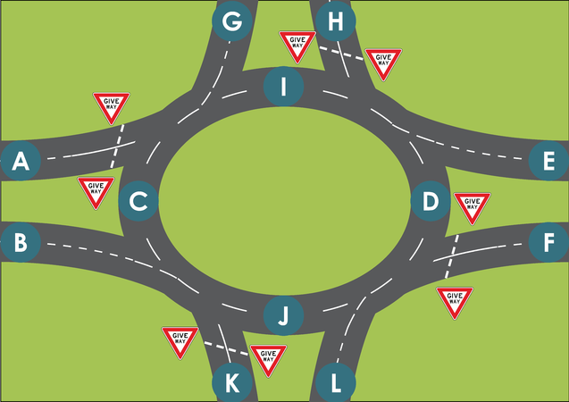
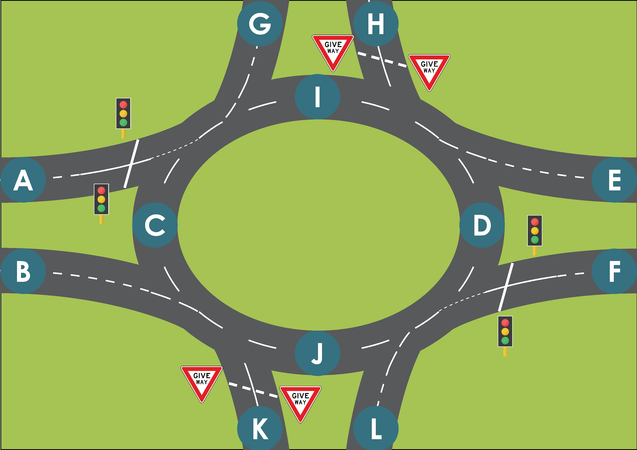
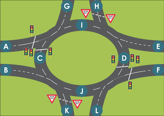
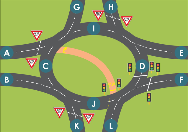
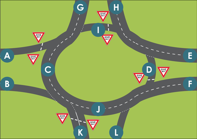
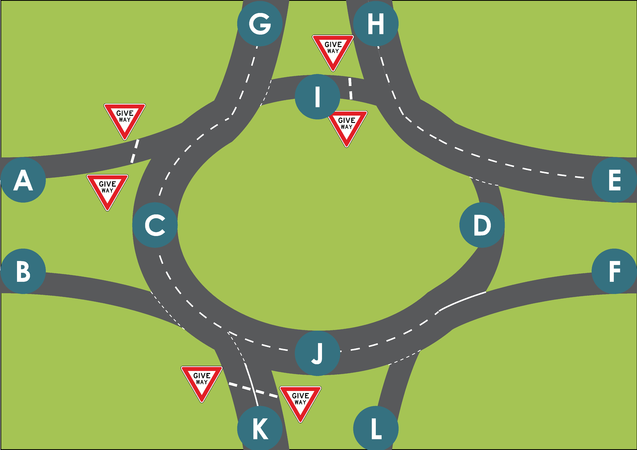
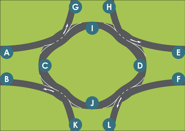
These are roundabouts. They should be tagged with junction=roundabout.
For a junction to be a roundabout all entering roads (Roads A, F, H, and K in diagram) must have a traffic-control (that gives right of way to the traffic on the self-intersecting circular road).
Where roads bisect or cross the self-intersecting circular road at grade level all these roads must also have traffic control (Bus Lane in diagram)
Traffic controls can include Give-Way (Yield) and Stop signs and road markings, and traffic-signals. All traffic control symbols depicted in the below diagram are interchangeable between eachother.
- ALL THESE ARE ROUNDABOUTS (TRAFFIC DRIVES ON LEFT)
CAPTION 1

CAPTION 4
CAPTION 3
CAPTION 2
CAPTION 6
CAPTION 5
CAPTION 7


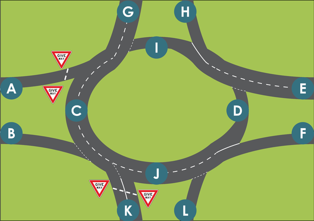
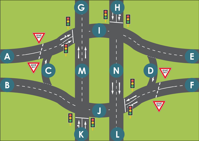
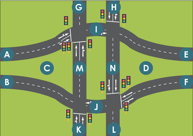
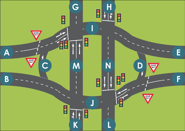
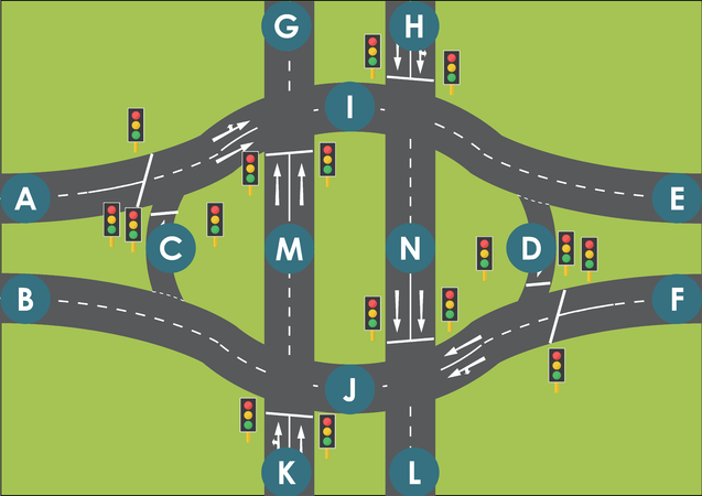
Temporary Gallery of NOT Roundabout Diagrams
These are not roundabouts. They should not be tagged with junction=roundabout. Some of these junctions should be tagged with junction=circular
Note roads A, F, H, K, M and N in diagram which do not have traffic controls.
- ALL THESE ARE NOT ROUNDABOUTS (TRAFFIC DRIVES ON LEFT)
CAPTION 3
CAPTION 2
CAPTION 1
CAPTION 4
CAPTION 5
CAPTION 6
CAPTION 7
CAPTION 8
CAPTION 9
CAPTION 10
CAPTION 11
CAPTION 12
CAPTION 13
CAPTION 14


