Tag:leisure=golf_course
Jump to navigation
Jump to search
| Description |
|---|
| A golf course |
| Rendering in OSM Carto |
| Rendering in OSM Carto |

|
| Group: sports |
| Used on these elements |
| Implies |
| Useful combination |
| Status: de facto |
| Tools for this tag |
|
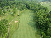
A ![]() golf course is the grounds where the game of golf is played.
golf course is the grounds where the game of golf is played.
How to map
Draw an area around the boundary of the course including clubhouse, car park & any other ancillary features, and tag it leisure=golf_course.
If you are not sure of its border you can place a single node in the middle and tag it leisure=golf_course but the area is preferable.
Tags used in combination
- name=*
- golf:course=* - number of holes
- golf:course=9_hole
- golf:course=18_hole
- golf:par=* - Difficulty of a golf course
- Address
- operator=*
- phone=*
- website=*
- opening_hours=*
Features within a golf course
For details on how to map/tag features refer to their specific pages.
Applies to all features:
- Do not use sport=golf or leisure=pitch.
- Avoid using landuse=* or natural=* tags to indicate its surface, use surface=* instead.
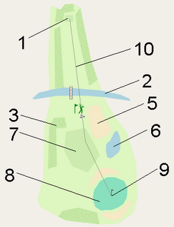
List of features: Key:golf.
| Number | Feature | Element | Description |
|---|---|---|---|
| 1 | tee | An area where play begins on a golf hole. | |
| 2 | water_hazard | A natural obstacle designed to add difficulty to a golf course. | |
| 3 | rough | Areas within bounds which usually have longer length of grass. | |
| 4 | out_of_bounds | Usually defined by white stakes or lines. | |
| 5 | bunker | A type of hazard in the form of a depression in the ground filled with sand. | |
| 6 | lateral_water_hazard | A natural obstacle designed to add difficulty to a golf course. | |
| 7 | fairway | An area between the tee and green where the surface is smooth usually grass is cut even and short. | |
| 8 | green | An area of smooth ground surrounding a pin flag usually of short grass. | |
| 9 | pin | The location of the pin flag. | |
| 10 | hole | A hole is represented by a way along the standard playing path from the tee to the green. | |
| driving_range | A driving range is an area where golfers can practice their golf swing. | ||
| clubhouse | The building dedicated as a clubhouse. Always tag building=* for the building itself. | ||
| cartpath | Path for golf vehicule. |
Common mapping pitfalls
- Adding name=* to objects like name=bunker, name=fairway 1, name=18th Hole, ...
name=* should only be used if an object has a specific individual name and not for generic descriptions. See: Names are not for descriptions. - Adding duplicate ways on top of already existing highway ways and tagging them as golf=cartpath.
- Changing existing highway=* tags to highway=path or mapping new roads as highway=path even if the tag is not appropriate. [1]
- Drawing ad-hoc building shapes that don't resemble the real structures.
- Deleting objects and redrawing them instead of improving the shape. If there is already a hole/fairway/etc. there, update it.
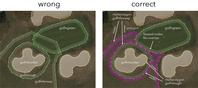
- Wrapping polygon areas around a hole and leaving a tiny open gap. Use multipolygons instead.
- Drawing duplicate water areas to tag them as water hazards, for example 983686015
 983686015.
 - Overlapping green/fairway/rough polygons (see graphic below).
See also: Problematic mapping/golf
Similar tags
- leisure=miniature_golf for a mini-golf/crazy golf centre.
- leisure=disc_golf_course - Disc Golf Course
- leisure=golf_course + golf:course=driving_range - a driving range that stands alone
- leisure=golf_course + golf:course=pitch_and_putt - pitch and putt
- leisure=soccer_golf - Footgolf
- sport=croquet - Croquet
See also
- golf_cart=* For paths for golf carts


