Tag:parking=street_side
 |
| Description |
|---|
| Area suitable or designated for parking which is directly adjacent to the carriageway of a road and can be reached directly from the roadway without having to use an access way. |
| Rendering in OSM Carto |
| Group: parking |
| Used on these elements |
| Requires |
|
— or — |
| Useful combination |
| See also |
| Status: approved |
| Tools for this tag |
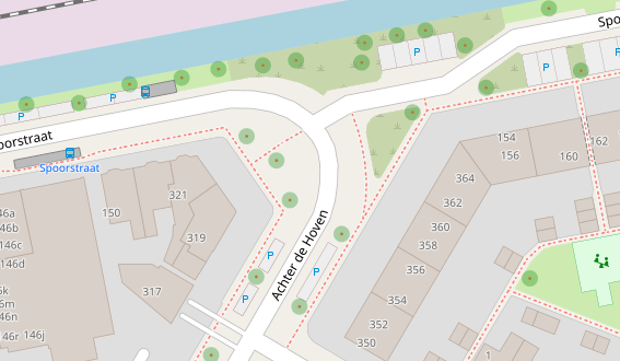
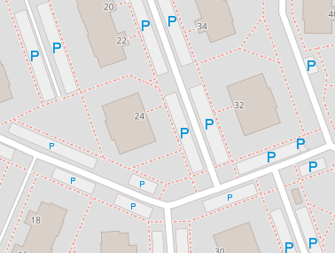
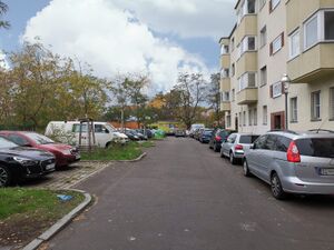
Area suitable or designated for parking which is directly adjacent to the carriageway of a road — either single parking areas (often only for a few vehicles) or chains of "bays" or "pockets" alongside the roadway which, in contrast to parking lanes, are structurally designed and therefore regularly interrupted by structural elements like curb extensions or islands for street furniture. In contrast to parking=surface, these parking spaces are accessed directly from the street without having to use an access/service road or driveway.
Note: For parking lanes directly on the carriageway/at the edge of the road, use parking=lane or the equivalent tags from the street parking scheme at the street centerline. For parking areas on the sidewalk use parking=on_kerb.
See Street Parking for more details on mapping parking along streets.
orientations (parallel, perpendicular and diagonal).Tagging
Street-side parking areas can be drawn as separate areas ![]() using
using amenity=parking (or amenity=motorcycle_parking) + parking=street_side. Consider using the street parking scheme on the highway=* line as a simple alternative if the streetside parking spaces are stretched over a longer section of the road and no micromapping of these areas is desired. The separate variant is particularly suitable in areas where the road space is already mapped in great detail, or if there is only a single (small) street side parking area.
If possible, add the following information in case of separately drawn parking areas:
parking:side=separateshould be added to the highway to indicate that the parking information is already mapped separately on the given side (left,rightorboth, see examples).- The key
orientation=*with the valuesparallel,diagonalorperpendicularcan be used additionally on the separately drawn parking areas to indicate the orientation of the parked vehicles in relation to the street. - It is useful to provide other common information (if identifiable) such as
capacity=*,capacity:disabled=*, orsurface=*. - Parking restrictions can be mapped by using
fee=*,maxstay=*, access restrictions orrestriction=*. See the street parking page for informations about mapping parking restrictions. - Same as with
parking=surface, separate parking places can be drawn in and tagged withamenity=parking_space, but this is optional (Note: Do not useparking=street_sideon these parking spaces if they are already part of a larger area with this tag).
When not to use
Where parking is done directly on the carriageway, consider using parking=lane (or parking:left=*/parking:right=*/parking:both=lane for street parking mapped on the highway line).
For parking lots (i.e., a dedicated area for parking enclosed by a barrier or containing its own service roads) see parking=surface.
Small rest-areas along a road outside built-up areas where drivers can pull over for a brief rest can be tagged with parking=layby.
Examples
 |
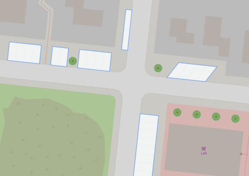
Single street side parking area
On a separate area:
|
 |
Several street side parking areas (on the left – and lane parking on the right)
Variant 1 – with separate area for the streetside parking areas on the left:
Variant 2 – using street parking scheme on highway lines for both sides:
|
Rendering
Rendering in most cartographic styles follows that of other amenity=parking types, such as parking=surface.
In OpenStreetMap Carto, the blue P is rendered slightly smaller than that of larger parking features:
-
Rendering of street side parking in OSM Carto
Relation to area:highway=*
When the parking areas are explicitly mapped using amenity=parking (or amenity=motorcycle_parking) plus parking=street_side, then there is some overlap with the subject of the area:highway=* proposal. Street-side parking mapped with parking=street_side can complement area:highway=* where used.
The relevant proposal shows street-side parking areas mapped as separate areas, which would be a good fit for parking=street_side. Some mappers use area:highway=parking_space to map the area of street_side parking spaces (Note: rarely used area:highway=parking could be better to avoid confusing it with amenity=parking_space). amenity=parking (or amenity=motorcycle_parking) + parking=street_side should be added there as main tag.
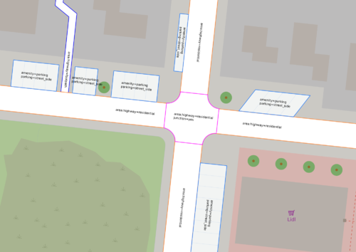
amenity=parking plus parking=street_side, combined with area:highway=*. Other tags such as capacity=* and orientation=* are omitted for brevity.Distinction between street_side and lane parking
Street-side parking bays and areas differ more or less clearly from normal lane parking on the carriageway (parking:side=lane on the street line or parking=lane as separate feature). In general, a street_side parking area is a structural extension at the edge of the carriageway, whereas lane parking is on the carriageway itself.
However, in some cases, a distinction can be difficult and depend on the subjective perception of the mapper. For example, in many places, it is common to extend the kerb at intersections and crossings to slow down traffic and make it safer to cross for pedestrians. Those kerb extensions doesn't make a lane parking of an entire street into a street_side parking. But if there are many kerb extensions in one street, it may become a little hard to distinguish between these two situations in reality.
The following criteria can help to make a classification: they do not have to be fulfilled individually, but can facilitate a categorisation when combined.
Note: When mapping the carriageway width (width=* on the highway line), be aware that the carriageway width includes lane parking areas, but never includes street-side parking areas.
Characteristics indicating street_side parking
Characteristics indicating lane parking
Kerb Extensions
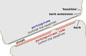
Particularly in combination with kerb extensions (also called "bulb out", "neckdown" and similar), it can be unclear whether a parking area is considered street-side or lane parking. Kerb extensions are traffic calming measures which widens the sidewalk for a short distance to increasing traffic safety for pedestrians.
Kerb extensions are often built into existing road cross-sections. Whether or not this turns a former lane parking into a street-side parking in the OSM sense must be considered in each individual case. The characteristics mentioned above or the following principles can help:
- Large distances between the pavement extensions, the absence of fixed obstacles such as trees, lampposts or bollards as well as an unchanged road surface in the parking area tend to indicate the category of
laneparking. - If, on the other hand, the parking area is divided into rather short sections that are clearly separated from the roadway, this indicates
street_sideparking. - Kerbs form a line that separates the carriageway from the roadside space. Kerb extensions and the parking area in between usually extend out from this "baseline", while street-side parking areas fall behind this "baseline" (see illustration on the right).
Also note the remark above about carriageway width if this is specified at the highway line: For lane parking, the parking area is part of the width value, whereas for street-side parking it's not.
street_side parkings with forward entering and exiting
In some cases, generally for buses or trucks, parking spaces are arranged diagonally from a one-way lane in order to allow easy manoeuvring for long vehicles. Exiting the space is done by driving forward into a second, parallel, one-way lane.
 |
The simplest way to map this is to draw an area amenity=parking + parking=street_side + orientation=diagonal + for example here hgv=designated, and to draw the arrival and departure access lanes in the usual manner with for example highway=service + service=parking_aisle + oneway=yes.
In this case, however:
|
 |
Sometimes, to address this situation and express the fact that both lanes are effectively accessible, a “virtual” lane is added between the entry lane and the exit lane through the first space (the most upstream one). This lane may be tagged |
See also
- Street parking – General informations about how to map parking along streets
parking=lane– Parking on the carriageway, including partially on itparking=on_kerb- Parking outside the carriageway, on a neighbouring footwayhighway=emergency_bay- Emergency bay on a highwayshoulder=*- shoulders, also known as breakdown lanes, often serves as an emergency stopping lanesparking=layby- facility, often rural, alongside a major road where motorists can take a break en-route to their destination
