Tag:amenity=motorcycle_parking
Jump to navigation
Jump to search
 |
| Description |
|---|
| A place which is designated for parking motorcycles. |
| Rendering in OSM Carto |
| Rendering in OSM Carto |

|
| Group: parking |
| Used on these elements |
| Useful combination |
| Status: de facto |
| Tools for this tag |
|
Use amenity=motorcycle_parking tag to identify a designated area for parking motorcycles, used by the public, customers or other authorised users
How to map
Use a node ![]() for smaller motorcycle parks, or an area
for smaller motorcycle parks, or an area ![]() for a larger motorcycle park (but not both for the same facility) and tag it with amenity=motorcycle_parking. If you don't know the actual motorcycle park area or don't have time to draw it out then just tag a node.
for a larger motorcycle park (but not both for the same facility) and tag it with amenity=motorcycle_parking. If you don't know the actual motorcycle park area or don't have time to draw it out then just tag a node.
Tags used in combination
| Key | Value | Description |
|---|---|---|
| name | * | Name of parking. |
| operator | * | Operator of the parking. |
| ref | * | Reference number of the parking lot if any (e.g. "P01"). |
| covered | yes/no | If parking if covered. |
| access | yes/customers/permissive/private | Distinction between public parking lots, customers parking lots (such as at cinemas etc.), and private parking lots (such as for staff in a business park). In this case, yes denotes a public parking lot. The addition of "customers" was disputed for some time (see discussion), but it's widely used now. |
| capacity | * | The number of motorcycles that can be parked here. |
| fee | yes/no | Whether you have to pay a parking fee or not. Default value is no. If the fee must be paid only on certain hours, the same syntax can be used as for opening_hours (see the discussion page). |
| parking | surface | A dedicated area for parking consisting of one level of parking on the ground. |
| multi-storey | Two or more levels of parking decks in a building structure. Please consider adding the appropriate building=* tag, if it is purpose-built for this purpose, building=parking is the most popular value. | |
| underground | Underground parking. | |
| rooftop | One level of a parking deck on top of the building. | |
| sheds | Private hangars for vehicles, located close to owner's home. Usually constructed of profiled metal. | |
| carports | Structure used to offer limited protection to vehicles, primarily cars, from the elements (wikipedia article). | |
| garage_boxes | One level buildings for motorcycles, usually made of brick and metal. Usually this area belong to garage cooperative with own name, chairman, budget, rules, security, etc. | |
| lane | Parking on the carriageway. Can also be mapped using the street parking scheme instead (parking:left, parking:right or parking:both). on_kerb, half_on_kerb or shoulder as well as street_side (see below) are other parking=* values that can be used to specify different street parking positions. | |
| street_side | Area suitable or designated for parking, which is directly adjacent to the carriageway of a road (but not on lane – see above) and can be reached directly from the roadway without having to use an access way. | |
| maxstay | e.g. 30 minutes, 1 hour or 2 hours | Time limit for parking (e.g. customer parking for 2 hours) . |
| motorcycle_parking | * | Details the type of equipment to lock the motorcycle on the parking (e.g. floor, hoops...). |
Types of parking
See main entry: motorcycle_parking.
Photos
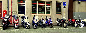
Motorbikes and scooters parked in a designated area without hoops
See also
- amenity=parking
- amenity=bicycle_parking
- highway=service along with service=parking_aisle
- motorcycle:parking=* (to tag an accommodation tourism=* or amenity=restaurant etc.)