Talk:Tag:service=alley
alley are also common in asian cities and villages: see widely use in Taiwan. --Marek kleciak (talk) 05:18, 30 August 2017 (UTC)
Examples in new gallery
Ftrebien - are the new examples in the gallery actually alleys?

Hanway Street, Fitzrovia, Westminster, London

Devonshire Close, Marylebone, Westminster, London

Passage des Arts, Paris

Rosmarinstraße, Mitte, Berlin

.jpg)


They look like narrow residential or commercial streets. Here in North America, an alley will be behind the houses to access garages and services like trash and recycling, and there is another entrance. Are the example streets a service road which is accessing the back of properties? --Jeisenbe (talk) 16:50, 11 February 2021 (UTC)
- They're all mapped as alleys in OSM and have been so for a long time, you can easily verify that yourself simply searching for their names and looking at the edit history. --Fernando Trebien (talk) 17:19, 11 February 2021 (UTC)
- It may also indicate that this specific ways are mistagged in OSM data Mateusz Konieczny (talk) 18:05, 11 February 2021 (UTC)
- How about Spittlertormauer, Nuremberg, Germany? It seems to tick all the boxes: located between properties, provides access to rear entrances, narrow public street in a medieval settlement. --Fernando Trebien (talk) 21:11, 11 February 2021 (UTC)
- I started "Hanway Street - London - highway=residential or highway=service" thread on talk-gb mailing list Mateusz Konieczny (talk) 06:14, 12 February 2021 (UTC)
- While I am an advocate of service=alley for narrow streets in historic towns (not because they have to be historic but because this is where they typically occur), to me these examples all seem quite wide and I would tag them as residential streets. I use the alley tag for streets that are too narrow to accomodate a car and a sidewalk (usually no sidewalks, sometimes not passable by cars due to width). I do not take issue with North Americans having a different idea. The word "alley" is probably older than your cities though ;) (just a joke, no ethymological research was conducted). Here are some examples from Italy and Germany:
- It may also indicate that this specific ways are mistagged in OSM data Mateusz Konieczny (talk) 18:05, 11 February 2021 (UTC)


_02.jpg)


- --Dieterdreist (talk) 00:08, 12 February 2021 (UTC)
- I would say that File:Vicolo Baciafemmine.jpg is highway=steps, tunnel=* (and if it would be flat then it would be highway=footway. File:Gasse Sommerhausen.png seems also to be highway=residential to me. Other seems OK for highway=service is used by motor vehicles (otherwise some of them would rather be highway=footway, possibly with some bicycle=*) Mateusz Konieczny (talk) 06:18, 12 February 2021 (UTC)
- I agree. In particular, Hintere Gasse in Gmünd is very much what I imagine as a narrow medieval way, though it is not public (it is mapped
 mapped with access=destination). So if it were really access=yes, I think it would match what I have in mind as a possible (perhaps desirable) assignment of service=alley. From what I see on the map, it seems to be the main access to several properties, which goes against the idea that alleys should be used only for ways leading to rear entrances or alternative/non-main accesses. In addition, in some places, there are some narrow public ways (considering the entire cross section, including sidewalks if any) in non-medieval settlements where service=alley may be suitable due to significantly reduced mobility relative to the typical nearby highway=residential ways. --Fernando Trebien (talk) 15:02, 12 February 2021 (UTC)
- I agree. In particular, Hintere Gasse in Gmünd is very much what I imagine as a narrow medieval way, though it is not public (it is mapped
- An open question is whether "narrow" means narrow for a car or narrow for a motorcycle. While browsing images of alleys, I saw some with motorcycles and no cars. It is physically possible for a motorcycle to drive on most footways, so I think it would be more useful to define "narrow" as narrow for a typical car. --Fernando Trebien (talk) 19:44, 20 February 2021 (UTC)
- I would say that File:Vicolo Baciafemmine.jpg is highway=steps, tunnel=* (and if it would be flat then it would be highway=footway. File:Gasse Sommerhausen.png seems also to be highway=residential to me. Other seems OK for highway=service is used by motor vehicles (otherwise some of them would rather be highway=footway, possibly with some bicycle=*) Mateusz Konieczny (talk) 06:18, 12 February 2021 (UTC)
- --Dieterdreist (talk) 00:08, 12 February 2021 (UTC)
Conflation of definition based on use vs. width
The Portuguese community has been discussing (and AntMadeira said there have been several discussions in the past about this, which probably should be listed in the page) the current conflation of the concept of an alley as defined by its actual use and access, as opposed to merely narrow/old streets. In particular, the following passages currently in the page:
- "Old, narrow streets that provide access to the main entrances of buildings are also mapped as alleys, to distinguish from wider streets which are instead mapped as highway=residential."
and
- "In some (e.g. medieval European) settlements alleys may be the very narrow streets which run in-between buildings, providing public (often through-)access. These may be mapped using service=alley."
...introduce some ambiguity in the definition of what should be mapped as an alley. Given that we already have narrow=yes, what is the rationale to use service=alley rather than e.g. highway=residential+narrow=yes?
The Portuguese-speaking community (Portugal and Brasil — perhaps Matheusgomesms may reinforce this statement) agrees that a more objective definition relies on alleys being defined by their access=* (access=private, access=destination, and analogous) and lack of name=*. But alternative input from the global community would be welcome. At the very minimum, the discrepancy should be made clearer in the wiki page (e.g. via a {{Questioned}} tag) rather than the current content which suggests consensus where there really is some indecision still. --Waldyrious (talk) 13:38, 4 October 2023 (UTC)
- Highways should be classified according to their importance and intended main use. In my opinion, the objective is to provide information to aid in navigation decisions. Narrow medieval public streets (like this one [1]) do not have the same mobility, importance and intended use as more modern residential streets built to a local standard. They are sometimes part of areas with special restrictions, such as low emission neighbourhoods or limited traffic zones, but these areas often also include wider modern streets.
- In some places in the world, access=* can be far less objective than width. An issue frequently raised in Brazil is whether ways through small areas controlled by drug traffickers function as public ways or not. [2][3][4][5]
- Regardless, based on the usage in Europe, when mapping in Brazil I use service=alley+access=yes for urban
 local roads that are narrower than the profiles of street classes (as stated in the municipal law) of the corresponding city plans when the narrower profile is uncommon in that city. The results usually improve map readability and routing (example, example). Of course this can happen anywhere for various other reasons (example in residential quarters, example where illegal construction forced a street narrower than planned) and the resulting map is useful in such situations as well. I could argue that these roads do not fulfill the intended use of a typical local road (highway=residential;unclassified) in the area and that is why they are being mapped as something else, just like European medieval streets do not completely fulfill the intended use of other residential ways there: providing safe residential access by both foot and car, as highway=residential is a motorised type of highway=*. These could all be easily switched to highway=residential and narrow=yes, but narrow=* has no application support today and hasn't had for the last 10 years (except for waterways). Although local residents may be familiar with these situations, the map user has no way of knowing that it is much better to take other routes to reach their destination. --Fernando Trebien (talk) 02:36, 5 October 2023 (UTC)
- This is still suspicious Tagging For renderer and router. Substandard, zoning, or planning doesn't determine functionality. There are lanes=* , lane_markings=* , passing_places=* , sidewalk=*, etc, and other qualitative or straightforward quantitative possibilities that can be used to distinguish them, besides width=* directly. Only the cover and the US examples are building backage alleys. service=alley shouldn't be used simply because it has "alley" in the name. They are not highway=service in the first place. Sure, organic growth, historic evolution, and non-enforced centrally planned etc will be complicated. But using service=alley doesn't show the difference with proper shared building backage facility access roads inside a public street block either.
The oldest documentation https://wiki.openstreetmap.org/w/index.php?title=Tag:service=alley&oldid=400339 is for "service road usually located between properties for access" to https://wiki.openstreetmap.org/w/index.php?title=Tag:service%3Dalley&direction=next&oldid=502309 "things such as back gardens, rear entrances, fire exits, and storage areas" with " in-between buildings" for the European case. In fact, the "narrow" example photo File:Gmünd Hintere Gasse 27 und 28 Schwibbögen 06042017 7266.jpg has always been highway=residential as 235462081 235462081 , and it accesses the frontage as the addressed street.
For both of your example, the region of Bento Goncalves and Porto Alegre have low usage of highway=unclassified , which can be used to both access residences, and connect other now valid or potential highway=residential . It can be used to differentiate more important roads that are currently highway=residential .
—— Kovposch (talk) 06:38, 5 October 2023 (UTC)- Substandard construction can negatively affect functionality. Functional road hierarchy is generally introduced using an illustration such as the following:
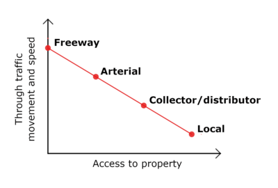
- Substandard construction affects the vertical axis – passing movement and traffic speed, sometimes called simply "mobility" – but the actual effect depends on the surroundings, for example, whether nearby streets are also substandard (relative to local standards) or in bad condition.
- Tags like lanes=* and width=* are objective and always welcome, but they fail to capture the idea that the structure of a given way is significantly below a local standard.
- There is no difference in importance between highway=unclassified and highway=residential, and every app I know of treats both exactly the same. In an urban street network, highway=unclassified was sometimes used as a kind of "quaternary" highway, but this usage was never widely adopted. I also don't see how highway=unclassified would help in the cases I mentioned, where only a few scattered residential segments have structural problems. Are you proposing that in Brazil we change the majority of residential ways to unclassified and use highway=residential for segments that present such issues?
- So far, this has been discussed from the drivers' perspective, but pedestrians and cyclists on these streets are also safer with less through traffic. In some countries, these streets would have been transformed into pedestrian or living streets or signposted motor_vehicle=destination, but not all countries work in the same way. In fact, in Brazil, highway=living_street has been used in the past for these cases (example, example), although there are no living streets in Brazilian traffic laws, with very few exceptions in municipal laws, mainly applied to wide streets in good condition in tourist areas. Other times, these types of ways have also been incorrectly mapped as highway=pedestrian, incorrectly tagged as access=private;destination or motor_vehicle=private;destination, or improperly deleted. This indicates that different mappers consider them to be something inherently different from the typical highway=residential, but are struggling to agree on a satisfactory representation. --Fernando Trebien (talk) 14:47, 5 October 2023 (UTC)
- I said "determine" , not affect. You can use the physical characteristics to aid in a decision, but using it as the main criteria doesn't clarify what's the functionality, besides narrower than highway=residential .
If only some would-be highway=residential have issues, then you should still keep the highway=residential . That's what they are. Use other attributes for the physical dimension.
The volume or speed of traffic isn't tagged anyway. It might also be argued narrower streets limits the volume and speed, making them safer. But this is not a transportation policy debate.
—— Kovposch (talk) 16:11, 5 October 2023 (UTC)
- I said "determine" , not affect. You can use the physical characteristics to aid in a decision, but using it as the main criteria doesn't clarify what's the functionality, besides narrower than highway=residential .
- Substandard construction can negatively affect functionality.
- This is still suspicious Tagging For renderer and router. Substandard, zoning, or planning doesn't determine functionality. There are lanes=* , lane_markings=* , passing_places=* , sidewalk=*, etc, and other qualitative or straightforward quantitative possibilities that can be used to distinguish them, besides width=* directly. Only the cover and the US examples are building backage alleys. service=alley shouldn't be used simply because it has "alley" in the name. They are not highway=service in the first place. Sure, organic growth, historic evolution, and non-enforced centrally planned etc will be complicated. But using service=alley doesn't show the difference with proper shared building backage facility access roads inside a public street block either.
- narrow=* should not be used either. It is for narrowing of a road, similar to those warning signs. It's not for any "narrow" road.
name=* is at most a part of a sufficient condition. It is a contributing factor, not decisive. There are unnamed highway=residential , and there can be named shared backage roads.
—— Kovposch (talk) 06:39, 5 October 2023 (UTC)

I think we should also consider the images currently used to show each way type in the wiki. For residential ways:


For alleys:


For me it is very clear that the narrow ways we are talking about, despite not fitting the conceptual/legal definition of alley used in some countries, are much closer to these last examples. --Fernando Trebien (talk) 15:33, 5 October 2023 (UTC)
- And you completely ignored the context of shared rear access for two of them. The 3rd one needs to further checked on what it is.
If you would an "alley" feature or attribute, you should invent another one, not abuse highway=service for the sake of service=alley only. You would need to explain why they should use highway=service as the feature.
There's already footway=alley . There can be some other solution for highway=residential .
—— Kovposch (talk) 16:17, 5 October 2023 (UTC)
For the purposes of this discussion and considering the strong words, I suspect Kovposch is not an experienced mapper, just a wiki writer. There is no Kovposch or kovposch user in OpenStreetMap. --Fernando Trebien (talk) 12:26, 6 October 2023 (UTC)
- Are you serious about accusing others of these? It's common to have different names, and this wiki doesn't allow you change names by administrators yet with the extension. I also have my country's law to be cautious about. I don't write wiki articles anyway.
What's this discrediting of opinions by holding an "experienced" criteria? I have only been active for 4 years. Purely numerically, I still created moreway, and modified morerelthan you. Let's not count changesets. That's even more meaningless. https://hdyc.neis-one.org/?Kovoschiz
Working in one of the highest density cities where skyscrapers, hilly terrain, and elevated structures (especially podiums and earthworks) occlude and distort imagery everywhere is not easy. Doesn't allow you to add and modify many objects quickly.
For the crux of this discussion, I have been asking you why highway=service should used. You have been ignoring the glaring fatal flaw of this solution. Anecdotally and circumstantially, even the central example photo of your use case have always been using highway=residential fine, without being changed to service=alley once.
Nowadays I only edit in my state. There's not many active contributors for the population and activity. I can still give you a view on East Asia:- Hong Kong: Mostly footway=alley in the urban areas. What I encounter in the suburbs and rural areas is roads that are highway=residential candidates being tagged as highway=service because they are "narrow", and called "service road" or "access road".
- Taiwan: Extra confusing when the addressing system use "alley" and "sub-alley" for all streets.
- Taiwan/Taiwan_tagging#無分級道路與其他特定用途道路 : The abuse of highway=service ignoring functionality is openly pointed out, opposed. service=alley is even emphasized as not indicating width in bold, asking users to use lanes=* and width=* etc.
- https://www.facebook.com/groups/OpenStreetMap.TW/permalink/2167008216697969/ : Post against such usage of service=alley
- Japan: Not much patterns, or discussions I can identify. Road classification has long been an issue, and perhaps worse in cities (viz the net of highway=secondary in Nishi-Shinjuku). Not helped by the community using free Slack with 90 days limitation. In 2016, there were doubts and solutions formulated against this usage of service=alley . https://www.mail-archive.com/talk-ja@openstreetmap.org/msg09187.html
- Macau: service=alley and highway=residential seem interlaced. Again anecdotally, File:マカオの路地裏 A Street by St. Pauls Cathedral (8383418479).jpg used on 路地 in Japanese is a highway=residential 710516678 710516678 . It can be seen "alley" is very subjective.
- Korea: Sorry, not much to say due to language differences. Seoul has rather limited numbers of service=alley though.
- I agree service=alley can be ambigious, unclear, and carries various connotation. Rear access is merely the signature use, but it should be respected. I totally support if eg a service=rear_access replaces it. If anything, "alley" should be an attribute usable on all features. Not only service=alley or footway=alley . Ie what about the sidewalk of an service=alley ? This includes the highway=pedestrian and highway=living_street currently sidestepping the issue too.
—— Kovposch (talk) 13:22, 6 October 2023 (UTC)- I'm glad you responded here, you didn't respond on your talk page but kept editing the wiki so I assumed you were ignoring me. I'll write a full reply later, but at least I see now that you agree that highway=service isn't always unambiguous. --Fernando Trebien (talk) 14:08, 6 October 2023 (UTC)
- Point by point:
If only some would-be highway=residential have issues, then you should still keep the highway=residential . That's what they are.
- This is where we differ in opinion. I don't think these are standard highway=residential. If you argue that simply providing access to residences is enough to be highway=residential, then many other types of ways would collapse into this type, like tertiary, secondary, etc. highway=residential isn't just about access to homes; it's a combination of access to homes and the ways's traffic function as a local road, distinct from collector or arterial function.
It might also be argued narrower streets limits the volume and speed, making them safer.
- Locals know it would be best to go around these streets. However, locals usually don't rely on maps when they're in familiar areas. Maps are mainly used by those who aren't familiar with the places they're going through.
- That is for non-motorised ways. We are talking about motorised ways.
- It appears that even in Taiwan, some local mappers are seeking a way to distinguish between these exceptionally narrow local streets and standard local streets.
It's [ambiguous] for service=alley . highway=service is quite clearly not appropriate
- service=alley is a type of highway=service.
you should invent another one
- Do you have any suggestions? --Fernando Trebien (talk) 20:39, 6 October 2023 (UTC)
The oldest documentation [7] is for "service road usually located between properties for access" to [8] "things such as back gardens, rear entrances, fire exits, and storage areas" with " in-between buildings" for the European case.
- The English article was created with minimal content in January 2010. As you said, the now questioned text was first added to the English article in August 2013, which added
very narrow streets which run in-between buildings, providing public through-access
. It has since been taken by translation into all other languages: to German in late 2014 (adding the first photo examples of these medieval narrow streets), to French (from German) and Japanese (from English) in 2015, to Czech in 2016, and to Spanish, Polish, Chinese and Farsi in early 2019. The Portuguese version was finally synchronized by me with the English version in early 2021. Most translators were (and some still are) active mappers in their respective areas. --Fernando Trebien (talk) 22:15, 6 October 2023 (UTC) - This post [9] you mentioned is from 15 February 2019, while the oldest Chinese translation on the wiki was done 4 days later. I think the author of the post was referring to the English version, but in any case, both versions contained this text, but the author does not mention it. And the first response to the post argues in favor of using service=alley for streets narrower than 5 meters. The following response then argues that
many(corrected) some local mappers follow Taiwan/Taiwan tagging, which at the time of the post contained the following (translated) text:[10] Other Roads [Proposed]
- Roads that are too narrow, allowing only a single vehicle to pass in each direction at a time, should be tagged as highway=service, service=alley. If it is a mountain road leading to a tourist attraction, tag it as highway=unclassified.
- Roads narrower than one lane, where cars are not allowed to enter but motorcycles and bicycles can pass, should be tagged as highway=service、service=alley、vehicle=no, and also motorcycle=yes、bicycle=yes.
- The Taiwanese guide was heavily edited 9 days later, replacing this text, and the final text was added 21 days later. This text was first written in the same guide in English in 2012 as:[11]
Other Roads [Proposed]
- Streets and alleys, which are too narrow for bidirectional traffic at the same time (i.e. only wide enough for one car at a time), should be tagged as highway=service, service=alley. If the road is a mountain road, which is the main access road to a given destination, tag it as highway=unclassified instead.
- And it was already present in the first version of the guide from March 2008, which contained:[12]
Narrow one lane roads within cities, often named Lanes or Alleys, are 'highway:service' roads.
- --Fernando Trebien (talk) 23:03, 6 October 2023 (UTC)
Japan: ... viz the net of highway=secondary in Nishi-Shinjuku
- Many popular digital maps in Japan make this strange classification there, perhaps following some official classification based on physical or administrative criteria, without considering the surroundings. Although official, it may not reflect the functionality well. If it's rare, it may be better to stick with an official source. Google Maps seems to suggest a more balanced hierarchy at this specific location. There, to achieve a clearer hierarchy, it may be better to demote some wide streets that are slower, used primarily for parking or access to the buildings, too short to move a lot of traffic through or around that high-density area, or unable to do so due to restrictions in signage. What I propose for service=alley may seem to contract this, but it addresses a different extreme.
In 2016, there were doubts and solutions formulated against this usage of service=alley . [13]
- This mapper expressed some uncertainty and also stated that their decision was based on a personal observation of various opinions at that particular time. But certainly every opinion counts.
Macau: ... File:マカオの路地裏 A Street by St. Pauls Cathedral (8383418479).jpg used on
路地 in Japanese is a highway=residential- To me it also looks like highway=residential, as it seems quite wide. In this video [14] in Pátio da Claridade, when the camera turns against the motorbikes at 0:27, that way, if possible and allowed for cars, could perhaps be a public service=alley there. It seems difficult for two cars to pass each other in that space. --Fernando Trebien (talk) 04:54, 7 October 2023 (UTC)
- You mistranslated. The other reply in Taiwan was merely providing "potentially useful" reference to the guideline, explained to be something followed by "some" users. The explanation is for what a guideline in OSM is (in the sense of "laws" vs rules vs conventions). It doesn't equates to most or many people following and agreeing with that definition of service=alley . Is every user even aware of this attribute? The first reply is a comment based on end user behavior for rendering and routing caused by service=alley . It doesn't consider whether service=alley is the most appropriate solution. There was no reply after further dissenting opinion. If a guideline has been opposed, is correcting it to be consistent with the definition of highway=service itself (which is not for external roads) completely wrong? Note it is marked as "proposed" for some reason. To compare, the "narrow road" in Tag:highway=service#Examples is described for "between properties" in the meaning of shared rear access. It has not been updated to reflect the added usage of service=alley in Tag:service=alley either.
You misinterpreted my sentences and replied to them randomly. footway=alley is referring to the situation where some ways are getting an alley attribute, while others viz highway=pedestrian and highway=living_street can't be shown to be an "alley", besides the pedestrianization and pedestrian priority. service=alley is thus an incomplete solution.
highway=tertiary and above has higher movement function on top of highway=residential . On the contrary, it can equally be claimed the proper internal highway=service has a lower movement function than what's using service=alley externally, therefore highway=service should not be used, and service=alley is a mismatch.
All you seemed to have repeated is highway=service should be used because of "alley" existing in service=alley . Any more justification on using highway=service in the first place?
—— Kovposch (talk) 10:44, 7 October 2023 (UTC)It doesn't equates to most or many people following and agreeing with that definition of service=alley .
- Correct, my mistake. The user said "some" (一部分, literally "one part"), not "many" people.
If a guideline has been opposed, is correcting it to be consistent with the definition of highway=service itself (which is not for external roads) completely wrong?
- If it does not correspond to the mapping practice, the change may be motivated simply by dogma or purism. In OSM there are highway=residential + access=private, particularly in large gated communities. So, if the residential type is reused for private ways simply because they look like public residential streets, the question of whether there are public service=alley somewhere in the world is perfectly valid. The text
Service roads are not parts of the public road network
was only added to highway=service on 7 August 2023, two months ago. The new text appears to be undiscussed and may conflict with established practices as defined in OSM tags for routing/Access restrictions. Any more justification on using highway=service in the first place?
- The main point is that, in terms of mobility, these substandard ways function more like back alleys than regular local ways. Due to the low mobility, locals avoid them, and map users expect not only that routers also avoid them, but also that they are informed about the lower mobility when they look at the rendered map.
- All local communities seek a correspondence between their local reality and OSM's highway types, this may make sense for some countries and not for others. There are obviously no “medieval” streets in North America, so this debate makes little sense there. In the US, most (back) alleys without signage are public and can be legally used as shortcuts (although they are not designed for that), but in many places there it is prohibited to stop or park in (back) alleys. So, except for the aspect of rear access to properties, these ways have the same characteristics as public narrow streets in Brazil (here nobody is allowed to block a public street). It may be that (back) alleys are not public by default in other countries, but from what I'm researching, they seem to be public in the UK and many other countries as well, unless signposted. Narrow medieval streets emerged in Europe at a time when modern urban planning did not exist. The narrow roads I mentioned earlier in Brazil emerged from uncontrolled urban growth. Although the surrounding properties are very different, there are similarities both in how they emerged and in the consequences for mobility. --Fernando Trebien (talk) 14:25, 7 October 2023 (UTC)
- (Having been involved via Talk:Tag:highway=service): Part of the problem is that OSM scheme does not have a well-defined tag for "residential" public or semi-public highways of lower level than a highway=residential, thus highway=service comes as a natural choice to mappers. Since that's a low-level importance road anyway, routers are not keen to use it for navigation, and renderers display it with thin enough lines.
Like Fernando Trebien, I plead guilty to using service=alley in my country (Serbia) for lowest-level arteries branching to small neighborhoods (2-10 houses) off a "main" highway=residential in rural/suburban settings. Those are typically cul-de-sacs, or continuing in a highway=track. My main criterion is that those are officially unnamed (addresses belong to the main street). I don't like to have too many branches of a named residential and I'd prefer to distinguish those cul-de-sacs from the main street. Other mappers tend to use bare highway=service or (IMO incorrectly) highway=unclassified to such highways.
Personally, I would prefer to devolve tagging decisions of such low-importance highways to country-level projects, rather than trying to impose one-size-fits-all worldwide solution, since 1) there is lot of cultural factors involved and 2) the stakes of "mis-tagging" are low (a bare highway=service is by default access=yes unless you specify otherwise). Duja (talk) 13:33, 10 October 2023 (UTC)
- (Having been involved via Talk:Tag:highway=service): Part of the problem is that OSM scheme does not have a well-defined tag for "residential" public or semi-public highways of lower level than a highway=residential, thus highway=service comes as a natural choice to mappers. Since that's a low-level importance road anyway, routers are not keen to use it for navigation, and renderers display it with thin enough lines.
- You mistranslated. The other reply in Taiwan was merely providing "potentially useful" reference to the guideline, explained to be something followed by "some" users. The explanation is for what a guideline in OSM is (in the sense of "laws" vs rules vs conventions). It doesn't equates to most or many people following and agreeing with that definition of service=alley . Is every user even aware of this attribute? The first reply is a comment based on end user behavior for rendering and routing caused by service=alley . It doesn't consider whether service=alley is the most appropriate solution. There was no reply after further dissenting opinion. If a guideline has been opposed, is correcting it to be consistent with the definition of highway=service itself (which is not for external roads) completely wrong? Note it is marked as "proposed" for some reason. To compare, the "narrow road" in Tag:highway=service#Examples is described for "between properties" in the meaning of shared rear access. It has not been updated to reflect the added usage of service=alley in Tag:service=alley either.
.jpg)
Alternatives
An issue with providing an attribute for "alley" is inconsistency with other road types in this language. "avenue" or "boulevard" don't have one. The most unique piece for the former is tree_lined*=* for one aspect of the meaning, which is still not very common. There is benefit in them. Walking or riding on them can be comfortable for traffic, and pleasant for the environment. They are supposed to have higher standards than other roads. Yet there doesn't seem to be a pressing need to indicate them.
The usefulness of having a unique alley=yes (N=31) seems limited. (In fact, the meaning of 666 alley=* for sides need to be checked.) Similarly, I'm not a fan of a dedicated expressway=* except when signposted due to overly broad and different conflicting meanings, when the dual_carriageway=* & carriageway=* and access_control=* that exist are more specific and physical. alley=* may cause other misunderstandings, again in Taiwan as mentioned.
I have already raised eg service=rear_access to possibly replace service=alley in part. So alley=* doesn't have other potential uses yet.
I hope a generic classification won't be as bad as practicability=* etc. Eg narrow_road=alley may be confusing for how subjective narrow_road=* can be. There is 1 narrow_lanes=* 229625843![]() 229625843 with lanes=2 , which means it may be useful for narrower lanes at signalized junctions as narrow_road=lanes to show only the lanes are narrow (in the sense of DMRB CD 123 7.8.1 "At existing junctions, straight ahead lanes should only be reduced to 2.5m or less, if this allows the total number of lanes to be increased" https://www.standardsforhighways.co.uk/tses/attachments/962a81c1-abda-4424-96c9-fe4c2287308c?inline=true#page=55 ) , or in general for roads marked with 2 car-width lanes not allowing 2 trucks to pass. narrow_road=obstacle may be used to show the obstacle=* has caused the road to effectively narrow significantly. (obstacle=* alone may only block 1 lane, or a small width of it) At least this could remove incorrect usage of narrow=* that are not narrowing sections of a wider road.
229625843 with lanes=2 , which means it may be useful for narrower lanes at signalized junctions as narrow_road=lanes to show only the lanes are narrow (in the sense of DMRB CD 123 7.8.1 "At existing junctions, straight ahead lanes should only be reduced to 2.5m or less, if this allows the total number of lanes to be increased" https://www.standardsforhighways.co.uk/tses/attachments/962a81c1-abda-4424-96c9-fe4c2287308c?inline=true#page=55 ) , or in general for roads marked with 2 car-width lanes not allowing 2 trucks to pass. narrow_road=obstacle may be used to show the obstacle=* has caused the road to effectively narrow significantly. (obstacle=* alone may only block 1 lane, or a small width of it) At least this could remove incorrect usage of narrow=* that are not narrowing sections of a wider road.
—— Kovposch (talk) 10:56, 7 October 2023 (UTC)
Duplicate discussion
There is another community forum discussion on this topic. --Fernando Trebien (talk) 23:19, 21 February 2024 (UTC)
Current mapping practices
A recent debate has raised some questions about the definition and use of this tag and how it can be adapted to new contexts, particularly about whether it should be used for narrow, possibly medieval, public ways that provide access to the front of properties. Map data suggests that restricting the tag to only ways that provide access to the rear of properties is a practice limited to English-speaking countries, possibly related to the urban planning culture of those countries (eg. ![]() Radburn design housing).
Radburn design housing).
I found the following examples by taking a random sample of 30 ways mapped as service=alley in each place after selecting them using an Overpass query, then I chose the ones that seemed public. The resulting proportion may provide a rough estimate of how often service=alley is used for public ways in these locations. Some may be mapped incorrectly. From this, data it appears that service=alley:
- is relatively often public, and in some places it is usually public
- is sometimes a dead end, and in some places it is usually a dead end
- often provides access to the rear of properties in the two English-speaking countries inspected (UK and US)
- often provides access to the front of properties in other non-English speaking countries (Germany, France, Italy and Spain), but are also notably different from most other nearby residential ways, resulting in a more local function than those residential ways, for various situations such as:
- being narrow for vehicle circulation (only one vehicle can pass through narrow points at a time); or
- lacking sidewalks unlike most other local streets nearby; or
- providing local access to public parking
In addition to the country capitals, I also looked at Edinburgh, Nuremberg and Strasbourg because I knew they had some narrow medieval ways, but in these three cities, almost none of the ways tagged as service=alley fit in this case. The place where they were widely used for this case was in Rome.
| # | Way | Front access to properties | Medieval | Narrow for vehicles | Sidewalk | Exit |
|---|---|---|---|---|---|---|
| 1 | unnamed | no | no | yes | no | no |
| 2 | unnamed | no | no | yes | no | no |
| 3 | unnamed | no | no | yes | no | no |
| 4 | unnamed | no | no | yes | no | no |
| 5 | unnamed | no | no | yes | no | no |
| 6 | unnamed | no | no | yes | no | no |
| 7 | unnamed | no | no | yes | no | no |
| 8 | unnamed | no | no | yes | no | no |
| 9 | unnamed | no | no | yes | no | no |
| 10 | unnamed | no | no | yes | no | yes |
| 11 | unnamed | no | no | yes | no | yes |
| 12 | unnamed | no | no | yes | no | yes |
| 13 | unnamed | no | no | yes | no | yes |
| 14 | unnamed | no | no | yes | no | yes |
| 15 | unnamed | no | no | yes | no | yes |
| 16 | unnamed | no | no | yes | no | yes |
| 17 | unnamed | no | no | yes | no | yes |
| 18 | unnamed | no | no | yes | no | yes |
| 19 | unnamed | no | no | no | yes | no |
| 20 | Abbots Terrace | yes | no | yes | no | no |
| # | Way | Front access to properties | Medieval | Narrow for vehicles | Sidewalk | Exit |
|---|---|---|---|---|---|---|
| 1 | Suffolk Road Lane | no | no | yes | no | yes |
| 2 | Pansy Walk | no | no | yes | no | yes |
| 3 | unnamed | no | no | yes | no | yes |
| 4 | unnamed | no | no | yes | no | yes |
| 5 | Robertson's Close | yes | no | yes | no | no |
| 6 | unnamed | yes | no | yes | no | no |
| 7 | Annandale Street Lane | yes | no | yes | no | yes |
| 8 | Gentle's Entry | yes | no | no | curbless | yes |
| 9 | Stable Lane | no | no | yes | no | no |
| 10 | unnamed | no | no | no | no | no |
| # | Way | Front access to properties | Medieval | Narrow for vehicles | Sidewalk | Exit |
|---|---|---|---|---|---|---|
| 1 | unnamed | no | no | no | no | yes |
| 2 | unnamed | no | no | no | no | yes |
| 3 | unnamed | no | no | no | no | yes |
| 4 | unnamed | no | no | no | no | yes |
| 5 | unnamed | no | no | no | no | yes |
| 6 | unnamed | no | no | no | no | yes |
| 7 | unnamed | no | no | no | no | yes |
| 8 | unnamed | no | no | no | no | yes |
| 9 | unnamed | no | no | no | no | yes |
| 10 | unnamed | no | no | no | no | yes |
| 11 | unnamed | no | no | yes | no | yes |
| 12 | unnamed | no | no | yes | no | yes |
| 13 | unnamed | no | no | yes | no | yes |
| 14 | unnamed | no | no | yes | no | yes |
| 15 | unnamed | no | no | yes | no | yes |
| 16 | unnamed | no | no | yes | no | yes |
| 17 | unnamed | no | no | yes | no | yes |
| 18 | Mechanics Alley | no | no | yes | no | yes |
| 19 | Challenge Playground | no | no | yes | no | yes |
| 20 | Cortlandt Alley | yes | no | no | yes | yes |
| 21 | Cortlandt Alley | yes | no | yes | yes | yes |
| # | Way | Front access to properties | Medieval | Narrow for vehicles | Sidewalk | Exit |
|---|---|---|---|---|---|---|
| 1 | Flotowstraße | yes | no | yes | no | yes |
| 2 | Gottfried-Keller-Straße | yes | no | yes | no | yes |
| 3 | Mittelweg | yes | no | yes | no | yes |
| 4 | Teltower Damm | yes | no | yes | no | no |
| 5 | unnamed | yes | no | yes | no | no |
| 6 | Kirchgasse | yes | yes | yes | yes | yes |
| 7 | Am Mühlenberg | yes | yes | yes | yes | yes |
| 8 | Ruthnerweg | yes | no | yes | yes | no |
| 9 | Schwarzdornweg | yes | no | no | no | yes |
| 10 | Leester Weg | yes | no | no | yes | no |
| # | Way | Front access to properties | Medieval | Narrow for vehicles | Sidewalk | Exit |
|---|---|---|---|---|---|---|
| 1 | Chemin du Bel-Air | yes | no | no | yes | no |
| 2 | Impasse de l'Orangerie | yes | no | no | yes | no |
| 3 | unnamed | yes | no | no | yes | no |
| 4 | Rue de la Fontaine Bridel | yes | no | yes | no | no |
| 5 | Sente des Toits Rouges | yes | no | yes | no | no |
| 6 | Place Berlioz | yes | no | no | yes | yes |
| 7 | Allée des Épinettes | yes | no | no | yes | yes |
| 8 | Rue André Citroën | yes | no | no | no | yes |
| 9 | Rue Briffault | yes | no | no | no | yes |
| 10 | Passage des Taillandiers | yes | no | yes | yes | yes |
| 11 | Rue de la Sourdière | yes | no | yes | yes | no |
| 12 | Passage Saint-Pierre Amelot | yes | no | yes | partial | yes |
| 13 | Impasse d'Antin | yes | no | yes | partial | no |
| 14 | Sentier des Boves | yes | no | no | no | no |
| 15 | Route de Suresnes | no | no | no | yes | yes |
| # | Way | Front access to properties | Medieval | Narrow for vehicles | Sidewalk | Exit |
|---|---|---|---|---|---|---|
| 1 | Impasse de la Lune | yes | no | yes | no | no |
| 2 | Rue Saint-Fridolin | yes | no | yes | no | no |
| 3 | Rue de l'Ill | yes | no | yes | no | no |
| 4 | Rue Virgile | yes | no | yes | no | no |
| 5 | Rue Kempf | yes | no | yes | no | no |
| 6 | Rue Rettig | yes | no | yes | no | no |
| 7 | Chemin du Rohrwoerth | yes | no | yes | no | no |
| 8 | unnamed | yes | no | yes | no | no |
| 9 | Rue de la Couronne | yes | no | yes | no | yes |
| 10 | Rue du Jardin | yes | no | yes | no | yes |
| 11 | Rue Jean-Georges Pick | yes | no | yes | no | yes |
| 12 | Rue du Cercle | yes | no | yes | no | yes |
| 13 | Rue des Jardins | yes | no | yes | no | yes |
| 14 | Rue Saint-Bruno | yes | no | yes | no | yes |
| 15 | Rue Jacob Mayer | yes | no | yes | no | yes |
| 16 | Rue Jean-Philippe Schoenfeld | yes | no | yes | yes | no |
| 17 | Rue Lyautey | yes | no | no | yes | yes |
| 18 | Rue Émile Baas | yes | no | no | no | yes |
| 19 | Rue Marc Aurèle | no | no | yes | yes | yes |
| 20 | Rue des Perdrix | no | no | no | no | yes |
| 21 | Rue du Tonnelet Rouge | yes | yes | yes | no | yes |
| # | Way | Front access to properties | Medieval | Narrow for vehicles | Sidewalk | Exit |
|---|---|---|---|---|---|---|
| 1 | Via dei Falegnami | yes | yes | yes | no | yes |
| 2 | Vicolo della Campana | yes | yes | yes | no | yes |
| 3 | Via dei Chiavari | yes | yes | yes | no | yes |
| 4 | Via della Fossa | yes | yes | yes | no | yes |
| 5 | Via dei Maroniti | yes | yes | yes | no | yes |
| 6 | Via della Pelliccia | yes | yes | yes | no | yes |
| 7 | Vicolo delle Palle | yes | yes | yes | no | yes |
| 8 | Via del Seminario | yes | yes | yes | no | yes |
| 9 | Vicolo delle Palline | yes | yes | yes | no | yes |
| 10 | Via Azone | yes | no | yes | no | yes |
| 11 | Via degli Arbusti | yes | no | yes | no | yes |
| 12 | Vicolo della Fontana | yes | no | yes | no | yes |
| 13 | Via dell'Arco de' Ginnasi | yes | yes | no | no | yes |
| 14 | Via di Montecatini | yes | yes | no | no | yes |
| 15 | Via Gregorio XIII | yes | no | yes | no | no |
| 16 | Clivo di Sant'Antonino | yes | no | yes | no | no |
| 17 | Via Seravezza | yes | no | no | no | yes |
| # | Way | Front access to properties | Medieval | Narrow for vehicles | Sidewalk | Exit |
|---|---|---|---|---|---|---|
| 1 | Calle de La del Manojo de Rosas | yes | no | no | yes | no |
| 2 | Calle del Golfo de Salónica | yes | no | no | yes | no |
| 3 | Calle Barón de la Torre | yes | no | no | yes | no |
| 4 | Calle de Abdón Terradas | yes | no | no | yes | no |
| 5 | Calle de Santa Adela | yes | no | no | yes | no |
| 6 | Calle de la Sagra | yes | no | no | yes | no |
| 7 | unnamed | yes | no | no | yes | no |
| 8 | Calle de la Bureba | yes | no | yes | yes | no |
| 9 | Calle de La Rioja | yes | no | yes | yes | no |
| 10 | Calle de Uruguay | yes | no | yes | yes | no |
| 11 | Calle Luis Mitjans | yes | no | yes | yes | no |
| 12 | Calle de la Alcarria | yes | no | yes | yes | no |
| 13 | Pasaje de Paquitín | yes | no | no | no | no |
| 14 | Calle San Telmo | yes | no | no | no | no |
| 15 | unnamed | no | no | no | yes | no |
| 16 | unnamed | no | no | no | yes | no |
| 17 | Calle de La del Soto del Parral | yes | no | yes | curbless | no |
| 18 | Travesía del Oxígeno | no | no | yes | no | no |
| 19 | unnamed | yes | no | yes | yes | yes |
In Paris, Strasbourg and Berlin, a small number of these ways are signposted as living streets and may be tagged incorrectly in OSM (or perhaps they should also have living_street=yes). In France and Italy, some not-so-narrow streets were tagged as service=alley, apparently because only one car could pass at a time. Sometimes these ways have wide sidewalks, sometimes the area for vehicles is wide but there is only one lane to drive and the rest of the space is filled by parked vehicles. In Rome, narrow service=alley ways sometimes widen into squares and then narrow again. In these cases, the classification is kept low at service=alley, producing alley networks without pockets of (typically) wider highway=residential, ensuring map legibility in complex areas.
In London and New York, service=alley is used in many ways that provide rear access to properties. For many of these ways, it wouldn't make much sense to debate whether they are public or not, because they are dead ends and generally only useful for accessing back entrances. Most of those that can be used to go through from one end to the other, for example by pedestrians and cyclists, and occasionally by drivers, are, in principle, public even for drivers, as they are neither signposted nor blocked, but undesirable due to low practical speed, which is intentional.
I took a quick look at Tokyo and Taipei (mentioned in another discussion) and the usage pattern there resembles that in the non-English-speaking countries, with the vast majority being public ways with a local traffic function, providing access to the front of properties, being relatively narrow for cars (only 1 lane of traffic, excluding parking lanes).
In 2021, I had observed these variations in the data before changing the Portuguese version of the article. --Fernando Trebien (talk) 17:00, 13 October 2023 (UTC)
Since there have been some claims that the practice of using service=alley is different in Asia, which is not what I have observed so far, I started collecting examples in major Asian cities using the same random sampling method. In Tokyo, most of the ways mapped out as service=alley there are modern public narrow motorised streets that provide the main access to residences. The most common tagging mistake I found is that some of these streets are signposted pedestrian-only.
| # | Way | Front access to properties | Medieval | Narrow for vehicles | Sidewalk | Exit |
|---|---|---|---|---|---|---|
| 1 | unnamed | yes | no | yes | no | yes |
| 2 | unnamed | yes | no | yes | no | yes |
| 3 | unnamed | yes | no | yes | no | yes |
| 4 | unnamed | yes | no | yes | no | yes |
| 5 | unnamed | yes | no | yes | no | yes |
| 6 | unnamed | yes | no | yes | no | yes |
| 7 | unnamed | yes | no | yes | no | yes |
| 8 | unnamed | yes | no | yes | no | yes |
| 9 | unnamed | yes | no | yes | no | yes |
| 10 | unnamed | yes | no | yes | no | yes |
| 11 | unnamed | yes | no | yes | no | yes |
| 12 | unnamed | yes | no | yes | no | yes |
| 13 | unnamed | yes | no | yes | no | yes |
| 14 | unnamed | yes | no | yes | no | yes |
| 15 | unnamed | yes | no | yes | no | yes |
| 16 | unnamed | yes | no | yes | no | yes |
| 17 | unnamed | yes | no | yes | no | yes |
| 18 | unnamed | yes | no | yes | no | yes |
| 19 | unnamed | yes | no | yes | no | yes |
| 20 | unnamed | yes | no | yes | no | yes |
| 21 | unnamed | yes | no | no | no | yes |
| 22 | unnamed | yes | no | no | no | yes |
| 23 | unnamed | yes | no | yes | no | no |
| 24 | unnamed | yes | no | no | no | no |
--Fernando Trebien (talk) 20:54, 24 February 2024 (UTC)
- Taipei: You need to understand it's heavily influenced by the addressing system. For 6.6k highway=residential , there are 1120 containing "弄", and thus 3829-1120=2709 "巷"-only. This is not a great difference from the 6.9k service=alley with 1541 "弄" , and 4383-1541=2842 "巷"-only.
Tokyo: For reference, you will only be able to find Tokyo Metropolis geocoded in OSM, which contains the western Tama area, and the small islands far out. The top 5 users @yoshitk , @1-0-6-6 , @KKK-jp , @higa4 , @ryo-a with more than 1k as last editing users account for 10.5k of the 17.5k service=alley . @Kentni has 620. This is more dominate in the 23 Wards Area, where @yoshitk , @1-0-6-6 have >1k last edited. Together with @higa4 , @ryo-a , and @Kentni , they are 4.9k of the 7.3k service=alley in a z=13 bbox centered in the city. Many of them have a last update date several years ago. This needs to factor in First Mapper influence. From casual inspection, some were created as highway=residential , highway=unclassified , and highway=living_street . Besides 路地, highway=living_street is another translation problem for 生活道路. The Yahoo import also needs to be understood. As I have mentioned several times, Japan has an obvious road classification problem, which has been noticed on Discord as well.
—— Kovposch (talk) 11:02, 27 February 2024 (UTC)- I think this means that in Taipei, a way having "alley" in its name does not have a close correlation with being mapped as an alley (that's ok), and that in Tokyo, the main contributors, still active, are most responsible for putting service=alley in the map. But I wonder what the implications of these facts are for this discussion.
- I think the first mappers probably did like me: they read the English wiki, checked the map of the UK, checked the map of some other countries with active mappers (like many European countries) and it seemed to them that there was no major problem with mapping alleys like they are doing now.
- I know the types of problems that can arise when imperfectly matching one classification system to another on import. Whenever detected, a manual cleanup activity can be organized. So the question is whether there is any public discussion about the Yahoo import issues, but I didn't find anything on Category:Import from Japan. Incorrectly classified ways can be created by imports and by typical mapping, so I expect to see some streets created as alleys being reclassified as residentials and vice versa. --Fernando Trebien (talk) 13:47, 27 February 2024 (UTC)
Subtagging meaning
I would like to remind that the added service=* means it's a less important highway=service than one without, as involved in Tag:service=driveway2 before. Internal rear access roads might be found inside some sites served by highway=service , but the narrow "public" road meaning is always more important than a plain highway=service . It's another self-contradiction.
I'm in favor of Proposal:Service=parking etc. But this is another thing to be aware of.
—— Kovposch (talk) 11:16, 1 March 2024 (UTC)
- For clarity, according to the article on highway=service, the absence of service=* on the map just means there is a lack of detail. One can only compare the relative importance of two ways with service=* and two ways without service=*, not one with and one without. --Fernando Trebien (talk) 17:42, 23 April 2024 (UTC)
- Umm, do you have any idea what you are talking about? Even renderers treat them differently. This shows the documentation has been worded wrongly. Please read previous discussions.
- —— Kovposch (talk) 04:23, 24 April 2024 (UTC)
- I don't have any idea what you are talking about, and I don't see anything in your linked discussions that affirms your assertion that "added service= means it's a less important highway=service than one without". We all agree that driveway2 was one mapper's confused idea that was rightfully removed and deprecated, so I don't see what that proves. As Fernando said, absence of more specific tag traditionally means that the information is lacking, not that it has a specific meaning. Duja (talk) 08:09, 24 April 2024 (UTC)
- That's not how highway=service is treated now. How are you using it then? Please read again. "Paths in or around a parking lot (amenity=parking) are tagged with highway=service without service=* on the entrance and exit ways, as well as any way that forms the "trunk" or perimeter of the lot, connecting multiple parking aisles (service=parking_aisle).", "This RFC highlighted significant support for bare highway=service without any service=*" . All 3 agreed that highway=service without service=* should be used for these higher level roads. —— Kovposch (talk) 09:00, 24 April 2024 (UTC)
- highway=service is used for a wide variety of highways. Basically, it's a catch-all tag for all sorts of car-accessible auxiliary roads outside of main road classification. Therefore, it does not make sense to talk about "importance" of service roads in general. They are all generally of lesser "importance" than highway=residential or highway=unclassified and on the similar level as highway=track.
For the special case of service=parking_aisle, I can agree that there exists a "higher-importance" service road that used to be tagged as "driveway2" which someone proposed to rename to service=parking_access (if I remember well), but the voting settled on bare highway=service. That has been duly noted on Tag:service=parking_aisle#Disambiguation, but the principle that "unspecified service= is of higher importance than the specified ones" is not universal for all service roads. Duja (talk) 12:11, 24 April 2024 (UTC)- In what other service=* do you find it not universal for highway=service without service=* to be more important? Besides the topic of service=alley here. —— Kovposch (talk) 16:08, 24 April 2024 (UTC)
- It's impossible to know whether the absence of a tag, and especially a subtag, means that mappers checked something and intentionally left it out, or if the data is simply missing because no one checked it, which is why this type of rule is problematic for data consumers and for map quality assurance. --Fernando Trebien (talk) 17:02, 24 April 2024 (UTC)
- In what other service=* do you find it not universal for highway=service without service=* to be more important? Besides the topic of service=alley here. —— Kovposch (talk) 16:08, 24 April 2024 (UTC)
"Paths in or around a parking lot (amenity=parking) are tagged with highway=service without service=* on the entrance and exit ways, as well as any way that forms the "trunk" or perimeter of the lot, connecting multiple parking aisles (service=parking_aisle)."
- This was written in 2019, before the discussion on the tagging mailing list in 2020, where only the first two replies supported the idea of banning service=* for this case, the other answers preferred to continue to use subtagging for detailing, as usual. It also preceded the 2023 forum thread where I found nobody supporting banning service=* for this case. Therefore, I think this piece of text in service=driveway is misleading as it does not reflect current consensus.
"This RFC highlighted significant support for bare highway=service without any service=*"
- The RFC status has been "under way" since 2020 and there are no votes yet, so it has likely been abandoned. --Fernando Trebien (talk) 12:36, 24 April 2024 (UTC)
- The situation is there is no consensus on what service=* should be used for that either. Not using service=* is the norm. The other implication is such interpretation of service=alley may create a 3rd level that's more important than the absence of service=* , and this potential service=* to replace it.
- It has nothing to do about the RfC itself, only what comments it received...
- —— Kovposch (talk) 16:08, 24 April 2024 (UTC)
- In terms of mobility, service=alley is about as important as a non-specific highway=service way without service=* (most of which are actually service=driveway): generally a driver wants to avoid a network of service ways (service=alley, service=driveway, service=drive-through, etc.) when going through an area, but they will have to enter it when the destination is within that network. In other words, for motor vehicles, it is generally desirable to avoid shortcuts through narrow streets when there are wider, better-flowing streets nearby. For cyclists and pedestrians, the situation is opposite: narrow streets are generally avoided by fast-moving traffic, so they are safer and therefore more desirable. --Fernando Trebien (talk) 17:44, 24 April 2024 (UTC)
- highway=service is used for a wide variety of highways. Basically, it's a catch-all tag for all sorts of car-accessible auxiliary roads outside of main road classification. Therefore, it does not make sense to talk about "importance" of service roads in general. They are all generally of lesser "importance" than highway=residential or highway=unclassified and on the similar level as highway=track.
- That's not how highway=service is treated now. How are you using it then? Please read again. "Paths in or around a parking lot (amenity=parking) are tagged with highway=service without service=* on the entrance and exit ways, as well as any way that forms the "trunk" or perimeter of the lot, connecting multiple parking aisles (service=parking_aisle).", "This RFC highlighted significant support for bare highway=service without any service=*" . All 3 agreed that highway=service without service=* should be used for these higher level roads. —— Kovposch (talk) 09:00, 24 April 2024 (UTC)
- I don't have any idea what you are talking about, and I don't see anything in your linked discussions that affirms your assertion that "added service= means it's a less important highway=service than one without". We all agree that driveway2 was one mapper's confused idea that was rightfully removed and deprecated, so I don't see what that proves. As Fernando said, absence of more specific tag traditionally means that the information is lacking, not that it has a specific meaning. Duja (talk) 08:09, 24 April 2024 (UTC)