Proposal:Utility markers proposal
| The Feature Page for the approved proposal Utility markers is located at Key:marker |
| The Feature Page for the approved proposal Utility markers is located at Key:utility |
| Utility markers | |
|---|---|
| Proposal status: | Approved (active) |
| Proposed by: | Fanfouer |
| Tagging: | marker=* & utility=* |
| Applies to: | |
| Definition: | Improve utility markers mapping by consolidate usage of marker key |
| Draft started: | 2019-05-09 |
| RFC start: | 2019-07-14 |
| Vote start: | 2019-10-12 |
| Vote end: | 2019-10-26 |
Utility markers can be seen pretty everywhere in cities and in countries also. OSM use to map them with several keys, depending on which kind of utility or purpose they was intended for. This proposal will try to summarize many sort of them and propose a unique set of values for the marker=* key.
Rationale
Utilities feature all networks that provides useful energy or fluids to human activities (industry, domestic appliances, public works...).
These networks can be really dense and often buried undeground in cities as to reduce their vulnerablity, visual impact and improve people security.
Markers are used to remind us about their underground presence. Any forgotten gas or high voltage line can have desastreous impact on any occasional digger reaching them.
Furthermore, markers are great visual helps for navigation or location on unknown places. Refs and colour can help anyone who want to locate on a map.
Currently, OSM only knows certain markers, for pipeline and underground power cables but there are many more situations where markers are used. A side issue is markers aren't properly part of the line they refer to. Then it may be confusing to use power=* or pipeline=* as it leads to think the marker is directly installed on the pipeline or cable.
It seems interesting to group the general knowledge of markers under a single key instead of defining the same concepts on each mapping subject.
Finally, marker shapes are designed for a given purpose, depending to whom is supposed to read them. Underground pipelines may be inspected by plane or helicopter and some markers come with kind of roof cover displaying signs. Documenting shapes may improve rendering and knowledge of their shape as to distinguish them on ground as landscape elements.
Proposal
It is proposed to use marker=* key to map markers according to their shape and utility=* to state at which activity they refer to, without preventing to extend it to any other feature in the future (by defining different new values). Usage of support=* is not required anymore since design information includes used support.
This proposal focuses on man made infrastructure buried underground: pipelines, power cables and supplies, telecommunication lines (both copper and fibre) and fire hydrants.
Markers will be described with existing and meaningful keys material=* and location=* keys which won't be modified by this proposal.
As a consequence markers aren't properly involved of the process of the infrastructure they refer to, it is also proposed to make marker=* incompatible with voltage=*, frequency=*, pressure=*, diameter=* since it's not appropriate properties.
There are exitsing keys like pipeline=marker that should not be used anymore as to not clutter naming intended for directly-connected-to-pipelines and operational involved features (valves, pumps, tanks...).
How to map
Once located on ground during a survey or got from public information / street level pictures, just put a node on the exact point and add following tagging on it.
For sake of One_feature,_one_OSM_element, each marker should get its own node on OSM at the exact place it belongs to.
Markers will surely indicate that a particular linear feature (pipeline, power cable...) lies next to it. Nevertheless, markers are installed to be seen and prevent damage at various distances from the feature they refer to. So it's not recommended to put markers directly on pipeline or cable ways, unless the marker is seen fixed on them. Markers are not devices with direct impact or sensing on live features so share nodes between lines and them wouldn't be accurate.
Tagging
Here is a summary of recommended tagging for a utility marker
| Key | Value | Comment | Recommendation |
|---|---|---|---|
| marker | <marker shape> | The node corresponds to a marker seen on ground | mandatory |
| utility | <utility> | Activity the marker is referring to | recommended |
| material | <material> | The material composing most of the marker (referring to the support if dedicated) | optional |
| location | <location> | The physical location of the marker, often overground | optional |
| ref | <marker ref> | If available, the ref as it can be read on the marker | optional |
| operator | <company name> | The name of company who operate the marker (and often the associated linear feature, cable or pipeline) | optional |
| colour | <colour> | The most representative colour of the marker | optional |
pressure=* and voltage=* are explicitly not mentioned here as it's not a property of the marker itself but of the buried infrastructure it refers to. You'd better to add them to corresponding feature and not on the marker with these keys. You can still add a note=* or use description=* as to not loose information.
And a list of possible values for marker=* depending of their design.
This list can be completed as needed with equivalent values valuable in other fields of knowledge if needed.
| Key | Value | Comment |
|---|---|---|
| marker | post | Standard kind of marker composed of a pole/mast with useful information written on it. The support have to be dedicated to marker, see plate for other situations |
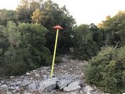
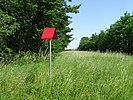
| aerial | A marker that is intended and designed accordingly to be seen from aircraft dedicated to networks inspection. | |
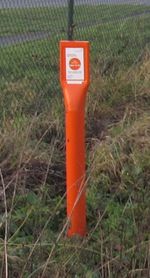
| pedestal | Unlike a stone, pedestal are man made and can be whether in plastic or in concrete. Useful information is found on top of them. | |
| stone | A stone is a natural support where useful information is directly etched or painted on it. | |
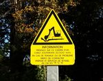
| plate | A kind of sign installed on walls without any dedicated support indicating what is installed underground nearby | |
| ground | The marker is directly installed on ground with help of fixation support to hold it in place |
And a list main values for utility=* to indicate to what utility it is about. It sounds similar to substance=* for pipelines but it's not, for instance both substance=steam and substance=hot_water may be valid for utility=heating.
| Key | Value | Comment |
|---|---|---|
| utility | gas | Any infrastructure or facility involved in gas transport or distribution |
| oil | Any infrastructure or facility involved in oil/hydrocarbons transport or distribution | |
| chemical | Any infrastructure or facility involved in chemical fluids transport or distribution | |
| heating | Piping intended to transmit steam or hot water to buildings in cities for district heating | |
| power | Any infrastructure or facility involved in electricity transport or distribution | |
| street_lighting | Street lighting switches and cables can pass through some cabinets all along the streets. | |
| telecom | Lines and facilities intended to carry digital information on long distance or towards local customers | |
| television | Lines and facilities intended to carry digital television signals mainly towards local customers | |
| waste | Pipes and facilities intended to transmit waste to treatment plants in large cities | |
| water | Any infrastructure allowing natural, raw or drinkable water to go from production to consumption. | |
| sewerage | Infrastructure that took used water from domestic or industrial activities to waste water treatment plants. | |
| hydrant | Any device intended to provide water to fire & rescue teams. This value doesn't mean it's an actual hydrant but regards the infrastructure dedicated to feed them. |
Edition management
This proposal propose to replace some values, as described below.
Values to be replaced
| Obsolete tag | Usage volumetry | Used for ? | New tag(s) to use |
|---|---|---|---|
| pipeline=marker | 35,288 on 2019-09-02 | Mark a gas pipeline course | marker=* + utility=gas |
| pipeline=marker | 35,288 on 2019-09-02 | Mark a oil pipeline course | marker=* + utility=oil |
| cable=marker | 48 on 2019-09-02 | Mark a power cable course | marker=* + utility=power |
| power=marker | 222 on 2019-09-02 |
Affected pages
Examples
Pipelines
| Photo | Location | Tagging | Note |
|---|---|---|---|
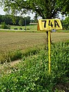
| France | utility=gas colour=yellow operator=GRTgaz ref=74A |
A big yellow marker warning about the presence of a high pressure gas | |
| Belgium | utility=oil colour=orange operator=Total ref=9.9 |
An orange aerial marker for Total pipeline network in Belgium | |
| France | utility=gas colour=yellow barrier=stile operator=GRTgaz ref=359 |
An aerial marker supported by a | |
| France | utility=gas colour=yellow material=concrete operator=GRTgaz ref=EZ 20 FI |
A pedestal indicating the presence of a high pressure gas pipeline buried below | |
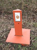
| Belgium | utility=gas colour=orange material=concrete operator=Fluxys |
A pedestal indicating the presence of a high pressure gas pipeline buried below. | |
| France | utility=gas colour=yellow operator=GRTgaz phone=0 800 24 61 02 |
A (survey) nail marker hammered in the road | |
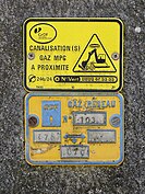
| France | utility=gas colour=yellow operator=GrDF ref=103 phone=0800 47 33 33 |
A wall mounted signage indicating the presence of a gas pipeline buried below | |
| France | utility=gas colour=white material=plastic operator=GRTgaz |
A | |
| France | utility=industrial colour=white material=plastic operator=Storengy ref=EZ 08 |
A pedestal indicating the presence of water and | |
| Belgium | utility=gas colour=orange material=plastic operator=Fluxys |
A pole indicating the presence of Fluxys gas buried below. Their top often have ref written | |
| France | utility=chemical colour=grey? operator=Elf Antar France ref=PK 373.300 phone=04 78 70 30 30 |
An aerial marker indicating the presence of an At right, a | |
| France | utility=oil colour=grey? operator=SPSE ref=PK 400.934 phone=04 42 05 01 64 |
An aerial marker indicating the presence of an At right, a pedestal marker | |
| Italy | utility=gas colour=orange |
An aerial marker indicating the presence of a gas pipeline buried below. |
Power cables
| Photo | Location | Tagging | Note |
|---|---|---|---|
| France | utility=power colour=red |
An aerial marker indicating the presence of high voltage cable buried below | |
| France | utility=power colour=red operator=EDF |
An aerial marker indicating the presence of 20 kV cable buried below | |
| France | utility=power colour=yellow operator=ESSeyssel |
A pole sign warning about the presence of a buried high voltage power cable in French country. | |
| France | utility=power colour=red operator=Enedis |
A pretty old red marker warning about the presence of buried high voltage cable beneath it. HTA means high voltage A and is defined in French norm. EDF mention, lightning sign and red colour mean it's usually about electricity network. |
Telecommunications
| Photo | Location | Tagging | Note |
|---|---|---|---|
| USA | utility=telecom colour=orange operator=GTE |
An aerial marker indicating the presence of an | |
| France | utility=telecom colour=yellow operator=France Télécom ref=1/1 phone=05 21 68 97 |
An aerial marker indicating the presence of an | |
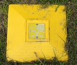
| France | utility=telecom colour=yellow operator=France Télécom |
A yellow ground marker indicating the presence of a fibre / copper cable buried below |
Fire hydrants
| Photo | Location | Tagging | Note |
|---|---|---|---|
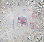
| France | utility=hydrant |
An signage indicating the location of an underground | |
| UK | utility=hydrant |
An old fire hydrant sign on the wall | |
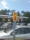
| UK | utility=hydrant colour=blue |
A blue | |
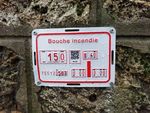
| France | utility=hydrant operator=Eau de Paris ref=751120563 |
Those plates are currently rolled out by Eau de Paris and gives several information about a near hydrant installed at stated distances from the marker. The hydrant is fed by water main of given diameter |
Voting
Voting on this proposal has been closed.
It was approved with 46 votes for and 1 vote against.
 I approve this proposal. --EneaSuper (talk) 08:00, 23 October 2019 (UTC)
 I approve this proposal. --Deizenov (talk) 17:06, 20 October 2019 (UTC)
 I approve this proposal. As always, very clear documentation and proposal making sense--PanierAvide (talk) 13:03, 12 October 2019 (UTC)
 I approve this proposal. --Don-vip (talk) 13:15, 12 October 2019 (UTC)
 I approve this proposal. --Eric B. (talk) 15:03, 12 October 2019 (UTC)
 I approve this proposal. --Mueschel (talk) 16:14, 12 October 2019 (UTC)
 I approve this proposal. --Deuzeffe (talk) 17:37, 12 October 2019 (UTC)
 I approve this proposal. I can't shake the nagging feeling that there's a class of markers this doesn't cover, but that can be added later if needed. --Carnildo (talk) 17:49, 12 October 2019 (UTC)
 I approve this proposal. --Nospam2005 (talk) 18:29, 12 October 2019 (UTC)
 I approve this proposal. --Brian de Ford (talk) 20:33, 12 October 2019 (UTC)
 I approve this proposal. --Atabaraud (talk) 21:34, 12 October 2019 (UTC)
 I approve this proposal. This is a tag I have been wanting for some time. Some marker examples I have encountered that I want to map are survey markers, memorial markers, and point-of-interest markers. Dr Centerline (talk) 00:49, 13 October 2019 (UTC)
 I approve this proposal. --Cg909 (talk) 00:57, 13 October 2019 (UTC)
 I approve this proposal. --Bobwz (talk) 01:12, 13 October 2019 (UTC)
 I approve this proposal. --Renecha (talk) 09:07, 13 October 2019 (UTC)
 I approve this proposal. --hendrik-17(talk) 18:24, 13 October 2019 (UTC)
 I approve this proposal. --Baptistemm (talk) 18:30, 13 October 2019 (UTC)
 I approve this proposal. --A well-documented proposal. PeterPan99 (talk) 19:13, 13 October 2019 (UTC)
 I approve this proposal. --Dieterdreist (talk) 20:16, 13 October 2019 (UTC)
 I approve this proposal. --Fizzie41 (talk) 22:44, 13 October 2019 (UTC)
 I approve this proposal. --Leni (talk) 11:31, 14 October 2019 (UTC)
 I approve this proposal. --AgusQui (talk) 14:23, 15 October 2019 (UTC)
 I approve this proposal. --SelfishSeahorse (talk) 19:43, 15 October 2019 (UTC)
 I approve this proposal. -- I note that in Australia the marker=ground, utility=hydrant, colour=blue maybe on either side of the road, even in the road itself. I would think the same applied in th eUK particularly in smaller residential streets. Warin61 (talk) 04:21, 16 October 2019 (UTC)
 I approve this proposal. --JacquesLavignotte (talk) 13:17, 20 October 2019 (UTC)
 I approve this proposal. --Mannivu (talk) 14:27, 20 October 2019 (UTC)
 I approve this proposal. --Gnrc69 (talk) 14:57, 20 October 2019 (UTC)
 I approve this proposal. --R2d (talk) 16:15, 20 October 2019 (UTC)
 I approve this proposal. --Chaz6 (talk) 17:22, 20 October 2019 (UTC)
 I approve this proposal. --IPelle (talk) 22:28, 20 October 2019 (UTC)
 I approve this proposal. --Doublah (talk) 01:52, 21 October 2019 (UTC)
 I approve this proposal. --XnL (talk) 04:08, 21 October 2019 (UTC)
 I approve this proposal. --Tempus (talk) 05:29, 21 October 2019 (UTC)
 I approve this proposal. --Ciampix (talk) 06:16, 21 October 2019 (UTC)
 I approve this proposal. --Anakil (talk) 07:59, 21 October 2019 (UTC)
 I approve this proposal. --Bubix (talk) 08:03, 21 October 2019 (UTC)
 I approve this proposal. --Tomtl (talk) 12:42, 21 October 2019 (UTC)
 I approve this proposal. --TheBlackMan (talk) 16:19, 23 October 2019 (UTC)
 I approve this proposal. --Michi (talk) 19:00, 23 October 2019 (UTC)
 I approve this proposal. --Thetornado76 (talk) 19:06, 23 October 2019 (UTC)
 I approve this proposal. --Highflyer74 (talk) 16:57, 24 October 2019 (UTC)
 I approve this proposal. --TheDutchMan13 (talk) 23:35, 24 October 2019 (UTC)
 I approve this proposal. --Lmagreault (talk) 13:26, 25 October 2019 (UTC)
 I approve this proposal. --Rza31 (talk) 16:45, 25 October 2019 (UTC)
 I oppose this proposal. I believe this has no real use and makes the map more complicated/dense/compact for no real reason. --Empers (talk) 19:41, 25 October 2019 (UTC)
 I approve this proposal. --Marc marc (talk) 20:48, 25 October 2019 (UTC)
 I approve this proposal. --Gendy54 (talk) 16:27, 26 October 2019 (UTC)

