Tag:power=plant
| Description |
|---|
| An industrial facility where power (electricity, useful heat, biogas) is produced by individual power generator units. |
| Rendering in OSM Carto |

|
| Group: power |
| Used on these elements |
| Useful combination |
|
| See also |
| Status: approved |
| Tools for this tag |
|
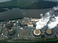
A power plant (601-03-01, also referred to as a generating station, power station, or powerhouse) is an industrial, large-scale facility for the generation of energy (normally electricity, but can include other forms). Power plants may also be responsible for storing energy: in the case of electric power plants this is most commonly through hydroelectric pumped storage, although battery storage plants are becoming more common.
Smaller-scale distributed power generation (such as rooftop solar panels, micro-hydro, and wind turbines not part of a larger wind farm) should not be tagged as a power plant, but with the power=generator tag alone. As a guideline, generators producing less than 1 MW should not normally be tagged as power plants.
Recommended tags
| Key | Value | Comment | Recommendation |
|---|---|---|---|
| power | plant | Defines this area as a power plant. | Basic tag |
| name | name | The name of the plant. | Recommended |
| operator | operator | Name of the company that operates the power plant. | Recommended |
| start_date | date (YYYY-MM-DD) | Date when the construction was finished, using |
Recommended |
| landuse | industrial | Most enclosed power plants are industrial facilities | Strongly recommended for enclosed plants if not already inside a larger landuse=industrial |
| plant:source | energy sources used | List of energy sources used by individual generators within the plant. Multiple fuels should be separated by semicolons (example: plant:source=coal;gas) | Recommended |
| plant:method | method | The method by which the power plant works | Optional |
| plant:output | rated output | The rated output of the whole facility, often available in operator public documentation. The tagging is consistent with generator:output=*: a co-generation plant would have for example plant:output:electricity=* and plant:output:steam=* keys. They accept numeric values or yes if the exact rating is unknown. | Recommended |
| plant:storage | rated storage capacity | The amount of energy the plant can store. | Recommended for storage plants |
| wikidata | Wikidata ID | Allows for more structured citations for plant attributes and linking to other databases. Also used to render the Infobox map on English Wikipedia. | Recommended for plants having Wikidata page |
Plants under construction
If a power plant is under construction, the construction: lifecycle prefix should be added to the power tag (i.e. construction:power=plant instead of power=plant). This prefix should not be added to any other tags. The landuse=construction tag should also be used for enclosed power plants.
Power plants should be tagged as under construction until any part of the plant has commenced operation (it is common for wind farms to start exporting electricity before they are fully completed).
Plants under construction are visible on OpenInfraMap.
Tagging guidelines
Power plants can be roughly divided into two types:
- Enclosed power plants, which are facilities on a dedicated piece of land, commonly fenced off. These include conventional coal, gas, and nuclear plants, as well as many solar farms. Offshore wind farms are also included in this category.
- Dispersed power plants, which are spread across an area used for other purposes. Onshore wind farms and hydroelectric plants are common examples, but large rooftop solar farms may also be tagged as a dispersed power plant.
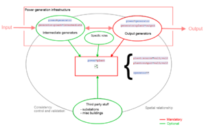
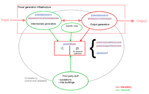
This section provides guidance on how to tag these different types of plants. For more information on the reasoning behind this tagging scheme, see the power generation refinement proposal.
Enclosed power plants
Most conventional power plants consist of a single, fenced, area which is dedicated to the power plant. The power=plant should be tagged as an area ![]() around the power plant perimeter. Within this area, there will normally be one or more generators, and possibly a substation. In some cases a power plant may be split between two or more separate areas. These can be mapped as a multipolygon
around the power plant perimeter. Within this area, there will normally be one or more generators, and possibly a substation. In some cases a power plant may be split between two or more separate areas. These can be mapped as a multipolygon ![]() .
.
Offshore wind farms are also normally mapped as areas, not as dispersed power plants. The area around the wind farm may have restrictions on navigation, so this area can also be tagged with the appropriate Seamark tags.
Multiple operators
As discussed on tagging mailing list, power plant areas and perimeters would be pretty hard to map when many different operators share the same location on a generation site. A simple rule to make the distinguishing between operators is to create a separate area for each one. Two or more power plants would directly be created. In general, only one company is operating a power plant, so if two or more operators are present on a site, we could have two different power plants or two different components for power generation. In all cases, we mustn't map it in one single area. Each area will have different operator=* values and potentially as many name=*. The key point is still the ownership of the land occupied by the power plant. Furthermore and often, room is reserved besides actual power plants for future extensions. This room should be included in the power plant area if it's fenced along with the main production site. Finally, Relation:multipolygon ![]() doesn't match these operator consideration since operator distinguishing must be done.
doesn't match these operator consideration since operator distinguishing must be done.
Dispersed power plants
Some power plants (such as onshore wind, tidal, hydroelectric and some photovoltaic) may consist of a group of structures (generators, as well as possibly substations, pipelines, or dams) which are spread across a large area. The land between these generators is not fenced, and may be used for agricultural or other purposes.
Each generator (such as a turbine or group of photovoltaic panels) should be tagged as power=generator. These generators are then combined together in a relation with type=site. Relations should only be used when no perimeter surrounds the generators.
Dispersed power plants are not rendered on the standard tile layer, but they are shown on OpenInfraMap.
Examples
This key may be hard to use or understand. Take a look to all those quick examples to find out how it's simpler than it seems ;)
Solar farm
| Power plant | Tagging | Description | OSM ref |
|---|---|---|---|
| Verrerie solar power plant, France |
|
A 34 ha solar farm producing 24 MW of electricity when sun comes up in south of France. With a little aerial imagery help, generators are taken as groups of solar cells for sake of simplicity. It is actually possible to use The relation accepts two closed and fenced perimeters, all generators and a transmission substation connecting to the power grid |
3501886 |
Offshore wind
| Power plant | Tagging | Description | OSM ref |
|---|---|---|---|
| Burbo Bank Offshore Wind Farm, UK |
|
Burbo Bank is an offshore wind farm, which is tagged as an area to allow the appropriate Seamark tags to be used. The individual wind turbines are tagged with power=generator within this area. | 327949356 |
Onshore wind
| Power plant | Tagging | Description | OSM ref |
|---|---|---|---|
| Clyde Wind Farm, UK |
|
The Clyde wind farm is a large onshore wind farm consisting of 206 turbines spread around a large area. This dispersed power plant is tagged as a relation. | 6949277 |
Fossil fuels
| Power plant | Tagging | Description | OSM ref |
|---|---|---|---|
| Vaires-sur-marne combustion power plant, France |
|
Vaires-sur-Marne used to host a coal power plant which was decommissioned and then destroyed to reuse the site for cleaner combustion turbines. Currently, 3 combustion turbines of 185 MW each feed the power 225 kV power grid in the Paris area. | 260698234 |
Hydroelectric
For more information on tagging hydroelectric plants, see the approved proposal for hydro power mapping.
| Power plant | Tagging | Description | OSM ref |
|---|---|---|---|
| Hoover Dam, Nevada, USA |
|
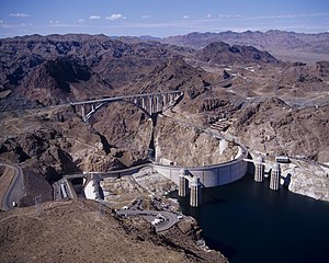
Boulder dam is a famous dam built in early 1900's next to Las Vegas, USA. A substation collects the 19 generators power as to transmit to the power grid. The lake also allows authorities to feed nearby towns with fresh water. Since each component isn't linked by a fenced perimeter, a relation is used to make this power plant alive in OSM. | 1652352 |
| Génissiat Dam, France |
|
Genissiat dam is a run-of-the-river power plant relying on a big concrete structure to get a 23 km long lake on the Rhone river. It is hosting 6 power generators inside the dam connected to penstocks and outlets ducts. The waterway corresponding to river is diverted in dedicated ways corresponding to penstocks intakes. Have a look to the map to get more information
As many major generator and plants in Europe, Genissiat EIC code is given with ref:EU:ENTSOE_EIC=* |
80667335 |
| Roselend_Dam, France |
|
Here is a wide electricity production site built in French Alps. Water is stored in a huge lake and goes through 60 km long tunnels ending into the La Bathie underground power plant.
The choice is made to bring all the stuff inside a unique relation instead of the single power plant cavern. The six Francis turbines are currently under maintenance to step up their output to 100 MW of electricity each. Power is sent to the power grid by the Albertville power substation |
4500049 |
Nuclear
| Power plant | Tagging | Description | OSM ref |
|---|---|---|---|
| Gravelines Nuclear power plant, France |
|
Gravelines is the most powerful nuclear electricity generation site in France. 6 units can be found there, with 910 MW output each.
Nuclear reactors are split into two map features with power=generator on the building As many major generator and plants in Europe, Gravelines EIC code is given with ref:EU:ENTSOE_EIC=* |
85203514 |
See also
- power=generator, a device which converts one form of energy to another, for example, an electrical generator.
- power=substation, a facility which controls the flow of electricity in a power network with transformers, switchgear or compensators.
- Proposed features/Power generation refinement, the approved proposal.


