Proposal:Hydropower water supplies
| Hydroelectric water supplies | |
|---|---|
| Proposal status: | Approved (active) |
| Proposed by: | fanfouer |
| Tagging: | waterway=*
|
| Applies to: | |
| Definition: | Propose to map hydropower water adduction systems involving tunnels, canals, ducts and pipes using waterway=pressurised and man_made=pipeline when appropriate
|
| Statistics: |
|
| Draft started: | 2017-10-13 |
| RFC start: | 2017-12-02 |
| Vote start: | 2018-03-04 |
| Vote end: | 2018-03-18 |

Rationale
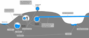

Hydropower systems are intended to convert energy from moving or pressurised water into electricity or mechanical rotating energy. There are many kind of such power plants and sometimes, pretty big infrastructure is needed to carry water from intakes to turbine generators. High pressure pipes leading to generators are necessarily shielded and are called penstocks.
When overground, penstocks are often huge and can be great orientation ways in landmarks.
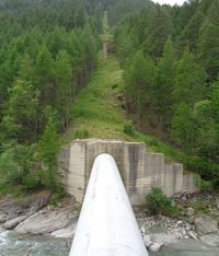
It's not currently possible to involve facilities which carry water in topological paths using waterway=*. It's an issue since such plants need plenty of water and use to divert a large part of rivers inside penstocks, as seen on picture beside: a whole overground canal goes into 3 penstocks but water disappear unless we look for pipelines.
A tagging model which associate conduit and content will be more clear and versatile to map the diversity of water flow situations.
Thus, this proposal will try to associate waterway=* and man_made=* (or tunnel=*, canal=* keys) for sake of consistency.
The main advantage is to know where water is flowing without taking care of containers like tunnels, canal or whatever. Currently you are forced to.
It's not necessary to know how a hydroelectric power generator works to understand this proposal. It's all about tunnels, canals and pipes.
Definitions
- Open-channel flow : The situation when water flows freely with a free surface outdoor or inside a pipe or tunnel.
- Pipe flow : The situation for a fluid to flow without any free surface in a closed space like pipe or tunnel. The main difference with open-channel flow regime is the pressure the fluid applies on the conduit.
- Canal: A man made structure intended to carry useful water whatever its purpose from a waterbody to another.
- Aqueduct: A system mainly designed for irrigation composed of canals, tunnels, pipes or any man made structure.
- Penstock: A conduit taking water from a river, lake or tunnel and leading it to power turbines or mills at a high pressure as to maximize mechanic power transmission.
- Spillway: A construction related to dams allowing overflow water to go downstream. A spillway operates only in special conditions and shouldn't be walked by humans.
- Nominal diameter: The nominal size of pipes, as defined in ISO 6708 norm. It often correspond to internal diameter, but at some precise temperature and pressure conditions.
- Mill race: The whole way the water goes down to feed a mill (or a turbine), from the intake to the release.
- Head race: The way the water follows from intake to a mill (or a turbine)
- Tail race: The way between a mill (or a turbine) and the water release into natural environment.
Proposal
Pressurised waterway (pipe flow only)
Usually, waterway=* key refer to free flowing water situations, like rivers and streams, inside tunnels or outdoor. It also needs a value to refer to pipe flowing facilities when raw water from lakes and rivers runs into tunnels and pipelines.
The point is to make a continuation of rivers inside pipelines and involve pipe flow water paths into the already big waterway=* hydrographic system.
It's not possible to always involve pipelines into river relations since water can be sent miles away in other watershed through tunnels.
waterway=pressurised will be available to tag any pipe flow feature like water tunnels, penstocks and siphons where water flows without any air.
Furthermore, it may be useful for speleologists and natural underground rivers/siphons out of this proposal scope.
Since waterway=canal is a feature which carries useful water while waterway=drain is intended to remove superfluous water, it is also proposed to tag all free flow water transmission/adduction paths as waterway=canal. Several other tags will be used depending of configurations (free space, tunnels) in which the canal takes place.
There are currently many underground waterways tagged with waterway=canal and this proposal point will prevent them to be edited.
This would lead us to this classification of waterways :
| Free flow | Pipe flow | ||||
|---|---|---|---|---|---|
| Man made | Open air | Culvert | Tunnel | Pipeline | |
canal (useful water) |
pressurised
| ||||
ditch
| |||||
drain (superflous water)
| |||||
| Natural | Open air | cave | Siphon | ||
river |
pressurised
| ||||
stream
| |||||
Penstocks
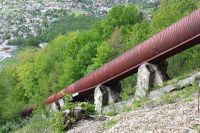
Penstocks are tilted pipes taking water from a high elevation to power turbines. Such pipes should be mapped with existing man_made=pipeline + substance=water + usage=penstock.
Those structures are particular and usually shielded to handle large amount of water flowing at a high pressure. The most the elevation difference is high, the most will be the pressure.
waterway=pressurised applies here.
Penstocks can be whether overground or underground (location=*). Underground penstocks can be directly dug in bedrock or located inside a human accessible tunnel. tunnel=yes should only be used for human accessible tunnels hosting pipes. If not, don't use tunnel=* key.
| Key | Value | Comment | Recommendation |
|---|---|---|---|
| waterway | pressurised |
This is always a pipe flow waterway | mandatory |
| man_made | pipeline |
A penstock is always a pipeline | mandatory |
| substance | water |
A penstock always carries water | mandatory |
| usage | penstock |
No comment | mandatory |
| location | <penstock location> | Depending of environment and ground shape, penstocks can be overground or underground | recommended |
| diameter | <penstock nominal diameter> | The nominal diameter (ISO 6708) of the pipe | optional |
| pressure | <nominal penstock pressure> | The nominal pressure the penstock is designed for | optional |
| material | <penstock material> | The material used to build the pipes. | optional |
| operator | <penstock operator> | Name of the company operating the penstock | recommended |
| direction | both or nothing |
Only use both for pumped storage power plants where water can go up & down |
optional |
Penstocks can be part of Relation:waterway with side_stream role.
Headraces tunnels and canals
Penstocks can be really short, leading water from a lake behind a dam to turbines, or kilometres long. Water can go through complex systems of horizontal unshielded galleries (upstream from penstocks) with pipe or free flow operation and they are called headraces.
For underground situations, mappers will choose between tunnels or pipeline, and will only use both on the same object when the pipeline is inside a tunnel.
As said before, it may be possible to involve water feeding infrastructure in Relation:waterway with side_stream role only if all water is took and released in the same river. It's not always the case and waterway=* graph have to be extended with or without waterway relation membership.
Free flow tunnels

Free flow tunnels use to be mapped with waterway=canal (but not exclusively) and it is proposed to add tunnel=flooded + usage=headrace. This is specific for power generation feeding and usage=transmission should be used otherwise.
waterway=canal sounds to be the most suitable key since a canal is intended to carry useful water while a drain is built to remove superfluous water and aqueduct refer to the whole water transmission system which the canal can be part of.
There is no need to add pressure=* key since water always flows at atmospheric pressure.
Water always goes in the way direction and no direction=* have to be used on such features. Reverse water flowing direction would require to make the tunnel pressurised.
Pipe flow tunnels

Such tunnels can be whether slightly pressurised or operate at atmospheric pressure. Leading intakes are always below water level as to not allow air to get inside. pressure=* is used to give the nominal static pressure the tunnel is designed for.
| Key | Value | Comment | Recommendation |
|---|---|---|---|
| waterway | pressurised |
This is pipe flow waterway | mandatory |
| tunnel | flooded |
Pipe flow tunnels are always full of water and then not walkable in operation | mandatory |
| usage | headrace for power generation only, transmission otherwise |
Headraces are for power plants only, other tunnels are intended for water transmission | mandatory |
| location | underground |
A tunnel is underground, don't you ? | mandatory |
| diameter | <pipe nominal diameter> | The nominal diameter (ISO 6708) of the pipe | optional |
| pressure | <nominal waterway pressure> | The nominal pressure the waterway is designed for | optional |
| operator | <pipeline operator> | Name of the company operating the pipeline | optional |
| direction | both or nothing |
Only use both for pumped storage power plants where water can go up & down |
optional |
Pipelines
Water can be find flowing in a pipeline when not in a proper tunnel or even overground.
Assuming pipe flow headraces pipelines are different from penstocks, the first will be mapped with usage=headrace instead of usage=penstock.
man_made=pipeline and (tunnel=flooded, tunnel=culvert) are set as incompatible.
| Key | Value | Comment | Recommendation |
|---|---|---|---|
| waterway | pressurised |
This is pipe flow waterway | mandatory |
| man_made | pipeline |
It's a pipeline | mandatory |
| usage | headrace for power generation only, transmission otherwise |
Headraces are for power plants only, other pipelines are intended for water transmission | mandatory |
| substance | water |
The pipeline carries water | mandatory |
| location | <pipe location> | Pipeline location | mandatory |
| diameter | <pipe nominal diameter> | The nominal diameter (ISO 6708) of the pipe | optional |
| pressure | <nominal waterway pressure> | The nominal pressure the waterway is designed for | optional |
| tunnel | yes |
Only used to set the pipeline hosted in a permanently human accessible tunnel. See below | optional |
| operator | <pipeline operator> | Name of the company operating the pipeline | optional |
| direction | both or nothing |
Only use both for pumped storage power plants where water can go up & down |
optional |
Human accessibility, pipelines vs tunnels

It's not unusual to find actual pipelines installed in dry tunnels where technician can walk along the pipe. Otherwise, tunnels are full of water and are never human accessible when in operation.
Please only use tunnel=yes when the pipeline is human accessible in operation. tunnel=flooded and man_made=pipeline are set as incompatible.
Even if tunnel=* is recommended to render such underground facilities, a pipeline is not a tunnel, both key are used if and only if pipeline is inside a tunnel and a specific rendering solution will have to be found for waterway=pressurised.
Finally, all human accessible tunnels should get access=private (since pretty all of them have access restriction signs on their access gates) and flooded ones should be tagged with tunnel=flooded.
Pumped-storage power plants
All plants get powered by water going down from intakes to tubrines but some of them can also use power grid electricity to pump water between two lakes at different elevations.
In this particular situation, all pressurised tunnels and penstock (and never free flowing tunnels or open air canals) should get direction=both because water can go alternatively up and down.
Overground canals
When overground, water flows in free surface canals, then waterway=canal is appropriate.
Such canals are intended for a particular purpose, different from navigation. When the canal is located between intake and mill/turbine, usage=headrace should be added while usage=tailrace is dedicated for sections between mill/turbine and water release.
Surge tanks

Surge tanks are useful to dissipate the power water is applying to pipes and tunnels when a valve is closed (sometimes brutally).
Depending of upstream (only, not downstream penstocks) tunnels length and diameter, they can be pretty huge shafts like 200m of depth and 20m of diameter - often found in the middle of nowhere.
Overground building can exist sometimes and it may be useful to add name=Valve chamber on it.
Surge tanks is a concept related to fluid flows, not specific to penstocks.
As strategic function of a pipeline system, often at the start point of penstocks, we can map them in OSM with pipeline=surge_tank on a node only, like valves.
Even if such tanks can be huge shafts or chimneys, pipeline=surge_tank should be used on a pipeline node placed at the position of the tank. Visible infrastructure can be tagged with man_made=shaft or man_made=chimney since it can be complex buildings or construction which don't need to be linked to pipeline directly.
| Key | Value | Comment | Recommendation |
|---|---|---|---|
| pipeline | surge_tank |
It's a pipeline surge tank | mandatory |
| location | <tank location> | Location of the surge tank. Can be outdoor, underground | recommanded |
| diameter | <tank diameter> | The internal diameter of the tank | optional |
| operator | <surge tank operator> | Name of the company operating the surge tank | optional |
Water intakes / release points
For topological accuracy, penstocks, tunnels, or any waterway=* feature should be connected to natural input rivers, streams or canals. The same waterway=* values should be used on additional connections than on source water feature.
Such connection flows have to be added to Relation:waterway relations with side_stream role.
Usually a waterway=dam is built to direct water inside tunnel or pipes instead of natural riverbed.
Spillways
Spillways need to be distinguished from actual streams or river due to very occasional streams going along it. There is additionally a potential danger for persons crossing or located downstream of such ways.
Spillways aren't intended to preserve rivers flow rate and are only active when special situations occurs upstream of dams. Then it's proposed to map them with waterway=canal + usage=spillway + intermittent=yes and add it to waterway relation with side_stream role.
Pages to be edited
waterway=pressurised: Create the page, dedicate this value to pipe flow waterways- Waterways : Add pressurised in possible values
man_made=pipeline: Edit the page and add headrace as possible usagepipeline=surge_tank: Create the pagewaterway=spillway: Edit the page, indicate this value shouldn't be used any more, remove the value from waterway featurestunnel=*: Create the page, add flooded as possible value.usage=*: Edit the page, add spillway, headrace, tailrace and transmission as possible waterway values.- Relation:waterway : Add water management features as member of such relations
Examples
Headraces
Also referred to as "millrace" or "mill race" (in British English at least).
| Photo | Tagging | Note |
|---|---|---|
 |
|
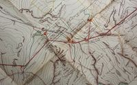
Horizontal tunnels carrying water from intakes to penstocks. Such ways have a pipe flow regime, their inlet are always below the water level and no air can get inside. |
 |
|
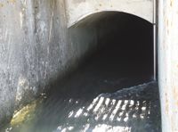
A headrace tunnel works at atmospheric pressure and water have a free surface while flowing inside. Its inlet is designed to be always above water level and air can get inside too. |
 |
Headrace overground canal feeding penstocks of a power plant | |
 |
|
The most complete case with a headrace pipeline hosted in a human accessible tunnel in operation. This is the only situation where man_made=pipeline is used in combination with tunnel=* on the same way.
|
 |
On all parts, use:
operator=...
On the bridge part, use:
On the underground part, use:
|
A big siphon allowing water to cross a valley. Only half side is visible on the picture, tunnels or pipelines are connecting each side at equivalent altitudes. The siphon is a pipe flow waterway. |
Penstocks
| Photo | Aerial view | Tagging | Note |
|---|---|---|---|
 |
-- |
|
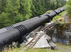
Metallic penstocks feeding a power plant down the mountain. No air can get inside and water goes pipe flow |
 |
-- |
|
Vertical shafts are shielded as pipeline without tubes. Pipes are connected upstream and downstream.
See the two vertical shafts on the power plant digital model and some pics of how it was built with a raise drill machine.
|
Water intakes
| Photo | Aerial view | Tagging | Note |
|---|---|---|---|
 |
-- |
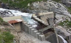
On the dam, draw a |
Such a dam is intended to divert part of a river into a tunnel leading to power plant turbines. About 3.5 m3 per seconds go into the intake while only 0.6 remain in the natural environment.
|
Surge tanks
| Photo | Aerial view | Tagging | Note |
|---|---|---|---|
 |
-- |
At the center of the shaft or chimney, add a node and use :
|
A chimney is installed above the pipeline it is supposed to protect |
 |
-- |
At the center of the shaft, add a node and use :
|
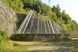
Here is an underground shaft acting as a surge tank for a penstock located 170 metres below. The shaft outlet is about 18 metres wide |
Spillways
| Photo | Aerial view | Tagging | Note |
|---|---|---|---|
 |
-- | Draw a waterway=canalusage=spillway |
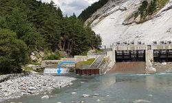
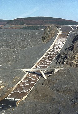
The spillway on the picture is active but it's not always true. |
 |
Voting
- Log in to the wiki if you are not already logged in.
- Scroll back down and click "Edit source" next to the title "Voting". Copy and paste the appropriate code from this table on its own line at the bottom of the text area:
| To get this output | you type | Description |
|---|---|---|
{{vote|yes}} --~~~~
|
Feel free to also explain why you support the proposal! | |
{{vote|no}} reason --~~~~
|
Replace reason with your reason(s) for voting no. | |
{{vote|abstain}} comments --~~~~
|
If you don't want to vote yes or no but do have something to say. Replace comments with your comments. |
~~~~ automatically inserts your name and the current date.For more types of votes you can cast, see Template:Vote. See also how vote outcome is processed.
21 out of 27 votes (78%). This proposal is accepted
 I approve this proposal. --EneaSuper (talk) 09:25, 11 March 2018 (UTC)
 I approve this proposal. --Ashtez (talk) 15:18, 10 March 2018 (UTC)
 I approve this proposal. --Nospam2005 (talk) 20:44, 4 March 2018 (UTC)
 I approve this proposal. --Atabaraud (talk) 22:41, 4 March 2018 (UTC)
 I approve this proposal. Fanfouer (talk) 00:19, 5 March 2018 (UTC)
 I approve this proposal. Crochet.david (talk) 10:42, 5 March 2018 (UTC)
 I oppose this proposal. The objections I explained in my previous vote and on the talk page still apply, as the proposal has not changed in those respects. It's impossible for a mapper to determine whether (or which parts of) an underground waterway is pressurized, and even when you know for some reason, you can use the pressure=* tag for that information. I am also disappointed that you are ignoring my expertise as a cave serveyor. This proposal is even more problematic than the previous version, as you added a tunnel=flooded tag which conflicts with other values such as tunnel=culvert. I am ok with the usage=* tags, and I suggest to split the proposal so we can discuss and vote on them separately and get a clearer picture on what tags we are voting on. --Fkv (talk) 12:06, 5 March 2018 (UTC)
 I have comments but abstain from voting on this proposal. Abstaining for now but more inclined against, I think this needs more work. Trying to cover natural features in this proposal makes it too complicated, might be better if you would focus on manmade hydropower. Using waterway=pressurised with natural water flows is nonsense. Whether an underwater flow is pressurized depends on whether it is completely full of water and this is naturally changing. Sometime sections of it will be pressurized, sometimes nothing or all. Also the rationale for waterway=pressurised is very weak. Why should be waterway=pressurised mandatory for pipes? Some pipes may not be pressurized. RicoZ (talk) 13:43, 5 March 2018 (UTC)
 I approve this proposal. --Simon BRL (talk) 15:38, 5 March 2018 (UTC)
 I approve this proposal. --Dr Centerline (talk) 03:12, 6 March 2018 (UTC)
 I approve this proposal. --Adamfranco (talk) 15:06, 6 March 2018 (UTC)
 I approve this proposal. --Renecha (talk) 00:33, 7 March 2018 (UTC)
 I approve this proposal. It is a very complete page. Objections raised by Fkv are solvable. Tunnel=culvert and tunnel=flooded aren't in conflict because they apply to different objects, we have only to well document the two cases. Other objections raised in discussion page aren't a problem according to me.--Viking81 (talk) 07:56, 7 March 2018 (UTC)
 I oppose this proposal. - see RicoZ and Fkv Mateusz Konieczny (talk) 16:36, 7 March 2018 (UTC)
 I approve this proposal. --Waldhans (talk) 23:19, 7 March 2018 (UTC)
 I approve this proposal. --HillWithSmallFields (talk) 14:44, 9 March 2018 (UTC)
 I oppose this proposal. "waterway=pressurised" makes no sense whatsoever to me. The waterway tag has historically described the type of waterway and whether it is pressurised or not is orthogonal to that. By all means propose new tags but don't please subvert the meaning of existing ones. --SomeoneElse (talk) 13:23, 10 March 2018 (UTC)
 I approve this proposal.
 I approve this proposal. --Michi (talk) 22:07, 10 March 2018 (UTC)
 I approve this proposal. --Atalanttore (talk) 10:48, 11 March 2018 (UTC)
 I approve this proposal. --Dromedar61 (talk) 19:21, 11 March 2018 (UTC)
 I oppose this proposal. --Adavidson (talk) 04:58, 13 March 2018 (UTC)
 I approve this proposal. --Highflyer74 (talk) 11:20, 15 March 2018 (UTC)
 I oppose this proposal. For the same reasons as RicoZ and SomeoneElse. In my opinion,
 waterway=pipeor similar would be more consistent with the existingwaterway=*values. (PS: I'm sorry for opposing this proposal seeing that you put so much effort in its documentation.) --SelfishSeahorse (talk) 18:29, 15 March 2018 (UTC) I approve this proposal. --Buchanan (talk) 18:54, 15 March 2018 (UTC)
 I approve this proposal. --Helmut Kauer (talk) 10:56, 16 March 2018 (UTC)
 I approve this proposal. I understand the objections, but there are no better approaches to solve the principle problem --Schröcker (talk) 19:09, 18 March 2018 (UTC)
Post-vote cleanup
Here are resources related to post-vote cleanup :
- JOSM preset update ticket #16147
- iD preset update issue 4957