ViaLibera - Other languages
Complete description
The complete description of the project is provided in the Italian wiki page.
What is ViaLibera?!
ViaLibera?! - Project for the mapping and evaluation of the accessibility of the Municipality of Milan 9
The project, which started in October 2019, foresees the verification and mapping of the accessibility of three large areas of City Hall 9 in Milan, identified because they are considered strategic for the presence of important services (such as train/subway/university/hospital), with the indication of the critical points to be modified to allow all citizens, people with motor disabilities, elderly people, mothers with pushchairs, to access services easily.
The objective is to define a model of intervention that can also be exported to the other Municipalities of Milan and to other cities, which foresees the use of freely available or at least low-cost, open-source technologies and the active involvement of citizens, in order to develop a shared culture of accessibility as a benefit for everyone.
The project foresees:
- The use of a shared, participatory, and freely accessible platform, both for enrichment and consultation: in particular, it was decided to use OpenStreetMap, which is a standard for the international technical-scientific community,
- The design of the optimal mapping methods for the purposes of the project,
- The participation of people with motor disabilities as evaluators of accessibility and experimenters of mapping methods,
- Training by accessibility experts, all evaluators,
- The detection of the needs of different categories of citizens: mothers with small children, elderly people..,
- The involvement in the surveys of students of the Politecnico di Milano, students of some high schools, and volunteers of associations in the area,
- The awareness of the owners of the shops in the three areas, so that they understand the economic benefits of being accessible to all and are thus encouraged to improve the accessibility of their shops,
- The dissemination of mapping methods to the community, so as to generate a virtuous path that allows the continuous enrichment of databases,
- Moments of public presentation of the results to different targets (students, university students, citizenship)
Via Libera?! is a project promoted by Spazio Vita Niguarda Onlus, Ledha Milano, Politecnico di Milano and AUS Niguarda Onlus with the participation of Municipio 9, AMAT and CRABA, realized thanks to the contribution of Fondazione di Comunità Milano Onlus, as part of the Bando 57 2019 edition.
Tagging schema
The original reference for the project was the page in [1]. This is the translation to make it worldwide shareable.
Sidewalks
Crossings
Scheme used for crossings
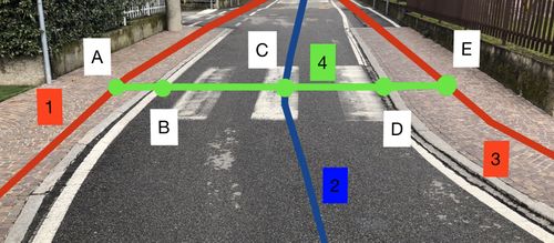
The scheme used to map the crossings is the one shown in the figure. Each crossing is considered to be composed of 5 nodes (A-B-C-D-E) which form the way (4). Ways (1) and (3) represent the sidewalks, way (2) represents the road. More complex crossings are always considered to consist of 5 nodes.
Nodes (B) and (D) represent kerbs.
Crossing
Tag for way (4) and node (C).
Choose from one of the following options for intended users and type.
The following tags will be indicated only on the way (4).
Traffic light crossings
Cordoli
Tags for nodes (B) and (D).
Examples of kerb typology
Barriers
Schema used to insert barriers into pavements
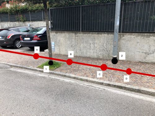
The barriers are mapped as nodes external to the sidewalk (1) and (2) as in the figure and the sidewalk is divided into segments (before A, A-B, B-C, C-D, after D) each of which is mapped following the scheme described previously.
Nodes (1) and (2) can represent the following elements.
Manhole
Vertical signs
Planter
Barrier block
Telecom Street cabin
Streetlamp
Tree
Deep isolated hole
Tag not to be inserted on the node but on the way segment.
Bollard
Wast basket
Nel caso in cui sia fisso e non rimuovibile.
Fire hydrant
Parking lots
Total area
Single stall
Complex examples
Crossing
Crossing tag table
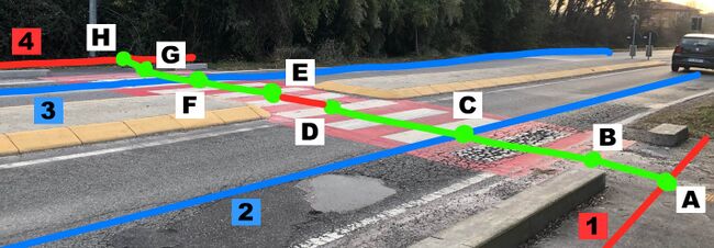
Pavements are shown in red, crossings in green, tram tracks in black and roads in blue.
Barriers
Table tag barriers on pavement

Schema used to insert barriers into pavements
Passo Carraio
Passo Carraio
Schema used for mapping passi carraoio
Crossing with rest area
Crossing with rest area
Schema used for crossing with rest area


