Template:Zh-hant:Map Features:landuse
Jump to navigation
Jump to search
土地利用 (landuse)
用來標記並描述土地的用途,詳見Landuse。
| 關鍵字(key) | 值 (value) | 元素 (element) | 敘述 (desc) | 圖例 (render) | 照片 (photo) | |
|---|---|---|---|---|---|---|
Common landuse key values - developed land | ||||||
| landuse | commercial | 商業區。以辦公或商業區域為主要用途。 |  |
 | ||
| landuse | construction | 施工中的未完工區域,完工後應改為其它用地。 |  |
 | ||
| landuse | education | An area predominately used for educational purposes/facilities. |  |
 | ||
| landuse | fairground | A site where a fair takes place |  | |||
| landuse | industrial | 工業用地,以工坊、工廠或倉庫或相關工業設施為主要用途。 |  |
 | ||
| landuse | residential | 住宅區,以房屋或公寓為主。
|
 |
 | ||
| landuse | retail | 商店/零售。以商店與其附屬設施(如停車場、通道、草地等)為主。 |  |
 | ||
| landuse | institutional | Land used for institutional purposes, see office=government, office=ngo, office=association, amenity=social_facility and their associated infrastructure (car parks, service roads, yards and so-on) inside the area. |
 | |||
| 關鍵字(key) | 值 (value) | 元素 (element) | 敘述 (desc) | 圖例 (render) | 照片 (photo) | |
Common landuse key values - rural and agricultural land | ||||||
| landuse | aquaculture | Warning: currently, there is no convention on the exact meaning of this tag. Therefore, it makes sense to treat it like "boundary of aquaculture" (without implication of water body), which means, water body should be tagged by its own, using |
 | |||
| landuse | allotments | 地方居民的私人菜圃、花圃。 |  |
 | ||
| landuse | farmland | 農業用地。以耕作和畜牧(動物養殖與糧食作物、蔬菜、花卉栽種等)為主要用途。 |  |
 | ||
| landuse | farmyard | 農業設施,農業相關設施如農舍、農莊、莊園、棚架、馬場、倉庫、農機具車庫、飼料倉庫等,與該設施相鄰之樹林。 |  |
 | ||
| landuse | animal_keeping | An area of land that is used to keep animals, particularly horses and livestock. |  | |||
| landuse | flowerbed | An area designated for flowers |  |
 | ||
| landuse | forest | 林業用地。供林場管理與保育用途。(Other languages)天然林請改用natural=wood。
|
 |
 | ||
| landuse | logging | An area where some or all trees have been cut down |  | |||
| landuse | greenhouse_horticulture | 溫室,以溫室栽培植物的土地利用。 |  |
 | ||
| landuse | meadow | 牧草地,以栽種草本植物或牧草等作物(如甘蔗、玉米或牧草)為主要用途。 |  |
 | ||
| landuse | orchard | 果園。栽種供食用為目的樹木或灌木。 |  |
 | ||
| landuse | plant_nursery | 育種苗圃,人為栽培新品種植物。 |  |
 | ||
| landuse | vineyard | 葡萄園 |  |
 | ||
| 關鍵字(key) | 值 (value) | 元素 (element) | 敘述 (desc) | 圖例 (render) | 照片 (photo) | |
Common landuse key values - traffic and transportation | ||||||
| landuse | depot | An area used as a depot for e.g. vehicles (trains, buses or trams). Consider using rather standard landuse tags like landuse=railway, landuse=commercial, landuse=industrial, with subtag like industrial=depot.
|
 | |||
| landuse | garages | 停車用地。常以磚或鐵皮建造,多屬於私人停車廠商經營。 |  |
 | ||
| landuse | highway | Area of land used for a highway, including all auxiliary areas like associated footways, verges and ditches. |  | |||
| landuse | port | 濱海工業區(貿易交通受管制)。 |  | |||
| landuse | railway | 鐵路用地。多不開放公眾使用,如車廠/車庫。 |  |
 | ||
| 關鍵字(key) | 值 (value) | 元素 (element) | 敘述 (desc) | 圖例 (render) | 照片 (photo) | |
Common landuse key values - waterbody | ||||||
| landuse | basin | 流域/集水區。 搭配 basin=*標註集水區種類。
|
 |
 | ||
水庫/蓄水池。可能為覆蓋或未覆蓋,覆蓋請參考man_made=reservoir_covered。water=reservoir為替代用法。
|
 |
 | ||||
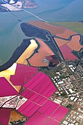
| landuse | salt_pond | 鹽田,用於讓海水蒸發以取得鹽的土地。 |  |
 | ||
| 關鍵字(key) | 值 (value) | 元素 (element) | 敘述 (desc) | 圖例 (render) | 照片 (photo) | |
Other landuse key values | ||||||
| landuse | brownfield | 計畫開發區域,該區建物已拆除或清除。 |  |
 | ||
| landuse | cemetery | 墓地、墳場。能添加標籤 religion=*標註墓地的宗教類別,可選用的類別參見place of worship頁面)。小型墓地(如教堂等設施附屬墓園)得使用 amenity=grave_yard替代。
|
 |
 | ||
已廢止。請改用boundary=protected_area、protected_area=*。
|
||||||
| landuse | grass | 綠地,人工種植、維護的草皮。 種植牧草、草本植物的土地請改用 landuse=meadow、landuse=pasture。注意此標籤實際為土地覆蓋型態,而非土地利用型態,經提議刪除的標籤。 |
 |
 | ||
| landuse | greenfield | 預定建造建物的閒置空地,。 |  |

| ||
| landuse | landfill | 廢棄物掩埋用地 |  |
 | ||
| landuse | military | 軍事用地。供軍事使用或由軍方所擁有的土地(無論使用目的為何)。 |  |
 | ||
| landuse | quarry | 露天礦場。 |  |
 | ||
| landuse | recreation_ground | 遊憩用地。常包含球場、綠地等,多為公立,亦可能屬於大學或私人公司。 |  |
 | ||
| landuse | religious | An area used for religious purposes |  |
 | ||
| landuse | village_green | 畸零綠地,常用於分隔島、圓環等,原意為歐洲社區共有的綠地。 |  |
 | ||
| landuse | greenery | Used for any area covered with landscaping or decorative greenery, regardless of it being on a roundabout, along a street or in a park/garden, This tag has been used for vegetation that is hard to classify, either because its kind or because its diversity. |  | |||
| landuse | winter_sports | An area dedicated to winter sports (e.g. skiing) |  | |||
| landuse | 使用者自訂 | 到Taginfo查詢常用的標籤值 | ||||
This table is a wiki template with a default description in English. Editable here. 此表格由模版自動生成,協助改善中譯版本請按此。