Template:DE:Map Features:properties
Jump to navigation
Jump to search
Eigenschaften
| Schlüssel | Wert | Element | Kommentar | Foto |
|---|---|---|---|---|
| area | yes | Gibt an, dass der aktuelle geschlossene Weg ein Gebiet ist. Zusammen mit highway=pedestrian z.B. eine Fußgängerzone auf einem Marktplatz. | 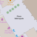 | |
| brand | user defined | Brand of the feature. |  | |
| bridge | yes / aqueduct / viaduct / cantilever / movable / covered / … | Eine Brücke ist ein Bauwerk zum Führen von Verkehrswegen oder baulichen Anlagen über natürliche oder künstlich angelegte Hindernisse. |  | |
| capacity | amount | Used for specifying capacity of a facility. |  | |
| charge | amount | Used for specifying how much is charged for use/access to a facility. See toll=* or fee=*.
|
 | |
| clothes | see key's page | Tagged on shops and other features to denote if they sell clothes or not and what type of clothes they sell. |  | |
| covered | yes | überdacht |  | |
| crossing | no / traffic_signals / uncontrolled / island / unmarked | Weiterführende Beschreibung für Knoten, die bereits mit highway=crossing oder railway=crossing bezeichnet sind.
|
 | |
| crossing:island | yes / no | Gibt an, ob ein Fußgängerübergang eine Mittelinsel besitzt |  | |
| cutting | yes / left / right | Ein meist künstlich angelegter Geländeeinschitt, um Wege, Straßen oder Schienen aufzunehmen. Für gewöhnlich in hügeligem Gelände zur Verringerung von Steigung bzw. Gefälle. |  | |
| disused | yes | Für navigatorisch wertvolle Gegenstände, die zur Zeit nicht mehr in Betrieb, stillgelegt oder verlassen sind. | 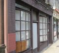 | |
| drinking_water | yes / no | Describes whether a drinking water is available |  | |
| drive_through | yes / no | Gibt an, ob eine Einrichtung einen Drive-through Service anbietet. Siehe auch drive_in=*
|
 | |
| drive_in | yes / no | Used to indicate if a cinema is a drive-in cinema or a restaurant offers drive-in service. drive_in=* is different than drive_through=*
|
 | |
| electrified | contact_line / rail | Zeigt Infrastruktur an, mit der Vehikel auf Schienen mit Elektrizität versorgt werden können. |  | |
| ele | Zahl | Höhe in Metern über Normal Null (bezogen auf WGS 84) | 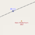 | |
| embankment | yes | Damm / Deich / Wall | 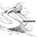 | |
| end_date | Datum | Datum an dem das Element abgerissen wurde. |  | |
| energy_class [en] | code | An energy class of the feature |  | |
| est_width | Zahl | grobe Schätzung der Breite |  | |
| fee | yes / no | Used for specifying whether fee is charged for use/access to a facility. See also toll=*.
|
 | |
| fire_object:type | poo / szo | Potentially dangerous and socially significant objects | ||
| fire_operator | Name | Fire station, which serves the object | ||
| fire_rank | 1bis / 2 to 5 | Rank fire, defined for a particular object | ||
| frequency | Number | Frequency in Hz |  | |
| gutter [en] | yes/no | Presence of the gutter |  | |
| hazard | see hazard | Indicates of the hazards. |  | |
| hot_water | yes / no | Describes whether a hot water is available | ||
| inscription | User Defined | Inschrift |  | |
| internet_access | yes / wired / wlan / terminal / no | Internetzugang |  | |
| layer | -5 bis 5 | Gibt die Höhenstaffelung verschiedener Wege oder einer Fläche an (0 = Grundhöhe, -1 = unter Grundhöhe, 1 = über Grundhöhe; Brücke in ebener Straße über Bach: layer=1). |  | |
| leaf_cycle | evergreen / deciduous / semi_evergreen / semi_deciduous / mixed | Beschreibt die Eigenschaft Blattwerk abzuwerfen |  | |
| leaf_type | broadleaved / needleleaved / mixed / leafless | Beschreibt die Art des Blattwerks |  | |
| location | underground / overground / underwater / roof / indoor | Die Lage |  | |
| narrow | yes | Zeigt an, dass sich ein Weg verengt. |  | |
| nudism | yes / obligatory / designated / no / customary / permissive | Gibt an, ob beim markierten Objekt FKK möglich, vorgeschrieben, gebräuchlich oder verboten ist. |  | |
| opening_hours | 24/7 or mo md hh:mm-hh:mm. (read described syntax) | Hier können die Öffnungszeiten eines Elements eingetragen werden. |  | |
| opening_hours:drive_through | 24/7 or mo md hh:mm-hh:mm. (read described syntax) | opening_hours describes when something is open for drive-through services. |  | |
| operator | Benutzer definiert | Betreiber, hier kann der Name der Firma oder Organisation, die dieses Element betreibt eingetragen werden. | ||
| power_supply | yes / no | Describes whether a power supply is available |  | |
| produce | User Defined | Describes a feature's agricultural output produced though a natural process of growing or breeding. |  | |
| rental | see key's page | Tagged on shops and other features to denote if they rent something or not and what they rent. |  | |
| sauna | yes / no | Describes whether a sauna is available |  | |
| service_times | siehe opening_hours | Zeiten der Gottesdienste |  | |
| shower | yes / no | Describes whether a shower is available |  | |
| sport | soccer / tennis / basketball / baseball / multi / ... | Describes which sports are placed on a facility such as a pitch or stadium. |  | |
| start_date | Datum | Eröffnungsdatum |  | |
| tactile_paving | yes /no | Kennzeichnet, ob eine Stelle durch einen Blindenstock ertastet oder verfolgt werden kann. |  | |
| tidal | yes | Zeigt an, dass sich dieser Bereich von den Gezeiten überflutet wird. |  | |
| toilets | yes / no | Describes whether a toilets is available |  | |
| topless | yes / no | Indicates if the described object provides the possibility of female topless practice |  | |
| tunnel | yes | Ein Tunnel ist eine künstliche Passage, die Berge, Gewässer oder andere Hindernisse (in der Regel als Verkehrsweg) unterquert. |  | |
| toilets:wheelchair | yes / no | Behindertentoilette |  | |
| wheelchair | yes / no / limited | Beschreibt ob eine Örtlichkeit rollstuhlgerecht ausgebaut ist. |  | |
| width | Zahl | Breite des Weges in Meter |  | |
Applies to landuse=forest and natural=wood detailing the sort of trees found within each landuse. Makes most sense when applied to areas. Be careful : this tag is now deprecated, please use instead leaf_cycle=*
|
 |
This table is a wiki template with a default description in English. Editable here.