Template:Language-Map Features
OpenStreetMap does not have any content restrictions on tags that can be assigned to Nodes, Ways or Areas. You can use any tags you like. However, there is benefit in agreeing a recommended set of features and corresponding tags in order to create, interpret and display a common basemap. This page contains a core recommended feature set and corresponding tags.
If you don't see an appropriate tag for what you would like to map see Proposed features or for grouping ways and nodes together into a higher level component, see Relations. From there you can see what features may be added (and maybe get them in sooner), or propose your own.
Notes on rendering:
- Using the tags here will mean that your editing efforts are more likely to show up in the various renderers. However, there is no guarantee that a tag listed here will be rendered by any particular renderer or by the renderers used by the OSM main map page.
- There also may be many tags that will render on the OSM main map page that are not listed here. This list is not updated with all the tags implemented by the renderers.
The tables are in grouped by theme, with the more commonly used first.
Physical
Highway
The highway tag is the primary tag used for highways. It is often the only tag. There are conventions for its use in particular countries. See Highway tag usage and Road pages for guidance.
| Key
|
Value
|
Element
|
Comment
|
Example
|
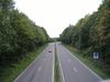
| highway |
motorway |
 |
A restricted access major divided highway, normally with 2 or more running lanes plus emergency hard shoulder. Equivalent to the Freeway, Autobahn etc.. |
File:Motorway-photo.jpg
|
| highway |
motorway_link |
|
The link roads (sliproads / ramps) leading to and from a motorway. Normally with the same motorway restrictions. .. |

|
| highway |
trunk |
|
Important roads that aren't motorways. Typically maintained by central, not local government. Need not necessarily be a divided highway. In the UK, all green signed A roads are, in OSM, classed as 'trunk'. |
|
| highway |
trunk_link |
|
The link roads (sliproads / ramps) leading to and from a trunk road. .. |

|
| highway |
primary |
|
Administrative classification in the UK, generally linking larger towns. |
|
| highway |
primary_link |
|
The link roads (sliproads / ramps) leading to and from a primary road. |
|
| highway |
secondary |
|
Administrative classification in the UK, generally linking smaller towns and villages |

|
| highway |
tertiary |
|
A "C" road in the UK. Generally for use on roads wider than 4 metres (13') in width, and for faster/wider minor roads that aren't A or B roads. In the UK, they tend to have dashed lines down the middle, whereas unclassified roads don't. |

|
| highway |
unclassified |
|
No administrative classification. Unclassified roads typically form the lowest form of the interconnecting grid network.
Note: This is not a marker for roads where we still need to choose a highway tag. |

|
| highway |
unsurfaced |
|
No administrative classification. Unsurfaced roads typically have the same status as an unclassified road. It is still part of the public highway (unlike a track) but has not got a metalled topping/surface. |
|
| highway |
track |
|
unpaved/unsealed roads for agricultural use; gravel roads in the forest etc. |

|
| highway |
residential |
|
roads accessing or around residential areas but which are not a classified or unclassified highway. |
|
| highway |
living_street |
|
a street where pedestrians have priority over cars, children can play on the street, maximum speed is low. |
|
| highway |
service |
|
generally for access to a building, motorway service station, beach, campsite, industrial estate, business park, etc. This is also commonly used for access to parking and trash collection. Sometimes called an alley, particularly in the US. |

|
| highway |
bridleway |
|
For horses, (in the UK, generally footpaths on which horses are also permitted) |

|
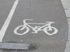
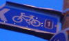
| highway |
cycleway |
|
For designated cycleways, i.e. mainly/exclusively for bicycles. If pedestrians are allowed as well, you can indicate this by adding a foot=yes tag. |
|
| highway |
footway |
|
For designated footpaths, i.e. mainly/exclusively for pedestrians. This includes walking tracks and gravel paths. If bicycles are allowed as well, you can indicate this by adding a bicycle=yes tag. |
|
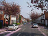
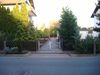
| highway |
pedestrian |
 |
For Roads , i.e. mainly/exclusively for pedestrians /Shopping Areas. Also for tagging squares and plazas, therefore add area=yes. |
File:Calle arenal.jpg
|
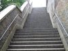
| highway |
steps |
|
For flights of steps on footways |
|
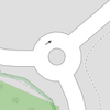
| highway |
mini_roundabout |
 |
Very small roundabouts only, larger ones should be junction=roundabout. In the UK, mini-roundabouts have a circular sign with a blue background, instead of the usual triangular sign
Rendered as anti-clockwise by default. To render clockwise add the tag direction=clockwise.
|
|
| highway |
stop |
|
A stop sign |
|
| highway |
traffic_signals |
|
Lights that control the traffic |

|
| highway |
crossing |
|
Pedestrians can cross a street here - e.g. zebra crossing |
|
| highway |
gate |
|
|
|
| highway |
stile |
|
Allow pedestrians to cross a wall or fence |

|
| highway |
cattle_grid |
|
Bars in the road surface that allow wheeled vehicles but not animals to cross. Sometimes known as a Texas Gate, even outside of Texas |
|
| highway |
toll_booth |
|
A road usage toll or fee is collected here |
|
| highway |
incline |
|
A slope or hill, may encounter slow moving trucks. Corresponding proposal Proposed_features/Incline was rejected! |
|
| highway |
incline_steep |
|
Just as incline, only steeper. Corresponding proposal Proposed_features/Incline was rejected! |
|
| highway |
viaduct |
|
A high and/or long bridge - more commonly carries water or trains (but see also waterway=aqueduct) |
|
| highway |
motorway_junction |
|
Indicates a junction (UK) or exit (US) ref should be set to the exit number or junction identifier. (Some roads - e.g. the A14 - also carry junction numbers, so the tag may be encountered elsewhere despite its name) |
|
| highway |
services |
|
A service station to get food and eat something, often found at motorways |
|
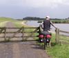
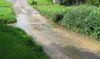
| highway |
ford |
|
The road crosses a stream or river, vehicles must enter the water node |
|
| highway |
bus_stop |
|
A small bus stop. Larger stations should be tagged as amenity=bus_station instead. |

|
| highway |
User Defined |
|
|
|
| junction |
roundabout |
|
This automatically implies oneway=yes, the oneway direction is defined by the sequential ordering of nodes within the Way. This applies on a way, tagged with highway=* already. |
|
| junction |
User Defined |
|
|
|
| highway |
construction |
|
For roads under construction, use with construction=* |
File:12Jan05 04.jpg
|
| construction |
User Defined |
|
Any linear highway object may be added, e.g. construction=motorway. Use with highway=construction
|
Cycleway
| Key
|
Value
|
Element
|
Comment
|
Example
|
| cycleway |
lane |
|
A lane is a route that lies within the roadway |
|
| cycleway |
track |
|
A track is a route that is separate from the road. |
File:BS Cellerstr.jpg
|
| cycleway |
opposite_lane |
|
lane in the opposite way (a "contraflow" lane) |
|
| cycleway |
opposite_track |
|
track in the opposite way (that is, separate from the road) |
|
| cycleway |
opposite |
|
just permitted to cycle in the opposite way (one way street except for cycles). Note - such streets are common in Belgium, the Netherlands and Denmark, for example, but are rare in the UK (although they do exist): often, instead, actually the street is two-way as normal for its whole length except for the very short section past the no-entry sign at the end, where cycles are excepted from the no-entry by means of a short lane separated by an island. This is called a "cycle plug". In some places this has been represented as very short oneway Way at the end with an adjacent cycleway, forming a little triangle with the road they join to. |
|
| cycleway |
User Defined |
|
|
|
Tracktype
| Key
|
Value
|
Element
|
Comment
|
Example
|
| tracktype |
grade1 |
|
paved track or heavily compacted hardcore. |
|
| tracktype |
grade2 |
|
unpaved track; surface of gravel or densely packed dirt/sand. |
|
| tracktype |
grade3 |
|
unpaved track; A mixture of hard materials and soft. Quite compact |
|
| tracktype |
grade4 |
|
unpaved track; tire marks, with plant growth in between. Mostly dirt, but some hard materials, or compressed materials mixed in. |
|
| tracktype |
grade5 |
|
unpaved track; subtle tire marks, lack of hardcore, Soft with low grip, subtle on the landscape. |
|
Waterway
| Key
|
Value
|
Element
|
Comment
|
Example
|
| waterway |
river |
|
For narrow rivers which will be rendered as a line. For larger rivers see Large Rivers (Other languages). |
|
| waterway |
canal |
|
An artificial open waterway used for transportation, waterpower, or irrigation.(Other languages). |
|
| waterway |
stream |
|
a naturally-forming waterway that is too thin to be classed as a river. Maybe you can just jump over it. |
|
| waterway |
drain |
|
An artificial waterway for carrying storm water or industrial discharge. |
|
| waterway |
dock |
|
An 'enclosed' area of water used for loading, unloading, building or repairing ships. |
|
| waterway |
lock_gate |
|
A thing to raise/lower the water level for vessels, often found in canals. |
|
| waterway |
turning_point |
|
A place to turn the driving direction for vessels, where the boats are longer than the river/canal is wide. |
|
| waterway |
aqueduct |
|
A bridge carrying a channel for supplying water (Other languages). |
|
| waterway |
boatyard |
|
Boat yard - a place for constructing, repairing and storing vessels out of the water. |
|
| waterway |
water_point |
|
A place to get fresh water e.g. for caravans. |
|
| waterway |
waste_disposal |
|
A place to release used water e.g. for caravans. |
|
| waterway |
mooring |
|
A place for anchoring vessels. |
|
| waterway |
weir |
|
A barrier built across a river, often to divert water for industrial purposes. Water can still flow over the top. |
|
| waterway |
dam |
|
A wall built across a river or stream to impound the water. A dam normally does not have water flowing over the top of it. |
|
| waterway |
User Defined |
|
|
|
Railway
See also landuse=railway.
Aeroway
Aerialway
Power
| Key
|
Value
|
Element
|
Comment
|
Example
|
| power |
tower |
|
For towers or pylons carrying high voltage electricty cables. Normally constructed from steel latticework. Should not be used for electricity or telephone cables carried on single wooden poles. |
|
| power |
line |
|
A way following the path of power cables. |
|
| power |
sub_station |
|
A tag for electric substations. |
|
Man Made
| Key
|
Value
|
Element
|
Comment
|
Example
|
| man_made |
works |
|
Industrial building to produce something |
|
| man_made |
beacon |
|
|
|
| man_made |
survey_point |
|
Triangulation pillars, geodetic vertices, and fixed equipment used by topographers (e.g. DGPS radio stations) |
|
| man_made |
power_wind |
|
Wind generated power, see also man_made=windmill |
|
| man_made |
power_hydro |
|
Power generated by water (from a river, lake, tide, ...) |
|
| man_made |
power_fossil |
|
Power generated by burning fossils (oil, gas, ...) |
|
| man_made |
power_nuclear |
|
Nuclear power plant |
|
| man_made |
tower |
|
A tall and often lean building or structure e.g. telecoms. Also see "Historic" below. |
|
| man_made |
water_tower |
|
A tower to store water in, usually found on hills beside or in a town |
|
| man_made |
gasometer |
|
http://en.wikipedia.org/wiki/Gasometer |

|
| man_made |
reservoir_covered |
|
|
|
| man_made |
lighthouse |
|
Sends out a light beam to guide ships |
|
| man_made |
windmill |
|
Windmill, mostly ancient and out of order, see also man_made=power_wind |

|
| man_made |
pier |
|
A "bridge into the ocean", usually for recreation |
|
| man_made |
pipeline |
|
A pipe for carrying various fluids, such as water, gas, sewage |
|
| man_made |
wastewater_plant |
|
Facilities used to treat wastewater (known as sewage in some countries) |
|
| man_made |
User Defined |
|
|
|
Leisure
Amenity
| Key
|
Value
|
Element
|
Comment
|
Example
|
| amenity |
pub |
|
A place selling beer and other alcoholic drinks; may also provide food or accommodation (UK) |
|
| amenity |
biergarten |
|
http://en.wikipedia.org/wiki/Biergarten |
|
| amenity |
nightclub |
|
a nightclub |
|
| amenity |
cafe |
|
a cafe |
|
| amenity |
restaurant |
|
Restaurant (not fast food) |
|
| amenity |
fast_food |
|
Fast Food Restaurant |
|
| amenity |
parking |
|
Car Park. Only nodes will get a parking symbol. Areas will be colored. Streets on car parking are often tagged highway=service |
 Concept example Concept example
|
| amenity |
bicycle_parking |
|
Parking for bicycles |
|
| amenity |
bicycle_rental |
|
Rent a bicycle (only big rental networks) |
|
| amenity |
car_rental |
|
Rent a car |
|
| amenity |
car_sharing |
|
Share a car |
|
| amenity |
taxi |
|
A place where taxis wait for passengers. |
|
| amenity |
fuel |
|
Petrol station; gas station; marine fuel; ... Streets to petrol stations are often tagged highway=service. |
|
| amenity |
telephone |
|
Public telephone |
|
| amenity |
toilets |
|
Public toilets (might require a fee) |
|
| amenity |
recycling |
|
recycling facilities (bottle banks etc.) |
|
| amenity |
public_building |
|
|
|
| amenity |
townhall |
|
A town hall building, regardless of whether it is currently used for administrative purposes |
|
| amenity |
place_of_worship |
|
A church, mosque, or temple, etc. Note that you also need religion=<whatever>, usually denomination=<whatever> and preferably name=<whatever> as well as amenity=place_of_worship. See the article for details. |
|
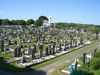
| amenity |
grave_yard |
|
A (smaller) place of burial, often you'll find a church nearby. Large places should be landuse=cemetery instead. |
|
| amenity |
post_office |
|
|
|
| amenity |
post_box |
|
Alternative mail-carriers can be tagged via "operator="; |
|
| amenity |
school |
|
school and grounds |
|
| amenity |
university |
|
a University campus or buildings |
|
| amenity |
college |
|
a College campus or buildings |
|
| amenity |
pharmacy |
|
Pharmacy
dispensing=yes
dispensing=no or omitted |
|
| amenity |
hospital |
|
|
|
| amenity |
library |
|
A public library (municipal, university, ...) to borrow books from. |

|
| amenity |
police |
|
A Police station |
|
| amenity |
fire_station |
|
A Fire station |
|
| amenity |
bus_station |
|
Bus Station (this is a big station, a bus stop is highway=bus_stop) |
|
| amenity |
theatre |
|
a theatre or opera house |
|
| amenity |
cinema |
|
a cinema |
|
| amenity |
arts_centre |
|
an arts centre |
|
| amenity |
courthouse |
|
a place where justice is dispensed |
|
| amenity |
prison |
|
a prison |
|
| amenity |
bank |
|
a bank (for a bank that also has an ATM, use amenity=bank;atm) |
|
| amenity |
bureau_de_change |
|
Bureau de change, Currency exchange, Wechsel, Cambio - a place to change foreign bank notes and travellors cheques |
|
| amenity |
atm |
|
an ATM or cash point |
|
| amenity |
fountain |
|
A fountain for cultural / decorational / recreational purposes. |
|
| amenity |
User Defined |
|
|
|
Shop
| Key
|
Value
|
Element
|
Comment
|
Example
|
| shop |
User Defined |
|
Feel free to use/invent values suitable for your country, a small global set is also being developed for ease of rendering and searching |
|
| shop |
supermarket |
|
Supermarket |

|
| shop |
convenience |
|
Convenience Store - a small local store usually selling a small selection of food items plus things like simple first aid, household, stationary and car items |
|
| shop |
butcher |
|
Selling meat |
|
| shop |
bicycle |
|
A shop that sells bicycles, bicycle equipment and may rent or repair them
|
| shop |
doityourself |
|
A shop that sells tools and supplies to do-it-yourself householders, gardening, ...
|
| shop |
dry_cleaning |
|
A shop or kiosk offering a clothes dry cleaning service. The actual cleaning may be done elsewhere. |
|
| shop |
outdoor |
|
A shop that sells camping, walking, climbing, fishing and other outdoor sports equipment (and GPSes) |
|
| shop |
kiosk |
|
A small shop on the pavement that sells magazines, tobacco, newspapers, sweets and stamps. |
|
Tourism
Historic
See also railway=preserved for historic trains.
Landuse
| Key
|
Value
|
Element
|
Comment
|
Example
|
| landuse |
farm |
|
Animals, vegetables, flowers, fruit growing (Other languages) |

|
| landuse |
quarry |
|
Surface mineral extraction (Other languages) |
|
| landuse |
landfill |
|
Place where waste is dumped upon. Other languages |
|
| landuse |
basin |
|
Other languages |

|
| landuse |
reservoir |
|
Stores water, may covered or uncovered (Other languages) |

|
| landuse |
forest |
|
Managed forest or woodland plantation (Other languages). See also natural=wood |

|
| landuse |
allotments |
|
A piece of land given over to local residents for growing vegetables and flowers (UK). "Kleingärten" (DE) |

|
| landuse |
residential |
|
Predominantly houses or apartment buildings |
|
| landuse |
retail |
|
Predominantly shops |

|
| landuse |
commercial |
|
Predominantly offices |

|
| landuse |
industrial |
|
Predominantly workshops, factories or warehouses |

|
| landuse |
brownfield |
|
Describes land scheduled for new development where old buildings have been demolished and cleared |
File:Landuse-brownfield.png
|
| landuse |
greenfield |
|
Describes land scheduled for new development where there have been no buildings before |
|
| landuse |
railway |
|
Area for railway use, generally off-limits to the general public |
|
| landuse |
construction |
|
"Under construction" site, should become something different once the construction is finished |
|
| landuse |
military |
|
For land areas owned/used by the military for whatever purpose |
|
| landuse |
cemetery |
|
Place for burials. Smaller places (e.g. with a church nearby) may use amenity=grave_yard instead. |
|
| landuse |
village_green |
|
An area of common land, usually grass, in the centre of a village (quintessentially English - defined separately from 'common land' under the Commons Registration ACt 1965 and the Commons Act 2006) |

|
| landuse |
recreation_ground |
|
An open green space for general recreation, which may include pitches, nets and so on, usually municipal but possibly also private to colleges or companies |

|
| landuse |
User Defined |
|
|
|
Military
See also landuse=military.
| Key
|
Value
|
Element
|
Comment
|
Example
|
| military |
airfield |
|
A place where military planes take off and land |
|
| military |
bunker |
|
Buildings, often build from concrete, to stand even heavier fire. |
|
| military |
barracks |
|
Buildings where soldiers live and work. |
|
| military |
danger_area |
|
Usually a large marked area around something like a firing range, bombing range, etc which is an exclusion zone. |
|
| military |
range |
|
Where soldiers have practice with their weapons (firing, bombing, artillery, ...). |
|
| military |
User Defined |
|
|
|
Natural
| Key
|
Value
|
Element
|
Comment
|
Example
|
| natural |
spring |
|
A place where ground water flows naturally from the ground ((hydrology, land) (3596) Other languages) |
|
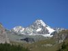
| natural |
peak |
|
top of a hill or mountain |
|
| natural |
glacier |
|
Areas (or peaks) covered with ice throughout the year |

|
| natural |
volcano |
|
A volcano, either dormant, extinct or active |
|
| natural |
cliff |
|
Rock face |
|
| natural |
scree |
|
Loose rock |
|
| natural |
scrub |
|
Uncultivated land covered with bushes or stunted trees |
|
| natural |
fell |
|
Bare upper lying uncultivated land principally covered with grass and often grazed. |
|
| natural |
heath |
|
Bare lower lying uncultivated land with bushes but little or no tree cover. |
|
| natural |
wood |
|
Natural woodland (trees). See also landuse=forest |
|
| natural |
marsh |
|
waterlogged area |
|
| natural |
water |
|
Lakes, etc. Always keep water on the right side of the way and land on the left side, in relation to the sequence of nodes in the Way for it to show correctly on rendered maps. |
|
| natural |
coastline |
|
The coastline should run clockwise around water and anti-clockwise around land, i.e. land on the left side and water on the right side of the way (that is, according to the sequence of nodes in the way), for it to show correctly. |
|
| natural |
mud |
|
(Other languages) |
|
| natural |
beach |
|
Beach: sand, gravel or pebble (Other languages) |

|
| natural |
bay |
|
Bay (Other languages) |
|
| natural |
land |
|
Land that exists within another area, such as a lake. (i.e an island). Keep water on the right and land on the left side in relation to sequence of nodes in the Way. Layering may also be required |
|
| natural |
User Defined |
|
|
|
Non Physical
Route
Boundary
| Key
|
Value
|
Element
|
Comment
|
Example
|
| boundary |
administrative |
|
e.g. State, county, local council (unclear how these are specified. Clarify!). Use therefore border_type= |
|
| boundary |
civil |
|
|
|
| boundary |
political |
|
Electoral boundaries |
|
| boundary |
national_park |
|
Area of outstanding natural beauty, set aside for conservation and for recreation (Other languages) |
|
Sport
| Key
|
Value
|
Element
|
Comment
|
Example
|
| sport |
10pin |
|
10-pin Bowling |
|
| sport |
athletics |
|
|
|
| sport |
baseball |
|
|
|
| sport |
basketball |
|
|
|
| sport |
bowls |
|
Lawn bowls |
|
| sport |
climbing |
|
Rock climbing - natural or articial climbs (climbing walls) |
|
| sport |
cricket |
|
|
|
| sport |
cricket_nets |
|
Cricket nets for practise |
|
| sport |
croquet |
|
|
|
| sport |
cycling |
|
|
|
| sport |
dog_racing |
|
|
|
| sport |
equestrian |
|
|
|
| sport |
football |
|
(Clarification is needed here; does this refer to the game known as "soccer" in North America, or to something like American/Canadian football? Given that sport=soccer is also listed, I'm inclined towards the latter interpretation... Dshpak 23:10, 4 August 2007 (BST)). A less ambiguous way would be to use the true (internationally recognised) names for these sports, i.e. Association Football, Rugby Union Football, American Football, Rugby League Football, Australian Rules Football, etc. |
|
| sport |
golf |
|
|

|
| sport |
gymnastics |
|
|
|
| sport |
hockey |
|
|
|
| sport |
horse_racing |
|
|
|
| sport |
motor |
|
|
|
| sport |
multi |
|
|
|
| sport |
pelota |
|
|
|
| sport |
racquet |
|
|
|
| sport |
rugby |
|
|
|
| sport |
skating |
|
|
|
| sport |
skateboard |
|
|
|
| sport |
soccer |
|
|
File:Sport-soccer.png
|
| sport |
swimming |
|
|

|
| sport |
skiing |
|
|
|
| sport |
table_tennis |
|
|
|
| sport |
tennis |
|
Tennis courts |
File:Sport-tennis.png
|
Abutters
| Key
|
Value
|
Element
|
Comment
|
Example
|
| abutters |
residential |
|
predominantly houses and apartments |
|
| abutters |
retail |
|
predominantly shops |
|
| abutters |
industrial |
|
predominantly workshops, factories, warehouses |
|
| abutters |
commercial |
|
office buildings, business parks, etc. |
|
| abutters |
mixed |
|
where there is no clear predominance, for example mixed shops and residences in an inner city ring |
|
Accessories
| Key
|
Value
|
Element
|
Comment
|
Example
|
| fenced |
yes/no |
|
|
|
| lit |
yes/no |
|
Street lighting --- this tag is listed on Deprecated_features but there is no alternative proposed |
|
Properties
| Key
|
Value
|
Element
|
Comment
|
Example
|
| area |
yes |
|
Making a closed way render solid |
|
| bridge |
yes |
|
A bridge, use together with the layer tag. |
Concept example
|
| tunnel |
yes |
|
A tunnel, use together with the layer tag. |
Concept example
|
| mountain_pass |
yes |
|
The highest point of a mountain pass. |
|
| cutting |
yes |
|
A cut in the land to carry a road or tram. Mostly in hilly landscape. Source |
Picture
|
| embankment |
yes |
|
A raised bank to carry a road, railway, or canal across a low-lying or wet area. Source |
|
| lanes |
Num |
|
Number of travel lanes in each (or only permitted) direction |
|
| layer |
-5 to 5 |
|
This numerical tag used to be `elevation', however it got renamed due to confusion with the ele and altitude tags used by tracklog imports. |
layer:-1
layer:1 (not +1)
|
| surface |
paved/unpaved |
|
|
|
| ele |
Num |
|
Altitude (meter over sea level) |
|
| width |
Num |
|
Width of way in metres |
|
| est_width |
Num |
|
A rough guess of the width of way in metres |
|
| depth |
Num |
|
Depth in metres |
|
| est_depth |
Num |
|
A rough guess of the Depth in metres |
|
| start_date |
Date |
|
Date feature was created |
|
| end_date |
Date |
|
Date feature was removed |
|
| operator |
User Defined |
|
The operator tag can be used to name a company or corporation who's responsible for a certain object or who operates it |
"A Company"
|
Restrictions
| Key
|
Value
|
Element
|
Comment
|
Example
|
| access |
yes/private/ permissive/ unknown/no |
|
General access permission. 'permissive' means there is no legally-enshrined right of access, but the landowner has allowed it at his/her discretion. 'private' means access is restricted to the landowner. |
|
| bicycle |
yes/private/ permissive/ unknown/no |
|
Access permission for bicycles. For values see above |
|
| foot |
yes/private/ permissive/ unknown/no |
|
Access permission for pedestrians. For values see above |
|
| goods |
yes/private/ permissive/ unknown/no |
|
Access permission for light commercial vehicles (LCV) or goods vehicles of category N1 with a maximum allowed mass of up to 3.5 tonnes. For values see above |
|
| hgv |
yes/private/ permissive/ unknown/no |
|
Access permission for Heavy Goods Vehicles (HGV) (UK), e.g. for goods vehicles of category N2 and N3 (trucks, lorries) with a maximum allowed mass over 3.5 tonnes. For values see above |
|
| horse |
yes/private/ permissive/ unknown/no |
|
Access permission for horse riders. For values see above |
|
| motorcycle |
yes/private/ permissive/ unknown/no |
|
Access permission for motorcycles. For values see above |
|
| motorcar |
yes/private/ permissive/ unknown/no |
|
Access permission for (motor) cars. For values see above |
|
| psv |
yes/private/ permissive/ unknown/no |
|
Access permission for Public Service Vehicles (UK), e.g. buses and coaches. See above |
|
| motorboat |
yes/private/ permissive/ unknown/no |
|
|
|
| boat |
yes/private/ permissive/ unknown/no |
|
|
|
| oneway |
yes (or true/1)/
-1/
no (or false) |
|
The permitted direction for a way is indicated by sequential order of nodes within the way (enable arrows in JOSM!). -1 for oneway direction opposite to the sequence of nodes. |
Concept example
|
| noexit |
yes |
|
A dead end road/cul de sac with only one access road |
|
| date_on |
Date |
|
Date restriction starts |
|
| date_off |
Date |
|
Date restriction stops |
|
| day_on |
Day of Week |
|
Day restriction starts |
|
| day_off |
Day of Week |
|
Day restriction stops |
|
| hour_on |
Time |
|
Time restriction starts |
|
| hour_off |
Time |
|
Time restriction stops |
|
| maxweight |
Num |
|
Weight limit in tonnes |
|
| maxheight |
Num |
|
height limit in metres |
|
| maxwidth |
Num |
|
width limit in metres |
|
| maxlength |
Num |
|
length limit in metres |
|
| maxspeed |
Num |
|
Maximum speed in km/h |
|
| minspeed |
Num |
|
Minimum speed in km/h |
|
| toll |
yes |
|
Toll or fee must be paid to access way, see also highway=toll_booth |
|
Naming
Name
References
| Key
|
Value
|
Element
|
Comment
|
Example
|
| ref |
User Defined |
|
The common default reference (eg M25) |
|
| int_ref |
User Defined |
|
International reference (eg E30) |
|
| nat_ref |
User Defined |
|
National reference |
|
| reg_ref |
User Defined |
|
Regional reference |
|
| loc_ref |
User Defined |
|
Local reference |
|
| old_ref |
User Defined |
|
Historical reference |
|
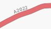
| ncn_ref |
User Defined |
|
The number reference (eg 54) of a National Cycle Network route. In the UK, national routes have single-or double-digit numbers with a red background on the signs. |
|
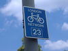
| rcn_ref |
User Defined |
|
The number of the regional cycle network. In the UK the regional routes have double-digit numbers with a blue background on the signs. |
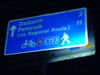
(Sign showing both national and regional spur).
|
| lcn_ref |
User Defined |
|
The number of the local cycle network |
|
| source ref |
User Defined |
|
To record the URI, source reference (eg Landsat) or other link to physical sources. |
|
| icao |
User Defined |
|
ICAO International airport codes |
|
| iata |
User Defined |
|
IATA International airport codes |
|
Places
| Key
|
Value
|
Element
|
Comment
|
Example
|
| place |
continent |
|
One of the continents: Asia, Africa, North America, South America, Antarctica, Europe, Australia
(from largest in size to smallest) |

|
| place |
country |
|
country (on areas and ways, border_type=nation is used instead) |

|
| place |
state |
|
state |
|
| place |
region |
|
region |
|
| place |
county |
|
county |
|
| place |
city |
|
As defined by national/state/provincial government. Often over 100,000 people |
|
| place |
town |
|
As defined by national/state/provincial government. Generally smaller than a city, between 10,000 and 100,000 people |
|
| place |
village |
|
As defined by national/state/provincial government. Generally smaller than a town, below 10,000 people |
|
| place |
hamlet |
|
As defined by national/state/provincial government. Generally smaller than a village, just a few houses |
|
| place |
suburb |
|
Named area of town or city. Often a suburb is its own municipality, with separate government, and should be tagged as such. |
|
| place |
locality |
|
An unpopulated, named place. |
|
| place |
island |
|
identifies an island (see also natural=land) |
|
See OSM_tags_for_routing for the guideline to automatic interpretation of this tag.
See also the FAQ for a description how to use areas and nodes when tagging a place.
Annotation
some keys are allowed with one of the following values.
| Key
|
Value
|
Element
|
Comment
|
Example
|
| note |
User defined |
|
A note to yourself or to other mappers. There is a map where you can view notes |
|
| description |
User defined |
|
Text that might be viewable to the end user (perhaps using a search system or a map with pop-ups). |
|
| image |
URI |
|
Reference to an image (use the "source_ref" key below when the image is referencing the source of the element) |
|
| source |
extrapolation |
|
Extension of information from a known source |
|
| source |
knowledge |
|
Local or common knowledge |
|
| source |
historical |
|
from out-of-copyright mapping or other historical document |
|
| source |
image |
|
photograph or video |
|
| source |
survey |
|
gpx track or other physical survey |
|
| source |
voice |
|
Voice recordings, eg dictaphone |
|
| source |
User defined |
|
|
|
| source_ref |
User defined |
|
To record the URI, source reference (eg Landsat) or other link to physical sources. |
|
Editor keys
These keys are set by the editor (usually JOSM or Potlatch) and are not intended to be changed manually.
| Key
|
Value
|
Element
|
Comment
|
Example
|
| created_by |
defined by editor |
|
Identifies the editing software which carried out this edit. |
|
| history |
defined by editor |
|
Used to identify a way that has been recovered from an earlier version. |
|


 Concept example


