Cs:Horská kola
Warning: Default sort key "Horska kola" overrides earlier default sort key "Horská kola".

|
| Popis |
| Trasy pro horská kola |
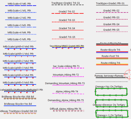
| Značky |
O této stránce
Tato stránka si klade za cíl pomoci s tvorbou OSM map s údaji pro bikery - cyklisty na horských kolech. Vznikla postupným překladem anglické verze, která původně byla překladem z německé stránky, která odstartovala toto téma.
Všeobecné klíče pro cesty, které jsou použitelné pro horskou cyklistiku, ale ne přímo pro ni určené
| klíč | poznámka |
|---|---|
highway=path/track
|
Pokud je cesta tagována highway=footway a jízda na kole je povolena, zvažte změnu na highway=path + foot=designated + bicycle=yes/designated |
foot=yes/no/designated/private/permissive/destination/unknown
|
- |
bicycle=yes/no/designated/private/permissive/destination/dismount/unknown
|
Je jízda na kole (z právního hlediska) povolena? |
width=<šířka v metrech>
|
Šířka cesty |
surface=ground/sand/stone/gravel/grass/dirt
|
Materiál povrchu stezky nebo cesty |
smoothness=excellent to impassable
|
Klasifikace fyzické použitelnosti cesty pro dopravní prostředky opatřené koly |
tracktype=grade1 to grade5
|
Klasifikace pevnosti povrchu cesty, obvykle používaná u highway=track
|
trail_visibility=excellent/good/intermediate/bad/horrible/no
|
Klasifikace viditelnosti stezky (nikoliv celé turistické trasy) a orientaci na ní |
Základní klíče související s horskou cyklistikou
| klíč | hodnota | návrh/odkaz na prvek mapy | Stav/vývoj |
|---|---|---|---|
mtb:scale=0-6
|
Označení obtížnosti sjízdnosti stezky na horském kole. Použijte pro sjezdy, pěšinky, ale i pro cesty které nejsou singletraily. Stupnice je založena na německém měřítku "Singletrailskala". | key:mtb:scale | Schváleno |
mtb:scale:imba=0-4
|
Stupnice obtížnosti pro budované trasy. Použití hlavně v Severní Americe. | key:mtb:scale:imba | Schváleno |
mtb:scale:uphill=0-5
|
Stupnice obtížnosti pro stoupání. Použijte pokud má stezka výrazný sklon. | key:mtb:scale:uphill | Schváleno |
incline=<stoupání v %> nebo up/down
|
Jak příkrá je stezka. Použijte prosím tento tag ve spojení s mtb:scale:uphill pro specifikaci směru cesty (stoupání vs sjezd). | Key:incline | Schváleno |
mtb:type=crosscountry/allmountain/downhill/trial/freeride
|
Přidání dalších atributů stezky z pohledu MTB použití. | Proposed_features/mtb:type | Viz obvykle používané hodnoty taginfo |
mtb:description=jakýkoliv
|
Popis a další informace o stezce z pohledu MTB použití. | Proposed_features/mtb:description | Schváleno |
mtb:access=diskutováno
|
Informace o dnech a hodinách, kdy je trail otevřen pro MTB použití, o dočasném uzavření,... | Proposed_features/mtb_access | Neaktivní, neschválený návrh |
mtb:name=any
|
Traily někdy mají jména, která jsou používána pouze bikery a nejsou oficiální. Jde o jiný klíč než Key:loc_name | ||
class:bicycle:mtb=-3 až 3
|
Subjektivně specifikuje jak je trail vhodný / zábavný pro běžnou MTB jízdu. Možno použít jen na úseky cesty. | Class:bicycle | Klíč je dle taginfo používán, ale je zpochybňována jeho ověřitelnost |
class:bicycle:mtb:technical=-3 až 3
|
Subjektivně specifikuje, jak je trail vhodný / zábavný pro technické MTB - enduro/freeride/trial jezdce (mtb:scale=2 a výše) | Class:bicycle | Klíč je dle taginfo používán, ale je zpochybňována jeho ověřitelnost |
aerialway:bicycle=yes/summer/no
|
Specifikuje, zda lanovka nebo lyžařský vlek poskytuje přepravu kol. Použijte hodnotu summer, pokud je přeprava kol poskytována jen v letní sezóně. U kabinových, kabinkových a smíšených lanovek je defaultní hodnotou "yes", u sedačkových lanovek a vleků "no" | Proposed_features/Piste_Maps |
Související návrhy, které mohou doprovázet popis MTB stezek
| klíč | poznámka | návrh | stav/vývoj |
|---|---|---|---|
tourism=informationinformation=map
|
Informační bod s mapou trailů, typicky se vyskytuje na začátku trailů. | Proposed_features/information | |
tourism=informationinformation=guidepost
|
Informační bod s ukazateli směru (rozcestník). | Proposed_features/Guidepost | |
osmc:symbol=*
|
strojově čitelný popis značky trasy |
Výše uvedené klíče jsou používány, ale sledujte prosím případné změny. Jsou zde uvedeny pro upozornění na detaily, kterých je vhodné si při průzkumu povšimnout. Prozatimní schéma tagování nám umožňuje je zaznamenat.
Další klíče (tagy) když je cesta součástí MTB stezky / Relace
Poznámka: pro MTB stezky není definován specifický network=*. Pro lepší klasifikaci cest použijte místo toho tagy distance/ascent/descent/roundtrip, jak je uvedeno v následující tabulce:
| klíč | comment |
|---|---|
route=mtb
|
konzistentní značení s turistickými a cykloturistickými trasami. |
ref=R811,...
|
referenční identifikátor trasy, pokud existuje. |
name=Alpentour Austria,...
|
jméno trasy. |
distance=délka v km |
Délka trasy, je-li známa. Poskytuje informaci uživatelům, ale také automatizovaným kontrolním nástrojům, které pomocí ní mohou určit úplnost zaznačení trasy. Není-li zadána jednotka, předpokládají se km (jinak lze použít např. 25miles) |
ascent=nastoupané metry |
Nastoupané metry trasy (lze explicitně zadat jiné jednotky, např. 300feet). Má-li trasa začátek a konec trasy v jiné nadmořské výšce, použijte také tag descent. |
descent=naklesané metry |
Naklesané metry trasy (lze explicitně zadat jiné jednotky, např. 300feet). Používejte pouze pokud je začátek trasy odlišný od jejího konce a není ve stejné výšce. |
roundtrip=yes/no |
Nastavte roundtrip=no, pokud trasa vede z A do B a netvoří okruh (okruh se značí jako roundtrip=yes). |
Můžete si vytvářet vlastní mapy využívající route=mtb pro Garmin/MapSource nebo Qlandkarte GT - stačí následovat proceduru popsanou zde: OSM_Map_On_Garmin/mtb_map(en).
Jak správně nastavovat klíče (tagy) pro mtbiking
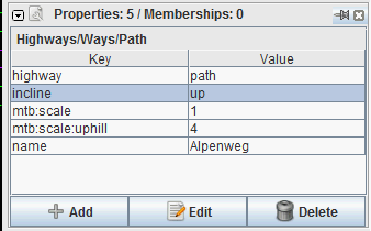
JOSM nyní obsahuje klíče mtb:scale v předvolbách pro stezky (paths) a cesty (tracks). Ostatní klíče jako incline, mtb:scale:uphill; mtb:description; mtb:scale:imba a další, můžete přidat ručně v panelu vlastností objektu tlačítkem přidat (add), případně si do JOSM nahrát předvolby specifické pro MTB (http://josm.openstreetmap.de/wiki/Presets(en), dostupné přes menu Nastavení JOSM).
Příklad JOSM:
V Potlatchu vyberte cestu a klikněte na ikonu "+":
Poté nahraďte key skutečným klíčem a zadejte hodnotu do šedého pole type value here.
Renderování MTB map
- VTTrack zobrazuje různé MTB vlastnosti na různých mapových podkladech (OpenStreetMap, GoogleMaps, French Geoportail maps). Také zahrnuje jiné zdroje tras vyjížděk a MTB stezek, zvláště ty, jejichž klasifikace je přenositelná na mtb:scale (VTTour.fr, Singletrack.fr, Gulliver.it, cycloalpinismo.com).
- Na openrouteservice.org si můžete naplánovat trasu z bodu A do bodu B s preferencemi pro mtb stezky a trasy.
- Rendering of both MTB features together with specific hiking trail markings (red/green/blue/yellow) in Czechia and bordering regions of surrounding countries (Germany, Austria, Poland, Slovakia) are available on Mtbmap.cz. The map also supports drawing of your planned trips with generation of altitude profiles.
Rendering of MTB maps on Garmin units
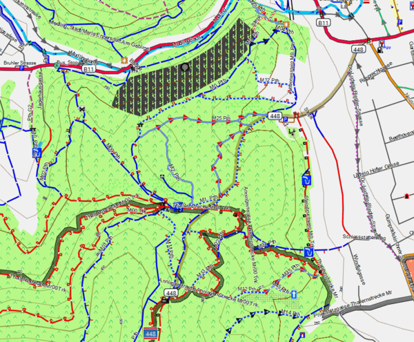
You can download routable mountainbike maps for European countries, Alps, Australia/NewZealand, South America and Africa on Openmtbmap.org The maps support autorouting with preference for mtb trails and cycleways, and give visual display of mtb:scale; mtb:scale:uphill (taking incline into account for "downhill arrows") and route=mtb.
You can create your own maps using mkgmap and the style-file of openmtbmap.org.


See also
- Portal for listing mountainbiketours on OSM: Mountainbiketours
- Portal for Cycling: Bicykly
- Hiking
- Climbing and Hiking (English): Approved features/Hiking
- Highway=path Examples: Tag:highway=path/Examples
Mapy
- Renderování Turistických a cyklistických map: HikingBikingMaps
- Renderování MTB Specifických Garmin map: Mtb_map OSM Map On Garmin/mtb map nebo openmtbmap.org
- Orienteering Map Specifications, including MTB-O
- MTB trails with altitude profiles, routing capabilities and GPX export: www.xctrails.org
- Kombinovaná MTB a turistická mapa České republiky a příhraničních oblastí sousedních zemí: mtbmap.cz
- VTTrack (je třeba si zapnout vrstvu "Sentier OSM")
Německy
- Typy cyklostezek: De:Bicycle/overview ways(de)
- Turistické trasy: de:hiking(de), WikiProject_Germany/Wanderwege-Netz(de)
- Cesty pro horská kola: Mountainbiketouren(de)
- Viz také: WikiProject_Austria/Howto_Map_Skitours(de)


