Key:crossing
 |
| Description |
|---|
Further refinement for nodes already tagged with highway=crossing or railway=crossing |
| Group: crossings |
| Used on these elements |
| Documented values: 9 |
| Requires |
| Useful combination |
| Status: approved |
| Tools for this tag |
|
This tag is used for more accurately describing specific types of pedestrian crossings across roads and other types of crossing over road or rail. Crossing infrastructure for the convenience of pedestrians, cyclists etc. should first be tagged with highway=crossing or railway=crossing as appropriate. The specific type of crossing may be further specified with the crossing=* tag and other properties described below.
The tag is set for the node where both ways are crossing (footway and street, street and railway and so on). For detailed mapping it may be useful to additionally tag ways leading from a sidewalk to the crossing node with footway=crossing or cycleway=crossing as appropriate.
Values
(Note: In American English, a "crosswalk" is either a marked crossing or a signalized crossing, but not an unmarked, unsignalled crossing.)
Approved

crossing=traffic_signals- A crossing with traffic signals. (May or may not feature road markings.) Mostly near
highway=traffic_signals. crossing=uncontrolled- A generic crossing with no traffic signals of any type, just road markings; e.g., zebra-crossings. The markings can be described with
crossing:markings=*. Mostly in combination withhighway=crossing. crossing=unmarked- A crossing without road markings or traffic signals.
crossing=no- Where definitely no crossing is possible/legal. Used at places where one would expect a crossing, but where there isn't one. As
crossing=noexcludes the existence of a crossing, it must be used withouthighway=crossing. It is also used onhighway=traffic_signalsnodes where pedestrian crossings are separately mapped.
Other used
crossing=marked- Any marked crossing which has no traffic lights. Duplicate of
crossing=uncontrolledand in case of zebra markingscrossing=zebra, i.e. a crossing with road markings, but no traffic lights. The markings can be described withcrossing:markings=*. crossing=zebra- A crossing marked with a striped pattern, but no traffic signals. In some countries, it gives priority to crossing pedestrians over vehicle traffic. Note that in some countries (e.g. in Italy, Spain, Switzerland, or United States), crossings with traffic lights are also marked with a striped pattern. However, tagging should give precedence to the traffic lights.
- This tag was initially documented as England only, but with the temporary adoption by iD editor has gained worldwide usage.
crossing=*+crossing_ref=zebrais a more popular alternative to indicate that a crossing is marked with a striped pattern independent of the presence of traffic signals.crossing=island- Use
crossing:island=yesin preference; in addition tocrossing=traffic_signals/uncontrolled/unmarked. - A crossing with a small traffic island for pedestrians in the middle of the road. Because this tag is orthogonal to traffic_signals/uncontrolled/unmarked classification, tagging
highway=crossingwithcrossing=islandmakes it impossible to distinguish betweencrossing=traffic_signalsandcrossing=uncontrolled. For this reason, many editors do not use this tag, and some consider it as a broken tagging scheme.[1] - Note: If a path on a traffic island is mapped separately from the crossings, use
footway=traffic_islandwithhighway=footwayinstead. - Some mappers add
crossing=islandto thehighway=footway+footway=crossingway on the traffic island. crossing=informal- (use without
highway=crossing) For places where it is highly likely that the pedestrian will want to cross the road exactly there, but there are no markings nor signals, nor was a crossing intended to be there by the municipality.
Additional tags
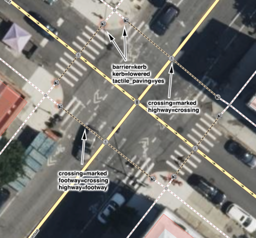
Accessibility
kerb=yes/no/raised/regular/rolled/lowered/flush/...- Used to indicate the height or type and thus accessibility of a kerb. On crossing ways, it is preferred to use
barrier=kerb+kerb=*on a node as part of the crossing
  way. Alternatively, on the crossing node,
 kerb:left=*andkerb:right=*can be used. - For routing, it is important that
barrier=kerb+kerb=*should not be on the crossing node that intersects with the road. In addition to that, the kerb node should not be connected to the sidewalk
  way as that can prevent accessibility routing along the adjacent sidewalk.
 tactile_paving=yes/(no)/incorrect- To indicate whether there is a pattern in the ground to aid the blind. Can be used on a node in conjunction with
kerb=*.
Designation
crossing_ref=*- The traditional, region-specific reference, such as
zebra,toucanorpelican. This originated in the UK, but has since evolved in other countries as well. The
meaning is sometimes questioned as semantically unclear in other countries.
Mode of transport
bicycle=*- A value of
yesmeans that pedal cyclists are permitted to ride across the crossing. horse=*- A value of
yesmeans that horse riders are permitted to ride across the crossing. segregated=yes/no- A value of
yesindicates that crossing traffic of differing types is segregated from each other (that is, there is a separate crossing area for each mode of transport). At many traffic lights, crossing foot and bicycle traffic are segregated. A more regional example is the segregation of horse and foot traffic within some UK Pegasus crossings. - Like many others, this parameter is
 boolean, i.e. it can take the values
 yesorno. Different from several other Boolean parameters, in this case no default is assumed.
Support
Crossing nodes are shared by both the road and the crossing way. A no value for an access tag like bicycle=* or horse=* on a highway=crossing node is meant to apply only to traffic on the crossing, not on the main road: (highway=crossing + bicycle=no) means that cyclists must dismount before crossing the road; it does not mean that cyclists on road must do this.
Nevertheless, most routers do not support this, which may lead to potentially undesired effects like blocking routing along the road for cyclists.
You may ask router authors to add support for this tagging. In most cases it is also possible to use more detailed tagging and split the crossing way into parts and add bicycle=no on applicable parts.
Traffic signals
crossing:signals=yes/no(proposed)- Indicates whether the crossing is controlled by a traffic signal, such as a pedestrian signal, regardless of whether it is marked by road pavement markings.
button_operated=yes/no- Crossing light and/or sound on a traffic signal can be requested by a bicycle rider or pedestrian via button press.
traffic_signals:sound=yes/no- Pedestrian traffic with sound for the visually impaired.
traffic_signals:vibration=yes/no- Pedestrian traffic signals with vibration for the visually impaired.
Other features
crossing:island=yes/no- Indicates whether the crossing has a refuge island.
supervised=yes/no- A value of
yesindicates that the crossing may be managed by a Crossing guard at busy times. The default is
 no. flashing_lights=yes/no/always/button/sensor- A value of
yesindicates that flashing lights warn drivers when a pedestrian is crossing. The default isno. For more detail, consider using a value ofbutton,sensor(if the lights turn on automatically), oralways(if the lights are constantly flashing). crossing:continuous=yes/no- Indicates whether a path continues uninterrupted across a road.
crossing:markings=*- Describes the markings on the road.
crossing:signed=*wether or not a traffic sign (typically with the 'crossing pedestrian'-icon in a triangle) is at the crossing
Examples
The following table shows how the crossing might be tagged:
| Description (and local name) | Tags | Image |
|---|---|---|
|
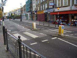
A crossing for pedestrians only and no traffic lights (but may have a flashing amber globes on poles in some regions such as in the United Kingdom) The crossing often has distinctive white stripes on the road. It may have additional protections, such as reduction of lanes, or other speed limitation signals and enforcement devices on the ground. If the street is large enough, the crossing may also be protected by traffic separation islands (see below).
|
|
|
|
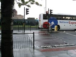
A crossing for pedestrians only with traffic lights (button operated or not). This is the most common type of crossings in dense urban areas of cities (at least in Europe), but sometimes used also in smaller towns or villages, more rarely used in residential areas with low traffic. On large enough streets, they are frequently equipped with a separation islands (see below) where crossers can rest: crossing the street is then performed in two steps, with distinct traffic lights for pedestrians for each side of the street, so the crossing zigzags on the central island and its footway is sometimes restricted by barriers. In some locations this is known as a Pelican crossing (traditional British name from pedestrian light controlled crossing). See also Pelican crossing on Wikipedia. |
|
|
|
A crossing for pedestrians and cyclists with no traffic lights (but may have a flashing amber globes on poles in some regions such as in the United Kingdom). It often has distinctive white stripes on the road however the dedicated lane for cyclists is often unstriped. In some locations this is known as a Tiger crossing. Use of this reference name is mostly limited to Hong Kong; most in the United Kingdom have replaced by toucan crossings with traffic lights. See also Tiger crossing on Wikipedia. |
|
|
| A crossing for pedestrians and cyclists with traffic lights (button-operated or not).
This is very similar to the crossing with traffic lights above, but it's larger and there's an explicit signal for cyclists. In France, a segregated crossing lane for cyclists may be bordered by distinctively coloured dashed lines. In some locations this is known as a Toucan crossing (traditional British name, like "two-can"). See also Toucan crossing on Wikipedia. |
|
|
| A crossing for pedestrians, cyclists, and horse riders with traffic lights (button-operated or not, often identified not by a crossing rideway but by very high buttons for the riders).
In some locations (e.g. the United Kingdom) this is known as a Pegasus crossing (traditional British name). See also Pegasus crossing on Wikipedia. |
|
|
| A pedestrian crossover (also known as PXO) with or without flashing lights, requires drivers to yield the whole roadway to pedestrians. Drivers must stop and wait until pedestrians finish crossing the street. Common in Canada, always accompanied by "Stop for pedestrians" sign. Usually used around schools and on roundabouts - see definition in Ontario rule book. |
|
|
| An unmarked crossing with sloped kerbs. | 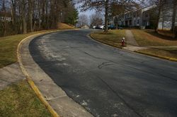
| |
| A crossing with a traffic island (implicit mapping with a property or explicitly to mark a footway or similar on a traffic island crossing). |
The following method is obsolete:
|

|
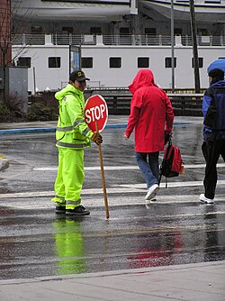
| A supervised crossing (additional property)
Called a school crossing in the United Kingdom, Schülerlotsen or Verkehrshelfer in Germany, Klaar-over in the Netherlands.
|
|
|
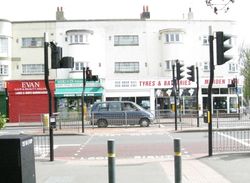
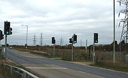
| Traffic signals without a pedestrian crossing.
May be found to give priority to public transport, emergency or special vehicles, when they enter/exit an access service highway (e.g. in first image). May be found used to alternate the direction of traffic on narrow highways (e.g. in second image before entering a bridge). But the crossing with this traffic signal is not suitable for safe pedestrian crossing. |
 
|
Tagging crossings as ways
Some mappers tag a way ![]() segment of a
segment of a highway=footway or highway=cycleway that crosses multiple roads and/or railways with crossing=traffic_signals to indicate that there is only one traffic light controlling the cyclist or pedestrian, to avoid multiple nodes ![]() being tagged as crossings.
being tagged as crossings.
Similarly, a way segment of a highway=footway is being tagged crossing=uncontrolled + crossing_ref=zebra to indicate its full length.
Disadvantage: Please note that this mapping style makes it difficult for routers and navigation systems to recognise that there is a crossing for pedestrians or cyclists along the road since there is no special crossing node ![]() on the route being evaluated.
on the route being evaluated.
Better alternative: For "controlled crossings" with traffic signals or give-way/stop signs you can add the place where you have to stop/where the traffic light or stop sign is as node ![]() with
with highway=traffic_signals, highway=give_way or highway=stop.
See also
crossing:markings=*- The existence and style of pedestrian crossing markings- Approved features/Road crossings - the original proposal for this tag
- Cycle routes - closely linked with many toucan crossings
- Proposed features/Traffic island - an abandoned proposal about traffic islands
- Proposed features/crossing=marked - a proposal on
crossing=markedas a solution to a semantic problem of certain crossing tags - Proposed features/Unambiguous crossings - a page for organising other proposals about improving this key
- Proposed_features/Highway_crossing_cleanup - a proposal for separation of the different properties that are currently mixed in the crossing tag
External links
 Pedestrian crossing - international differences and terminology
- Crosswalks - San Francisco Better Streets