Template:Az:Map Features:natural
Jump to navigation
Jump to search
Природные образования (Natural)
Этот тег описывает физические особенности земельных областей, их вид, в каком они существуют в природе. Этих типы могут быть отмечены как естесственные, даже если они обрабатываются людьми.
| Key | Value | Element | Təsvir | İşarə | Foto |
|---|---|---|---|---|---|
Vegetation | |||||
| natural | fell | Пустыри, территории, заросшие травой | No, see #545. |  | |
| natural | grassland | Areas where the vegetation is dominated by grasses (Poaceae) and other herbaceous (non-woody) plants. For mown/managed grass see landuse=grass, for hay/pasture see landuse=meadow.
|
 |
 | |
| natural | heath | Обширная, довольно ровная область необрабатываемой земли, обычно с грубой неплодородной почвой. Как правило имеется растительность в виде травы или редких кустов, если кустарники преобладают, то natural=scrub.
|
 |
 | |
| natural | moor | Don't use, see wikipage. Upland areas, characterised by low-growing vegetation on acidic soils. | currently not rendered by OSM Carto |  | |
| natural | scrub | Кустарниковые заросли |  |
 | |
| natural | shrubbery | An area of shrubbery that is actively maintained or pruned by humans. A slightly wilder look is also possible | currently not rendered by OSM Carto |  | |
| natural | tree | Отдельно стоящие или выдающиеся деревья |  | ||
| natural | tree_row | A line of trees. |  |
 | |
| natural | tree_stump | A tree stump, the remains of a cut down or broken tree. |  | ||
| natural | tundra | Habitat above tree line in alpine and subpolar regions, principally covered with uncultivated grass, low growing shrubs and mosses and sometimes grazed. |  | ||
| natural | wood | Лесные массивы и скопления деревьев за исключением территорий лесничеств и охотохозяйств, обозначаемых landuse=forest, в том числе: - лесозаградительные полосы в полях, вдоль дорог и т.п.; - лесные массивы, закреплённые за лесничествами, в которых не проводятся вырубка и лесопосадка, в т.ч. охотохозяйства; - лесные массивы с неизвестным статусом; - отдельные небольшие группы деревьев (см. также natural=tree); - лесопарковые зоны, бульвары, парки, заказники (кроме leisure=park, landuse=natural_reserve) Доп. теги: + name=<название леса> + wood=coniferous/deciduous/mixed (хвойный/лиственный/смешанный) |
 |
 | |
|
| |||||
| natural | bay | Заливы, бухты |  |
 | |
| natural | beach | Отлогие береговые зоны, приливные зоны, покрытые камнями, галькой, песком |  |
 | |
| natural | blowhole | An opening to a sea cave which has grown landwards resulting in blasts of water from the opening due to the wave action |  | ||
| natural | cape | A piece of elevated land sticking out into the sea or large lake. Includes capes, heads, headlands and (water) promontories. |  | ||
| natural | coastline | Береговые линии. Используется, когда линии не замкнуты. Рисуем, придерживаясь правила: земля — слева по ходу движения, вода — справа. См. также waterway=riverbank | 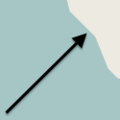 |
 | |
| natural | crevasse | A large crack in a glacier |  | ||
| natural | geyser | A spring characterized by intermittent discharge of water ejected turbulently and accompanied by steam. | 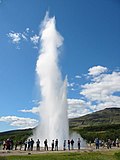 | ||
| natural | glacier | Нетающие ледники |  |
 | |
| natural | hot_spring | A spring of geothermally heated groundwater |  | ||
| natural | isthmus | A narrow strip of land, bordered by water on both sides and connecting two larger land masses. |  | ||
| natural | mud | Gil |  |
 | |
| natural | peninsula | A piece of land projecting into water from a larger land mass, nearly surrounded by water | 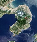 | ||
| natural | reef | A feature (rock, sandbar, coral, etc) lying beneath the surface of the water |  | ||
| natural | shingle | An accumulation of rounded rock fragments on a beach or riverbed |  |
 | |
| natural | shoal | An area of the sea floor near the sea surface (literally, becomes shallow) and exposed at low tide. See natural=sand as well.
|
 |
 | |
| natural | spring | Источники, родники |  | ||
| natural | strait | A narrow area of water surrounded by land on two sides and by water on two other sides. |  |
 | |
| natural | water | Водные поверхности: озёра, водоемы и т.д. Рисуя водоемы нужно придерживаться следующего правила для корректной отрисовки: земля - слева по ходу движения, вода - справа. Т.е. водоём нужно рисовать по часовой стрелке. |  |
 | |
| natural | wetland | Затопленные местности: болота, топи, марши, лаймы. См. также wetland=* |  |
 | |
|
| |||||
| natural | arch | A rock arch naturally formed by erosion, with an opening underneath. | currently not rendered by OSM Carto |  | |
| natural | arete | Острый гребень горы или кряжа |  |
 | |
| natural | bare_rock | An area with sparse/no soil or vegetation, so that the bedrock becomes visible. |  |
 | |
| natural | blockfield | A surface covered with boulders or block-sized rocks, usually the result of volcanic activity or associated with alpine and subpolar climates and ice ages. | Currently not rendered by OSM Carto |  | |
| natural | cave_entrance | Входы в пещеры |  | ||
| natural | cliff | Утёсы, отвесные скалы, обрывы, обрывистые берега |  |
 | |
| natural | dune | A hill of sand formed by wind, covered with no or very little vegetation. See also natural=sand and natural=beach
|
currently not rendered by OSM Carto |  | |
| natural | earth_bank | Large erosion gully or steep earth bank |  | ||
| natural | fumarole | A fumarole is an opening in a planet's crust, which emits steam and gases |  | ||
| natural | gorge | A gorge or canyon, including variants like ravine or slot canyon, is a narrow valley with steep, typically rocky walls. | currently not rendered by OSM Carto |  | |
| natural | gully | Small scale cut in relief created by water erosion |  | ||
| natural | hill | A hill. | currently not rendered by OSM Carto |  | |
| natural | peak | Вершины гор, холмов. Также предлагается добавлять tourism=attraction
|
 | ||
| natural | ridge | Вершина хребта или кряжа |  |
 | |
| natural | rock | A notable rock or group of rocks attached to the underlying bedrock. | currently not rendered by OSM Carto |  | |
| natural | saddle | The lowest point along a ridge or between two mountain tops |  | ||
| natural | sand | Поверхность земли покрытая главным образом песком, без или с незначительной растительностью |  |
 | |
| natural | scree | Каменистые осыпи |  |
 | |
| natural | sinkhole | A natural depression or hole in the surface topography. | currently not rendered by OSM Carto |  | |
| natural | stone | Отдельно лежащий камень, эрратический валун | currently not rendered by OSM Carto |  | |
| natural | valley | A natural depression flanked by ridges or ranges of mountains or hills | currently not rendered by OSM Carto |  | |
| natural | volcano | Вулканы, как действующие, так и потухшие |  | ||
| natural | user defined | На странице Taginfo есть еще частоупотребляемые теги. | |||
This table is a wiki template with a default description in English. Editable here. Burdan cədvəlin Azərbaycan versiyasını redaktə et.


