Template:Generic:ES:Map Features:natural
Jump to navigation
Jump to search
=== Natural ===
| Clave | Valor | Elemento | Comentarios | Representación | Foto |
|---|---|---|---|---|---|
Vegetación o superficie relacionada | |||||
| natural | fell | Zonas montañosas, Habitad por encima de las zonas arboladas en las regiones alpinas y subpolares, cubierto principalmente por hierba sin cultivar, arbustos de bajo crecimiento, musgo y, a veces, pastos. | No, see #545. |  | |
| natural | grassland | Pradera, zona donde la vegetación está dominada por gramíneas (Poaceae) y otras plantas herbáceas (no leñosas), a excepción de hierba ornamental (Véase landuse=grass), siega de heno, etc. (Véase landuse=meadow) y el pastoreo (Véase landuse=forest).
|
 |
 | |
| natural | heath | Tierra baja, despejada y sin cultivar, con pocos arbustos o ninguno. No lo use para parques cuyo nombre contenga "páramo". |  |
 | |
| natural | moor | Páramo, zonas de montaña que se caracteriza por una vegetación de bajo crecimiento que crece en suelos ácidos. | No renderizado por Mapnik |  | |
| natural | scrub | Zona sin cultivar cubierta con arbustos o árboles pequeños. |  |
 | |
| natural | shrubbery | An area of shrubbery that is actively maintained or pruned by humans. A slightly wilder look is also possible | currently not rendered by OSM Carto |  | |
| natural | tree | Marca la posición de un árbol aislado o significativo por alguna razón. |  | ||
| natural | tree_row | Línea de árboles. |  |
 | |
| natural | tree_stump | A tree stump, the remains of a cut down or broken tree. |  | ||
| natural | tundra | Habitat above tree line in alpine and subpolar regions, principally covered with uncultivated grass, low growing shrubs and mosses and sometimes grazed. |  | ||
| natural | wood | Bosque primigenio. Exclusivamente para bosque salvaje y sin gestión. Para los bosques propietarios y gestionados se usa landuse=forest. Si quiere detallar mejor use leaf_type=*.
|
 |
 | |
Relacionados con el agua | |||||
| natural | bay | Bahía, gran zona de agua parcialmente encerrada por la tierra pero con una gran entrada. |  |
 | |
| natural | beach | Playa, zona llana de arena, grava o gravilla junto al agua. |  |
 | |
| natural | blowhole | An opening to a sea cave which has grown landwards resulting in blasts of water from the opening due to the wave action |  | ||
| natural | cape | A piece of elevated land sticking out into the sea or large lake. Includes capes, heads, headlands and (water) promontories. |  | ||
| natural | coastline | Línea de costa, altura media de las mareas. El agua se muestra en el lado derecho de la vía. | 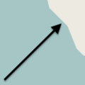 |
 | |
| natural | crevasse | A large crack in a glacier |  | ||
| natural | geyser | A spring characterized by intermittent discharge of water ejected turbulently and accompanied by steam. | 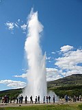 | ||
| natural | glacier | Glaciar, zona de nieve perpetua. Pueden darse en los picos. |  |
 | |
| natural | hot_spring | A spring of geothermally heated groundwater |  | ||
| natural | isthmus | A narrow strip of land, bordered by water on both sides and connecting two larger land masses. |  | ||
| natural | mud | Lodazal, ciénaga. Zona con barro. Etiqueta no documentada. Vea también natural=wetland acompañado de wetland=*.
|
 |
 | |
| natural | peninsula | A piece of land projecting into water from a larger land mass, nearly surrounded by water | 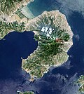 | ||
| natural | reef | A feature (rock, sandbar, coral, etc) lying beneath the surface of the water |  | ||
| natural | shingle | Guijarros, zona con acumulación de rocas erosionadas por el agua, guijarros y grava, aunque podrían ser mayores. |  |
 | |
| natural | shoal | An area of the sea floor near the sea surface (literally, becomes shallow) and exposed at low tide. See natural=sand as well.
|
 |
 | |
| natural | spring | Fuente o manantial natural. Lugar donde el agua subterránea aflora de forma natural de la tierra. |  | ||
| natural | strait | A narrow area of water surrounded by land on two sides and by water on two other sides. |  |
 | |
| natural | water | Agua, lagos, lagunas, etc. |  |
 | |
| natural | wetland | Área húmeda, marisma, humedal. | 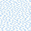 |
 | |
Relacionados con el accidente geográfico | |||||
| natural | arch | A rock arch naturally formed by erosion, with an opening underneath. | currently not rendered by OSM Carto |  | |
| natural | arete | Arista, cresta delgada de roca que normalmente se forma cuando dos glaciares erosionan valles paralelos en forma de U. | No renderizado por Mapnik |  | |
| natural | bare_rock | Roca expuesta. Área con vegetación escasa o nula, por lo que el suelo rocoso es visible. |  |
 | |
| natural | blockfield | A surface covered with boulders or block-sized rocks, usually the result of volcanic activity or associated with alpine and subpolar climates and ice ages. | Currently not rendered by OSM Carto |  | |
| natural | cave_entrance | Entrada a una cueva. |  | ||
| natural | cliff | Acantilado, pared de roca vertical o casi vertical (deje el lado más bajo a la derecha de la vía). | 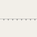 |
 | |
| natural | dune | A hill of sand formed by wind, covered with no or very little vegetation. See also natural=sand and natural=beach
|
currently not rendered by OSM Carto |  | |
| natural | earth_bank | Large erosion gully or steep earth bank |  | ||
| natural | fumarole | A fumarole is an opening in a planet's crust, which emits steam and gases |  | ||
| natural | gorge | A gorge or canyon, including variants like ravine or slot canyon, is a narrow valley with steep, typically rocky walls. | currently not rendered by OSM Carto |  | |
| natural | gully | Small scale cut in relief created by water erosion |  | ||
| natural | hill | A hill. | currently not rendered by OSM Carto |  | |
| natural | peak | Pico, cima de un monte o una montaña. |  | ||
| natural | ridge | Cresta o cadena montañosa, sucesión de varios picos de altura similar. | No renderizado por Mapnik |  | |
| natural | rock | Una roca notable o grupo de rocas con conexión a tierra. | No renderizado por Mapnik |  | |
| natural | saddle | Un collado o punto de silla, el punto más bajo entre dos colinas cercanas. |  | ||
| natural | sand | Banco de arena, arenal. Terreno cubierto de partículas de silicio sin vegetación o siendo esta muy escasa. Vea también natural=beach.
|
 |
 | |
| natural | scree | Pedregal, zona de rocas rugosas sin consolidar, formado por la caída de piedras y meteorización de las paredes pétreas adyacentes. |  |
 | |
| natural | sinkhole | Sumidero, sima. Depresión natural u hoyo en la topografía de la superficie. | No renderizado por Mapnik |  | |
| natural | stone | Posición de una roca grande y aislada. | No renderizado por Mapnik |  | |
| natural | valley | Valle, depresión entre montañas generalmente excavada por un curso de agua. | No renderizado por Mapnik |  | |
| natural | volcano | Cima de un volcán activo, dormido o extinto. |  | ||
| natural | user defined | Los valores usados según Taginfo. | |||
This table is a wiki template with a default description in English. Editable here.


