Uk:Tag:aeroway=runway
 |
| Опис |
|---|
| Довга прямокутна ділянка сухопутного аеродрому, призначена для посадки і зльоту повітряних суден. |
| Зображення в OSM Carto |

|
| Група: Aeroways |
| Застосовується до цих елементів |
| Використовується разом з |
| Дивись також |
| Статус: де-факто |
| Інструменти |
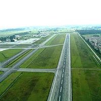
Злітно-посадкова смуга – це видовжена прямокутна ділянка аеродрому (aeroway=aerodrome) спеціально сконструйована для посадки та зльоту літаків.
- Див вертолітні майданчики
aeroway=helipad. - Для гідропланів використовуйте
seamark:type=seaplane_landing_area.
Як мапити
Накресліть лінію вздовж осі злітно-посадкової смуги, від краю до краю, та позначте її теґом aeroway=runway. Дані про її ширину потрібно зазначати за допомоги теґу width=* (див далі).
В той же час, креслення периметру злітно-посадкової смуги та позначення його теґом aeroway=runway також є поширеною практикою. За бажання, ви можете накреслити периметр та позначити його теґом area:aeroway=runway (подібно до area:highway=*). Taginfo каже що комбінація aeroway=runway + area=yes була використана понад 2500 разів, а area:aeroway=runway – 1911 станом на квітень 2021.
Додаткові теґи
ref=*– позначення смуги (напр. "02/20" чи "09L/27R"). Вкажіть на початку менше значення (тобто "04/22", а не "22/04"). Значення завжди матимуть різницю, що дорівнює 18 (180°) і вони можуть доповнюватись літерами (L, C або R). Інші значення використовуйте лише у особливих випадках.length=*– може використовуватись для зберігання інформації про фізичну довжину злітно-посадкової смуги включаючи кінцеву смугу безпеки, зміщений поріг та ін. Це значення зазвичай більше, ніж фактично доступна ділянка для зльоту та посадки. Значення в метрах, або зазначайте одиниці виміру. ('100' – сто метрів, або '200 ft' – 200 футів.width=*– вказує ширину поверхні злітно-посадкової смуги (ширина бетонки, або трав’яного газону, втрамбованого ґрунту, в залежності від типу покриття смуги). Ширина зазвичай є стандартною, типові значення: 60 м, 45 м, 30 м, 23 м або 18 м. Використовуйте інші значення лише в особливих випадках. Ви також можете зважити на використання теґуwidth:strip=*для позначення можливої ширини розмаху крил, доступні габарити позначаються білими конусами по боках смуги.ele=*– середня висота злітно-посадкової смуги над рівнем моря.surface=*– тип поверхні злітно-посадкової смуги. Напр: "paved" або "grass".name=*– якщо злітно-посадкова смуга має власну назву. Не потрібно копіювати значення ref=*. Напр: "Polderbaan" та "Aalsmeerbaan" в аеропорту Амстердама.
Додаткові відомості
Додаткові відомості можуть бути зазначені за допомогою наступних теґів:
| Теґ | Опис |
|---|---|
| Date | source:date=* - If imported/updated from the FAA 56-day NASR database, this tag will contain the date the database became valid.
|
| Incline | Use the incline=[+|-]d.d% tag for the % incline of the runway. The direction of the way is from approach to departure. The incline is the elevation at the departure threshold minus the elevation at the approach threshold, divided by the distance between them.
|
| Incline spec | incline:spec=[+|-]d.d%: the % incline of the runway, as specified in the FAA airport diagram. According to the legend diagram, this is measured to the midpoint of the runway (instead of the far threshold) if the runway is >= 8000ft, and is only specified if the absolute value is >= 0.3%. Note that this tag is used only if the incline is in the same direction as the runway. Otherwise, the reverse_incline tag is used (see reverse_incline:spec=* below).
|
| Landing Facility Site Number | The FAA's Landing Facility Site Number for the airport with which the runway associated should be tagged with FAA:LFSN=*. There is generally no reason to edit this value - it is used to refer back to the associated aeroway=aerodrome node or way and the FAA database for synchronization of imports. Example: "01818.*A" is the LFSN for LAX.
|
| Reverse incline | reverse_incline:spec=[+|-]d.d%: the % incline of the runway as specified in the FAA airport diagram, in the reverse direction of the OSM way. See incline:spec=* above.
|
| Source | source=* - Source(s) of information present in tags, semi-colon-delimited if necessary. "FAA" indicates at least some information from one or more FAA databases or imports. Often combined with an imagery tag to indicate the imagery with which the boundary was drawn.
|
| Source_ref | source_ref=* - Key to source documents. Example: when source=FAA, you may see source_ref=nnnnnAD, which indicates the document number of the FAA Airport Diagram, which are at http://aeronav.faa.gov/d-tpp/vvvv/''nnnnn''AD.PDF where vvvv is the version number (incremented every 56 days).
|
| Lit | Add lit=* to indicate whether the runway is lit. If lit=yes is used, edge-lights are assumed to be present. Add lit:centre=yes to indicate the presence of centreline lights.
|
Lifecycle
- Основна стаття: Lifecycle_prefix
| stage | tagging | notes |
|---|---|---|
| construction | aeroway=constructionconstruction=runway |
A runway under construction. |
| In operation | aeroway=runway |
An operational runway |
| disused | disused:aeroway=runway |
A runway not in use, which could be brought back into operation. |
| abandoned | abandoned:aeroway=runway |
Where the runway fallen into serious disrepair and which could only be put back into operation with expensive effort. |
| No longer present on the ground | Remove from OSM or tag no:aeroway=runway |
Where the runway is not evident on the ground it should be removed from OSM. If there is a danger of it being re-entered from old information then no:aeroway=runway signifies that it is no loner there.
|
Example
| Picture/Description | Tags | OSM Carto |
|---|---|---|

|
aeroway=runwayref=06/24
|
See Munich International Airport for a reference.
See also
aeroway=highway_strip- for an emergency strip on a roadway.aeroway=taxiway- for a taxiway used by aircraft to access runways from aircraft parking areas in an airport.aeroway=helipad- A landing area or platform designed for helicoptersaeroway=launchpad- A launchpad or landing pad for spacecraft
External links
| ||||||||||||||||||||||||||||||||||||||||||||||||||
