Talk:Railways
Discussions from talk on key:railways
I have moved the discussions about tagging from the talk:key:railway page to this page to get them all into one place.
highway=motorail?
There are several locations in Switzerland with a train tunnel through the mountains, but no one for cars. Therefore, cars can be loaded onto special trains for transportation across the tunnel. As the travelling time is relatively short (usually <15min), people stay inside their cars. Service hours are usually 5-22, interval depending on demand (usually 1x - 5x per hour).
Two ways of mapping this came to my mind:
- For ferries, the use of motorcar/foot/...=yes/no is common to specify what is transported. This could be adopted for these trainlines. -> motorcar=yes
- a new highway=motorail could be introduced, which would be combined with the existing railway=rail/light_rail
same as with ferries, some information about service hours, intervals and duration should be added. see Talk:Tag:route=ferry
--RalpH himself 12:42, 24 March 2009 (UTC)
- Proposed features/shuttle_train seems to be being used, and this is what the Channel Tunnel is tagged with (with a pair of additional hidden ways parallel, but not connected to the railway lines. —Sladen (talk) 08:12, 18 May 2013 (UTC)
amount of tracks per line
Often there are multiple lines per track, eg. one for trains traveling west and one for trains traveling east. Do I map just one single line ( drawing just one line and labeling it 'track' ) or do I map each track ? If I draw just one single line, how do I have to label it to tell the amount of tracks ? Thomas P 18:30, 21 June 2008 (UTC)
- I would say one single line. Gustavf 07:16, 24 September 2008 (UTC)
- I would say multiple lines, because in high zoom levels it is neccessary to see all tracks to get a good map. Otherwise it would look like if there is much space between road and rail even if they are close together.
- An other problem is, that in most cases, people draw all tracks if they are on a station and return to one single line after, even if there are two of them. I think you should be able to see right from the map, if there are multiple tracks or just a single. With the current rendering- an tagging-system this is not possible.
- Example: http://www.openstreetmap.org/?lat=52.37588&lon=9.74453&zoom=17&layers=B000FTF
- each track drawn here consists of two lines.
- Same problem exists for stations, they are often described as nodes. In my oppinion this is wrong, because stations often are big areas, that would apear empty, if a station is only described as a node.
- Example: http://www.openstreetmap.org/?lat=37.3407084154401&lon=-121.885297984984&zoom=14
- in reality there are two main lines and one holding track.
- --CeBe 12:36, 3 December 2008 (UTC)
- The station node is supposed to be part of the rail. It is used to show where trains stop. There are other tags for buildings and platforms and landuse. --Skratz 06:11, 3 January 2009 (UTC)
- I don't think there is any perfect solution here. I see some similarities with roads here, and they can be tagged with number of lanes, and something similar could probably be done for railways. If normal rail should have to have one line for each direction, you shuld probably do this for tramway as well, and when these follow a road you end up with two lines for the tramway, but only one for the road... -- Gustavf 22:31, 27 May 2009 (UTC)
- Such is life with tram tracks. Yet I wouldn't bother drawing two separate tracks for some long inter city sections, unless I were a railway worker with data to map the railroad switches, too, on that section. Alv 06:21, 28 May 2009 (UTC)
We should have something like key:lanes, like we have for motorways. Then it would be sufficient to map a double (or more) line track only once. Right now, when two lines are mapped, they are often too far away (besides the double work). In stations, these can be split again into single lines which are wider apart, as mostly a platform is in between. --MattGPS 01:57, 28 July 2009 (UTC)
- I would like to add some input and clarifications. With the proliferation of new high speed lines, especially in China, I see no value in separating a single trace with "tracks=2" into two separate parallel rail lines. To construct, and also modify, two (PDL) separate lines requires double the effort, difficulty to get decent renderings, and the results are often messy. With two lines constructed together on one single roadbed (eg. PDL slab track), the trivial and superior solution is a single line.
- If the railway lines actually diverge, such as on separate bridges or tunnels, then the lines can be drawn separately to indicate this. When the two lines are actually constructed separately, and also frequently diverge, then there is value in drawing two separate lines. Also in this instance, deviations in drawing the routes are not obvious.
--Badenk (talk) 20:22, 3 August 2020 (UTC)
- On California/Railroads, many OSM volunteer editor / contributors continue to make efforts to review and improve a data-noisy 2007-8 USA-wide import ("TIGER") of roads and rails. Focusing on rails here (and in California), we recently managed to completely eliminate
tracks=*in the entire state (tens of thousands of kilometers of rail). This took some effort, as it was a regional goal among us (who edit rail in the USA) to do so, since we want OSM to be as close to "a faithful, exact model" of the railway infrastructure as possible. Usingtracks=*was a shortcut in some cases where such modeling was complex and/or time-consuming to complete, but efforts to eliminatetracks=*have paid off with our resultant "fully modelled" rail infrastructure. Of course, thetracks=*tag exists for exactly this reason, so please do not hesitate to use it (e.g. in China where stretches of multiple-carriageway rail continue for long-distances, and at junctions, etc., exceptions can be added as just that — exceptions). However, please do recognize usingtracks=*as a stopgap measure: OK in the short- to intermediate-term, but ultimately better represented by fully-realizedrailway=*infrastructure. So, there is "some value" (not "no value") in both approaches: usingtracks=*can allow quicker modelling of rail, not usingtracks=*(and deliberately so) results in fully modelling of rail. Stevea (talk) 20:39, 3 August 2020 (UTC)
- On California/Railroads, many OSM volunteer editor / contributors continue to make efforts to review and improve a data-noisy 2007-8 USA-wide import ("TIGER") of roads and rails. Focusing on rails here (and in California), we recently managed to completely eliminate
keys on nodes
It says that the railway key cannot apply to nodes, but Map features#Railway states that a node feature can have the railway key with values station, halt, ...
So, which is it? ;) --KristianThy 19:48, 6 December 2006 (UTC)
- The page only talks about the linear applications of key:railway. station, halt... surely apply to nodes. -- Eckhart 22:30, 6 December 2006 (UTC)
- And railway=level_crossing. I also use railway=junction as a reminder that I've noted a branch line junction at that point that needs surveying/tracing from out-of-copyright maps Welshie 11:27, 7 December 2006 (UTC)
- Fixed. Don't know why it said No. Blackadder 14:18, 7 December 2006 (UTC)
- And railway=level_crossing. I also use railway=junction as a reminder that I've noted a branch line junction at that point that needs surveying/tracing from out-of-copyright maps Welshie 11:27, 7 December 2006 (UTC)
railway and highway on one way?
Question: Should one way use both keys (highway and railway) on one way-segment if the are in reality on one track? In this case the tram-rails are in the street. Cars and tram share the same way. Example for this can be found here. --Bahnpirat 10:13, 3 November 2007 (UTC)
- I make this as one way with both tags. The name of the tramline should be part of the tram-relation, since the tramLINE has usually a name, not the tramTRACKS. Same with oneway-street, but tram in both directions or otherwise: oneway=* belongs to the road, the direction of the tram should be marked as the role of the relation. But I admit, there are still some limitations. RalpH himself 13:08, 24 March 2009 (UTC)
Similar Question: I have come across the following problem in Toronto. It arises when you have a road with a tram line down it. The road has a name, and the tram line has a different name. This has been mapped as two ways using the same nodes. In JOSM, you can only see one of the ways, which tends to be the tram line. You cannot see the road. If you try moving the tram line to see the road, the road moves with it, of course. You can tell it is there by middle-clicking, but you cannot change it.
I would like to change this so there is one way with the highway and the tram line as two properties. Is that a good idea? Presumably the name property would be the street name. But then what key should be used for the tram line name? Mmather 23:19, 9 December 2007 (UTC)
You can too select it in JOSM. Try pressing control and middle click. Morwen 00:49, 10 December 2007 (UTC)
I can see the properties with middle click. But Ctrl-middle click does nothing. (I am using version 441.) Mmather 21:15, 15 December 2007 (UTC)
- Again, I have a similar problem, but with a full-sized railway going down the center of a street. It is neither a much-used street or a much-used railway, but they take the same route for two blocks. I've tagged it as both highway=residential and railway=rail (though I'm going to change it to railway=spur). However, on osmarender, it only draws the street but shows each place where it crosses another street as an at-level crossing. This apparently isn't common, but it does happen. Some rules should be made for renderers so that they show both. — Val42 01:58, 1 November 2008 (UTC)
New tagging schema...
As stated in the main article, the disctinction between the various tag, rail, tram, light_railway, metro is not easy, many of them using exactly the same infrastructure. A more natural way, would to tag the infrastructure, also easier for a novice :
- gauge : standard (1435mm),broad, metric and narrow
- number of track
- status: in service, disused, abandonned, preserved
- electrified or not (and maybe type contact line, rail)
- special attributes: third rail (multi-gauge), TGV (high-speed), rack (steep climb), etc..
- tunnel=yes, bridge=yes
- for specialists: type of signalisation, spannung, gabarit
An then adding the various route or line, could help to check the consistency of the infrastructure
Gummibaerli 23:18, 15 December 2007 (UTC)
- I independnetly arrived at a simmilar conclusion :) ShakespeareFan00 17:23, 13 April 2008 (BST)
- There is an objective tag that could be added : UIC ranking (UIC is International Union of Railways). All railways in the world have a rank (from 1 to 9) according to their traffic, max speed, etc...
Proposal
I propose that the railway tag can be further broken down into 5 main categories.
railway:competence=other;federal
Legislative authority of the railway.
- Other: Other than federal authority.
- Federal: Railway governed by federal laws.
railway:gauge=unknown;narrow;standard;special
Type of track based on the distance between the two rails.
- Unknown: Impossible to determine the gauge from the data source.
- Narrow: Railway with a gauge of 0.967 m.
- Standard: Railway with a gauge of 1.435 m.
- Special: A railway-like feature, such as a subway or miniature railway.
railway:status=unknown;under_construction;non_operational;operational
Status of the railway.
- Unknown: Impossible to determine the railway status from the data source.
- Under construction: Railroad under construction when the field survey was carried out.
- Non-operational: Railway no longer suitable for rail traffic.
- Operational: Any useable or used railway.
railway:support=unknown;ground_level;snowshed;bridge;tunnel
Portion of a railway having a structure to cross an obstacle.
- Unknown: Impossible to determine the railway support from the data
source.
- Ground level: Railway built directly at ground level.
- Snowshed: Roofed structure built over a railway in mountainous areas to
protect railway from snow slides.
- Bridge: Railway built on a raised structure spanning an obstacle.
- Tunnel: Railway built in a cavity or underground structure to get
through or under an obstacle.
railway:type=unknown;other;multiple;single
Description of existing infrastructure.
- Unknown: Impossible to determine the railway type from the data
source.
- other: Any known railway section that is not categorized as multiple
or unique, such as a siding, passing track, spur, etc.
- multiple: More than one railway on the same roadbed.
- single: Railroad with only one railway.
It seems the wiki isn't as detailed.... so im looking for help, on matching tags.. so then perhaps only a couple of tags could be proposed. re: CanVec: Transportation (TR) --acrosscanadatrails 07:40, 27 February 2009 (UTC)
- What about other gauges (like 1676mm in Spain)? Many of your proposals are obsolete since they already exist (bridge, tunnel, non-operational (=disused), spurs...) or are under development/discussion (snowshed, gauge...) RalpH himself 19:14, 24 March 2009 (UTC)
... and rendering ?
The symbol (ladder) used in osmarender to render railway is OK for preserved railways, but not for TGV. Railways should be a red or black line, narrow gauge something like the actual symbol (dashed black(white)
Stations are more a line element than a node
Gummibaerli 09:03, 16 December 2007 (UTC)
- Area? The station can span several platforms/tracks in different directions and on different levels, be open or under roof, have one or more buildings. --Skippern 15:50, 5 December 2008 (UTC)
level_crossing
does level_crossing only apply to crossings between raods and rail tracks? There are examples of level crossings of rail tracks with other railtracks. Can this tag be used? --Dschwen 16:12, 14 August 2008 (UTC)
crossing/level_crossing without gates
Is there a possibility to tag the absence of gates ? I mean its a huge difference in the crossing wether there are gates or not and level_crossing implies their existance for them. Do other tag with e.g. gates=no or something? Flohoff 16:44, 20 August 2008 (UTC)
- The types of level-crossings that I've seen, from least to most controlled:
- No signage
- "Private crossing": A sign near crossing, but no other indicators
- Railroad-crossing: Signs at crossing
- Flashing light: Sign with always-flashing light indicating railroad crossing
- Flashing indicators: Lights flash when a train is approaching, but no gates
- Flashing gates: Lights flash and gates lower when a train is approaching
- Gates with lane dividers: Flashing gates plus dividers to keep vehicles from (easily) going into the other lane to bypass gates
- Double gates: Gates come down blocking both lanes from both sides of the track
- Currently, there is only one indicator of a level-crossing: a red "X" across the crossing. These different levels of crossing could be rendered differently. However, would this be an acceptable list and what would the keywords be? — Val42 07:42, 7 October 2008 (UTC)
gauge
I know little about what the definition of different tracks (normal / narrow gauge) but know of means to find out what the actual gauge are. Wouldn't it be simpler for us non-rail people to tag light-rail/rail/narrow gauge as railway=rail and add a gauge=* to specify the track width? As I understand it, a light-rail can run on the same tracks as the main line.... how do I know the difference? BTW, I can look up type of gauge on the internet for the lines in question, in Brazil where I live at least 3 different gauge types are in use. --Skippern 15:45, 5 December 2008 (UTC)
"Designation not to be used"
The description for "abandoned" says "Designation not to be used if the feature has been turned into another use, eg cycleway." IMO, this contradicts the actual practice, and effectively amounts to telling people to not record what may well be a relevant fact, so I suggest this sentence is removed. Chriscf 13:06, 15 January 2009 (UTC)
- I do not see any problem in combining an abandoned railway with a cycle or footway. I suggest to change that sentence into something like: "If reused as an other way (eg cycleway) add that tag too." Is there a discussion on this topic on talk? --Torstiko 09:11, 30 January 2009 (UTC)
- One caveat: do not tag the same way as
highway=cyclewayandrailway=abandoned, but rather use two ways for them (perhaps sharing the same nodes). Otherwise you'll get for example rendering problems. --Eimai 19:16, 11 February 2009 (UTC)- If there are rendering problems, the solution is to fix the renderer, not break the data. Chriscf 19:30, 11 February 2009 (UTC)
- It's just the same as not tagging the same way as a
railway=tramandhighway=residential. Putting the two on the same tag will also give problems with certain tags that can become ambiguous, likename=*. The abandoned railway and the cycleway can both have different names. --Eimai 20:25, 11 February 2009 (UTC)- So you use the name of the current feature, and another tag like railway_name for the former name. The same thing happens if you have a named bridge along a named road, but we don't duplicate the bridge. --NE2 07:26, 4 April 2010 (UTC)
- It's just the same as not tagging the same way as a
- If there are rendering problems, the solution is to fix the renderer, not break the data. Chriscf 19:30, 11 February 2009 (UTC)
- One caveat: do not tag the same way as
Specialization of tram/subway-stop tagging
Hi everyone. During my mapping of PSV and especially PSV stops I wondered if there is any common scheme, to define the type of a stop. Because one should set the stop onto the rails, there are many important things to look at:

Probably we should introduce some new tags. The last, centered block could be partly used for buses as well.
Any ideas how to tag this at the moment?
I saw many stops with a high platform being tagged as railway=halt and many with a low one as railway=tram_stop.
Hope to get any comments. --E-Malte 20:27, 12 February 2009 (UTC)
good station
At the moment there is no tag for good stations or freight depot. These stations have also a reference-number (code-number). --KartoGrapHiti 12:45, 19 February 2009 (UTC)
Maxspeed
Should Key:maxspeed be in Additional Features? The information is necessary to render a map like this. ChrisB 00:20, 8 October 2009 (UTC)
Rendering of disused railways
Osmarender renders a quaint little faded railway when confronted with the railway=abandoned tag; why doesn't Mapnik do the same or similar? Kevin Steinhardt 20:36, 26 October 2009 (UTC)
Maglev
railway=maglev should be added. Now maglev lines are mapped as monorail. Python eggs 05:37, 10 December 2009 (UTC)
- Or
railway=monorail+ traction=maglev could be an extension of the proposal for the traction tag. --Cartinus 07:05, 10 December 2009 (UTC)
Why is light_rail separate from tram?
Light rail is essentially a tram with newer equipment - in other words, the infrastructure is the same. There's no difference between tram and light rail tracks. The mention of metro in light_rail is even worse; subway is a type of metro, and is a higher standard than tram/light rail. I'm proposing that we use subway for all metros (which is already the standard in at least some places; Chicago's mostly-elevated system uses subway for instance) and combine tram and light_rail, since there's no good way to distinguish between them.
Alternately, we could go entirely by form rather than function, and use light_rail for any private right-of-way segments, and tram for any street running. The current Mapnik rendering (not showing street-running light_rail or bridges on tram) would seem to suggest this, but it should probably be treated as a bug in the renderer. --NE2 07:22, 4 April 2010 (UTC)
- I thought I had mentioned the subway/rapid transit deal before; I did on Talk:Railways#'subway' should include all rapid transit. There's too much redundancy on this wiki that makes it hard to fix inconsistencies. --NE2 08:06, 4 April 2010 (UTC)
- Another possibility would be a simple
railway=railfor everything that currently exists, and useservice=tramlikeservice=spuris preferred overrailway=spur. --NE2 08:08, 4 April 2010 (UTC) - I've compiled data for North America (the main user of the term "light rail" for tramways) at User:NE2/North American transit. --NE2 09:18, 4 April 2010 (UTC)
Retarder
http://en.wikipedia.org/wiki/Retarder_%28railroad%29
I think it should be mapped either with retarder=yes on a part of railway=rail or as a point with railway=retarder.
Signals
How should I tag railway signals? Perhaps I could use something like railway=signal. However, should it be located on the track at the node where trains are supposed to wait, or off the track on a separate node where the actual signal post is?
- Without really having an opinion on that yet, it's good to take into account that railways often(?) use preliminary signals hundreds of meters (even km's) before the actual signal, which then may not be passed without a "track clear" signal. Alv 11:52, 14 February 2011 (UTC)
usage=interchange
An interchange track joining two railway's systems. It is neither a spur nor a siding (although it can incorporate them), and it is not really a branch line. Any objections to adding usage=interchange?
- Why usage rather than service? --NE2 11:23, 30 March 2011 (BST)
- My impression is that service describes particular detailed track features, while usage applies to entire lines or sections of the network, describing their general purpose. An interchange can also include spurs and sidings, but it doesn't overlap with the other items in key:usage. —Michael Z. 2011-03-30 20:45 z
- Maybe we're thinking of different things. I see an interchange track as a relatively short track where two lines of different companies cross or parallel. If it includes spurs and sidings, other than sidings used to store interchange cars, it's more than just an interchange track. --NE2 06:13, 31 March 2011 (BST)
- An interchange can be either. Some examples
- A single curve at a junction: e.g., CEMR–CPR in NW Winnipeg
- A short track, but with an industrial spur: CNR–GWWDR interchange in St. Boniface
- A short length of track between two company's yards, but also having spurs connecting local industry and an interchange to yet a third railway: CPR–GWWDR in St. Boniface
- Interchange track is not usage=main nor usage=branch, and usually not usage=industrial, usage=military, or usage=tourism. It is also not service=yard, service=siding, nor service=spur. Since it runs between usages, but may still serve as the trunk for services, I think it is a usage, but calling it a service would probably work too. —Michael Z. 2011-04-06 16:24 z
- My point is that the spurs are not part of the interchange trackage, but just normal spurs that happen to branch off trackage used primarily for interchange. They may be jointly owned, but this is also true for some "normal" spurs that are served by two companies. I don't really care about service vs. usage, but see usage as a more subjective tag (since there's no clear line between main and branch). --NE2 18:17, 6 April 2011 (BST)
- No problem with that situation. I would tag the interchange track as usage=interchange (or service=interchage), and the spurs as service=spur. I don't think ownership affects the tagging, and is likely impossible to determine in most cases, by most mappers. I'm sure many spurs are owned by the local industry, or whatever. Are you thinking of the operator=* tag? —Michael Z. 2011-04-06 23:29 z
service=crossover
A crossover is a short track connecting two parallel tracks. I've been marking these as service=siding, but that's not right because a crossover isn't used for car storage. service=crossover seems logical.
Example: two crossovers on the two-track main line of the CNR Rivers subdivision in Winnipeg. —Michael Z. 2011-04-06 16:36 z
They're certainly not sidings. I've been treating them as unnamed segments of main line. --NE2 18:13, 6 April 2011 (BST)
- I guess that's valid in many cases, but how to tag crossovers between the line and a long siding? Mapnik's rendering of service=siding with a lighter weight improves readability, and would be good for crossovers too. (I haven't checked how service=crossover renders—must try it) —Michael Z. 2011-04-06 23:33 z
- Oh, then I'd use service=siding, just like the portion at the end of the siding that fouls the main (and thus can't be used to store cars). --NE2 00:47, 7 April 2011 (BST)
- That's what I've been doing so far, although that wrongly implies that this is a siding, or track that can be used as a siding. Also wyes and storage tracks, which arguably do serve a similar function to sidings.
Merge (with Mapping/Features/Railway)
This page has now been merged. That included a thorough clean-up and polish too. Martin Renvoize 18:02, 10 December 2009 (UTC)
There is a proposal to merge Mapping/Features/Railway into this article. I suggest that given that the other article is much more established that we should do the merge the other way round. I also suggest that we should avoid duplication of information on the Key:railway page. What we certainly don't need is two articles on the same subject and I wasn't aware of the other one when I started this one. PeterIto 21:23, 16 August 2009 (UTC)
Tables
I'm not sure the tables on this page are the most useful/usable way of showing the relevant tags (I copied them from Mapping/Features/Railway). Any better ideas? Frankie Roberto 13:40, 7 August 2009 (UTC)
Done Martin Renvoize 18:02, 10 December 2009 (UTC)
Trams
AFIAK all trams in the UK are standard gauge. I imagine most elsewhere in Europe are metre gauge. SK53 12:57, 7 August 2009 (UTC)
- I think you're right. There's now a trams page to document the tagging of tram systems, if you're interested... Frankie Roberto 13:41, 7 August 2009 (UTC)
Gauge
Tagging and rendering of railway gauge could be improved. The obvious points are: 1: In the UK narrow gauge railways usually have a very narrow gauge (under 2 ft/60 cm). Elsewhere there are railways with a metre gauge which in all other respects are similar to main line railways: the most obvious example is the Rhaetische Bahn in the Grisons (Graubuenden) Switzerland, but also see Montreux-Oberland Bahn (MOB), and the train network in the Upper Rhone Valley. Current tagging and rendering could be improved to distinguish these full service railways from the UK style heritage narrow gauge lines. 2: Elsewhere lines run on wider gauges than standard: for instance in Spain, Ireland and Russia. SK53 12:57, 7 August 2009 (UTC)
- Should we use
gauge=*for this? What would the value be - in metres (eggauge=1.435)? I'd suggest this would only be worth the effort on tracks that aren't "Standard gauge", as otherwise it'd be a lot of boring tagging... Frankie Roberto 13:43, 7 August 2009 (UTC)
- Should we use
- It should be possible to add tags such as this to a relation that covers a number of individual ways. As long as it was understood that the ways 'inherited' tags from the relation unless they were over-written by the way itself. Tag inheritance would get more complex if a way was in a number of relations that provided different values for the same tag. PeterIto 18:51, 7 August 2009 (UTC)
- Hmm, I guess the gauge tag would have to belong to the "infrastructure" relation rather than any "train service" relation. I think I'd still probably tag the actual ways (as it's unlikely to change very often, and feels like its an intrinsic property of the physical way, rather than the relation entity) - but I think both ways could be encouraged. I'm not sure whether the unit should be specified (
gauge=1.435orgauge=1.435m) - will have a look and see what other similar tags do (eg maxspeed and so on). Frankie Roberto 09:59, 8 August 2009 (UTC)
- Hmm, I guess the gauge tag would have to belong to the "infrastructure" relation rather than any "train service" relation. I think I'd still probably tag the actual ways (as it's unlikely to change very often, and feels like its an intrinsic property of the physical way, rather than the relation entity) - but I think both ways could be encouraged. I'm not sure whether the unit should be specified (
- Leaving out the units makes the key easier for applications to use. Please don’t take broken tags as a precedent. --Wynndale 18:22, 8 August 2009 (UTC)
- For Maxspeed the conclusion of the discussion on tagging km/h or mph in the UK was that the default for units should be metric, but in places where the official unit is something else then that unit should be used and should be appended. So '50' = 50 km/hm whereas '30 mph' means 30 miles per hour. The conversion to metric for UK speed limits was discouraged PeterIto 16:53, 9 August 2009 (UTC)
- Leaving out the units makes the key easier for applications to use. Please don’t take broken tags as a precedent. --Wynndale 18:22, 8 August 2009 (UTC)
- Cool, let's go with that then (default to metric, add unit if in other units). Presumably, for
gauge=*we'd assume a default of metres rather than kilometres, although millimetres would also be an option. I'll create thegauge=*page and will summarise this discussion there. Frankie Roberto 21:03, 9 August 2009 (UTC)
- Cool, let's go with that then (default to metric, add unit if in other units). Presumably, for
- Meter is the base SI unit for length so let's use that one, however we should always specify what the default unit is or people might start suggesting we should use meters per second for speed limits! PeterIto 07:43, 10 August 2009 (UTC)
- OK, my various thoughts. Agree gauge should be the tag and by default in metres. I would also agree that it should be unnecessary to tag standard gauge lines. It might be sensible to allow old lines to be specified in feet and inches as this would be more precise (after all standard gauge was originally 4 ft 8.5 inches, not 1.425m). I would also suggest a value
gauge=standardbe supported as a default, but not other textual descriptions: this is precisely the problem with using narrow gauge at the moment. This covers railways which are very different, from toy trains, many old UK mineral railways run as heritage railways upto metre gauge lines which are a passenger might not even notice are different from main line standard gauge. Also agree this tag belongs on the infrastructure: don't think we've had any mixed gauge running since about 1880 and then only on the GWR. Would also add there are several metre gauge lines in Switzerland with on-road running, e.g., La Presa on the RhB Bernina line. SK53 16:14, 10 August 2009 (UTC)
- Is "standard" gauge sufficiently standard to enable
gauge=standardto be used without ambiguity? (eg do any countries refer to their non-1.425m gauge as "standard" - ie Spain)? If not, thengauge=standardwould be a useful shortcut. Agree about allowing non-metric units. I guess that's be written asgauge=4ft8.5in??? Frankie Roberto 08:29, 11 August 2009 (UTC)
- Is "standard" gauge sufficiently standard to enable
- Well what I thought was a little innocent remark, turns out to uncover a host of tagging issues. There are excellent articles on wikipedia on gauges, and this seems to support standard gauge as 4ft8.5in. However, my further reading suggests that we change the general railway tagging as follows:
- deprecate
railway=railalthough support it for backward compatibility. - split current
railway=narrow_gaugeinto tworailway=minimum_gaugefor small 'toy', mineral and British heritage narrow gauge, and retain the existing tag for gauges in the order of 1 metre. - replace the normal usage of
railway=railwithrailway=standard_gauge, rail defaulting to this meaning. - introduce a new tag value
railway=broad_gaugefor railways with gauges broader than standard gauge.
- deprecate
gauge=*would then only be interpreted for numeric values, defaulted to metres, with millimetres and feet and inches being options which tools should support.
- Why all these suggested changes? Well the most straightforward one is because Japan and South Africa. Most railways in these countries are 3ft 6in gauge (1.050 metres) and are tagged
railway=rail, whereas the RhB has a gauge of 1 metre and is taggedrailway=narrow_gauge. Furthermore renderers treat narrow gauge railways as pretty minor features: this is clearly a UK-centric view, UK narrow gauge are truly minimum gauge railways. Extending the tag values from 2 to 5 allows these distinctions to be captured more accurately whilst also allowing a reasonable degree of backward compatibility. The problem is countries with non-standard gauge railways which might require re-tagging in this scheme, although in most cases this can be done as a bulk edit. In the first instance gauge tags should be added before any changes to railway tags. I think this does represent a reasonable scheme for capturing the real diversity in the world's railways. SK53 15:51, 14 August 2009 (UTC)
- Why all these suggested changes? Well the most straightforward one is because Japan and South Africa. Most railways in these countries are 3ft 6in gauge (1.050 metres) and are tagged
- This all appears pretty confusing to me. Why not using for
gauge=*simply the gauge in "mm". As much as it is correct that metre is the base SI-unit, it is much more common to use "mm" as unit for the gauge, e.g.gauge=1435for standard gauge. Actually I couldn't find any other place where metre is used. Saves the decimal point, precisely specifies the gauge - even precise enough where originally non-metric units were used. When evaluating the tag you don't have to worry about a mixture of different units or verbal descriptions. I also don't see the point why to duplicate information on the gauge in therailway=*tag and thegauge=*tag. --GerardDeKremer 12:38, 3 November 2009 (UTC)
- This all appears pretty confusing to me. Why not using for
- Reasonable questions. An attempt at some answers. 1. Standard for units on OSM is SI, therefore metre preferred over mm, notwithstanding the usual rail convention (which may be completely unfamiliar to many users). 2. Similarly many users will not attempt to tag gauge at all, but they will discriminate between mainline railways and heritage lines etc. 3. We already have conflicts about the use of railway=rail and railway=narrow_gauge (the issue where lines with a 50 mm in gauge are tagged differently (rail and narrow_gauge). Ideally everything would be tagged with gauge, but even then we might wish to discriminate between a metre gauge mineral line from a lines with heavy passenger and freight operations at high speeds. SK53 21:06, 7 January 2010 (UTC)
What to map
- Rail corridor and railway land use,
- Ownership and operators.
- Railway tracks, junction, traction systems (if any), gauging information, shunt and buffer stops.
- Service information and operational types - i.e passenger, goods, regular use ...
- Permanent way infrastructure: such as tunnels, cuttings, embankments, over and underbridges
- Signal box locations (codes if known) - Full signalling information is however out of scope.
- Named junctions and locations
- Chainage datum points and direction, mileposts
- Gradient information and markers.
- Station and related infrastructure: such as platforms, main building, shelters, ancillary buildings station limits
- Depot and freight facilities (if any) including water towers, loading docks, cranes.
- Works ancillary to railway use, such as sheds, works, barrow crossings, footbridges
- For railways which cross international borders, location of frontier (and/or) customs facility.
- For aerial-ways - tower locations (if mappable or known)
- For abandoned and disused lines the course of and former locations (of anything listed previously) with operational dates (if known), current usage of infrastructure (if known).
- Electrification status, voltage, current.
IMPORTANT Note : Trespassing upon the railway is dangerous and a criminal offence. Please ensure that when mapping you have the appropriate authorisations or consent to locations that require it.
Naming stations
How should railway stations and tube stations be named? Should we include the word 'station' e.g. 'Liverpool Street Station'? Should we put the word tube/underground? What if this is necessary to distinguish a tube station from an overground station (two different railway stations with the same name).
Naming problems are visible in places like Liverpool Street (London) if you swtich to 'osmarender' layer on this location.
Clearly long names make for a messy map apart from anything else -- Harry Wood 13:29, 13 February 2007 (UTC)
- I recently changed the names of the stations around Glasgow, I removed the "station" from the end of the name. I think that it is obvious that these points are stations, and they shouldn't have the word station in their names. The issue of the two different types of station seems odd, as surely they should be rendered with a different symbol? If not, they should be. Bruce89 13:41, 13 February 2007 (UTC)
Tube stations and tube lines
The approach currently described on this page, does not involve any explicit tag for tube stations as opposed to overground stations. I guess this will mean that a renderer can only determine a 'railway station' to be an underground station, by looking at the way which the node is part of. If we add nodes for tube stations, but don't actually draw in all the tube lines yet (as is the case in London), then a renderer has no way of knowing what kind of station it is. Not necessarily a problem. Just means we need to get all the tube lines drawn in as railway=subway tagged ways. I presume all the london underground network will be tagged as railway=subway, although outside central London, most of the lines are actually above ground. Should the underground sections be tagged tunnel=yes? -- Harry Wood 13:29, 13 February 2007 (UTC)
- Harry, I suspect you now have the answer to this (found at Key:railway) but if you're reading and wondering the same thing, I have some answers. Underground stations (of any sort) need to have at least one node marked as railway=subway_entrance, which represents entrance to an underground or elevated station. You still need a node on each railway/subway line to represent the place the trains stop. AFAIK, 'subway' implies tunnel=yes, so for surface and elevated sections of a system tagged as 'subway', you need to add "tunnel=no". Also, for adding named/numbered services, use a route relation. --CunningPlan What's on your mind? 14:54, 4 November 2009 (UTC)
- Mapnik draws 'subway' on the surface if it doesn't have 'tunnel=yes'. --NE2 02:50, 19 December 2009 (UTC)
Light Rail
S-Bahn isn't light rail. S-Bahn uses normal "heavy" railway infrastructure, even if often in tunnels. Sure, S-Bahn trains are dedicated to S-Bahn use, but that doesn't make them light rail. Light Rail is more akin to trams, in fact I would say the difference between Light Rail and trams is rather hard to define. The Docklands Light Railway in London is, by definition, Light Rail. It uses totally separate right of way, doesn't it? But many of the new Light Rail systems in the US run on the streets, at least partially, don't they, and are thus much like traditional trams.
Except Berlin- and Hamburg?!- S-Bahn. --Elwood 12:53, 12 August 2007 (BST)
- Yeah I agree. S-Bahns are quite heavy as I remember. Docklands Light Railway wobbles ominously as it goes round bends. Maybe that should be the test :-) -- Harry Wood 15:56, 13 August 2007 (BST)
- From a U.S. perspective, S-Bahn is suburban/commuter rail, thus
railway=rail. The Docklands Light Railway is fully grade separated rapid transit despite its name. Light rail is just a marketing term for trams :) --NE2 18:02, 16 December 2009 (UTC)
Rail lines
It might be possible to tag the lines using the Proposed features/Network key; an entire network, such as the London Underground could be network=London Underground, with an individual line being tagged network_ref=Blue Line. (I have no idea what individual lines are actually called, but you get the idea.) --Hawke 22:48, 10 September 2007 (BST)
- I think that Relations/Routes would be the better choice. It is already used for bus lines and already has most of the needed tags. Alibi
Railway viaducts
How should railway viaducts be tagged? I'm guessing railway=rail;viaduct, but this page suggests railway:viaduct applies to nodes. Should this be ways instead? --LeedsTracker 15:21, 1 October 2007 (BST)
Roads under rail bridges - height/width restrictions?
Many UK roads that go under smaller rail bridges have height and/or width restrictions. It looks like I can tag road segments going under rail bridges with maxheight and maxwidth. Is this correct? Or should I create a short way instead as I understand segments are doomed. --LeedsTracker 15:21, 1 October 2007 (BST)
- I'd say it is very similar to bridges - a short way with appropriate tags --Stefanb 16:01, 1 October 2007 (BST)
abandoned railway not rendered?
Are there any plans, to render abondoned railways? They usually have an impact on the landscape, may contain bridges over roads and are sometimes interesting hiking routes. I would like to see them rendered very much. --Maik 20:40, 31 October 2008 (UTC)
'subway' should include all rapid transit
The Chicago "L" is not "mostly underground", but is operationally a rapid transit system like most subways. I suggest that the definition of railway=subway be enlarged to include other rapid transit/metro systems, by changing "mostly underground" to "mostly grade separated (see Wikipedia:rapid transit)". There are still questions of where the line falls (Buffalo Metro Rail? Staten Island Railway?) but this would eliminate a major incosistency. --NE2 18:01, 16 December 2009 (UTC)
- I'm making this change, seeing that Chicago in fact does use 'subway'. --NE2 02:45, 19 December 2009 (UTC)
Improving owner, operator, etc.
I'm essentially proposing that we use standard fields for the several companies involved in the rail line. We'd need at least the following:
- Freight system (essentially the largest corporate parent that controls a connected system - to use North American examples, Canadian National Railway owns and connects with the Illinois Central Railroad, but RailAmerica's subsidiaries are mostly disconnected and operate independently)
- Freight operator, if different (this is a subsidiary of system - using the same example, Illinois Central Railroad would go here)
- Owner, if different (for example, the Illinois Central Railroad leases a line from the Waterloo Railroad)
- Freight operator, if different (this is a subsidiary of system - using the same example, Illinois Central Railroad would go here)
- The current name of the line, as assigned by the freight operator or owner
- Other freight railways which have trackage rights on the line
- The same structure for one or more previous time periods - such as in the UK, before the 1923 grouping, or in the U.S., the so-called "golden age" of circa World War II, before the modern mergers
- Passenger operator(s)
- When the line opened, and when it was legally abandoned (I'm not familiar with other countries' practices, but in the US the Surface Transportation Board has to authorize abandonment, until which time it is simply disused (whether the tracks remain, or it has been converted to a trail) and can be reinstated without any regulatory approval)
I'm not sure how joint railways would work - would the system be "joint", or the owners separated by semicolons?
Does this sound reasonable? --NE2 04:52, 19 December 2009 (UTC)
Railway Map
Hello,
i'm looking for a railway map.
What is this? Railways are showe at many maps. But often it is difficult to regocnize the lines between all these streets, villages and towns. The railway map should show the railways in front and all the other stuff in the background.
Is there any OSM project focused on such a map?
regards
--Wst 08:02, 18 February 2010 (UTC)
Abandoned Tram Lines Mapping
Hi, I want to map roads that used to have trams running decades ago. Do you think that railway=abandoned is OK for this or should I go with railway=abandoned_tram or railway=removed_tram? Just to make clear, it's on the same way that has tagged highway=*. --Nighto 15:00, 4 April 2010 (UTC)
- If you do the former, it's probably best to also use
service=abandoned_tramto make it clear what was there. --NE2 08:08, 4 April 2010 (UTC)- Thanks. Any other thoughts? I'm thinking of this with a political view, because here in Rio de Janeiro we're struggling to build subway lines, but 50 years ago we had 400+ kilometers of tram lines, which have been totally removed. Funny thing is that in sone parts of the city the asphalt is so damaged that you can see (and could derive) the former tram lines that cave been covered.--Nighto 18:51, 4 April 2010 (UTC)
By the way, would Mapnik or Osmarender render any of the tagging proposed above? Probably no, right? I want to do it in the right way. --Nighto 15:00, 4 April 2010 (UTC)
- Osmarender shows railway=abandoned applied to highways; Mapnik doesn't. See for instance here (with regular 'steam' railroads). I'd recommend creating, on this wiki, a full list of what streets had tracks, because as other people edit they may unconsciously screw up the map data. --NE2 18:33, 4 April 2010 (UTC)
- I tried this approach (
railway=abandoned) testing with the street I live, Rua Pedro Américo (the oneway part) here but there was no rendering on Osmarender. :( --Nighto 18:51, 4 April 2010 (UTC)- Be patient... Osmarender updates slowly. The important thing is that the information gets added so it can be changed in the future to suit whatever format is decided on. --NE2 20:25, 4 April 2010 (UTC)
- Oh, I supposed that speed rendering changes that Mapnik experienced last year (from a week to a few minutes) applied to Osmarender as well... I wait a couple of days then. Thank you. --Nighto 20:35, 4 April 2010 (UTC)
- Osmarender renders railway=abandoned abandoned=tram a little bit other than railway=abandoned, abandoned=rail/... or without abandoned=*, Mapnik renders only railway=abandoned --Mueck 23:24, 21 July 2010 (UTC)
- Oh, I supposed that speed rendering changes that Mapnik experienced last year (from a week to a few minutes) applied to Osmarender as well... I wait a couple of days then. Thank you. --Nighto 20:35, 4 April 2010 (UTC)
- Be patient... Osmarender updates slowly. The important thing is that the information gets added so it can be changed in the future to suit whatever format is decided on. --NE2 20:25, 4 April 2010 (UTC)
- I tried this approach (
yard (DE:Güterverkehrszentrum, GVZ)
please give some help - what is meant with a yard ("service=spur - If the line is a spur (often within a yard)"? -- Schusch 21:14, 13 May 2010 (UTC)
- A yard is a piece of land full of tracks, usually used for sorting and combining cars. (By the way, I corrected this -
service=*listsservice=yardas a separate value.) --NE2 22:55, 13 May 2010 (UTC)- thanks :-) -- Schusch 05:47, 4 June 2010 (UTC)
Abandoned railways where all evidence has been removed
The phrase "Where all surface evidence of the former line has been removed then the way should be deleted" has itself been deleted. I know that there are those who are keen to retain a detail map of historical railway lines in OSM, but it was my understanding that OSM should only be for what is evident on the ground today, and not what used to exist and which has now been completely obliterated. PeterIto 20:48, 16 December 2011 (UTC)
- It has been longstanding practice, at least in some places, to map all former rail lines. --NE2 21:10, 16 December 2011 (UTC)
- Unfortunately this practice conflicts with the most common use of the map, which IMHO is using it for orientation in the real world. If I can't see any evidence of something that my map claims is here, then my reaction would be that either I'm in the wrong place or the map is crap. So, again IMHO, abandoned railways where all evidence has been removed should not be mapped as something that would be rendered on a standard map. Either remove the way or tag it as something that would only be rendered on special maps, something like railway=gone or similar. What makes me a bit unhappy about the latter is that the map database could get quite crowded if we start doing this for other "historical" data as well. Putting "historical" data in a separate database and just overlaying it for rendering of special maps might be a more sustainable way of handling this kind of thing. --Lyx 21:39, 16 December 2011 (UTC)
- So I take it you don't think underground features should be mapped, at least when there's no evidence from the ground?
- There are two purposes of mapping abandoned railways. One is to show that something is there on the ground - but this by itself doesn't say much. In a flat forest, the grade may be invisible to the untrained eye. If the grade is still visible from the ground, it should be tagged as something else, such as embankment=yes or with barrier=fence on one or both sides. For that matter, you can't usually tell whether a grade is a former railroad or road without a study of the area's history.
- The other purpose is to show the history of the network. If most abandoned lines had no remnants, I would agree with you that they don't necessarily belong. But probably 95% of the abandoned lines can still be seen, if not in obvious grading, at least by street layouts. So it makes no sense to duplicate this 95% in a new historical database, when it's much easier to simply map the other 5%. A renderer can choose not to show railway=abandoned but only those that have been tagged as other features.
- To be clear no one is suggesting that current tunnels should not be mapped - they are certainly physically present and a renderer can indeed choose not to show things in the tunnels on a map if that is appropriate for the purposes. I also totally agree that where a cutting or embankment persists the railway should be shown, also where a road or cycle-route or line of trees follows the old route. There are two other situations that should be considered where all evidence has been removed without trace. 1) Where the old route goes across what is now a plowed field or similar and where every evidence has be physically removed. 2) Where the old route goes through a built-up area in which the new layout is not aligned to the railway and the one route goes through gardens, houses etc. Personally. I tolerate the first because it doesn't do any harm, but remove the second. PeterIto 06:16, 17 December 2011 (UTC)
- If you remove the second in an area where I have mapped and I notice it, I will revert it as vandalism. --NE2 19:48, 17 December 2011 (UTC)
- As no doubt others will do with your edits when they find that buildings they have mapped are suddenly crossed by an abandoned railway. That's what I wanted to say: We have two conflicting goals here, that IMHO can not both be reached in the same map database. Trying to look at the wider picture: The road network that my home area had 1800 years ago would share a high percentage of nodes with present day highways while other parts are gone without visible remains. So should we map those roads as highway=abandoned? How about rivers that changed their flow channels frequently, sometimes by several miles? Historic power transmission lines? I'm sure there are many people that would like to have maps of all that. And the OSM infrastructure and tools could be used to create those maps. BUT: It would make editing and rendering a map of present day features a lot harder or impossible. I think mapping historical features is a good thing, but we should find a way of doing it without hindering mapping of present day features. --Lyx 12:30, 18 December 2011 (UTC)
- I've mapped abandoned highways and rivers (the latter as a "derelict canal" since it was channelized). The only complaints I've seen have been about abandoned railways, presumably because they render by default. --NE2 18:58, 18 December 2011 (UTC)
- First of all, as an aside, "Vandalism" is a completely over-the-top disrespectful word to use in this context. Any documentation should be edited to remove this. See Talk:Vandalism
- Some good examples and "wider picture" argument by Lyx there. I believe what he is saying is the consensus among the wider OpenStreetMap community (This includes the silent majority of mappers who have little interest in historic railway mapping) It's why we've had Good practice#Map what's on the ground as a basic principle for years now.
- -- Harry Wood (talk) 11:12, 26 July 2013 (UTC)
- I've mapped abandoned highways and rivers (the latter as a "derelict canal" since it was channelized). The only complaints I've seen have been about abandoned railways, presumably because they render by default. --NE2 18:58, 18 December 2011 (UTC)
- As no doubt others will do with your edits when they find that buildings they have mapped are suddenly crossed by an abandoned railway. That's what I wanted to say: We have two conflicting goals here, that IMHO can not both be reached in the same map database. Trying to look at the wider picture: The road network that my home area had 1800 years ago would share a high percentage of nodes with present day highways while other parts are gone without visible remains. So should we map those roads as highway=abandoned? How about rivers that changed their flow channels frequently, sometimes by several miles? Historic power transmission lines? I'm sure there are many people that would like to have maps of all that. And the OSM infrastructure and tools could be used to create those maps. BUT: It would make editing and rendering a map of present day features a lot harder or impossible. I think mapping historical features is a good thing, but we should find a way of doing it without hindering mapping of present day features. --Lyx 12:30, 18 December 2011 (UTC)
- If you remove the second in an area where I have mapped and I notice it, I will revert it as vandalism. --NE2 19:48, 17 December 2011 (UTC)
- To be clear no one is suggesting that current tunnels should not be mapped - they are certainly physically present and a renderer can indeed choose not to show things in the tunnels on a map if that is appropriate for the purposes. I also totally agree that where a cutting or embankment persists the railway should be shown, also where a road or cycle-route or line of trees follows the old route. There are two other situations that should be considered where all evidence has been removed without trace. 1) Where the old route goes across what is now a plowed field or similar and where every evidence has be physically removed. 2) Where the old route goes through a built-up area in which the new layout is not aligned to the railway and the one route goes through gardens, houses etc. Personally. I tolerate the first because it doesn't do any harm, but remove the second. PeterIto 06:16, 17 December 2011 (UTC)
- Many roads were originally laid out, excavated, or filled in to serve as railway formation. Workers lived to build them, some even losing their lives. Today, no signs commemorate them, but the asphalt of the road still bears witness to the formation upon which it rests. Therefore, for example, if a route is tagged "highway=cycleway," there's nothing inappropriate about adding "railway=abandoned" or "razed." It's a tribute to those who built what is now the "cycleway", and it wouldn't bother any cyclist to know that. Jeansoulin (talk) 15:45, 16 June 2026 (UTC)
I am keen to retain a distinction between the following sitations:
- A line that is temporarily disused - disused seems to be the agreed tag for this status.
- A line where the tracks have been removed but the right-of-way is in tact. The 'dismantled' tag is my preference for this, however I note that NE2 has suggested 'abandoned'. I wish to retain a clear distinction between an alignment which could be brought back as a railway and one that can't, as such I will advocate for dismantled.
- Then there is a the situation of a recognisable former alignment which has been reused or is visible in the geography but may have multiple uses and would be hard to reassemble and bring back into use as a railway. Abandoned is my preferred tag.
- Finally, there is an alignment that has been obliterated where there is virtually no evidence of its existence in the geography. I don't like abandoned for this, firstly because it makes a mess of whatever is on top, secondly because it is my understanding that osm should only contain information for currently existing features, and finally because it diminishes the value of 'abandoned' which can now used for anything from an in-tact alignment to an obliterated alignment.
-- PeterIto 22:00, 18 December 2011 (UTC)
- Since 2007 the
railway=*page has said that railway=abandoned means "The course of a former railway which has been abandoned and the track and infrastucture removed." Anything saying that it must still exist in some form was added much later, after all former lines were mapped in a number of places including Florida and New York. Any change to the tags should not be made "behind the scenes". As for "dismantled", the only uses I've seen for this have been for lines where no traces remain. You on the other hand are suggesting that it's used for an abandoned line that still exists as a continuous strip of property (or maybe even if it's been absorbed into adjacent properties? I have no idea). --NE2 02:27, 19 December 2011 (UTC)
- I do agree it is not as simple as I currently outline on this page. For the record I note that the description of 'abandoned' some time back read"The course of a former railway which has been abandoned and the track and infrastucture removed. Designation not to be used if the feature has been turned into another use, eg cycleway." (between 2006 until the restriction was lifted in Feb09). I note that dismantled is used in the UK to some degree [1] but little elsewhere. Also that there is this suggestion that 'railway=dismantled' should be used where all trace has been removed, as in this comment on talk-gb "large swathes of former railways were traced from NPE or similar. Whilst it may be useful to see how old railways are incorporated into other features, this one certainly don't sound like "abandoned" to me (I'd tend to use railway=dismantled if there's nothing visible on the ground). I think that the "railway=abandoned when they aren't there any more" problem may be more of a GB issue than elsewhere due to historical NPE tracing." [2]. You will, however, notice that the the key on the 'former railways' on ITO Map (that I created) defines dismantled as being 'where tracks have been lifted but that the right of way and alignment remain in tact' [3] and this hasn't been challenged so there is genuine confusions. Clearly there is something to sort out. I would be relaxed about defining dismantled to mean 'all traces removed' if that is the consensus. PeterIto 04:41, 19 December 2011 (UTC)
- Yes, note that "Designation not to be used if the feature has been turned into another use, eg cycleway" does not match any current practice at all, and says nothing about whether traces remain. --NE2 05:05, 19 December 2011 (UTC)
- I do agree it is not as simple as I currently outline on this page. For the record I note that the description of 'abandoned' some time back read"The course of a former railway which has been abandoned and the track and infrastucture removed. Designation not to be used if the feature has been turned into another use, eg cycleway." (between 2006 until the restriction was lifted in Feb09). I note that dismantled is used in the UK to some degree [1] but little elsewhere. Also that there is this suggestion that 'railway=dismantled' should be used where all trace has been removed, as in this comment on talk-gb "large swathes of former railways were traced from NPE or similar. Whilst it may be useful to see how old railways are incorporated into other features, this one certainly don't sound like "abandoned" to me (I'd tend to use railway=dismantled if there's nothing visible on the ground). I think that the "railway=abandoned when they aren't there any more" problem may be more of a GB issue than elsewhere due to historical NPE tracing." [2]. You will, however, notice that the the key on the 'former railways' on ITO Map (that I created) defines dismantled as being 'where tracks have been lifted but that the right of way and alignment remain in tact' [3] and this hasn't been challenged so there is genuine confusions. Clearly there is something to sort out. I would be relaxed about defining dismantled to mean 'all traces removed' if that is the consensus. PeterIto 04:41, 19 December 2011 (UTC)
Just to add a third opinion to this dialogue...... I am in favour of recording past railways in OSM, even if there are no visible traces on the ground. I accept this is putting my personal interest in front of OSM purity, but in my defence (from a UK perspective):
- I suspect there are many more people interested in old railways than are interested in old roads, watercourses or power lines - I cannot prove this but base my case on the number of hobby magazines I see in the newsagent (is there a magazine for Power Transmission Line enthusiasts?)
- The railways had a substantial social and historic impact. Even where they are obliterated they often live on in street names etc.
- I second the view that the proportion of railway line that is no longer visble is small compared to the proportion that is, and it is good to map the complete infrastructure rather than a patchwork of disconnected remnants.
Compared to these benefits, the inconveniece of having a few extra ways and nodes in OSM, which will not be rendered by most applications (e.g. Mapnik), is small. I have been tagging railway formations that are still extant as 'railway=abandoned' (regardless of how easily they could be reinstated, that sounds too much of judgement call to me), those that are no longer visble as 'railway=dismantled' - not because I think these are good terms but to fit the suggestion in gb-talk that Peter has quoted. I also tag routes that are converted to cyclepaths, etc. as 'railway=dismantled' so that Mapnik renders them as what they are now. Sorry Peter, it is a long time since I have looked at your ITOmap, had I spotted how dismantled had been defined in your key, I would have challenged. --Nice But Tim 15:10, 3 January 2012 (UTC)
- Thanks Tim. I have updated the ITO Map key for 'former railway' to read tracks lifted, alignment visible from remnants for Abandoned and All traces of old line removed. I would support Dismantled being promoted for this purpose and would support its inclusion in OSM but not being rendered on the standard view. I will now correct some tagging that I changed incorrectly in B'Ham. PeterIto 16:30, 3 January 2012 (UTC)
- I think Nice But Tim gives a good balanced justification for why this kind of mapping might be deemed acceptable within OpenStreetMap. "alignment visible from remnants" could be a good description for the outer limits of what's acceptable in the OSM database although personally I think it's still potentially problematic. If a railway can no longer be seen because it's now farmland, but with some remnants at either end of a field, well fine who cares. We're not going render the data anyway. But if we have historic railway data streaking across an area of city, then that creates problems and confusion, and in my opinion should be avoided. How to codify that as rule I'm not sure. Good practice#Map what's on the ground is nice and simple. This idea... less so. -- Harry Wood (talk) 11:12, 26 July 2013 (UTC)
- And yet some of us are interested in old railways, even when it streaks across an area of a city. Because, knowing where the railroads went is how you find remains on the ground that nobody knows about. Probably the best solution would be for JOSM (and id, if it implements it) should default to hiding railway=dismantled, while railway=abandoned should mark treelines, fills, cuts, building alignments &suchlike. That way, people who aren't interested, won't see it, while those of us who are OCD enough to want our old railways to be whole railways, won't be unhappy. I'm commenting today, because somebody deleted five stretches of abandoned (not dismantled!) railway in New York State (you can see them on the bloody aerial photos), and I'm chuffed that an armchair mapper is using this policy to delete things that, in his opinion, shouldn't be in OSM. We need a Good practice#Be humble when mapping where you have not been. RussNelson (talk) 04:31, 14 October 2013 (UTC)
- I think Nice But Tim gives a good balanced justification for why this kind of mapping might be deemed acceptable within OpenStreetMap. "alignment visible from remnants" could be a good description for the outer limits of what's acceptable in the OSM database although personally I think it's still potentially problematic. If a railway can no longer be seen because it's now farmland, but with some remnants at either end of a field, well fine who cares. We're not going render the data anyway. But if we have historic railway data streaking across an area of city, then that creates problems and confusion, and in my opinion should be avoided. How to codify that as rule I'm not sure. Good practice#Map what's on the ground is nice and simple. This idea... less so. -- Harry Wood (talk) 11:12, 26 July 2013 (UTC)
- Mapping completely removed and no longer present objects is incorrect. We do not map what no longer exists Mateusz Konieczny (talk) 23:10, 21 November 2017 (UTC)
- I agree. While many people would like to include historical information in the openstreetmap database, it isn't possible for other mappers to confirm if an removed/razed/dismantled railway is correctly mapped, if there are no tracks, ballast, railway ties, or even an embankment (railway grade) to mark the location of the abandoned railway. While abandonded railways that still have tracks, ties or ballast can certainly be mapped, it is controversial and not a good practice to map railways that no longer exist on the ground. If there is an embankment or cutting or bridge, these features can be mapped, but a railway with no rails, ties, ballast or other railway-specific features should not be mapped as an abandoned railway based on historical documents or memories alone - the documents or memories might be wrong, and there will never be a way for new mappers to improve the data or confirm if it is false. While I enjoy looking at historical maps of railways myself, this information isn't appropriate for the osm database when there is no object in reality that can be connected to the historical feature. See Good_practice#Map_what.27s_on_the_ground and Verifiability --Jeisenbe (talk) 01:12, 4 July 2019 (UTC)
Naming a feature
When we add a tunnel or a bridge we want to put in the name of that feature as well as the name of the railway line it is on. At the moment I have something like: 'tunnel=yes + name=<railway line name> + feature=<feature name>'. Enzedrail 19:20, 3 January 2012 (UTC)
- Thank you for raising this. Are you suggesting using 'bridge=<Bridge name>? for example 'bridge=Tower Bridge'? I would suggest 'bridge:name=<Bridge name>' personally. Incidentally, for locks I have sometimes used 'lock:name' for the name of the loack as distinct from the name of the canal. I also note that back in 2008 there was a proposal for Relations/Proposed/Bridges and Tunnels which included a name for the bridge/tunnel in the relation. Not sure if anything happened about it, but it does seem useful where there are many tracks sharing a single bridge, or indeed both carriageways of a dual carriageway share a single bridge or canal/towpath on an aqueduct. The important thing however is to include the bridge name in an unambiguous way that can get finessed and rendered later. PeterIto 20:15, 3 January 2012 (UTC)
- I would normally put the name of the bridge or tunnel in the name tag for that section, while the name of the line would be carried by the
route=railwayrelation that holds all sections of the line. --Lyx 20:57, 3 January 2012 (UTC)
- I would normally put the name of the bridge or tunnel in the name tag for that section, while the name of the line would be carried by the
- I guess that will work for a railway route, but for a road which has a name but isn't really a 'route'? I realise we are discussing railways here but it is good to keep the approaches the same. Also.. do the renderers in general honour the names in relations and how do they manage when the name in the relation doesn't match the name on the way. PeterIto 21:38, 3 January 2012 (UTC)
- For roads I also put the name of the bridge or tunnel in the name tag. If the road is not part of a relation, the information that the bridge is also part of the road is indeed lost, but a map user could guess it by looking at the names of the connecting road segments. The only case that I know of the top of my head where addresses are actually ON the bridge 23174409
 23174409 is made easy by the fact that the road was named the same as the bridge :-) --Lyx 22:11, 3 January 2012 (UTC)
- For roads I also put the name of the bridge or tunnel in the name tag. If the road is not part of a relation, the information that the bridge is also part of the road is indeed lost, but a map user could guess it by looking at the names of the connecting road segments. The only case that I know of the top of my head where addresses are actually ON the bridge 23174409
- I have updated the
bridge=*article to cover the various naming methods in use. Possibly we should continue to conversation on that article if needed. PeterIto 08:04, 4 January 2012 (UTC)
- I have updated the
Signals
Is there a documented way to tag semaphores and other signaling devices? Would railway=signal work? --T99 07:30, 7 January 2012 (UTC)
There is a proposal at http://wiki.openstreetmap.org/wiki/Proposed_features/Railway_Signals which looks like it still needs some refinement, but the railway=signal bit at least seems perfectly acceptable. I've previously added a few railway signal nodes into OSM in the UK, e.g. 1518643718![]() 1518643718, but I would need to revisit these to get the tagging to conform to what has been proposed (which I have only just found).
--Nice But Tim 17:52, 8 January 2012 (UTC)
1518643718, but I would need to revisit these to get the tagging to conform to what has been proposed (which I have only just found).
--Nice But Tim 17:52, 8 January 2012 (UTC)
Railway names
Are there any documented conventions for naming railways, specifically in the U.S.? (Wiki search finds nothing except loose details on specific 100-year-old companies.)
The base data have been imported from Tiger and many railways have a tag
such as name=Union Pacific Railroad, duplicated
as tiger:name_base=Union Pacific Railroad. The problem is,
that is not the name of the railway. It's the name of
its operator, used as a vague description in census
maps. Many railways don't seem to have an official published
name. Inventing a name doesn't seem right.
Moreover, repeating a name tag (or two) for every little bridge, embankment, cutting and tunnel seems wasteful. I think it's better to create a relation for storing this higher-level information.
For example, I created this relation 1954847![]() 1954847 for a railway line from Sacramento to Marysville (California). I don't have a
1954847 for a railway line from Sacramento to Marysville (California). I don't have a name=* or ref=* tag because I could not determine any correct values for them. I don't have the gauge=* or electrified=* either because they don't apply to relations(!). My tags include:
operator=Union Pacific-- using the short form of the name of the operating company,builder=Western Pacific-- the company that actually built the railway and operated it before taken over (undocumented tag),description=Sacramento-Marysville-- the beginning and end of the route (I aligned all segments the same way).
Is this about right? --T99 07:30, 7 January 2012 (UTC)
- Sounds good to me. I have done it similar, but in cases where I have not found a name for the line I used the operator as name too. Check out e.g. the relations listed at the Montana Railroads page. --Lyx 08:27, 7 January 2012 (UTC)
- Thanks. I added a section on railway vs. train relations to this article. I guess discussion specific to mapping railway route details would go here. --T99 00:06, 8 January 2012 (UTC)
- The operator is not the name (just as Montana Department of Transportation is not the name of any road). All main lines in the U.S. have names, normally Foo Subdivision, which are used for operating purposes (I think a crew doing a local job generally covers one subdivision in a shift, at least historically). --NE2 12:06, 7 January 2012 (UTC)
- I thought that for operators that have only one line anyway, the name of the line might equal the operator name, but maybe I'm wrong. What would you suggest to do when the mapper does not know the name of the line: don't set a name tag at all (makes it easy to find lines where a name needs to be added) or use the operator name in the name tag until someone knows better (would at least render the name of the operator instead of no name at all)? --Lyx 21:00, 7 January 2012 (UTC)
- Agreed - when they only have one line it does make sense. --NE2 22:59, 7 January 2012 (UTC)
- I would say, the mapper should enter details that are semantically correct now (use the operator tag). The renderer may or may not show the operator name on the map but that should not be the mapper's concern. The rendering rules may be different for different maps and they may change over time. --T99 00:19, 8 January 2012 (UTC)
- I thought that for operators that have only one line anyway, the name of the line might equal the operator name, but maybe I'm wrong. What would you suggest to do when the mapper does not know the name of the line: don't set a name tag at all (makes it easy to find lines where a name needs to be added) or use the operator name in the name tag until someone knows better (would at least render the name of the operator instead of no name at all)? --Lyx 21:00, 7 January 2012 (UTC)
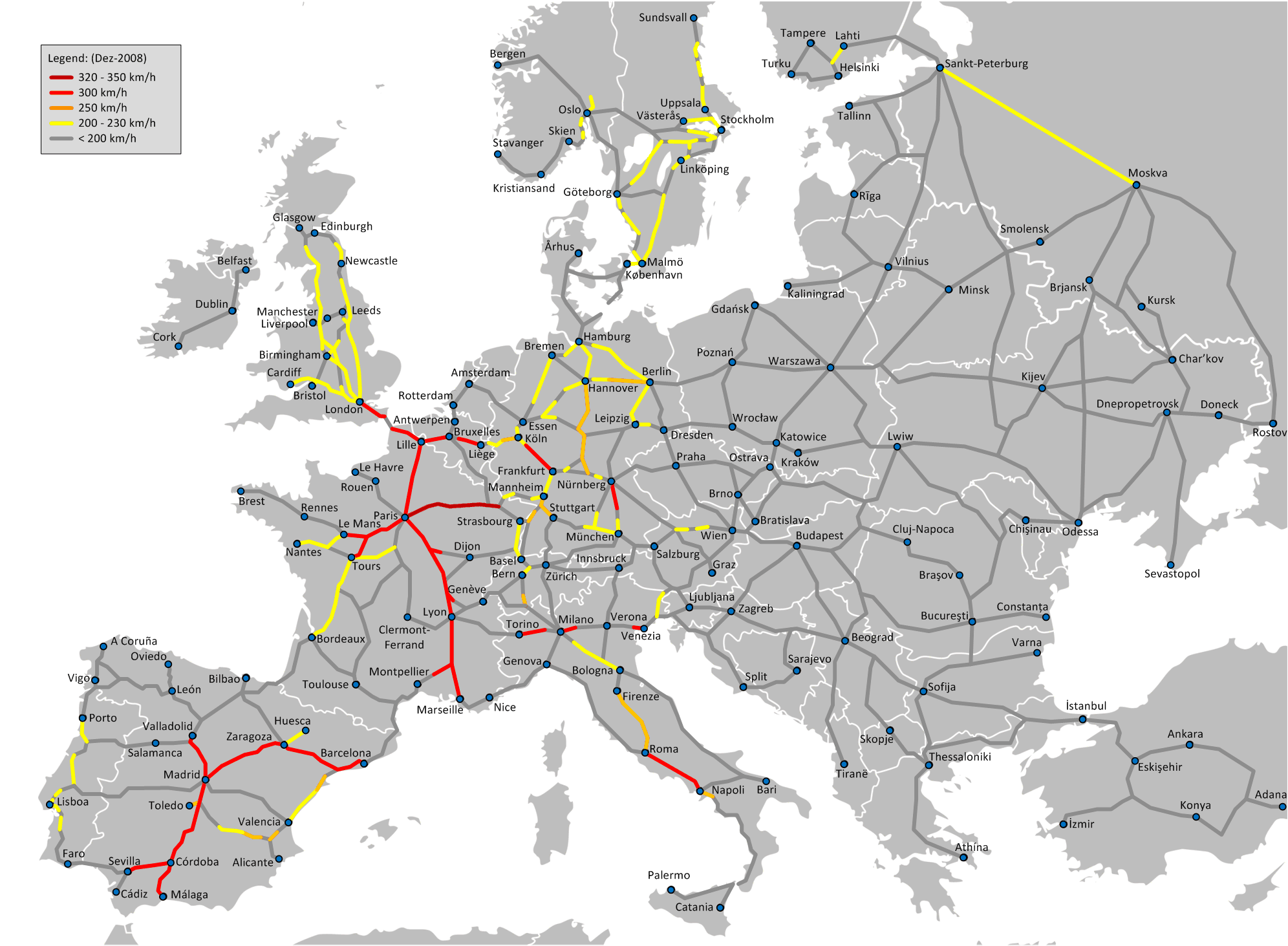
High Speed Rail
It seems sensible to have a tagging scheme for high speed rail that is distinct from ordinary railway lines, and should be rendered as such. In many countries, including France, the systems are entirely distinct from ordinary railways, but we don't seem to have a documented tagging scheme to reflect this. See Wikipedia entry on high speed rail. Daveemtb 14:23, 10 January 2012 (UTC)
- Problem is that they're not always distinct. In many places HSR trains will use ordinary tracks to enter cities, and there's nothing physically preventing ordinary trains from using HSR tracks. The correct ways to distinguish are by tagging electrification and with route relations. --NE2 07:10, 11 January 2012 (UTC)
- How about making use of maxspeed for railways for this purpose? Not that easy to find the data sometimes. As an approximation one can estimate an approximate the maxspeed value from the operating speed for current rail services. In the UK rail schedules are now Open Data which will make that completely legal. I have also just created a new rail speed map using ITO Map that shows tagging of maxspeed on railway lines. Still more work to do on the speed values, which we can discuss on ITO Map ideas. The map is 'clickable' if you are logged in. PeterIto 09:31, 22 June 2012 (BST)
- I like that suggestion. I think speed restriction signs can be visible on the ground for British railways just as for roads. There is also useful info from 2009 here [4] but not sure about the legalities of using this.--Nice but Tim 23:21, 23 June 2012 (BST)
- How about making use of maxspeed for railways for this purpose? Not that easy to find the data sometimes. As an approximation one can estimate an approximate the maxspeed value from the operating speed for current rail services. In the UK rail schedules are now Open Data which will make that completely legal. I have also just created a new rail speed map using ITO Map that shows tagging of maxspeed on railway lines. Still more work to do on the speed values, which we can discuss on ITO Map ideas. The map is 'clickable' if you are logged in. PeterIto 09:31, 22 June 2012 (BST)
Please note that there is an associated conversation taking place on ITO Map ideas in the 'Railway speeds' section. PeterIto 21:43, 24 June 2012 (BST)
railway:historic=xxx or former:railway=xxx in place of railway=abandoned/dismantled?
Should we encourage the use of railway:historic=rail/narrow_gauge/funicular etc in place of railway=abandoned? The main reason to do this is to avoid loosing information about the previous use (railway=abandoned has lost all information about whether it was an abandoned mainline railway or miniature railway which may be important). I found this in use in Cornwall I think and then started using it elsewhere. My only issue is if the order is the wrong way round and if it should be former:railway to be more consistent with 'proposed:railway' and 'construction:railway'. Current usage would be described by appropriate other tags such as highway=cycleway. PeterIto 09:47, 30 June 2012 (BST)
- Not in place of, but perhaps in addition to. Removing railway=* would break existing tools (and make it harder to download current and former railways in an area). --NE2 17:51, 30 June 2012 (BST)
- I agree with NE2 that still having a railway=* tag is useful for extracting data so we would not want to lose that. Don't the gauge=*, tracks=* convey the nature of the line more accurately, and could still be used in conjunction with railway=abandoned or dismantled or disused? --Nice but Tim 18:25, 30 June 2012 (BST)
- I see where you are coming from, especially over consistency with existing tools and retaining use of the current railway=abandoned/dismantled' tags for now as least. Personally I wouldn't want to use the gauge tag for the gauge of a railway that didn't exist any more. gauge:historic would make more sense to me (but I would actually prefer to use the life-cycle prefix tag as I have mentioned above, making it historic:gauge). PeterIto 08:13, 1 July 2012 (BST)
USA Railway Crossing ID
In the USA, the US Department of Transportation has adopted a highway railcrossing inventory program. Unique numbers are assigned to each crossing. They include grade separated, level crossings, and pedestrian crossings. Here is a link to the their website. US DOT National Highway-Rail Crossing Inventory Program. I think that it would be valuable to include nodes with this unique ID on or near crossings. There are lots of bits of information in their database about each crossing, including longitude/latitude, signal type. How do folks think that this should be tagged? Just use a railway=level_crossing, ref= on a node near the crossing? Should it have a special tag so that it is clear that it is in fact a USDOT ID number? Tag the node at the intersection of the highway and the railway? What if there are several tracks or if it is a divided highway; tag each intersections? --Charles_Smothers 18:15, 2 October 2012 (BST)
- After bringing this up at the us-talk mailing list, I believe the way to tag is to use a usdot:ref=ID and to tag each node in the intersection. So if a divided highway crosses three parallel tracks, there are six nodes that are tagged railway=level_crossing usdot:ref=ID. If it is grade separated, it isn't clear what the best way to tag it is. --Charles_Smothers 18:50, 12 November 2012 (UTC)
Train protection systems
Now that most European rail lines are starting to be properly mapped, I think it's time we think about a new feature. How about mapping lines which are equipped with one or more train protection systems ?
I think we can recycle some ideas from the detailed railway network proposal. I have to agree that mapping every signal and every safety beacon is overkill (there are better maps for this, for example the German Railway maps of each station or Betriebsstelle ). But at least a map of specific lines which are equipped with a protection system is much more useful than telling a certain country is using a certain system (like the maps from Bueker here: http://www.bueker.net/trainspotting/voltage_map_europe.php).
The best country to start is Germany, also because most of their main lines are equipped with PZB, and additionally for high-speed running (above 160 km/h), LZB. I suggest we use the same tags as in the proposal. Railway:PZB for PZB90/Indusi, and railway:LZB for LZB. I think this is better than train_protection_system or protection_system, because there could be so many variants if we are going to add more systems. For instance, should lines with ETCS level 1 be tagged with train_protection_system=ETCS1, or ETCS-1, or ETCS_L1 ? If we introduce just one tag railway:ETCS, we limit the available choices to just a single one.
I have already created a proposal page, I would welcome additions or suggestions. --Btrs (talk) 20:31, 7 March 2013 (UTC)
- I don't think that mapping every signal is overkill because there is no such data available free yet. The maps you linked, published by the german railroad infrastructure operator, have some disadvantages:
- * they are not free for use
- * the maps are simplified SVG drawings, but they contain no geographic information to use them as "real" maps
- * they are only for Germany; I do not know if railroad operators in other countries offer similar maps
- * the maps display only single stations, but do not show the complete railroad network
- So they cannot be used by any free project and their quality is also not optimal. Your argument that these maps are better than signals mapped in OpenStreetMap sounds like "Why invent OSM? Google Maps already exists!" for me.
- But that's not the main topic now...
- Concerning the main problem: As I see, your suggestions are equal to the tagging in the OpenRailwayMap schema (currently available only in German), right? Then I would like to link to your proposal, because your listing looks very good and makes it easy to see all the existing systems and the countries in which they are in use. --rurseekatze (talk) 19:18, 21 March 2013 (UTC)
Abandoned Narrow Gauge - how to map?
Hi all,
I'm mapping an abandoned narrow gauge railway but how should I tag this?
'railway=narrow_gauge' + 'gauge=600' + 'abandoned=yes'
or
'railway=abandoned' + 'gauge=600'
or something else? Cheers
-- unsigned comment by user:Abc26324
- Try the following:
- railway=abandoned
- historic:railway=narrow_gauge
- historic:gauge=600
If the line has been re-purposed as footpath and if you know the dates when it opedn as closed etc, then add suitable additional tagging. The following gives the start and end dates and the name for the old railway and also the start date and name for it as a path :
- railway=abandoned
- historic:railway=narrow_gauge
- historic:gauge=600
- historic:start_date=1845
- historic:end_date=1965
- start_date=2003
- old_name=Blar railway
- highway=footway
- name=The old railway path
- etc
- You and check the result using the historic railways map using ITO Map
- Btw some use a shorter prefix "was:"; that is,
was:railway=narrow_gauge(orwas:railway=tramand so on). Can be combined with all former attributes. With railways, and sometimes with other features. Also, I'd userailway:end_date=1965orend_date:railway=1965; there's actually a bridge neaby that will need two "previous" end_date's in the upcoming years; from 1930's to about 2000 it was rail only, then bus only + occasional freight train at night, now it's bus only, and once they build a new tram bridge, it will become a pedestrians and cyclists only bridge. end_date:railway=2012, end_date:unclassified=2018, or something like that. Alv (talk) 08:17, 7 May 2013 (UTC)
When is abandoned no longer even abandoned

Gazing at old maps and photos, I now know for certain that some loading docks at old warehouse buildings are a trace of the railroad spur they used for filling and unloading said warehouse. The building is now a hotel, but the loading docks are in part used for deliveries, and in part for a restaurant terrace. (In the picture to the right, the restaurant is being renovated; the hotel is actually the next building in the background, but this has the easiest-to-identify loading docks remaining.) The sidewalk is right where the tracks used to run. Will that sidewalk be railway=abandoned as long as the building is standing? Why would it then change if the building was torn down (not likely, it's probably protected as "architecturally important")? No other identifying features remain.

Nearby, another old loading dock is still used for deliveries, even if the rails have been removed in the 1950's. Is the abandoned railway "still clearly visible"?

Likewise, there's another old warehouse, but renovated to offices. It has an arcade on one side of the building, tall enough for the cargo trains that used to unload there. The last time they saw a train was probably 50 years ago, or more. The arcade will remain abandoned railway as long as the building is there, but again, what about the sidewalk next to it, which is - as far as anyone can tell - right about where the next track used to be? The buildings next to this (behind the camera, just visible on the far left in the photo), have a slightly curved wall because that's how the track was laid to connect with the other freight rails there. Now is the shape of the wall and the street a sufficient remnant, or not? Anyone can reasonably acquire old maps and identify said street as being where the tracks were.
A third warehouse loading dock still has few meters of rail under the canopy, but at least the rail will be gone when they renovate that whole building to offices; if they leave the former loading bay open, should it still qualify as abandoned? What if they build a glass wall and turn it into an entrance, either by removing the loading dock features altogether, or just add some stairs? Alv (talk) 12:11, 8 May 2013 (UTC)
- I have made some recent suggestions about how to represent historical information relating to Railways. but in this case does not seam to make sense beyond the historical nature of creating a line for this feature. I would suggest for something like this simply
historical=railway. Natfoot_footnat (talk) 2:11, 11 NOV 2013 (UTC)
- Abandoned (or better yet razed/dismantled) railways which no longer have rails, a railway grade, ballast, ties or any other signs of being a railway should not be mapped, because it's not possible to confirm the former location of the tracks based on current real-world objects. See Good_practice#Map_what.27s_on_the_ground and Verifiability --Jeisenbe (talk) 01:15, 4 July 2019 (UTC)
railway=abandoned --> abandoned:railway=....
I dont think using abandoned as a value is very good. For other sturctures and abandoned things you normally just add abandoned: in front of the tag (like abandoned:shop=...). I think thats the way how abandoned railways should be taged too because your dont overwrite the type of the railway . If you have an old tram (railway=tram) thats getting abandoned you would still know that this was a tram(abandoned:railway=tram). This would also make the tagging more consistent. --Hedaja (talk) 10:03, 1 April 2014 (UTC)
Life cycle key prefix to mark abandoned, disused or removed structures
The lifecycle prefix is quite handy to mark structures as either "proposed:", "planned:", in "construction:", "disused:", "abandoned:", "demolished:", "historic:". RicoZ (talk) 21:17, 5 February 2015 (UTC)
railway=stop
I am not a friend of the railway=station central node from the openrailwaymap-scheme contrary to public_transport=station, but it necessary to declare the existence of railway=stop. I would take as first text-version (behind line railway=station) "A station gets only one position with railway=station, the other stop positions get railway=stop" --Axelr (talk) 20:52, 8 February 2015 (UTC)
OK to tag both railway=light_rail AND usage=branch?
In Sonoma and Marin counties in California, a rail line (North Coast Railroad Authority) with freight usage is now tagged railway=rail and usage=branch. Imminently, a portion of this will additionally include passenger service (SMART) as railway=light_rail. On affected rail segments, do I simply change railway=rail to railway=light_rail, leaving the usage=branch tag to indicate the sort of traffic which remains for freight? (These are separated temporally; freight runs at night, passenger/commuter SMART will run in the daytime). Please see the relevant section of California/Railroads for all the gory complexities, but this is the essence of the question I'll have once passenger service starts on SMART very soon.
--stevea (talk) 23:52, 9 October 2016 (UTC)
- Sorry for the late response, I don't observe talk pages at the wiki (but the mailing lists).
- It looks like your describing a tram-train system as it is used in several German cities and the Waterloo Region in Canada. If the track can be or is used by freight trains, it is still a
railway=rail. Therailway=*tag describes the capabilities of the infrastructure. Example: A light rail track is used by a tram and a light rail line and has light rail characteristics (higher average speed, dedicated rights of way/separate trackbed with ballast). You would map it asrailway=light_rail, not as a tram track. The tagging of the routes is not affected. Futher explanation can be found in the discussion on Talk-ca. --Nakaner (talk) 13:15, 15 February 2017 (UTC)
- (Better later than never; thank you for your response!) OK, your example makes sense. However, that's "tram + light_rail" and what I was asking was about light_rail along with usage. And actually, the SMART service will be much more "train" than "light_rail" (it will certainly not be "tram"). So, because these tags are not contradictory and make sense (to me), I think I'll keep the
railway=railtag for the infrastructure (notrailway=light_rail), while leavingusage=branchto indicate the freight/industrial traffic usage and addroute=trainas SMART passenger service begins. --stevea (talk) 14:03, 15 February 2017 (UTC)
- (Better later than never; thank you for your response!) OK, your example makes sense. However, that's "tram + light_rail" and what I was asking was about light_rail along with usage. And actually, the SMART service will be much more "train" than "light_rail" (it will certainly not be "tram"). So, because these tags are not contradictory and make sense (to me), I think I'll keep the
Layer vs level
The template was recently edited to suggest using level=-1 for subways and level=1 for elevated railways. But I believe the normally used key is layer=* --Jeisenbe (talk) 02:43, 31 July 2019 (UTC)
- And level -1 in some situations is strictly wrong - for example subway station on -2 level of shopping mall. But I am unable to find where "suggest using level=-1 for subways and level=1 for elevated railways" was added Mateusz Konieczny (talk) 07:02, 31 July 2019 (UTC)
- Sorry, the changes were in descriptions of tags in Template:Map_Features:railway but I think this is probably the best place to discuss changes to that template. I've removed the mentions of level. --Jeisenbe (talk) 09:01, 31 July 2019 (UTC)
Proposed key:passenger?
There's a proposed tag passenger=urban but the description and definition are inconsistent. I don't think this should be added to the Map Features template yet. See Talk:Tag:passenger=urban for issues. --Jeisenbe (talk) 05:36, 31 July 2019 (UTC)
Should embedded_rails=* be included in the railway template, or just in highway features?
The recently approved tag embedded_rails=* describes if a highway feature has embedded rails which are mapped separately. This is to help out bicycle and motorcycle riders and routers. I was going to add this to the railway features template, but perhaps it only belongs in highways? --Jeisenbe (talk) 05:38, 31 July 2019 (UTC)
Heritage railway naming
How should a railway be named if it is being relaid as a heritage railway?
I have seen the Cambrian Heritage Railway relaying the Whitchurch & Aberystwyth rail line. This being the historic name and would eventually be wiped off the map. The current mapping has the heritage line merging into the Whitchurch & Aberystwyth. As the line is relaid the tags would obviously change.
Should it be: Operator=Cambrian Heritage Railway Name=Whitchurch & Aberystwyth
Or Name=Whitchurch & Aberystwyth; Cambrian Heritage Railway (Or variation thereof?)
Or Should the lines be split into 2 separate elements?
Or something else?
Many thanks for the help Tom W (talk) 15:12, 18 August 2019 (UTC)
- The name tag should be for the current name, which is the neritage railway. You can use the
old_name=*tag for historical names--Andrew (talk) 16:44, 18 August 2019 (UTC)
- It sounds like "relaid lines" are somewhat superfluous as this example of OSM tagging goes: a
railway=railis arailway=rail, whether it is older or brand-new-laid-today. (True, we do make a distinction withrailway=disusedfor usually-older railway which has no or only very occasional use, that is a bit different as it involves whether the line is used / active, disused, or formally abandoned, which usually means the rails and ties are removed, too. There is even one step further I've seen:railway=razed, where the infrastructure was removed so long ago that nature has largely reclaimed the land and there may be only faint — or even no — trace of there ever having been rail there). No, what you are asking is about a soon-to-be- or actually-former railway (W&A), being replaced by a successor railway (CHR), right? CHR happens to be laying new rail as that happens, I assume at the same gauge (if not, usegauge=*). Careful with the upper- vs. lower-case of your tags, you want name=Cambrian Heritage Railway's name for the line, not Name=*. (Same for operator=*).name=*onrailway=railis the name of the LINE, not the name of the operating or owning company (use theoperator=*andowner=*tags, respectively, for those). The point I'm trying to make is that we don't tag rail as its tracks get relaid/renewed, we name the name of the whole line as it is named by its owning rail company (and we put these collected elements into aroute=railwayrelation, you might use aroute=tracksrelation, though that isn't done in USA, I don't know about UK, but "tracks" seems to be used in Germany). And either one "company" or another is the operator (and/or owner), not one-up-to-where-the-old-tracks-are and another-where-the-new-tracks-begin. So find out whether W&A has been "subsumed" and tag therailway=railelements withoperator=Cambrian Heritage Railway(you might also or instead useowner=*here, with the same value),name=the NAME of the 'line,' according to CHRandold_railway_operator=Whitchurch & Aberystwythif it is no longer the active rail operator, having been subsumed by C&R. Yes, as Andrew mentions above, you could useold_name=*if you know W&A's old name of the line. I don't know if this is appropriate in the UK, but in the USA, we addusage=tourismto ways which are "heritage" railways. Yes, that all sounds complicated, but it's not that hard. Stevea (talk) 16:46, 18 August 2019 (UTC)
- It sounds like "relaid lines" are somewhat superfluous as this example of OSM tagging goes: a
- Thank you, I think I follow what you've both said. I have also just seen the Relation option Tag:route=historic and thinking of tagging the whole length from Whitchurch to Aberystwyth as the historic relation, incorporating the Heritage line. Thinking this would satisfy the continuity of the old and the new. Tom W (talk) 21:56, 18 August 2019 (UTC)
Map style KVB and TVM
Hello, On openrailwaymap.org , when I select the map style of the sign, the sign "KVB" and "TVM" do not appear (green color). But in France these are the main signals. I think it is a code error on the site but it is impossible for me to verify it. If someone can verify and solve the problem or knows someone capable of doing so, and if someone knows how to contact an administrator, can you let me know? Thank's !
surface of embedded railway tracks
I have thought about a concept and formulated two proposals. The description is already finished, but examples will follow. See Proposal:Surface_of_embedded_railway_tracks and Proposal:Between_and_beside_rails --TrainTraveller (talk) 16:35, 3 March 2025 (UTC)