ES:Tag:route=ferry
 |
| Descripción |
|---|
| La ruta de un ferry público o autobús acuático. |
| Representación en OSM Carto |

|
| Grupo: rutas |
| Usado en estos elementos |
| Combinaciones útiles |
| Estado: de facto |
| Herramientas para esta etiqueta |
This tag is used on ways which map the route of a ferry or water bus on sea, rivers or other waterways. Ferries are a form of public transport that operate to connect road networks and to provide passenger service much like bus service. Some ferry systems consist of many routes while others are operated just to provide a convenient means to visit an island or to cross a river or lake.
route=ferry can be used for large ferries carrying passengers, bicycles, cars, trucks and even rail cars. It can be used as well as for small boats ferrying people over rivers and lakes or self operated ferries.
How to map
Use the route=ferry tag to show the route of a ferry.
You can either use the tag on a single way ![]() drawn along the whole route. In addition, the tag can also be added to a route relation
drawn along the whole route. In addition, the tag can also be added to a route relation ![]() containing all the ways.
containing all the ways.
How to map using a single way
Draw a way ![]() from one ferry terminal to another and add
from one ferry terminal to another and add route=ferry and name=*.
The ferry route should start and end at a ferry terminal ![]()
amenity=ferry_terminal. At the same point also the access road ends. Between the terminal and the coastal line, there may be a pier ![]()
![]()
man_made=pier which should be tagged with highway=*. Car ferries have often a bridge between the quay wall and the docking point, which is tagged with highway=* + bridge=yes.
The ferry route must not branch in the water, so it must always be drawn to the ferry dock. This is important for routing to work correctly.
Tags
| Key | Value | Comment |
|---|---|---|
| route | ferry |
(mandatory) |
| motor_vehicle | yes / no | Whether the ferry allows motor vehicles (trucks, cars, motorcycles, ...). |
| hgv | yes / no | Whether the ferry allows heavy goods vehicles (freight trucks >3.5 tons). |
| motorcar | yes / no | Whether the ferry allows motorcars. |
| motorcycle | yes / no | Whether the ferry allows motorcycles. |
| bicycle | yes / no | Whether the ferry allows cyclists. |
| foot | yes / no | Whether the ferry allows foot passengers. |
| wheelchair | yes / no | Whether you can board in a wheelchair. |
| motorcycle | yes / no | (mandatory) |
| access | * | For other access restriction tags. Also see Map Features#Restrictions. |
| operator | operator | Name of the company that operates the route. |
| name | individual name | The name of the route or line. |
| ref | reference | The reference number/code of a ferry route. |
| duration | duration | highly recommended for indicating how long the route takes ('00:05' is 5 minutes, '1:15' an hour fifteen, or '48:00' two days). Important to avoid large detours to avoid ferries for routers that underestimate the speed of ferries. OSRM and GraphHopper support this tag (on ways). Use HH:MM:SS, H:MM:SS, HH:MM, H:MM, MM, or M format.
|
| interval | service interval | recommended for indicating how often services run on the ferry route. Use HH:MM:SS, H:MM:SS, HH:MM, H:MM, MM, or M format. Example: A ferry that runs every half hour is given the tag interval=00:30 (interval=30 or interval=00:30:00 are also valid).
|
| fee/toll | yes / no | if you have to pay to cross. Both keys are of very similar popularity, about 500 uses as of 2019[1], see https://lists.openstreetmap.org/pipermail/tagging/2019-June/thread.html#46121 for discussion which tag is preferable |
| opening_hours | opening_hours | when can you expect the service to be active? (only if the ferry operates on a regular schedule) |
| reservation | yes / no / only | yes: reservation / booking possible to avoid long waiting times and/or ensure service will run, no: first come, first serve, only: no passage without a reservation / booking.
|
| ferry | * | for the type of road the ferry route belongs to (used with the same values as highway=*).
|
| ferry:cable | yes | Reaction ferry |
| maxweight | * | Maximum weight of a vehicule. |
| maxlength | * | Maximum length of a vehicule. |
| maxwidth | * | Maximum width of a vehicule. |
| maxheight | * | Maximum height of a vehicule. |
How to map using a relation
The relation approach is a bit more complicated and is not strictly necessary for basic ferry routes represented by a single way, especially when it just crosses a river or canal.
Note that most routing clients and renderers do not currently support ferry relations, so any ferry routes mapped only with relations and not with tags on the individual ways may be unroutable and unrendered at present.
The relation approach is used for some other types of transportation routes which usually span many individual ways, representing many different roads etc. The relation can be a member of a route_master relation. See Relations/Routes.
All the tags and specifications described above for the single way are valid for a relation.
A specific tag must however be added :
| Key | Value | Comment |
|---|---|---|
| type | route |
If you are using a relation, this should always have a 'type' tag, in this case type=route. If the route is on a single way, don't use this tag.
|
| JOSMs validator does currently not work correctly on these routes and marks them as invalid, ways as untagged, etc. See JOSM issue |
Members of the relation
| Way/node | Role | Recurrence? | Discussion |
|---|---|---|---|
| empty | Zero or more | The ways making up the route, in order and connected. In accordance with PTv2, the empty role should be used. These ways should have the tag route=ferry.
| |
| stop | Two or more | Ferry terminals (amenity=ferry_terminal). The order of the members in the relation should be identical to the order in the timetable, and added in order at the beginning of the relation. These nodes should have the tags amenity=ferry_terminal + ferry=yes. They must belong to a way route=ferry member of the relation, and ideally be connected to a road network.
| |
| platform | Zero or more | A pier (man_made=pier) or an area for boarding. The order of the members in the relation should be identical to the order of the stops in the timetable, and added in order with the stops..
|
Related tags
- Proposed_features/Seaway a proposal for all kinds of ports
- Harbour - Describes many tags in and around a harbour/port.
Rendering

Examples
-
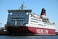 Gros navire de transport de passagers
 -
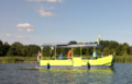 Navire solaire pour cyclistes et piétons
 -
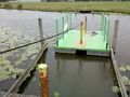 Barge autotractée pour piétons


| ||||||||||||||||||||||||||||||||||||||||||||||||||