Fa:Key:surface
 |
| توضیحات |
|---|
| نوع سطح یک ویژگی را توصیف میکند. |
| گروه: ویژگیها |
| روی این عنصرها بهکار میرود |
| مقادیر مستند: 61 |
| ترکیبات مفید |
| همچنین ببینید |
| وضعیت: دفاکتو |
| ابزارهای مفید برای این برچسب |
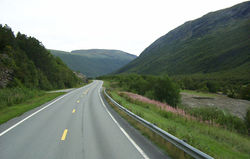
کلید surface برای ارائه اطلاعات تکمیلی در مورد سطح فیزیکی جادهها، مسیرهای پیادهروی و برخی ویژگیهای دیگر، بهویژه در ارتباط با ترکیب مواد و یا ساختار آنها، به کار میرود.
این کلید در ابتدا با تمرکز بر سطح در رابطه با حملونقل و ورزش و بیشتر بر روی ویژگیهای خطی به کار میرفت، اما اکنون بهطور فزایندهای برای برخی نواحی از نوع natural=* نیز استفاده میشود. با این حال، باید توجه داشت که مقادیر natural=* و surface=* نباید با یکدیگر اشتباه گرفته شوند؛ به عنوان مثال، natural=grassland در مقابل surface=grass و natural=glacier در مقابل surface=ice. برای توصیف گستردهتر سطوح، به Landcover مراجعه شود.
مقادیر
سطوح نقشهبرداریشده با OSM را میتوان به سه دسته تقسیم کرد:
همچنین میتوان بر اساس کاربرد، تمایزی قائل شد:
مقادیر پیشفرض
هیچ مقدار پیشفرضی برای سطح وجود ندارد و بهطور کلی، مشخص کردن صریح آن برای همه جادهها مطلوب و قابل قبول تلقی میشود. در صورتی که دادههای surface=* غایب باشند، مصرفکنندگان داده ممکن است گاهی با استناد به موقعیت جغرافیایی شیء و مقادیر highway=*، lit=*، tracktype=*، tiger:reviewed=no و سایر برچسبها، بهطور موفقیتآمیزی مقادیر را حدس بزنند[1][2][3]. تنها در برخی موارد، مانند highway=motorway، میتوان فرض کرد که همه آنها آسفالته هستند.
مصرفکنندگان داده همچنین ممکن است سطوح بدون برچسب را بهصورت ویژه مدیریت کنند (مثلاً نمایش "بدون داده" در فهرست آمار سطوح).
لازم به ذکر است که در برخی مناطق، فرض کردن سطح آسفالته بهعنوان مقدار پیشفرض ممکن است خطرناک باشد.
مقادیر رایج
| Value | Comment | Photo | Abundance |
|---|---|---|---|
↑ ↓
Paved | |||
paved
|
A feature that is predominantly paved; i.e., it is covered with paving stones, concrete or bitumen. This value gives general description; use a more precise value if possible, like asphalt, concrete, paving_stones and other options below.
|

|
|
asphalt
|
Short for asphalt concrete - mineral aggregate bound by asphalt. | 
|
|
chipseal
|
Less expensive alternative to asphalt concrete, using a thin base of hot bitumen or asphalt with aggregate pushed into it. Common in many American countries and Oceania. Often hard to distinguish from asphalt concrete by laypersons, some consider it as subtype of asphalt rather separate surface. In the end vast majority of chipsealed roads are tagged as surface=asphalt instead.
|

|
|
concrete
|
Portland cement concrete, forming a large surface, typically cast in place and may have predetermined breaking joints. For pre-fabricated plates, please use concrete:plates or concrete:lanes if you know how the concrete is laid out and one of these tags fits.
|

|
|
concrete:lanes
|
Long, narrow concrete elements for a two-tracked vehicle (motorcars) so that the tires always hit the concrete. There might be sand, ground, grass, pavers, asphalt, etc. in between them. Note that if you tag a single-tracked way you just use concrete, since there are no lanes. | 
|
|
concrete:plates
|
Large, heavy duty prefabricated concrete plates placed closely together. | 
|
|
paving_stones
|
A relatively smooth surface paved with artificial blocks (block pavers, bricks) or natural stones (specifically, flagstones), with a flat top. The gaps between individual paving stones are very narrow, either because the stones have a perfectly regular shape (rectangular, or any surface-filling shape) or because they have been carefully selected, fitted and placed in order to form an even, closed surface. | 
|
|
paving_stones:lanes
|
lanes of paving stones for two-tracked vehicles (motorcars). There might be sand, ground, grass, pavers, asphalt, etc. in between them. Note that if you tag a single-tracked way you just use paving_stones, since there are no lanes. | 
|
|
grass_paver
|
A sort of permeable paving using regular cell structure, where the voids in this structure enable rainwater to drain into the ground and the structure itself increases the load bearing capability. Often used for parking lots or infrequently used service ways. | 
|
|
sett
|
Sett paving, formed from natural stones cut to have roughly a flat top, with a regular or irregular shape. The stones do not cover the surface completely, unlike paving_stones. They also may be not entirely flat.
|
 
|
|
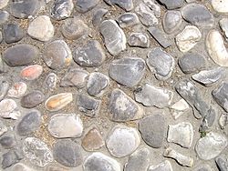
unhewn_cobblestone
|
Raw cobblestone of natural, uncut, rounded stones. Unlike pebblestone, the stones are firmly connected to the ground. | 
|
|
cobblestone
|
cobblestone is an unclear value, and was widely used for sett and actual cobblestone. Please adopt a more precise value, like sett or unhewn_cobblestone (described above).
|
||
cobblestone:flattened |
Should not be used, as there is neither a commonplace or defined meaning. Likely use sett or unhewn_cobblestone instead.
|
||
bricks
|
A surface paved with dried clay bricks. Note that some people use surface=paving_stones for them and treat them as subtype of paving stones.
|

|
|
metal
|
Used for metal-surfaced bridges, or for temporary tracks over fields for normal road vehicles or site traffic (note that objects lasting for just a few days should not be mapped in OSM).
Not used for road metal in the sense of crushed, quarried rock. |
 
|
|
metal_grid
|
Metal grids are often used as a surface on industrial-style bridges or stairs. When wet, the surface can become very slippery, especially for bikes. The surface can also be unsuitable for dogs, due to the sharp edges and the look-through effect. This surface is sometimes known as metal grate, metal grating, steel grate/grating, or open grate. | 
|
|
wood
|
Used for wood surfaced bridges, plank walkways, and garden decking. | 
|
|
stepping_stones
|
Stones or plates individually arranged in a row, allowing to walk on, surrounded by an unpaved medium such as grass or water |  
|
|
rubber
|
Playground safety surfacing made of recycled rubber tire products such as poured rubber, rubber tiles or loose rubber mulch. These surfaces are usually made of rubber designed specifically for aesthetics, child safety, and/or ADA wheelchair accessibility. | 
|
|
tiles
|
Ceramic tiles. Those are commonly used for paving indoor corridors in public spaces such as airports or shopping malls. Outdoors, they are sometimes encountered on smaller footways in parks and terraces. | 
|
|
fibre_reinforced _polymer_grate
|
Oftern used on outdoor walkways, they provide good grip due to the rough surface and open grate allows water to go through the surface. Also known as FRP Grate/Grating. | 
|
|
| user_defined | All commonly used values according to Taginfo. | ||
Unpaved | |||
unpaved
|
A feature that is predominantly unsealed (unpaved); i.e., it has a loose covering ranging from compacted stone chippings to soil. Unpaved roads may, in aerial imagery, show evidence of water along their course; in such circumstances, the waterway should not be tagged as a stream, though it might appear as such. This value gives only a rough description; use a more precise value if possible. | ||
compacted
|
A mixture of larger (e.g., gravel) and smaller (e.g., sand) parts, compacted (e.g., with a roller), so the surface is more stable than loose gravel. Used, for example, for park paths, better tracks, some service ways, … Best sort of ways below paving with asphalt, concrete, paving stones. Sometimes known as water-bound macadam. Mixture and compacting leads to more grip and stability. | 
|
|
fine_gravel
|
This tag is used somewhat inconsistently; see its detail page. It may be used to specify fine loose gravel (as shown in the picture) which makes it unsuitable for road bicycles, but it is also sometimes used as an alias for compacted, which is easy to cycle on. If the gravel is fixed instead of loose, please consider using well-defined compacted instead.
|

|
|
gravel
|
This tag has very large meaning range. Used for cases ranging from huge gravel pieces like track ballast used as surface, through small pieces of gravel to compacted surface. | 
|
|
shells
|
Crushed or whole seashells; commonly seen on footways and cycleways in the Netherlands. | 
|
|
rock
|
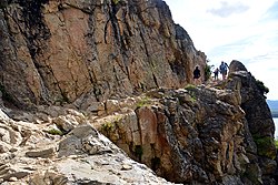
Big pieces of rock used to improve path quality or exposed bare rock, including trails across natural=bare_rock. Typically in mountainous areas.
|
 
|
|
pebblestone
|
Pebbles are stones rounded by waves or river flow. Typical size range from 2 to 8 cm. Describing a surface in OSM they are loosely arranged. Like gravel pebbles can be used as a building part of compacted.
|

|
|
ground
|
No special surface, the ground itself has marks of human or animal usage. This value gives only a rough description; if possible, use a more precise value such as grass, clay, sand, dirt, gravel or pebblestone.
|

|
|
dirt
|
Used for where surface is exposed soil, also commonly referred to as earth or dirt, but it is not sand, gravel, or rock. Gravel is sometimes mistakenly called dirt. Some compacted surfaces are sometimes called "dirt" too, please consider the definition of compacted.
|

|
|
earth
|
The same meaning as dirt. Use the more common dirt instead.
|

|
|
grass
|
Grass covered ground. Mostly nice to walk. May turn into surface=dirt or become overgrown and disappear.
|

|
|
mud
|
Similar to ground but most of the year wet which gives a soft ground with low carrying capacity. Mostly found on wetland like swamps or in tidal areas. Sometimes also found on slopes draining onto a way.
|

|
|
sand
|
Small to very small fractions (less than 2 mm) of rock. | 
|
|
woodchips
|
Woodchips as a surface, perhaps for a playground or walking trail. Can consist of either chips of actual wood, or of bark only. Sometimes written as wood chips. | 
|
|
snow
|
Winter roads surfaced with compacted snow. | 
|
|
ice
|
Ice roads, winter roads | 
|
|
salt
|
Dry salt lakes | 
|
|
| user_defined | All commonly used values according to Taginfo. | ||
Special (sports, etc.) | |||
clay
|
Most common on tennis courts. Sometimes used for other sports: soccer, athletic tracks, boules, etc. | 
|
|
tartan
|
A synthetic, all-weather surface typically used in running and other sport tracks. Although Tartan is a trademark, it is used as a generic term due to its widespread usage. Other well-known brand names include Rekortan or Mondotrack. | 
|
|
artificial_turf
|
An all-weather surface made from synthetic fibres to look and feel like natural grass. Often used for tracks and pitches of sports such as football, baseball, etc. | 
|
|
acrylic
|
An artificial surface covered with acrylic resin-bound coating. Often used for tennis courts, basketball courts, etc. Prominent brands include: DecoTurf, GreenSet and so on. | 
|
|
carpet
|
Carpet may be used for some sport courts such as indoor tennis courts and appear on some highway=corridor.
|

|
|
plastic
|
An artificial surface made from plastic, can be used on pitches and playgrounds. | 
|
|
| user_defined | All commonly used values according to Taginfo. | ||
This table is a wiki template with a default description in English. Editable here.
سطح برای جادههای موتوری

surface=unhewn_cobblestone برچسبگذاری شود - خاصتر از surface=paved برای این سطحبرای جادههای قابل استفاده توسط وسایل نقلیه موتوری، معمولاً فرض بر این است که سطح surface=paved باشد، مگر اینکه خلاف آن مشخص شود. در OpenStreetMap، "آسفالته" بهصورت غیراختصاصی تعریف شده و میتواند شامل سطوح مهر و مومشده، قیر، آسفالت، بیتومن، حتی سنگفرش یا سنگفرش واقعی باشد. surface=unpaved بهعنوان مقابل سطح آسفالته تلقی میشود. برچسبهای خاصتر میتوانند برای سطوحی که معمولاً برای اهداف مسیریابی بهعنوان آسفالته یا غیرآسفالته طبقهبندی میشوند، به کار روند. نرمافزارهای ناوبری باید فرض کنند که جادههای غیرآسفالته دارای سرعت رانندگی کمتر (و در نتیجه زمان رانندگی بیشتر) هستند و ممکن است در برخی شرایط جوی غیرقابل عبور باشند.
برای جادههای آسفالته، استفاده از برچسبهای خاصتر از surface=paved نیز توصیه میشود؛ به عنوان مثال surface=asphalt.
smoothness=* نیز یک ویژگی مهم سطح بوده و به regularity/flatness سطح، صرفنظر از جنس مواد، اشاره دارد. این ویژگی میتواند بهویژه برای اسکیتسواری و اهداف مشابه مفید باشد.
tracktype=* نیز یک ویژگی مهم سطح بوده و به استحکام سطح، صرفنظر از شکل آن، اشاره دارد.
مسیرهای highway=* بهطور ایدهآل باید همیشه با برچسب سطح (و یا با tracktype=*) مشخص شوند، زیرا برای این مسیرها مقدار پیشفرض وجود ندارد.
کنوانسیون نرمافزارهای رندرینگ متفاوت است، اما بهطور کلی، جادههای غیرآسفالته معمولاً با رنگ متفاوتی اما با همان عرض جادههای آسفالته نمایش داده میشوند یا با همان رنگ اما بهصورت خطچین نشان داده میشوند. Rendering of road surface in standard OSM style موضوعی پیچیده است.
در برخی موارد که برچسبهای دیگر برای توصیف شرایط جاده کافی نباشند، استفاده از smoothness=* و maxspeed:practical=* قابل بررسی است. maxspeed:practical=* میتواند در موقعیتهایی که برچسبهای دیگر برای توصیف سرعت قابل انتظار کافی نیستند، مفید باشد. اگر جادهای با سطح غیرآسفالته با سرعت عملی ۶۰ کیلومتر بر ساعت و جادهای دیگر با سطح بتن:lanes با سرعت عملی ۱۰ کیلومتر بر ساعت وجود داشته باشد، کاربران یا نرمافزارهای مسیریابی ممکن است به اشتباه جاده دوم را برای مسیریابی انتخاب کنند، زیرا بهطور پیشفرض فرض بر این است که جادههای آسفالته سرعتهای بسیار بالاتری نسبت به جادههای غیرآسفالته دارند.
سطح برای مسیرهای پیادهروی و دوچرخهسواری

cycleway:surface=asphalt و footway:surface=paving_stones برای مشخص کردن سطح دارداگر مسیر پیادهروی یا دوچرخهسواری بهعنوان برچسب (نه بهصورت مسیر جداگانه) بر روی یک جاده (یعنی highway=secondary + cycleway=track/lane) مشخص شده باشد، میتوانید سطح را با استفاده از سینتکس زیر اضافه کنید:
یا بهصورت خاصتر:
sidewalk:both:surface=*sidewalk:left:surface=*(سمت چپ بسته به جهت مسیر)sidewalk:right:surface=*(سمت راست بسته به جهت مسیر)
یا اگر مسیر پیادهروی یا دوچرخهسواری تنها در یک طرف خیابان وجود داشته باشد، یا سطوح دو طرف متفاوت باشند، میتوانید از سمت راست و چپ (یا هر دو، برای مشخص کردن هر دو طرف بهصورت صریح) استفاده کنید:
برای نمونههای بیشتر، به cycleway:right=* / cycleway:left=* / cycleway:both=* مراجعه شود.
با این سینتکس، میتوانید سایر برچسبهای مرتبط مانند: smoothness=*، oneway=*، bicycle=*، foot=*، width=*، segregated=* و موارد دیگر را نیز اضافه کنید.
در صورتی که مسیر ترکیبی جداگانه دوچرخهسواری و پیادهروی بهصورت یک خط واحد برچسبگذاری شده باشد و هر کدام دارای مقدار جداگانهای باشند، میتوان از footway:surface=* + cycleway:surface=* استفاده کرد.
کاربردها
کاربرد اصلی، مسیریابی است. مسیریاب دوچرخهها میتواند از جادهای که بهعنوان دارای سطح ماسهای (surface=sand) برچسبگذاری شده اجتناب کند. برای وسایل نقلیه، مسیریاب ممکن است با ترجیح مسیر کمی طولانیتر با سطح آسفالت بر مسیرهای خاکی/فشرده/شنریزه/سنگفرش، تصمیمگیری کند. عابران پیاده نیز احتمالاً هر سطح آسفالته را بر مسیرهای بالقوه گلآلود ترجیح میدهند. این برچسب همچنین میتواند برای استفاده از بافت مناسب در رندرینگ به کار رود، به عنوان مثال برای نشان دادن مسیرهای غیرآسفالته.
OsmAnd صافی و سطح را نمایش میدهد، اگر در منو فعال شده باشد (Configure map - Details). اینجا کلید نقشه با رندرینگ برای هر مقدار صافی و سطح موجود است.
ابزارهای احتملاً مفید
همچنین ببینید
material=*- توصیف جنس اصلی یک ویژگی فیزیکیsmoothness=*- مشخص کردن قابلیت استفاده فیزیکی یک مسیر برای وسایل نقلیه چرخدار به دلیل regularity/flatness سطحtracktype=*- ارائه طبقهبندی مسیرهاsurface:colour=*- توصیف رنگ سطح (در صورتی که قابل استنباط نباشد)، مطابق با راهنمایcolour=*surface:grade=*- برچسب کمتعیینشده برای رتبهبندی کیفیت سطح با کد عددی، به جای آن ازsmoothness=*استفاده شودsurface:middle=*- توصیف سطح میانی مسیر در صورتی که با بخشهایی که ردیف چرخها روی آن قرار دارد متفاوت باشدsurface:lanes=*- برای توصیف سطوح موازی متعدد در یک مسیر (مثلاً مسیر دوچرخهسواری/پیادهروی با دو سطح متمایز)- Landcover
- Proposed features/Surface:all weather، پیشنهادی برای سلسلهمراتب مقادیر و مقدار all_weather
- Seamarks/General Attributes#Nature of surface (NATSUR)
- سبک رندرینگ (بسیار ناهموار، ناقص) با استفاده از OverpassTurbo
- پرسوجو برای یافتن مقادیر سطح استفادهشده در OSM که در این صفحه مستند نشدهاند با استفاده از OverpassTurbo
نقشههای نمایشدهنده دادههای سطح
- https://graphhopper.com/maps/ – پس از تعیین مسیر، سطح را میتوان در نمودار پایین با تغییر به 'surface' مشاهده کرد.
- OsmAnd - نقشه برداری پیشفرض برداری آن دارای گزینهای برای نمایش سطح جاده است، و اگر مسیر ناوبری محاسبه شود، سطوح جمعآوری شده و در جزئیات مسیر نمایش داده میشود.
- StreetComplete - پس از فعالسازی پوشش سطح
اشتباهات احتمالی در برچسبگذاری
منابع
- ↑ https://lists.openstreetmap.org/pipermail/tagging/2019-September/048330.html
- ↑ https://lists.openstreetmap.org/pipermail/tagging/2019-September/048338.html
- ↑ https://lists.openstreetmap.org/pipermail/tagging/2019-September/048355.html "در نهایت، در جایی که اطلاعات غایب است، شما بهعنوان مصرفکننده داده باید تصمیم بگیرید که آیا جاده احتمالاً آسفالته است یا خیر. افزودن یک مقدار پیشفرض (حتی برای هر کشور) بهصورت جادویی همه جادههای بدون برچسب سطح را آسفالته یا غیرآسفالته نمیکند."