Ohio/Map features
This page is a supplement to Map Features that describes how to map in Ohio. Whereas Map Features and other pages in the Key: and Tag: namespaces of this wiki offer general advice that applies globally, this page describes tagging conventions that are peculiar to Ohio in OpenStreetMap and offers examples that are familiar to Ohio residents.
The suggestions on this page are the product of many discussions among Ohio mappers dating back to around 2009. In some cases, they reflect practices that have not been formally discussed but that are nonetheless widespread in Ohio. If any of these practices need to be updated, please discuss and coordinate changes with other Ohio mappers to ensure consistency across the state.
Names
In Ohio, names are assumed to be in English by default. If a road, POI, or other feature is named in a language other than English, also indicate its language using the appropriate language subkey. For example, a Mexican restaurant named "El Picante" would be tagged name=El Picante name:es=El Picante. On the other hand, the village of Cadiz can be tagged just name=Cadiz without name:es=*, because the name has been borrowed from Spanish rather than being signposted in Spanish. Similarly, a restaurant named "Kremer’s" can be tagged name=Kremer’s without name:de=* or name:nl=*. (These are also good examples where name:pronunciation=* and name:etymology=* would be helpful.) Names in Pennsylvania German (Pennsylvania Dutch) are tagged name:pdc=*.
Some mappers prefer to use ASCII punctuation ('"-) for convenience, while others prefer to use curly apostrophes and other typographically correct punctuation (“”‘’–). Punctuation is valid in street names according to the "on the ground" rule. TIGER has no way to represent any punctuation, even where required, so if you are using the TIGER Roads layer, avoid overriding detail that others have added.
Roadways
Road classifications
Road classifications on surface streets are based primarily on connectivity, not the road's width or speed limit. These guidelines are intended to produce a map well-suited to the state's urban centers and suburbs, the rural farmlands and small towns across the northwest and Amish Country, and the more rugged areas in the southeast.
highway=motorway
Interstate highways, including loops and spurs, as well as significant portions of U.S. and state routes that have been upgraded to Interstate standards (high-speed, divided, fully access-controlled).
- highway=motorway
-
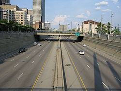 Fort Washington Way (I-71/US 50) in Downtown Cincinnati
 -
 Mill Creek Expressway (I-75) through Lockland
 -
 Ohio Turnpike (I-80) through Cuyahoga Valley National Park
 -
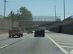
 State Route 7 in Knox Township, Jefferson County
 -
 Ronald Reagan Cross County Highway (SR 126) near Blue Ash
 -
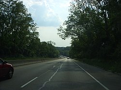
 U.S. Route 33 in Logan County


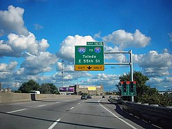
highway=trunk
Select U.S. and state routes not built to Interstate standards. High-speed, limited-access, usually divided highways with at least two lanes in each direction. May have occasional traffic lights and unlit street-level crossings, but mostly controlled-access with on- and off-ramps. A two-lane, undivided (but still limited-access) road segment may qualify as highway=trunk if it is an extension of a divided trunk road or motorway. These roads can also be tagged expressway=yes to reinforce the limited-access nature of these roads (since highway=trunk is defined differently in some countries).
- highway=trunk
-
 Appalachian Highway (US 50/SR 32) in Carthage Township, Athens County
 -
 Columbia Parkway (US 50) on the east side of Cincinnati
 -
 Western Hills Viaduct on the west side of Cincinnati


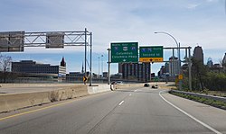
highway=primary
Other U.S. routes; major state routes, such as those that connect larger county seats not directly connected by US routes, or are important connectors between primary or higher roads. An example of which routes might be promoted to primary can be found here. Sections of primary roads normally should not "dead-end" at lower-class roads. Be sure to add the road to a route relation if applicable.
- highway=primary
-
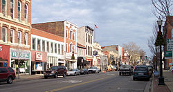
 Lincoln Way at 1st Street in Massillon
 -
 U.S. Route 22 in Lancaster
 -
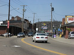
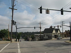
 South State Street (SR 4) in Marion
 -
 U.S. Route 40 in Bridgeport
 -
 U.S. Route 22 in Jasper Mills
 -
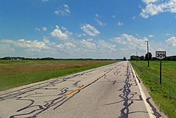 State Route 309 at the Marion–Hardin county line


.jpg)


highway=secondary
Other state routes; good connecting roads, such as those that connect cities not directly connected by state routes, or are important connectors between secondary or higher roads. Sections of secondary roads generally should not "dead-end" at lower-class roads. Be sure to add the road to a route relation if applicable.
- highway=secondary
-
 State Route 123 in Lebanon
 -
 State Route 125 in Lynx
 -
 State Route 125 in West Union
 -
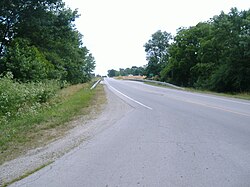
 Main Street (State Route 103) in downtown Bluffton
 -
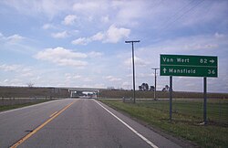 State Route 231 at U.S. Route 30 near Nevada


highway=tertiary
County routes (signposted or otherwise) and other major local roads, typically along section lines or connecting towns. Also former state route alignments and major streets in central business districts. Consider adding the road to a route relation if applicable.
- highway=tertiary
-
 County Road 851 in Monroe Township, Guernsey County
 -
 North Lewisburg Road in Allen Township, Union County
 -
 Logan County Road 5 (Old State Route 533) at State Route 540 in New Jerusalem
 -
 County Road 111 in Rushcreek Township, Logan County
 -
 5th Street in Downtown Cincinnati
 -
 Camargo and Miami Roads in Madeira
 -
 Lower Twin Road (C-54) at the South Salem Covered Bridge in South Salem


highway=unclassified
Major township roads (signposted or otherwise). Rural roads, serving mostly farmland or forest properties, of little to no value as through routes. Consider adding the road to a route relation if applicable.
- highway=unclassified
-
 Campbell Road in Marion Township, Marion County
 -
 Bennett Schoolhouse Road at Harrison Mills in Harrison Township, Scioto County
.jpg)

highway=residential
City or neighborhood streets not qualifying as tertiary or higher, or rural roads which have become lined with houses on both sides.
- highway=residential
-
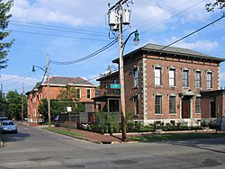 3rd and Beck streets in German Village, Columbus
 -
 Germantown Road in Germantown
 -
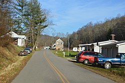
 Kittle Road in Vernon Township, Scioto County
 -
 Brampton Abbey near Zoar in Hamilton Township, Warren County
 -
 Addison Avenue in the St. Clair–Superior neighborhood of Cleveland


highway=service
Use service=driveway for private driveways that lead directly to residences, as well as driveways that are used primarily for pickup and drop-off (as opposed to parking) at a business, church, or school. Do not use service=driveway for shared driveways.
Use service=emergency_access for fire access lanes leading to gated communities, as well as emergency crossovers on divided highways. Also use access=no and emergency=designated, for good measure.
Numbered routes
Route numbers are indicated both by the ref=* tag on the roadway and by the network=* and ref=* tags on the route relation that contains the roadway.
| Marker | Remarks | |||
|---|---|---|---|---|
| Reassurance | Guide sign | |||
| Nationwide route marker designs | ||||
 |
ref=I 80 |
network=US:Iref=80 |
Interstate highways. | |
 |
.svg) |
ref=US 50 |
network=US:USref=50 |
U.S. routes. |
| Statewide route marker designs | ||||
 |
.svg) |
ref=SR 2 |
network=US:OHref=2 |
State routes. Do not use OH ### or US:OH ###. (Map renderers can distinguish Ohio state routes from other states' routes using route relations or by employing spatial queries.)
|
 |
network=US:OH |
The Ohio Turnpike. | ||
| Some common county route marker designs | ||||
 |
ref=CR 22A |
network=US:OH:JEFref=22A |
The ref=* tag probably should only be used if the county route number is signed as clearly as on a state route; otherwise, consider using unsigned_ref=* or loc_ref=* instead. The TIGER data often includes name_1=County Highway xx in counties that signpost county routes. Note that, in some northwestern counties, it’s perfectly valid for a county road number to be a fractional number (using either a period or hyphen).
Consider adding the road to a route relation if applicable. The | |
 |
ref=C-28 |
network=US:OH:LOGref=28
| ||
 |
ref=C-35 |
network=US:OH:GUEref=35
| ||
ref=CH 16 |
network=US:OH:PREref=16
| |||
ref=Co 47 |
network=US:OH:FAYref=47
| |||
| Some common township route marker designs | ||||
 |
ref=T-190 |
network=US:OH:LOG:Monroeref=190 |
Township routes. The ref=* tag should only be used if the township route number is signed as clearly as on a state route; otherwise, consider using unsigned_ref=* or loc_ref=* instead. Note that, in some northwestern counties, it’s perfectly valid for a township road number to be a fractional number (using either a period or hyphen).
Consider adding the road to a route relation if applicable. The | |
 |
ref=TR 256 |
network=US:OH:MRW:Benningtonref=256
| ||
| City route marker designs | ||||
ref=Cty Rt 53 |
network=US:OH:SAN:Fremontref=53 |
City routes in Fremont. | ||
Speed limits
Speed limits in OSM interpreted as kilometers per hour by default, so speed limits in the U.S. must be explicitly labeled as miles per hour:
maxspeed=25 mph
Remember to use a space and lowercase the "mph" abbreviation.
Only tag maxspeed=*, maxspeed:advisory=*, and minspeed=* based on signs or pavement markings. Do not assume, for instance, that an expressway has a higher speed limit than a two-lane rural road. The flowchart below gives an idea of where you can expect to see certain speed limits on public roads in Ohio, per ORC 4511.21§B:

Many private driveways and parking lot aisles have posted speed limits of 5–10 mph.
A school zone's 20 mph speed limit can be tagged if the school's drop-off, recess, and pickup times are known. For example, a high school's school zone might be tagged maxspeed:conditional=20 mph @ (Mo-Fr 07:45-15:30, SH off). See the Conditional restrictions and opening_hours=* documentation for details on the syntax for specifying times. If a sign lights up when the school zone is in effect, as indicated by a ![]() "When Flashing" sign, also use
"When Flashing" sign, also use maxspeed:variable=school_zone. However, if all the sign says is "During Restricted Hours" and the school's hours are unknown, then use maxspeed:conditional=20 mph @ "restricted hours". Extend the any school zone–related tags up to the ![]() sign.
sign.
Use the maxspeed:advisory=* tag for yellow ![]() advisory speed limit signs on highway ramps, along curved sections of roadway, or near dangerous rural intersections.
advisory speed limit signs on highway ramps, along curved sections of roadway, or near dangerous rural intersections.
Weight restrictions
-

maxweight=10 stmaxweight:hgv:conditional=10 st @ (axles=2); 14 st @ (axles=3); 18 st @ (axles=4); 22 st @ (axles=5); 24 st @ (axles>=6)maxweight:hgv_articulated=40 st
(specify unit as short tons) -

maxweight:emergency=25 stmaxweight:emergency:conditional=25 st @ (axles=2); 40 st @ (axles>=3)
(specify unit as short tons) -

-

maxweight:conditional=12 st @ (Feb 1-May 15)maxweight:hgv:conditional=12 st @ (Feb 1-May 15 AND axles=2); 36800 lbs @ (Feb 1-May 15 AND axles=3); 43200 lbs @ (Feb 1-May 15 AND axles=4); 32 st @ (Feb 1-May 15 AND axles=5); 55600 lbs @ (Feb 1-May 15 AND axles=6); 31 st @ (Feb 1-May 15 AND axles>=7)maxweight:hgv_articulated:conditional=32 st @ (Feb 1-May 15)
(80% of legal load limits for configurations 2F1, 3F1, 4F1/SU4, SU5, SU6, SU7, and 5C1, respectively)


To tag a "Weight Limits Reduced" sign, reduce the legal limits in the table below by the percentage on the sign:
| Configuration | Axles | Articulated | Unreduced legal limit |
|---|---|---|---|
| 2F1 | 2 | no | 15 short tons (14 t) |
| 3F1 | 3 | no | 23 short tons (21 t) |
| 4F1 | 4 | no | 27 short tons (24 t) |
| SU4 | 4 | no | 27 short tons (24 t) |
| SU5 | 5 | no | 31 short tons (28 t) |
| SU6 | 6 | no | 34 3⁄4 short tons (31.5 t) |
| SU7 | 7 | no | 38 3⁄4 short tons (35.2 t) |
| 5C1 | 5 | yes | 40 short tons (36 t) |
Highway entrances and exits
Exit numbers are tagged in two places: on highway=motorway_junction nodes using the ref=* tag and on highway=motorway_link or highway=trunk_link ways using the junction:ref=* tag.
Route markers on entrance and exit guide signs are tagged on highway=motorway_link or highway=trunk_link ways using the destination:ref=* and destination:ref:to=* tags. The tag values should match the ref=* tags of the ways that the guide signs refer to, as listed in "Numbered routes". Note that Ohio state routes have the prefix SR, not OH.
Road names and place names on entrance and exit guide signs are tagged on highway=motorway_link or highway=trunk_link ways using the destination=* tag. Do not use the deprecated exit_to=* tag on highway=motorway_junction nodes. Road names should match the name=* tags on the roadways that the guide signs refer to. Mappers in Cincinnati should be aware of the supplemental road names that appear beside route markers on guide signs in Kentucky (but not in Ohio): these road names go in the destination:street=* tag.
-
 Left:
Left:destination:ref=I 71 North;US 50 Eastdestination:ref:to=I 471destination=Columbus;Columbia Parkway
Right:destination:ref=I 71 South;I 75 Southdestination=2nd Streetmaxspeed:advisory=35 mph -

-
-
.jpg)


Complex junctions
Here are some examples to follow if you encounter a complex junction.
Single-point urban interchange (SPUI) above I-75 at the SR 63 exit in Monroe, 1843583![]() 1843583:
1843583:

Continuous-flow intersection (CFI) between Beechmont Avenue (SR 125) and Five Mile Road in Anderson Township, Hamilton County:

Diverging diamond interchange (DDI) above I-475/US 23 at the US 25 exit in Perrysburg:

Superstreet intersection between SR 4 Bypass and Hamilton Mason Road in Fairfield:

Multilane roundabout at Eastgate South Drive and Clepper Drive in Union Township, Clermont County, 8126820![]() 8126820:
8126820:

Bikeways
| Tag | Description |
|---|---|
highway=cycleway foot=designated |
Bike trail or multiuse trail |
highway=* cycleway=lane |
Bike lane |
Along the Ohio-to-Erie Trail, some segments are also open to horseback riding; tag these segments with horse=designated.
Numbered routes
| Marker | Remarks | ||
|---|---|---|---|
ncn_ref=50 |
network=ncncycle_network=US:USref=50 |
U.S. Bicycle Routes. | |
rcn_ref=1 |
network=rcncycle_network=US:OHref=1 |
Numbered state bike routes. | |
rcn_ref=A |
network=rcncycle_network=US:OHref=A |
Lettered state bike routes. |
Street furniture
Road signs
Road signs are tagged with traffic_sign=*; most values start with US:, followed by standard sign code, but Ohio-specific signs start with US:OH:. MUTCD/Ohio lists each sign code in the Ohio MUTCD and its equivalent tags.
Public transportation
Ohio/Route relations/Public transportation lists the major public transportation systems (bus, rail, etc.) that serve Ohio, along with the route=*, network=*, and/or operator=* tags commonly used for route relations belonging to those systems.
Use the busway=yes tag for dedicated bus rapid transit roadways that are physically separated from other traffic. Use the busway=lane tag for dedicated bus lanes.
Land use
Land use areas are useful for giving the map more structure than administrative boundaries alone. Land use in OpenStreetMap is not necessarily about zoning. Though these areas often generally correspond to zoning areas, the subjective character of the neighborhood is a more significant factor for choosing a landuse=* tag. For example, a landuse=industrial area covers a large swath of the Mill Creek Valley north of Cincinnati, befitting the area's heavy industrial character (click through to see the landuse areas):

As an area gets mapped in greater detail, these informal land use areas give way to more verifiable land use areas that indicate the formal boundaries of planned developments. For example, Deerfield Township in Warren County is neatly subdivided into many residential, retail, and commercial complexes – plus a few farms – each with names reflecting prominent signage. It is much easier to browse the map now that the land use areas have been drawn in (click through to see the landuse areas):

When you draw a formal, planned land use area, you should try to follow the property boundaries. (It’s OK for a land use area to overlap a land cover area like natural=wood.) For example, a residential subdivision may go right down the middle of a tree row that separates it from another residential subdivision, or the subdivision may include wooded lots.
Originally, the consensus among local mappers used to be that formal land use areas should be connected to roads, based in part on the fact that property lines often follow road centerlines. In November 2020, Ohio mappers decided to discontinue this practice to make it easier to edit roads. [1] Land use areas are gradually being disconnected from roads. However, they should continue to be connected to riverbanks and administrative boundaries as applicable, for example when both a formal land use area and a boundary intentionally follow the same property line.
| Tag | Description | Examples | |
|---|---|---|---|
landuse=residential
|
Residential areas, like subdivisions. Useful for getting subdivision names on the map. | ||
Leisure
| Tag | Description | Examples | |
|---|---|---|---|
leisure=park
|
City and county parks, plus county fairgrounds. | ||
leisure=nature_reserve
|
Nature preserves maintained by local or state agencies or by private organizations. Many state parks are best thought of as nature preserves. | ||
tourism=attraction attraction=maze
|
Corn mazes. | ||
building=grandstand amenity=bench |
Bleachers at outdoor athletic fields (football, soccer, baseball, etc.) | ||
Food
iD includes presets for the larger regional food service chains in Ohio via the name suggestion index. Here are some Ohio chains that have not been added to the index yet:
| Name | amenity=* or shop=* |
cuisine=* |
Other tags | Notes |
|---|---|---|---|---|
| B&K Rootbeer | amenity=restaurant |
cuisine=burger |
drive_in=yes
| |
| Cassano's Pizza King | amenity=restaurant |
cuisine=pizza
|
When mapping a United Dairy Farmers location, map the store as amenity=ice_cream shop=convenience cuisine=ice_cream, and map the gas canopy out front as amenity=fuel.
A pony keg should be tagged either shop=convenience alcohol=yes or shop=alcohol, depending on whether it sells items other than beer and wine. lottery=yes may also be appropriate.
History
Buildings on the National Register of Historic Places should be tagged:
historic=heritageheritage=2heritage:operator=nrhpheritage:ref=NRIS IDref:nrhp=NRIS ID
Bridges (man_made=bridge) in ODOT's Ohio Historic Bridge Inventory should be tagged:
historic=heritageheritage=4heritage:operator=odot
Ohio History Connection historical markers should be tagged:
historic=memorialmemorial=plaquesupport=postsubject=history(or something more specific)operator=Ohio History Connectionoperator:wikidata=Q3349886network=Remarkable Ohionetwork:wikidata=Q111467380ref=Marker#-County#
Similarly, Ohio History Connection's Corporate Limit Markers should be tagged:
historic=memorialmemorial=plaquesupport=postoperator=Ohio History Connectionnetwork=Ohio Corporate Limit Markerssubject=Name of municipality
The Ohio Historic Inventory, maintained by the State Historic Preservation Office, does not confer protection on historic structures, so it does not qualify structures for historic=heritage tagging on its own, though some structures on the inventory may also be on the NRHP or a local register. [2]
Places
place=* POIs identify population centers. Where these population centers happen to correspond to municipal corporations, they are additionally mapped as boundary relations; the place=* POI is added to the boundary=administrative relation with a role of label. Put the place=* POI at the location that is generally considered the center of the place, for example, a town square, a county courthouse, or the intersection that serves as the origin of a city's street grid.
| Tag | Description |
|---|---|
place=city |
Cities at the center of metropolitan areas, generally with a metropolitan population above 100,000. |
place=town |
Medium-sized cities, including suburbs, generally with a population between 10,000 and 100,000 within corporation limits. Some cities with a population less than 10,000 are also tagged place=town if they are county seats. There are some place=town POIs representing population centers within unincorporated areas. These POIs may lie within census-designated places (CDPs) but do not necessarily correspond to them.
|
place=village |
Small cities with a population less than 10,000, as well as villages (with a population less than 5,000). There are some place=village POIs representing population centers within unincorporated areas, such as former villages that have disbanded.
|
place=suburb |
Neighborhood districts within cities that are tagged place=city. Often, these districts are historically separate cities that were annexed by the current city. When these districts are well-defined, they are also mapped as boundary relations with admin_level=10.
|
place=neighbourhood |
Neighborhoods (note the British spelling) within cities tagged place=town or within larger neighborhood districts tagged place=suburb. When these neighborhoods are well-defined, they may also be mapped as land use areas.
|
Boundaries
- Main article: Ohio/Boundaries
| Tag | Description |
|---|---|
boundary=administrative admin_level=4 |
Ohio state line; see Ohio River for nuances regarding that border. |
boundary=administrative admin_level=6 |
County line. |
boundary=administrative admin_level=7 |
Township line, excluding any city or village that has withdrawn from the township. |
boundary=administrative admin_level=8 |
Corporation limit of a city or village. May cross county and township lines. May be exclusive of any township. A city or village may own land outside the corporation limit, usually a park or airfield. Do not include this land in the boundary; instead, use the operator=* tag to indicate ownership.
|
boundary=administrative admin_level=10 |
Well-defined, officially recognized neighborhood boundary in one of the largest cities (Akron, Cincinnati, Cleveland, Dayton, Toledo). Note that Columbus has poorly defined neighborhoods that should be mapped as POIs but not as boundaries. |
boundary=census |
Census-designated place. |
Miscellany
Especially in Amish Country, roads and bike paths with ![]()
![]() or
or ![]() warning signs should be tagged
warning signs should be tagged carriage=designated. Crossing nodes and ways are also tagged carriage=designated based on ![]() signs. Hitching posts can be tagged
signs. Hitching posts can be tagged amenity=hitching_post.
Golf cart paths within golf courses and ![]() golf cart crossings are tagged
golf cart crossings are tagged golf_cart=designated. Note that golf carts that meet roadworthiness requirements are also allowed on Ohio streets with speed limits up to 35 mph (essentially, anything other than a freeway, expressway, or U.S. or state route). There hasn't been a concerted effort to tag residential and downtown streets with golf_cart=yes, but that isn't out of the question.
When mapping individual traffic signs, follow the format traffic_sign=US:X-1 or traffic_sign=US:OH:Y-1, where X-1 is the sign code found in the national Manual on Uniform Traffic Control Devices and Y-1 is the sign code of a sign found only in the Ohio MUTCD. Refer to the Ohio MUTCD sign index for all sign codes applicable in Ohio.
See also
- ↑ Manual of Bridge Inspection (PDF) (v.8 ed.). Ohio Department of Transportation. 2014 [1973]. p. 40.
- ↑ Waheed, Amjad (August 18, 2016). “Special Hauling Vehicles (SHV) Load Rating Update” (PDF). County Engineers Association of Ohio. p. 15.
- ↑ “Implementation of Special Hauling Vehicles in the ODOT Load Rating Process” (PDF). County Engineers Association of Ohio. March 10, 2020. pp. 7–8.