Pl:Key:natural
Jump to navigation
Jump to search
 |
| Opis |
|---|
| Opisuje naturalne fizyczne obiekty lądowe, w tym te zmodyfikowane przez człowieka. |
| Grupa: Środowisko naturalne |
| Używane na tych elementach |
| Udokumentowane wartości: 93 |
| Status: de facto |
| Narzędzia |
natural=* – stosowany do oznaczania naturalnych obiektów geograficznych, geologicznych i lądowych, również tych zmodyfikowanych lub utworzonych przez człowieka.
Wartości
Środowisko naturalne (Natural)
Tagi stosowane do oznaczenia naturalnych obiektów środowiska naturalnego.
| Klucz | Wartość | Element | Opis | Rendering | Zdjęcie |
|---|---|---|---|---|---|
Roślinność lub pokrewne | |||||
| natural | fell | Hala górska, kamienista łąka pokryta trawą. Często z wypasem zwierząt. | No, see #545. |  | |
| natural | grassland | Gdzie dominuje roślinność trawiasta (Poaceae) i inne zielne (nie zdrewniałe) rośliny, z wyjątkiem ozdobnych traw (zob. landuse=grass) i pastwiska (zob. landuse=meadow)
|
 |
 | |
| natural | heath | Wrzosowisko. Nisko położony dziki teren z krzewinkami, nie występują drzewa. |  |
 | |
| natural | moor | Don't use, see wikipage. Upland areas, characterised by low-growing vegetation on acidic soils. | currently not rendered by OSM Carto |  | |
| natural | scrub | Busz, scrub. Dziki teren z krzakami i niskimi drzewami. |  |
 | |
| natural | shrubbery | An area of shrubbery that is actively maintained or pruned by humans. A slightly wilder look is also possible | currently not rendered by OSM Carto |  | |
| natural | tree | Pojedyncze drzewo. |  | ||
| natural | tree_row | Linia drzew. |  |
 | |
| natural | tree_stump | A tree stump, the remains of a cut down or broken tree. |  | ||
| natural | tundra | Habitat above tree line in alpine and subpolar regions, principally covered with uncultivated grass, low growing shrubs and mosses and sometimes grazed. |  | ||
| natural | wood | Naturalny obszar leśny - niewykorzystywany gospodarczo i niepielęgnowany (w Polsce zagajniki, lasy z samosiewu, rezerwaty leśne). Sprawdź również landuse=forest i landuse=wood.
|
 |
 | |
Związane z wodą | |||||
| natural | bay | Zatoka. (W innych językach) |  |
 | |
| natural | beach | Plaża piaszczysta, kamienista, lub żwirowa. |  |
 | |
| natural | blowhole | An opening to a sea cave which has grown landwards resulting in blasts of water from the opening due to the wave action |  | ||
| natural | cape | A piece of elevated land sticking out into the sea or large lake. Includes capes, heads, headlands and (water) promontories. |  | ||
| natural | coastline | Linia brzegowa, oznaczana w kierunku wskazówek zegara wokół wody i przeciwnie wokół lądu. | 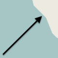 |
 | |
| natural | crevasse | A large crack in a glacier |  | ||
| natural | geyser | A spring characterized by intermittent discharge of water ejected turbulently and accompanied by steam. | 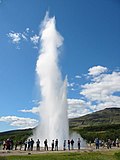 | ||
| natural | glacier | Lodowiec |  |
 | |
| natural | hot_spring | A spring of geothermally heated groundwater |  | ||
| natural | isthmus | A narrow strip of land, bordered by water on both sides and connecting two larger land masses. |  | ||
| natural | mud | Muł (W innych językach) | 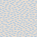 |
 | |
| natural | peninsula | A piece of land projecting into water from a larger land mass, nearly surrounded by water | 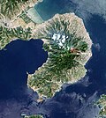 | ||
| natural | reef | A feature (rock, sandbar, coral, etc) lying beneath the surface of the water |  | ||
| natural | shingle | An accumulation of rounded rock fragments on a beach or riverbed |  |
 | |
| natural | shoal | An area of the sea floor near the sea surface (literally, becomes shallow) and exposed at low tide. See natural=sand as well.
|
 |
 | |
| natural | spring | Źródło |  | ||
| natural | strait | A narrow area of water surrounded by land on two sides and by water on two other sides. |  |
 | |
| natural | water | Naturalny zbiornik wodny - jezioro, staw itp. Dla większych zbiorników natural=coastline
|
 |
 | |
| natural | wetland | Obszar podmokły - mokradła, bagna, trzęsawiska. |  |
 | |
Kształt terenu | |||||
| natural | arch | A rock arch naturally formed by erosion, with an opening underneath. | currently not rendered by OSM Carto |  | |
| natural | arete | Grań |  |
 | |
| natural | bare_rock | An area with sparse/no soil or vegetation, so that the bedrock becomes visible. |  |
 | |
| natural | blockfield | A surface covered with boulders or block-sized rocks, usually the result of volcanic activity or associated with alpine and subpolar climates and ice ages. | Currently not rendered by OSM Carto |  | |
| natural | cave_entrance | Wejście do jaskini |  | ||
| natural | cliff | Klif. Znacznie pionowa lub prawie pionowa, ściana skalna (należy zaznaczyć część dolną po prawej stronie linii wektora.) |  |
 | |
| natural | dune | A hill of sand formed by wind, covered with no or very little vegetation. See also natural=sand and natural=beach
|
currently not rendered by OSM Carto |  | |
| natural | earth_bank | Large erosion gully or steep earth bank |  | ||
| natural | fumarole | A fumarole is an opening in a planet's crust, which emits steam and gases |  | ||
| natural | gorge | A gorge or canyon, including variants like ravine or slot canyon, is a narrow valley with steep, typically rocky walls. | currently not rendered by OSM Carto |  | |
| natural | gully | Small scale cut in relief created by water erosion |  | ||
| natural | hill | A hill. | currently not rendered by OSM Carto |  | |
| natural | peak | Szczyt góry |  | ||
| natural | ridge | Grzbiet górski |  |
 | |
| natural | rock | Ten znacznik sugerowano do mapowania obszarów małych wysepek i skał, które mogą być wykorzystywane do nawigacji lub mogą być potencjalnym zagrożeniem dla nawigacji. | currently not rendered by OSM Carto |  | |
| natural | saddle | Przełęcz między wzgórzami. |  | ||
| natural | sand | Tereny piaszczyste, porośnięte luźną roślinnością lub jej pozbawione. |  |
 | |
| natural | scree | Piarg. Rumowisko skalne. |  |
 | |
| natural | sinkhole | Naturalny otwór w powierzchni ziemi lub depresja. | currently not rendered by OSM Carto |  | |
| natural | stone | Skałka lub głaz. | currently not rendered by OSM Carto |  | |
| natural | valley | A natural depression flanked by ridges or ranges of mountains or hills | currently not rendered by OSM Carto |  | |
| natural | volcano | Wulkan. |  | ||
| natural | user defined | All commonly used values according to Taginfo | |||
This table is a wiki template with a default description in English. Editable here.


