Tag:highway=unclassified
 |
| Description |
|---|
| Public access road, non-residential. |
| Rendering in OSM Carto |

|
| Group: highways |
| Used on these elements |
| Useful combination |
| Status: de facto |
| Tools for this tag |
|
highway=unclassified is used for minor public roads, typically at the lowest level of whatever administrative hierarchy is used in that jurisdiction.
Unclassified roads are
- public roads
- less important than tertiary roads
- considered usable by motor cars
- not residential streets or agricultural tracks
Example uses would be
- roads used only for local traffic
- roads of low importance near the outskirts of town and cities (if not residential)
Physically, roads that should be tagged highway=unclassified can vary greatly between countries. However, within the same local area, physical comparisons can be made to decide the level of importance. Use the mapping customs in your own country, together with your knowledge and judgment. 'Unclassified roads' can even vary between different parts of a country: eg, they may be unpaved in poorer or rural areas, and paved in richer or urban areas. In this case, you should add a surface=* tag to indicate the surface.
Use highway=road for roads where you don't yet know which more specific OSM highway=* tag value you should use.
In other words, don't use highway=unclassified just because you don't know what road type it is. The value unclassified is indeed a classification, meaning 'very minor road'. (This can be confusing, but at this point it is not feasible to change the meaning of the tag in OSM: it began in the UK road classification system, where it means 'road too small for a classification number'. These roads have fewer rules about safety signage, etc.)
How to map
When is this applicable?
In short, when other highway=* tags are more applicable, use those instead. If a public road is of lesser importance than what's called a highway=tertiary in your region, and is also not a highway=residential, a highway=service, or a highway=track, then it's probably an unclassified road. The distinction between unclassified and tertiary often causes confusion: in general, always consider the road's relative importance in the region's road network and tag appropriately.
Situations where other tags should be used
- Residential roads, primarily for access to properties, should be tagged highway=residential instead.
- In rural contexts, narrow paved roads with only private access for motorcars (maybe public access for agricultural motor-vehicles, cyclists and pedestrians) should be tagged as highway=service and motorcar=private (maybe motor_vehicle=agricultural).
- Where the OSM road class is unclear or undetermined use highway=road.
- UK: unsurfaced country roads ("green lanes") should be tagged as highway=track if they are unfit for standard motorcar usage but available to 4x4, bikes and foot usage.
Examples of determining applicability
These are context-specific examples of how one might use local knowledge to exclude other potential classifications and arrive at highway=unclassified. Please note that there is no single, universally applicable set of physical criteria which can be used.
In an urban context, unclassified roads may be more likely to have pavements (sidewalks) and be fit for two-way traffic than in rural areas in the same region. They are commonly found in industrial, retail, or commercial areas, or linking to residential neighbourhoods. They might be distinguishable from tertiary roads in the same geographical region by their:
- Being narrower, perhaps requiring you to drive slower;
- Having a lower speed limit than the tertiary roads;
- Being the most minor type of
![[W]](/w/images/2/24/Wikipedia-16px.png "Wikipedia") distributor road;
distributor road; - Being side road linking developments into more major roads;
- Lack of any visible classification; or,
- Lower classifications, for countries which classify both and where the official classifications drive OSM tagging.
In a rural context, unclassified roads might be distinguished from tertiary roads in the same geographical region by their:
- Being narrower, such that vehicles might even need to slow down to pass in opposite directions;
- Being unpaved, in less populous or poorer regions when the tertiary roads are not;
- Being used more for access than for through traffic between towns and villages;
- Lack of any visible classification; or,
- Lower classifications, for countries which classify both and where the official classifications drive OSM tagging.
Determining public/private status when it's unclear
If the "public" vs. "private" status is unclear, a road can be considered public for motor cars if any of the following apply:
- The road is the only connection to a village, hamlet or commercial area.
- The road is an officially signposted connection to a residential or commercial area.
- The quality or width of the road is significantly greater than other paved roads (tracks) in the area.
- From experience you know that the road is frequently and legally used as a through route or to reach a (non-farm) workplace or tourist attraction.
- The road has any standard traffic markings or signs (perhaps including city limit signs, depending of how usual they are in your country).
Supplementary tags
Since physical characteristics vary between regions, and because the assumptions a data consumer may make in urban and rural contexts vary, it is helpful to explicitly tag some features of the road.
| Tag | Meaning |
|---|---|
| sidewalk=both/right/left/none | Used to indicate the presence or absence of a sidewalk, a parallel path for non-vehicular traffic which is called a "pavement" in some countries. Typically absent in rural contexts, common in urban contexts, but it's better to represent sidewalks explicitly. |
| footway=both/right/left/none | This is an older scheme for indicating the presence or absence of sidewalks/pavements/parallel non-vehicular paths. |
| lit=* | Indicates the presence or absence of street lighting. Only likely in urban contexts. |
| surface=* | Explicitly mark the type of road surface. |
| lanes=* | Explicitly record the total number of marked lanes (both directions, minimum 1). |
| abutters=* | Indicates the local context of the road; may be omitted if there's nothing notable to the sides of the road, or less subjectively: if there's a surrounding landuse area and you'd just be reiterating that implicit context. |
| winter_service=* | if winter service is provided |
International usage
This tag is intended for use in all countries, for public roads at the very lowest level of classification or which actually are unclassified, and which are of lesser importance than a tertiary road.
The definition of this tag evolved from a scheme to describe the rather populated British countryside, where most of the public roads are paved because they also carry much non-agricultural traffic. The name derives from the official "U" classification used by UK local councils, but the OSM tag has also been applied to roads which carry other official classifications: the "D" and "C" categories in particular. This has happened because these three official classifications are typically not signposted and so have historically not been available to OSM mappers; nevertheless, the tag is still useful for marking low-importance minor roads.
In primarily rural and often mountainous areas i.e. in Germany the countryside is characterised by many paved tracks of grade1 with primarily agricultural traffic.
Note that some correctly tagged highway=unclassified may have an official number, announced with road signs - ref=* should be used in such situation to record this number.
Gallery
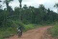
It's not about the size or condition of the road, it's about its importance or role or function.
Road looking in the same way may be also highway=track or 'highway=service + service=driveway' etc. This means that an "unclassified road" might look like this, not that it is an "unclassified road".
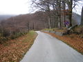

Unclassified road through the forest


| ||||||||||||||||||||||||||||||