Ko:Tag:highway=unclassified
 |
| 설명 |
|---|
| 주거지역이 아닌 곳의 공공 접근 도로. |
| OSM Carto에서 렌더링 |

|
| 그룹: 도로 |
| 해당 요소의 사용 |
| 유용한 조합 |
| 같이 보기 |
| 상태:사실상 표준 |
| 이 태그를 위한 도구 |
highway=unclassified는 일반적으로 해당 관할 구역에서 사용되는 행정 계층 구조 중 가장 낮은 수준의 소규모 공공 도로에 씁니다.[1]
미분류 도로(Unclassified road)는,
- 공공 도로
- 3차 도로보다 중요성이 덜함
- 자동차를 쓸 수 있을 정도
- 주거 도로나 농로가 아님
사용되는 보기로는,
- 지역 교통에만 사용되는 도로
- 마을이나 도시 바깥 가까이에서 중요도가 낮은 도로(주거용이 아닌 경우)
물리적으로 highway=unclassified로 갈래지어야 하는 도로는 나라마다 크게 다를 수 있습니다. 그러나 같은 지역 내에서는 물리적으로 비교해서 중요도를 결정할 수 있습니다. 해당 국가의 매핑 관례와 지식 및 판단을 함께 사용하세요. '미분류 도로'는 한 국가 내에서도 지역마다 다를 수 있습니다. 보기를 들어 가난한 지역이나 농촌 지역에서는 비포장 도로이고 부유한 지역이나 도시 지역에서는 포장 도로일 수 있습니다. 이 경우 surface=*를 추가하여 표면을 표시해야 합니다.
한국에서 “미분류 도로”에 대해서는 미분류 도로(4차 도로;미등급 도로)를 참고 하시기 바랍니다.
참고: 어떤 OSM highway=* 태그 값을 사용해야 할지 자세히 모르는 도로에는 highway=road를 사용하십시오.
즉, 어떤 도로 유형인지 모른다고 해서 highway=unclassified를 사용하지 마십시오. 미분류 값은 실제로는 '매우 사소한 도로'를 의미하는 분류입니다. (이 태그는 '분류 번호에 비해 너무 작은 도로'를 의미하는 영국 도로 분류 시스템에서 시작되었기 때문에 혼란스러울 수 있지만, 현재로서는 OSM에서 이 태그의 의미를 변경하는 것이 불가능합니다. 이러한 도로는 안전 표지판 등에 의한 규칙이 적습니다.)
그리는 방법
When is this applicable?
In short, when other highway=* tags are more applicable, use those instead. If a public road is of lesser importance than what's called a highway=tertiary in your region, and is also not a highway=residential, a highway=service, or a highway=track, then it's probably an unclassified road. The distinction between unclassified and tertiary often causes confusion: in general, always consider the road's relative importance in the region's road network and tag appropriately.
Situations where other tags should be used
- Residential roads, primarily for access to properties, should be tagged
highway=residentialinstead. - In rural contexts, narrow paved roads with only private access for motorcars (maybe public access for agricultural motor-vehicles, cyclists and pedestrians) should be tagged as
highway=serviceandmotorcar=private(maybemotor_vehicle=agricultural). - Where the OSM road class is unclear or undetermined use
highway=road. - UK: unsurfaced country roads ("green lanes") should be tagged as
highway=trackif they are unfit for standard motorcar usage but available to 4x4, bikes and foot usage.
Examples of determining applicability
These are context-specific examples of how one might use local knowledge to exclude other potential classifications and arrive at highway=unclassified. Please note that there is no single, universally applicable set of physical criteria which can be used.
In an urban context, unclassified roads may be more likely to have pavements (sidewalks) and be fit for two-way traffic than in rural areas in the same region. They are commonly found in industrial, retail, or commercial areas, or linking to residential neighbourhoods. They might be distinguishable from tertiary roads in the same geographical region by their:
- Being narrower, perhaps requiring you to drive slower;
- Having a lower speed limit than the tertiary roads;
- Being the most minor type of
![[W]](https://upload.wikimedia.org/wikipedia/commons/thumb/0/00/Tango_style_Wikipedia_Icon_no_shadow.svg/20px-Tango_style_Wikipedia_Icon_no_shadow.svg.png?utm_source=commons.wikimedia.org&utm_campaign=imageinfo&utm_content=thumbnail) distributor road;
distributor road; - Being side road linking developments into more major roads;
- Lack of any visible classification; or,
- Lower classifications, for countries which classify both and where the official classifications drive OSM tagging.
In a rural context, unclassified roads might be distinguished from tertiary roads in the same geographical region by their:
- Being narrower, such that vehicles might even need to slow down to pass in opposite directions;
- Being unpaved, in less populous or poorer regions when the tertiary roads are not;
- Being used more for access than for through traffic between towns and villages;
- Lack of any visible classification; or,
- Lower classifications, for countries which classify both and where the official classifications drive OSM tagging.
Determining public/private status when it's unclear
If the "public" vs. "private" status is unclear, a road can be considered public for motor cars if any of the following apply:
- The road is the only connection to a village, hamlet or commercial area.
- The road is an officially signposted connection to a residential or commercial area.
- The quality or width of the road is significantly greater than other paved roads (tracks) in the area.
- From experience you know that the road is frequently and legally used as a through route or to reach a (non-farm) workplace or tourist attraction.
- The road has any standard traffic markings or signs (perhaps including city limit signs, depending of how usual they are in your country).
Supplementary tags
Since physical characteristics vary between regions, and because the assumptions a data consumer may make in urban and rural contexts vary, it is helpful to explicitly tag some features of the road.
| Tag | Meaning |
|---|---|
sidewalk=both/right/left/none
|
Used to indicate the presence or absence of a sidewalk, a parallel path for nonvehicular traffic which is called a "pavement" in some countries. Typically absent in rural contexts, common in urban contexts, but it's better to represent sidewalks explicitly. |
footway=both/right/left/none
|
This is an older scheme for indicating the presence or absence of sidewalks/pavements/parallel nonvehicular paths. |
lit=*
|
Indicates the presence or absence of street lighting. Only likely in urban contexts. |
surface=*
|
Explicitly mark the type of road surface. |
lanes=*
|
Explicitly record the total number of marked lanes (both directions, minimum 1). |
abutters=*
|
Indicates the local context of the road; may be omitted if there's nothing notable to the sides of the road, or less subjectively: if there's a surrounding landuse area and you'd just be reiterating that implicit context. |
winter_service=*
|
if winter service is provided |
International usage
This tag is intended for use in all countries, for public roads at the very lowest level of classification or which actually are unclassified, and which are of lesser importance than a tertiary road.
The definition of this tag evolved from a scheme to describe the rather populated British countryside, where most of the public roads are paved because they also carry much non-agricultural traffic. The name derives from the official "U" classification used by UK local councils, but the OSM tag has also been applied to roads which carry other official classifications: the "D" and "C" categories in particular. This has happened because these three official classifications are typically not signposted and so have historically not been available to OSM mappers; nevertheless, the tag is still useful for marking low-importance minor roads.
In primarily rural and often mountainous areas i.e. in Germany the countryside is characterised by many paved tracks of grade1 with primarily agricultural traffic.
Note that some correctly tagged highway=unclassified may have an official number, announced with road signs - ref=* should be used in such situation to record this number.
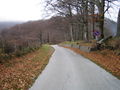
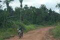
이미지 모음
도로의 규모나 상태가 아니라 중요도나 역할 또는 기능에 주목해야 합니다.
규모나 상태 만으로는 highway=track 또는 'highway=service + service=driveway' 등일 수도 있습니다. 즉, '미분류 도로'가 이런 모양일 수도 있다는 것이지, 이런 모양이 '미분류 도로'라는 것은 아닙니다.
-
-
-
 Unclassified road through the forest
 -

-

-


함께 보기
각주
- ↑ 영국의 도로 분류 체계에서 시작된 낱말로, 도로의 등급 분류에 속하지 않기 때문에 'unclassified'-한말글로는 '분류되지 않은', '등급 분류 번호가 붙지 않은'-라는 표현을 쓰며, 3차에 이은 '4차 도로'라고도 합니다.
| ||||||||||||||||||||||||||||||