MUTCD/W
Series W of the MUTCD is for warning signs.
Temporary warning signs
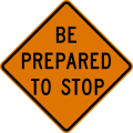
This series includes warning signs for temporary traffic control zones, i.e., construction zones, as well as for incident management areas. Whereas a regulatory sign appears the same inside and outside a construction zone, a temporary warning sign has an orange background instead of the usual yellow, and an incident management warning sign has a fluorescent pink background. California and Texas place construction warning signs in separate series C and CW, respectively. Incident management area signs are not to be confused with the emergency management signs of Series EM.
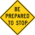
- W3-4
-
 Normal
 -
 Construction zone
 -
 Incident management area
In general, OpenStreetMap only maps long-term closures and construction sites. For routing purposes, short-term construction is more reliably and efficiently tracked in incident management systems along with real-time traffic congestion data. However, if a temporary warning sign happens to be posted on a long-term basis for some reason, you can map it as you would map a permanent warning sign. If you map the temporary traffic sign as a node, use a W code but add colour=orange or pink to the node.
W1: Curves and Turns
| Sign or plaque | Designation | Name | Tags | Notes |
|---|---|---|---|---|
 
|
W1-1L | Turn | hazard=turn
| |
 
|
W1-1R | |||
 
|
W1-2L | Curve | hazard=curve
| |
 
|
W1-2R | |||
 
|
W1-3L | Reverse Turn | hazard=turns
| |
 
|
W1-3R | |||
 
|
W1-4L | Reverse Curve | hazard=curves curves=serpentine
| |
 
|
W1-4R | |||

|
W1-4bL | Reverse Curve (2 lanes) | hazard=curves curves=serpentine change=no |
Speculative |

|
W1-4bR | |||

|
W1-4cL | Reverse Curve (3 or more lanes) | hazard=curves curves=serpentine change=no |
Speculative |

|
W1-4cR | |||

|
W1-5L | Winding Road | hazard=curves curves=extended
| |

|
W1-5R | |||
 
|
W1-6L | One-Direction Large Arrow | hazard=turn
| |
 
|
W1-6R | |||
 
|
W1-7 | Two-Direction Large Arrow | hazard=dangerous_junction
|
|
| W1-8L | Chevron Alignment | hazard=curve
| ||
| W1-8R | ||||

|
W1-10L | Combination Horizontal Alignment/Intersection | hazard=curve;dangerous_junction
| |

|
W1-10R | |||

|
W1-10aL | Combination Horizontal Alignment/Intersection | hazard=curve;dangerous_junction
| |

|
W1-10aR | |||

|
W1-10bL | Combination Horizontal Alignment/Intersection | hazard=curve;dangerous_junction
| |

|
W1-10bR | |||

|
W1-10cL | Combination Horizontal Alignment/Intersection | hazard=curve;dangerous_junction
| |

|
W1-10cR | |||

|
W1-10dL | Combination Horizontal Alignment/Intersection | hazard=curves;dangerous_junction curves=serpentine
| |

|
W1-10dR | |||

|
W1-10eL | Combination Horizontal Alignment/Intersection | hazard=curves;dangerous_junction curves=serpentine
| |

|
W1-10eR | |||

|
W1-11L | Hairpin Curve | hazard=curve curve=hairpin
| |

|
W1-11R | |||

|
W1-13L | Truck Rollover | hazard:hgv=rollover |
Speculative |

|
W1-13R | |||

|
W1-15 | 270-degree Loop | hazard=curve curve=loop
|
W2: Intersections
| Sign or plaque | Designation | Name | Tags | Notes |
|---|---|---|---|---|

|
W2-1 | Intersection Warning | hazard=dangerous_junction
| |

|
W2-2L | Intersection Warning | hazard=dangerous_junction
| |

|
W2-2R | |||

|
W2-3L | Intersection Warning | hazard=dangerous_junction
| |

|
W2-3R | |||

|
W2-3aL | Intersection Warning | hazard=dangerous_junction
| |

|
W2-3aR | |||

|
W2-4 | T-intersection | hazard=dangerous_junction
| |

|
W2-5 | Intersection Warning | hazard=dangerous_junction
| |

|
W2-6 | Circular Intersection | hazard=roundabout junction=roundabout
| |

|
W2-7L | Offset Side Roads | hazard=dangerous_junction
| |

|
W2-7R | |||

|
W2-8L | Double Side Roads | hazard=dangerous_junction
| |

|
W2-8R | |||

|
W2-10 | Traffic Entering When Flashing | highway=priority at the intersectionhighway=stop stop=minor at the stop line of the cross streetflashing_lights=yes on the traffic sign node
| |

|
W2-11 | Traffic Approaching When Flashing | highway=priority at the intersectionhighway=stop stop=minor at the stop line of this streetflashing_lights=yes on the traffic sign node
|
W3: Advance Traffic Control
| Sign or plaque | Designation | Name | Tags | Notes | |
|---|---|---|---|---|---|
 
|
W3-1 | Advanced Traffic Control | hazard=stophighway=stop ahead |
Speculative | |
 
|
W3-2 | Advanced Traffic Control | hazard=give_wayhighway=give_way ahead |
Speculative | |
 
|
W3-3 | Advanced Traffic Control | hazard=traffic_signalshighway=traffic_signals ahead
|
||
  
|
W3-4 | Be Prepared to Stop | hazard=queues_likely
| ||
 
|
W3-5 | Reduced Speed Limit Ahead | hazard=maxspeedmaxspeed=45 mph ahead |
Speculative | |
 
|
W3-5a | XX MPH Speed Zone Ahead | hazard=maxspeedmaxspeed=45 mph ahead |
Speculative | |

|
W3-5b | Variable Speed Zone Ahead | hazard=maxspeedmaxspeed:variable=yes ahead |
Speculative | |

|
W3-5c | XX MPH Truck Speed Zone Ahead | hazard=maxspeedmaxspeed:hgv=20 mph ahead |
Speculative | |

|
W3-6 | Draw Bridge | hazard=queues_likelybridge=movable ahead
| ||

|
W3-7 | Ramp Meter Ahead | hazard=traffic_signalshighway=traffic_signals traffic_signals=ramp_meter ahead
| ||

|
W3-8 | Ramp Metered When Flashing | hazard=traffic_signalshighway=traffic_signals traffic_signals=ramp_meter ahead
| ||

|
W3-9 | Traffic Using Shoulder | shoulder:right:access=*
|
W4: Lanes and Merges
| Sign or plaque | Designation | Name | Tags | Notes |
|---|---|---|---|---|
 
|
W4-1L | Merge | hazard=merge |
Speculative |
 
|
W4-1R | |||
 
|
W4-2L | Lane Ends | hazard=mergeturn:lanes=merge_to_left change:lanes=yes |
Speculative |
 
|
W4-2R | |||
 
|
W4-3L | Added Lane | hazard=acceleration_lanelanes=* |
Speculative |
 
|
W4-3R | |||
| W4-4P | Cross Traffic Does Not Stop (plaque) | hazard=dangerous_crossinghighway=stop stop=minor
| ||
| W4-4aP | Traffic From Left (Right) Does Not Stop (plaque) | hazard=dangerous_crossinghighway=stop stop=minor
| ||
| W4-4bP | Oncoming Traffic Does Not Stop (plaque) | hazard=dangerous_crossinghighway=stop stop=minor
| ||
 
|
W4-5 | Entering Roadway Merge | hazard=merge |
Speculative |
 
|
W4-5aP | No Merge Area (plaque) | hazard=no_acceleration_lane
| |
 
|
W4-6L | Entering Roadway Added Lane | hazard=acceleration_lanelanes=* |
Speculative |
 
|
W4-6R | |||

|
W4-7L | Heavy Merge from Right (Left) | hazard=merge |
Speculative |

|
W4-7R | |||

|
W4-8 | Single Lane Transition | hazard=road_narrowslanes=1
|
W5: Road Width Restrictions
| Sign or plaque | Designation | Name | Tags | Notes |
|---|---|---|---|---|
 
|
W5-1 | Road Narrows | hazard=road_narrowsnarrow=yes ahead
| |
 
|
W5-2 | Narrow Bridge | narrow=yes on bridge
| |

|
W5-2a | Narrow Underpass | narrow=yes on underpass
| |
 
|
W5-3 | One Lane Bridge | lanes=1 on bridge
| |

|
W5-3a | One Lane Underpass | lanes=1 on underpass
| |

|
W5-4 | Ramp Narrows | hazard=ramp_narrowsnarrow=yes ahead |
Speculative |

|
W5-4a | Path Narrows | hazard=road_narrowsnarrow=yes ahead
|
W6: Divided Highways
| Sign or plaque | Designation | Name | Tags | Notes |
|---|---|---|---|---|
 
|
W6-1 | Divided Highway | dual_carriageway=yes
| |
 
|
W6-2 | Divided Highway Ends | dual_carriageway=no
| |
 
|
W6-3 | Two-Way Traffic | oneway=no lanes=2
| |
| W6-4 | Two-Way Traffic | oneway=no
| ||

|
W6-5 | Two-Way Traffic (3-Lane) | oneway=no lanes=3 lanes:forward=1 lanes:backward=2
| |

|
W6-5a | Two-Way Traffic (3-Lane) | oneway=no lanes=3 lanes:forward=2 lanes:backward=1
|
W7: Hills and Grades
| Sign or plaque | Designation | Name | Tags | Notes |
|---|---|---|---|---|
 
|
W7-1 | Hill | incline=down
| |

|
W7-1a | Hill with Grade | incline=-8%
| |
| W7-2P | Use Low Gear (plaque) | ? | ||
| W7-2bP | Trucks Use Lower Gear (plaque) | ? | ||
| W7-3P | XX% Grade (plaque) | incline=-9%
| ||
| W7-3aP | Next XX Miles (plaque) | incline=* for 7 miles
| ||
| W7-3bP | XX% Grade, XX Miles (plaque) | incline=-9% for 7 miles
| ||

|
W7-4 | Runaway Truck Ramp XX Miles | highway=escape 1 mile ahead
| |

|
W7-4b | Runaway Truck Ramp (with arrow) | highway=escape 1 mile ahead
| |

|
W7-4c | Truck Escape Ramp | highway=escape
| |
| W7-4dP | Sand (plaque) | surface=sand
| ||
| W7-4eP | Gravel (plaque) | surface=gravel
| ||
| W7-4fP | Paved (plaque) | surface=paved
| ||

|
W7-5 | Hill | incline=down
| |

|
W7-6 | Hill Blocks View | ? |
W8: Pavement and Roadway Conditions
| Sign or plaque | Designation | Name | Tags | Notes |
|---|---|---|---|---|
 
|
W8-1 | Bump | traffic_calming=bumphazard=bump
| |
 
|
W8-2 | Dip | traffic_calming=diphazard=dip
| |
 
|
W8-3 | Pavement Ends | surface=unpaved
| |
 
|
W8-4 | Soft Shoulder | shoulder:surface=unpaved
| |
 
|
W8-5 | Slippery When Wet | hazard=slippery
| |

|
W8-5,W8-5P | Slippery When Wet | hazard:wet=slippery
| |

|
W8-5,W8-5aP | Slippery (Ice) | hazard=slippery;ice
| |

|
W8-5,W8-5bP | Slippery (Steel Deck) | hazard=slippery;metal_bridge_deck surface=steel
| |

|
W8-5,W8-5cP | Slippery (Excess Oil) | hazard=slippery surface=chipseal
| |
 
|
W8-6 | Truck Crossing | hazard=hgv_crossinghgv=designated on cross street |
Speculative |
 
|
W8-7 | Loose Gravel | hazard=loose_gravelsurface=gravel
| |
 
|
W8-8 | Rough Road | hazard=rough_roadsmoothness=*
| |
 
|
W8-9 | Low Shoulder | ? | |

|
W8-10 | Bicycle Surface Condition | hazard=slippery surface=*
| |
| W8-10P | Slippery When Wet (plaque) | hazard=slippery surface=*
| ||
 
|
W8-11 | Uneven Lanes | ? | |
 
|
W8-12 | No Center Line | lane_markings=no
| |

|
W8-13 | Bridge Ices Before Road | hazard=ice on bridge
| |
 
|
W8-14 | Fallen Rocks | hazard=falling_rocks
| |
 
|
W8-15 | Grooved Pavement | surface=grooved_asphalt hazard=grooves |
Speculative |
 |
W8-15,W8-15aP | Grooved Pavement (Motorcycle) | surface=grooved_asphalt hazard:motorcycle=grooves |
Speculative |
 
|
W8-16 | Metal Bridge Deck | surface=metal hazard=metal_bridge_deck on the bridge |
Speculative |
 |
W8-16,W8-15P | Metal Bridge Deck (Motorcycle) | surface=metal hazard:motorcycle=metal_bridge_deck on the bridge |
Speculative |
 
|
W8-17 | Shoulder Drop Off (symbol) | ? | |
| W8-17P | Shoulder Drop-Off (plaque) | ? | ||
 
|
W8-18 | Road May Flood | flood_prone=yes
| |
| W8-19 | Flood Gauge | man_made=monitoring_station monitoring:water_level=yes display:analog=yes recording:manually=yes
| ||

|
W8-21 | Gusty Winds Area | hazard=side_winds
| |

|
W8-22 | Fog Area | hazard=fog |
Speculative |
 
|
W8-23 | No Shoulder | shoulder=no
| |

|
W8-24 | Steel Plate Ahead | surface=metal ahead
| |
 .svg)
|
W8-25 | Shoulder Ends | shoulder=no
| |

|
W8-26 | Road Ends | noexit=yes in 500 feet (150 m)
| |

|
W8-26a | Street Ends | noexit=yes in 500 feet (150 m)
|
W9: Lane Transitions
| Sign or plaque | Designation | Name | Tags | Notes |
|---|---|---|---|---|

|
W9-1 | Left (Right) Lane Ends | hazard=lane_changing
| |

|
W9-2a | Merge Here Take Turns | hazard=road_narrowslanes=1
| |

|
W9-3L | Interior Lane Shift | access:lanes=|no|
| |

|
W9-3R | |||

|
W9-4 | Lanes Merge | hazard=road_narrowslanes=1
| |

|
W9-5 | Bicycle Lane Ends | hazard=lane_changingcycleway=shared_lane or shared
| |
 
|
W9-5a | Bicycles Merging | hazard=lane_changingcycleway=shared_lane or shared
| |

|
W9-6 | Pay Toll XX Miles Cars (price) | barrier=toll_booth charge:motorcar=0.75 USD 1 mile aheadtoll=yes from 1 mile ahead
| |

|
W9-6a | Stop Ahead Pay Toll Cars (price) | barrier=toll_booth charge:motorcar=0.75 USD 1 mile aheadtoll=yes from up ahead
| |
| W9-6bP | Pay Toll XX Miles Cars (price) (plaque) | barrier=toll_booth charge:motorcar=0.75 USD 1 mile aheadtoll=yes from 1 mile ahead
| ||
| W9-6cP | Stop Ahead Pay Toll (plaque) | barrier=toll_booth aheadtoll=yes from up ahead
| ||

|
W9-6dP | Stop Ahead Pay Toll (plaque) | barrier=toll_booth aheadtoll=yes from up ahead
| |

|
W9-6e | Take Ticket XX Miles | amenity=vending_machine vending=toll drive_through=yes 2 miles (3.2 km) aheadtoll=yes from 2 miles (3.2 km) ahead
| |

|
W9-6f | Stop Ahead – Take Ticket | amenity=vending_machine vending=toll drive_through=yes aheadtoll=yes from up ahead
| |
| W9-6gP | Take Ticket XX Miles (plaque) | amenity=vending_machine vending=toll drive_through=yes 2 miles (3.2 km) aheadtoll=yes from 2 miles (3.2 km) ahead
| ||
| W9-6hP | Stop Ahead – Take Ticket (plaque) | amenity=vending_machine vending=toll drive_through=yes aheadtoll=yes from up ahead
| ||

|
W9-7L | Right (Left) Lane Exit Only Ahead | turn:lanes=slight_left change:lanes=yeshighway=motorway_junction ahead
| |

|
W9-7R |
W10: Rail and Light Rail
| Sign or plaque | Designation | Name | Tags | Notes |
|---|---|---|---|---|

|
W10-1 | Grade Crossing Advance Warning | hazard=level_crossingrailway=level_crossing ahead |
|
| W10-1aP | Exempt (plaque) | ? | ||

|
W10-2L | Grade Crossing and Intersection Advance Warning | hazard=level_crossing;dangerous_junctionrailway=level_crossing nearby
| |

|
W10-2R | |||

|
W10-3L | Grade Crossing and Intersection Advance Warning | hazard=level_crossing;dangerous_junctionrailway=level_crossing nearby
| |

|
W10-3R | |||

|
W10-4L | Grade Crossing and Intersection Advance Warning | hazard=level_crossing;dangerous_junctionrailway=level_crossing ahead
| |

|
W10-4R | |||

|
W10-5 | Low Ground Clearance | hazard=ground_clearance
| |
| W10-5P | Low Ground Clearance (plaque) | hazard=ground_clearance
| ||

|
W10-7 | Light Rail Activated Blank-Out Symbol | ? | |

|
W10-8 | Trains May Exceed 80 MPH | maxspeed=* on the railroad tracks |
highspeed=yes if 124 miles per hour (200 km/h) or higher
|

|
W10-9 | No Train Horn | crossing:whistle=optional
| |
| W10-9P | No Train Horn (plaque) | crossing:whistle=optional
| ||

|
W10-11 | Storage Space Symbol | ? | |

|
W10-11a | Storage Space XX Feet Between Tracks & Highway | ? | |

|
W10-11b | Storage Space XX Feet Between Highway & Tracks Behind You | ? | |

|
W10-12 | Skewed Crossing | ? | |
| W10-13P | No Gates or Lights (plaque) | railway=level_crossing crossing:barrier=no crossing:light=no
| ||
| W10-14P | Next Crossing (plaque) | |||
| W10-14aP | Use Next Crossing (plaque) | |||
| W10-15P | Rough Crossing (plaque) | railway=level_crossing smoothness=*
| ||

|
W10-16 | Another Train Coming Activated Blank-Out | railway=level_crossing tracks=*
| |

|
W10-21 | Busway Crossing | highway=busway intersecting the roadway |
How to tag the crossing itself? |
| W10-21aP | Signal Ahead (plaque) | highway=traffic_signals at the stop line ahead
|
W11: Advance Warnings and Crossings


W12: Low Clearance
| Sign or plaque | Designation | Name | Tags | Notes |
|---|---|---|---|---|
 
|
W12-1 | Double Arrow | Map each side as a separate way | |
 
|
W12-2 | Low Clearance Ahead | maxheight=12'6" ahead
|
|
| W12-2a | Low Clearance Overhead | maxheight=14'4" on the roadway below
|
||
| W12-2b | Low Clearance – Lane Overhead | maxheight:lanes=14'4" on the roadway below
|
W13: Advisory Speeds
| Sign or plaque | Designation | Name | Tags | Notes |
|---|---|---|---|---|
 
|
W13-1P | Advisory Speed (plaque) | maxspeed:advisory=35 mph
| |
| W13-1aP | Advisory Speed Confirmation (plaque) | maxspeed:advisory=35 mph
| ||

|
W13-2 | Advisory Exit Speed | highway=*_link maxspeed:advisory=25 mph
| |

|
W13-3 | Advisory Ramp Speed | highway=*_link maxspeed:advisory=35 mph
| |

|
W13-4P | On Ramp (plaque) | ||

|
W13-6 | Combination Horizontal Alignment/Advisory Exit Speed Loop | hazard=loop highway=*_link maxspeed:advisory=25 mph |
Speculative |

|
W13-7 | Combination Horizontal Alignment/Advisory Ramp Speed Loop | hazard=loop highway=*_link maxspeed:advisory=25 mph |
Speculative |

|
W13-8 | Combination Horizontal Alignment/Advisory Exit Speed Loop | hazard=loop highway=*_link maxspeed:advisory=25 mph |
Speculative |

|
W13-9 | Combination Horizontal Alignment/Advisory Ramp Speed Loop | hazard=loop highway=*_link maxspeed:advisory=25 mph |
Speculative |

|
W13-10 | Combination Horizontal Alignment/Advisory Exit Speed Turn | hazard=turn highway=*_link maxspeed:advisory=20 mph |
Speculative |

|
W13-11 | Combination Horizontal Alignment/Advisory Ramp Speed Turn | hazard=turn highway=*_link maxspeed:advisory=20 mph |
Speculative |

|
W13-12 | Combination Horizontal Alignment/Advisory Exit Speed – Truck Rollover | hazard:hgv=turn highway=*_link maxspeed:advisory=20 mph |
Speculative |

|
W13-13 | Combination Horizontal Alignment/Advisory Ramp Speed – Truck Rollover | hazard:hgv=turn highway=*_link maxspeed:advisory=20 mph |
Speculative |

|
W13-20 | Vehicle Speed Feedback Sign | highway=speed_display maxspeed=*
| |
| W13-20aP | Vehicle Speed Feedback Sign (plaque) | highway=speed_display maxspeed=*
|
W14: Dead End Streets and No Passing Zones
| Sign or plaque | Designation | Name | Tags | Notes |
|---|---|---|---|---|

|
W14-1 | Dead End | ||
| W14-1aL | Dead End (with arrow) | |||
| W14-1aR | ||||

|
W14-2 | No Outlet | ||
| W14-2aL | No Outlet (with arrow) | |||
| W14-2aR | ||||
 
|
W14-3 | No Passing Zone | overtaking=no
|
W15: Playground
| Sign or plaque | Designation | Name | Tags | Notes |
|---|---|---|---|---|

|
W15-1 | Playground | hazard=childrenleisure=playground nearby
|
W16: Supplemental
| Sign or plaque | Designation | Name | Tags | Notes |
|---|---|---|---|---|
| W16-1P | In Road (plaque) | cycleway=shared_lane bicycle=designated or carriage=designated
| ||
| W16-1aP | In Street (plaque) | cycleway=shared_lane bicycle=designated or carriage=designated
| ||
| W16-2P | XX Feet | distance=500' on the traffic sign
| ||
| W16-2aP | XX Ft | distance=500' on the traffic sign
| ||
| W16-3P | XX Miles (2-line plaque) | distance=2 mi on the traffic sign
| ||
| W16-3aP | XX Miles (1-line plaque) | distance=2 mi on the traffic sign
| ||
| W16-4P | Next XX Feet (plaque) | distance=500' on the traffic sign
| ||
| W16-5PL | Supplemental Arrow (plaque) | |||
| W16-5PR | ||||
| W16-6PL | Supplemental Arrow (plaque) | |||
| W16-6PR | ||||
| W16-7PL | Downward Diagonal Arrow (plaque) | |||
| W16-7PR | ||||
| W16-7aP | Dual Downward Diagonal Arrow (plaque) | |||
| W16-8P | Advance Street Name (1-line plaque) | name=1st Street on cross street
| ||
| W16-8aP | Advance Street Name (2-line plaque) | name=Elm Street on cross street at leftname=Lumsden Road on cross street at right
| ||
| W16-9P | Ahead (plaque) | |||
| W16-10P | Photo Enforced (symbol plaque) | type=enforcementhighway=speed_camera or man_made=surveillance surveillance:type=camera surveillance:zone=traffic
| ||
| W16-10aP | Photo Enforced (plaque) | type=enforcementhighway=speed_camera or man_made=surveillance surveillance:type=camera surveillance:zone=traffic
| ||
| W16-11P | High-Occupancy Vehicles (plaque) | hov=designated
| ||
| W16-12P | Traffic Circle (plaque) | hazard=roundabout junction=roundabout
| ||
| W16-12aP | Roundabout (plaque) | hazard=roundabout junction=roundabout
| ||
| W16-13P | When Flashing (plaque) | ? | ||
| W16-15P | New (plaque) | ? | ||
| W16-16P | Last Exit Before Toll (1-line plaque) | highway=motorway_junction at the exittoll=yes past the exit
| ||
| W16-16aP | Last Exit Before Toll (2-line plaque) | highway=motorway_junction at the exittoll=yes past the exit
| ||
| W16-17P | Toll (plaque) | destination:ref=* Toll on a ramptoll=yes on the toll road
| ||
| W16-18P | Notice (plaque) | ? | ||
| W16-19P | Last in Corridor (plaque) | ? | ||
| W16-20P | Except Bicycles (plaque) | except=bicycle
| ||
| W16-21P | 2-Way Bicycle Cross Traffic (plaque) | highway=cycleway oneway=no across the roadway
|
W17: Speed Hump
| Sign or plaque | Designation | Name | Tags | Notes |
|---|---|---|---|---|

|
W17-1 | Speed Hump | traffic_calming=hump
|
W18: No Traffic Signs
| Sign or plaque | Designation | Name | Tags | Notes |
|---|---|---|---|---|

|
W18-1 | No Traffic Signs | ? |
W19: End of Controlled Access Highway
| Sign or plaque | Designation | Name | Tags | Notes |
|---|---|---|---|---|
| W19-1 | Freeway Ends XX Miles | End highway=motorway in 1 mile
| ||
| W19-2 | Expressway Ends XX Miles | End expressway=yes in 1 mile
| ||

|
W19-3 | Freeway Ends | End highway=motorway at this point
| |

|
W19-4 | Expressway Ends | End expressway=yes at this point
| |

|
W19-5 | All Traffic Must Exit | highway=construction or highway=proposed ahead
|
W20: Work Zones
| Sign or plaque | Designation | Name | Tags | Notes |
|---|---|---|---|---|

|
W20-1 | Road Work (with distance) | ? | |

|
W20-1b | Path Work (with distance) | ? | |

|
W20-2 | Detour Advance | ? | |

|
W20-2a | Bike Detour (with distance) | ? | |
| File:MUTCD CW20-2b.svg | W20-2b | Bike Diversion (with distance) | ? | |
.svg)
|
W20-3 | Road Closed Advance | access=no ahead
| |

|
W20-3a | Path Closed Advance | access=no ahead
| |

|
W20-4 | One Lane Road Advance | lanes=1 1,000 feet ahead
| |

|
W20-5 | Lane(s) Closed | access:lanes=|no
| |

|
W20-5a | Lane(s) Closed (with distance) | access:lanes=|no|no
| |

|
W20-5b | Bike Lane Closed (with distance) | ? | |
 
|
W20-7 | Flagger (symbol) | supervised=yes
| |

|
W20-7a | Flagger | supervised=yes
| |

|
W20-8 | Slow (on Stop/Slow Paddle) | ? |
W21: Road Work
| Sign or plaque | Designation | Name | Tags | Notes |
|---|---|---|---|---|
 
|
W21-1 | Workers | hazard=roadworks
| |

|
W21-1a | Workers | hazard=roadworks
| |

|
W21-2 | Fresh Oil (Tar) | surface=asphalt smoothness=excellent
| |

|
W21-3 | Road Machinery Ahead | ||
| W21-4 | Slow Moving Vehicle | |||

|
W21-5 | Shoulder Work | ? | |

|
W21-5a | Shoulder Closed | shoulder:right:access=no
| |

|
W21-5b | Shoulder Closed (with distance) | shoulder:right:access=no 1,000 feet ahead
| |

|
W21-6 | Survey Crew | ||

|
W21-7 | Utility Work Ahead | ||

|
W21-8 | Mowing Ahead |
W22: Blasting Zones
| Sign or plaque | Designation | Name | Tags | Notes |
|---|---|---|---|---|

|
W22-1 | Blasting Zone Ahead | ||

|
W22-3 | End Blasting Zone |
W23: Slow Traffic
| Sign or plaque | Designation | Name | Tags | Notes |
|---|---|---|---|---|
| W23-1 | Slow Traffic Ahead | ? | ||
 
|
W23-2 | New Traffic Pattern Ahead | Remap roads ahead using newest available imagery | |

|
W23-2a | New Signal Operation Ahead |
W24: Double Reverse Curves
| Sign or plaque | Designation | Name | Tags | Notes |
|---|---|---|---|---|
 
|
W24-1L | Double Reverse Curve (1 lane) | hazard=curves curves=double_reverse lanes=1 |
Speculative |

|
W24-1R | |||

|
W24-1aL | Double Reverse Curve (2 lanes) | hazard=curves curves=double_reverse lanes=2 change=no |
Speculative |

|
W24-1aR | |||

|
W24-1bL | Double Reverse Curve (3 lanes) | hazard=curves curves=double_reverse lanes=2 change=no |
Speculative |

|
W24-1bR | |||
| W24-1cP | All Lanes | hazard=curves curves=double_reverse lanes=* change=no |
Speculative |
W25: Oncoming Traffic Has Extended Green
| Sign or plaque | Designation | Name | Tags | Notes |
|---|---|---|---|---|

|
W25-1 | Oncoming Traffic Has Extended Green | ? | |

|
W25-2 | Oncoming Traffic May Have Extended Green | ? |
W26: Watch for Stopped Traffic
| Sign or plaque | Designation | Name | Tags | Notes |
|---|---|---|---|---|

|
W26-1 | Watch for Stopped Traffic | hazard=congestion
|
External links
- 11th Edition Chapter 2C. Warning Signs And Object Markers
- 11th Edition Subchapter 2F.06–11. Warning Signs
- 11th Edition Chapter 6F. Temporary Traffic Control Zone Signs – General
- 11th Edition Chapter 6O. Control Of Traffic Through Traffic Incident Management Areas
- 11th Edition Chapter 8B. Signs
- Signing for Designated Alternative Fuels Corridors
 Diagrams of warning road signs of the United States
- Diagrams of construction road signs of the United States
- Diagrams of U.S. Incident Management Area Signs