Mapping Trails In Slovenia
 |
Slovenija (glavna) | Elektrika | ||||
|---|---|---|---|---|---|---|
| Ceste | Javni prevozi | Železnice | Regije | Naselja | Naslovi | |
| Kolesarjenje | Pohodništvo | Smučanje | Storitve | Narava | Turizem | |

Currently the "official" OSM feature list does not offer a satisfactory level of coverage for hiking and bicycle trails in the hills and mountains. There are several discussions and proposals on how to improve this, but there is still no agreement. Since hiking (and cycling) trail project have already started for Slovenia (see the map of Mariborsko Pohorje), this page contains suggestions and proposals on how to map trails in Slovenia has been created. The page also includes discussion on other related (ski trails and infrastructure, natural features etc).
Mapping Features
The following list contains features which are interesting in the context of mapping hiking and bicycle trails and related stuff. Since many of these features have not (yet) been identified and standardized by the global OSM community, the idea is to maintain a local Slovenian catalog of mapping features to make the mapping standardized at least for Slovenia.
There is of course a problem with rendering features with non-standard tags using the Mapnik and Osmarender. The solution to this would be to create a local mapping server with a customized rendering.
The feature list is by no means complete, so feel free to contribute.
Trails and Roads
| feature (eng./slo.) | element | tags to use | comment |
|---|---|---|---|
| unmarked alpine path
(nemarkirana steza) |
highway=path, sac_scale=*
|
||
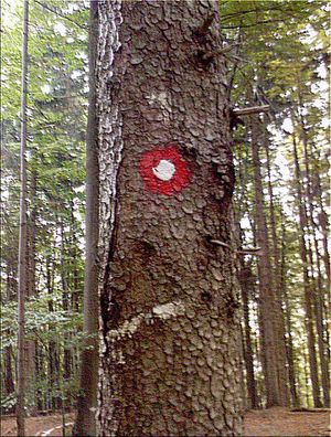
| marked alpine path
(markirana steza) |
highway=path, sac_scale=*, trailblazed=yes, trail_visibility=*,osmc:symbol=*
|
Knafelc blaze: osmc:symbol=red:red_round:white_dot,
blaze for near to country border is | |
| climbing path, secured
(zavarovana plezalna pot) |
highway=path, sac_scale=*, assisted_trail=yes
|
next to it can be safety_rope=*
| |
| climbing path, unsecured
(nezavarovana plezalna pot) |
climbing=*?
|
||
| via ferrata
(športno-plezalna zavarovana pot) |
highway=via_ferrata
|
Vodnik po slovenskih feratah | |
| Slovenian Mountain Trail
(slovenska planinska pot) |
Use relation with ID 6443086. It is marked with tags: | See the example of how the Slovenska planinska pot is tagged from Maribor to Ankaran.
You can load this relation in JOSM by loading road between Mašin žaga and Pesek. see also: 6443086 | |
| European long-distance path
(evropska pešpot) |
see European long-distance paths | ||
| footpaths PP 1 - 7
(pohodne poti PP 1 - 7) |
|||
| carriage road
(kolovoz) |
highway=track?
|
||
| forest (gravel) road
(gozdna cesta) |
highway=track
|
See also
Water Features
| feature (eng./slo.) | element | tags to use | comment |
|---|---|---|---|
| spring
(izvir) |
natural=spring
|
||
| stream
(potok) |
waterway=stream, if does not have a permanent flow also: intermittent=yes
name = name of the stream (if it has a name) |
||
| river
(reka) |
waterway=river (drawn as a way) and waterway=riverbank (for wide rivers, drawn as area)
name = name of the river |
||
| water point
(voda?) |
waterway=water_point
|
||
| waterfall
(slap) |
waterway=waterfall, natural=cliff, height=*, width=*
|
||
| lake
(jezero) |
natural=water, water=lake, name = name of the lake
|
||
| water reservoir
(vodno zajetje) |
landuse=reservoir
|
||
| pond
(kal, ribnik) |
water=pond
|
||
| marsh, swamp
(močvirje) |
natural=marsh
|
See also
Natural Features
| feature (eng./slo.) | element | tags to use | comment |
|---|---|---|---|
| peak
(vrh) |
natural=peak
name = name of the peak ele = peak elevation (in meters) |
there may be also man_made=survey_point
| |
| arete
(špičje) |
natural=arete
|
(ex: 578554875 | |
| cliff
(klif, stena) |
natural=cliff
|
there may be also climbing=*
| |
| bare rock
(skalovje) |
natural=bare_rock
|
||
| scree, loose rock
(melišče) |
natural=scree
|
||
| dwarf pine
(ruševje) |
natural=scrub
|
||
| heath
(vresišče) |
natural=heath
|
||
| shingle
(prod) |
natural=shingle
|
||
| sand
(pesek) |
natural=sand
|
For finer grains (< 2 mm) | |
| cave
(jama) |
natural=cave_entrance
|
||
| alpine pasture
(planina) |
natural=fell
|
||
| forest
(gozd) |
natural=wood and landuse=forest
|
See Forest, landcover=trees
| |
| natural feature of interest
(naravna znamenitost) |
? | ||
| viewpoint
(razgledišče) |
tourism=viewpoint
|
||
| quarry
(kamnolom) |
landuse=quarry
|
Nature Reserve
| feature (eng./slo.) | element | tags to use | comment |
|---|---|---|---|
| national park boundary, outer
(meja narodnega parka, zunanja) |
leisure = nature_reserve
boundary = national_park |
||
| national park boundary, inner
(meja narodnega parka, notranja) |
leisure = nature_reserve
boundary = national_park |
||
| nature reserve boundary
(meja zaščitenega območja) |
leisure = nature_reserve
boundary = national_park |
Skiing
| feature (eng./slo.) | element | tags to use | comment |
|---|---|---|---|
| ski piste
(smučarska steza) |
piste:type=downhill / nordic / sled..., sport=skiing, piste:difficulty=*
|
||
| ski area
(smučišče) |
piste:type=downhill, area=yes, sport=skiing
|
||
| ski route (cross-country)
(smučarska tekaška pot) |
route=piste
|
||
| cable car
(gondolska žičnica) |
aerialway=cable_car
|
||
| chair lift
(sedežnica) |
aerialway=chair_lift
|
||
| drag lift
(vlečnica) |
aerialway=drag_lift
|
||
| material cableway, goodslift
(tovorna žičnica) |
? | ||
| Ski Jump
(smučarska skakalnica/letalnica) |
man_made=ski_jump, piste:type=ski_jump / piste:type=ski_jump_landing, sport=ski_jumping
|
Purposely built, permanent ski jumps (Planica, Domžale, Mostec ...) |
See also
- WikiProject Piste Maps
- Piste Maps and Aerialways
- Example Vogel ski resort from OSM data
Tourism
| feature (eng./slo.) | element | tags to use | comment |
|---|---|---|---|
| mountain (alpine) hut
(planinska koča) |
tourism=alpine_hut
name = name of the hut ele = elevation of the hut (in meters) |
Currently there isn't a separate feature for alpine huts. In Slovenia, the nearest term would probably be tourism = guest_house, but I find it unsatisfactory, maybe we should propose a new tourism = alpine_hut feature? --Breki 20:02, 16 September 2007 (BST). | |
| camp site
(kamping) |
tourism = camp_site
or tourism = caravan_site |
||
| hunting lodge
(lovska koča) |
tourism = hunting_lodge | tourism = hunting_lodge is not official or even proposed, but I think it should be OK to use. We can add a proposal. --Breki 16:54, 3 November 2007 (UTC) | |
| tourist farm
(turistična kmetija) |
tourism=guest_house, guest_house=agritourism
|
||
| hotel | ? | ||
| inn
(gostilna, gostišče) |
? | ||
| inn with lodging
(gostilna s prenočišči) |
? | ||
| wine cellar
(vinska klet) |
? | ||
| wine-shop
(vinotoč) |
? | ||
| wine road
(vinska cesta) |
? |
Historical
| feature (eng./slo.) | element | tags to use | comment |
|---|---|---|---|
| wayside shrine
(kapelica) |
historic=wayside_shrine, religion=christian, denomination=roman_catholic
|
||
| wayside cross
(znamenje, križ) |
historic=wayside_cross, religion=christian, denomination=roman_catholic
|
||
| (large) cross
(velik križ) |
man_made=cross, religion=christian, denomination=roman_catholic
|
||
| church
(cerkev) |
building=church, amenity=place_of_worship
|
||
| chapel
(kapela) |
building=chapel, amenity=place_of_worship
|
||
| cemetery
(pokopališče) |
landuse=cemetery
|
||
| grave yard
(staro/majhno/opuščeno pokopališče) |
amenity=grave_yard
|
||
| monument
(spomenik) |
historic = monument | ||
| castle
(grad) |
historic = castle | ||
| ruins
(razvalina) |
historic=ruins
|
||
| trenches
(vojaški jarki) |
barrier=ditch, description=WWI, disused:military=trench, historic=yes, military=trench
|
Other
| feature (eng./slo.) | element | tags to use | comment | |
|---|---|---|---|---|
| observation tower
(razgledni stolp) |
tourism = observation_tower | see [1]
tourism = observation_tower is not an "approved" nor proposed map feature, but I think it is useful to have it. --Breki 21:08, 22 September 2007 (BST) |
||
| hunting stand
(lovska preža, dvignjena kot je običajno v Sloveniji) |
amenity=hunting_stand, hunting_stand=raised_hide, enclosed with a roof: hide=yes, shelter=yes
|
|||
| car park
(parkirišče) |
amenity=parking
|
|||
| (parkirno mesto) | ||||
| cattle grid
(?) |
highway=cattle_grid
|
|||
| military range
(vojaško strelišče) |
military=range
|
|||
| military area
(vojaško območje) |
military=danger_area
|
|||
| village
(vas) |
place=village
name = the name of the village |
|||
| hamlet
(zaselek) |
place=hamlet
name = the name of the hamlet |
Editing Standards and Conventions
First of all, read the main Editing Standards and Conventions page.
Links And Resources
- OSM-talk: Hiking Trails
- Proposed features: Marked trail
- Proposed features: Trail
- Traces from hribi.net might be useful (contact author)
- Proposed features: Hiking
- Sl:Slovenian Hiking Routes