Talk:Key:barrier
Archives | |
|---|---|
| |
maxwidth vs maxwidth:physical
The page has just been updated to replace maxwidth=* with maxwidth:physical=* in the description template. Is this really an improvement? The signposted width seems a far easier addition for the typical mapper. --InsertUser (talk) 19:58, 8 September 2020 (UTC)
- It seems the user that made this change referred to this line on the maxwidth page for guidance: "Do not confuse the specification of the legally restricted maximum width of vehicles with the specification of a physical width limit via maxwidth:physical=*." So it seems like the question here is: should the maxwidth reflect the legal recommended/enforced width limit or the physical one?--IanVG (talk) 15:05, 24 December 2020 (UTC)
- Edit: What is the exact functional difference between using width and maxwidth:physical? I'm not sure I understand the nuance.--IanVG (talk) 15:10, 24 December 2020 (UTC)
- Correct. maxwidth is a legal restiction. But Barriers are physical limitations. key:width is the size of a object. When you use width in combination with tag:barrier=bollard, is width the width/size of the bollard or is it the width of the highway at this point? --OSMRogerWilco (talk) 08:50, 27 December 2020 (UTC)
- I agree that, where a legal maximum width is signposted,
maxwidth=*is easier to map (and probably more useful) thanmaxwidth:physical=*. Problem is: most barriers I encounter don't come with a signposted max width. In that case,maxwidth:physical=*(physical reality) strikes me as more accurate thanmaxwidth=*(legal restriction). The latter, of course, is more widely used and more widely supported than the former. But we shouldn't tag for the renderer, should we?width=*, in my interpretation, would be the width of the barrier, e.g., the diameter of the bollard. I wouldn't bother mapping that. --SmootheFiets (talk) 21:52, 27 December 2020 (UTC)
Dragon's teeth (fortification)
How would you tag dragon's teeth on Wikipedia ?. There are many of them at the Western border of Germany, see for example: http://www.openstreetmap.org/?lat=50.79446&lon=6.017&zoom=17 (Höckerlinie near Aachen). At the moment they are just marked as tag:historic=ruins, and they aren't rendered nicely. Should we add tag:area=yes? And what barrier type would be appropriate? tag:barrier=block? But these should only be used for nodes. How would you tag a wide strip full of Dragon's teeth? --Head 11:40, 9 December 2009 (UTC)
I suggest tag:military=dragon's teeth or tag:military=antitank block associated with tag:barrier=block and with tag:historic=yes or tag:historic=ruins.
Somebody use simply tag:barrier=tank_trap. See tagwatch
In switzerland, see for example Ligne des Toblerones on Wikipedia.
--Pyrog (talk) 09:02, 14 June 2013 (UTC)
Mine field
I suggest barrier=mine_field used on an nodes or areas to indicate mines of all types. Implies access=no. Super important in post war areas. Suggested rendering: Red area + stylized scull & bones. Possible additional tags: mine_field=personnel or tank. Maybe persumed density of mines or if it has been cleared or not. See also http://en.wikipedia.org/wiki/Land_mine. Gorm 16:58, 21 December 2009 (UTC)
- As land mines (and sea mines for that sake) have no legal usage outside the military, I suggest
military=mine_field--Skippern 18:01, 21 December 2009 (UTC) - Land mines within military zones should not be mapped at all: the zone itself may be tagged with
landuse=military, or in more restrictive countries only asaccess=no. - But not all land mines are within military zones. In fact, most of them in the world have been left over there, and abandoned by militaries, creating a severe danger for the civilian population living there or for visitors.
- So it's OK to tag the
barrier=mine_fieldon nodes where there's a alerting signpost and effectively a barrier on an access road (and visible from the unrestricted area), along withaccess=nofor the dangerous zone itself, or for the way of a dangerous old road that has still not been secured. - Note that some zones may be marked as mine fields with
access=noand something likedanger=mine_field, and still be traversed by using an road accessible to the public, but from which you should not escape to the surrounding fields: in that case you'll need to tag that road withaccess=yesfor such permission, but still withdanger=mine_fieldexpliciting the nature of the danger (because there's won't be signages all along the road, but only on a few points, and not necessarily a very solid barrier or fence all along the road as it could just be a classical water drain). Verdy p 09:04, 12 February 2012 (UTC)
What kind of barrier is a parking block?
These things are sometimes placed across a road that is under construction (or, in the case I'm dealing with, constructed but caught in the housing bubble collapse). What should I tag them as? --NE2 16:15, 10 January 2010 (UTC)
- Strangely, that looks like an extreme case of a
traffic_calming=bumpto me. Alv 22:16, 10 January 2010 (UTC)
- Well, yes and no. It's clearly placed to keep traffic out, not to calm traffic. --NE2 22:27, 10 January 2010 (UTC)
- The image no longer works, but I assume you are talking about parking stops (four inches tall, six inches wide at base, usually four to six feet long). These are sometimes used around here to divide "lanes" for different uses. Like, between road and bike lane, or between bike lane and pedestrian lane. Fearsyth (talk) 15:34, 19 October 2019 (UTC)
Slope, not quite a retaining wall?
What should be used for an artificial slope like here? --NE2 12:37, 8 February 2010 (UTC)
Ladder passing?
There's fence that allows to be crossed by ladders. What tag should I use to map them? --Dejv 12:10, 23 February 2010 (UTC)
- That would be, I believe,
barrier=fencefor the fence, andbarrier=stilefor the ladder. --Gorm 11:48, 4 July 2010 (UTC)
"Kent Carriage Gate" or "Kent Carriage Gap"
Searching "Kent Carriage Gate" with Google results only in OSM pages, searching "Kent Carriage Gap" results in several websites, e.g.
Thus I propose to use "Kent Carriage Gap". Willi2006 09:03, 15 April 2010 (UTC)
They sound rare, and indeed the restricted byways you'd find them on are quite a rare kind of road. There are no instances of them in the OSM database as of now. May I suggest an alternative scheme? Kent gaps consist of bollards, so let's tag as barrier=bollard vehicle=no carriage=yes horse=yes description=Kent Carriage Gap instead of inventing another barrier type. --achadwick 09:49, 14 February 2012 (UTC)
more barriers
- Horse hops / horse stiles
- Motorbike inhibitors
- Horse friendly vehicle barriers
--vsandre 17:00, 4 May 2010 (UTC)
Traffic Island
A traffic island is a barrier for cars, because cars can not turn there.
A traffic island is a barrier for pedestrians, as maybe you'll have to wait for another set of traffic signals.
A traffic island is a barrier for wheelchair drivers, because there are often curbs.
This might be a node (in the middle of a mini roundabout)
or a way (deviding two driving lanes)
or an area (a approximately triangular traffic island at one corner of a crossing, where the traffic turning right has its own lane).
Comments? --Lulu-Ann 15:42, 11 May 2010 (UTC)
- I do not think it is
barrier=*so better usehighway=*orlanduse=*, you can then add other tags like sloped_curbs. --Skyper 16:13, 17 May 2010 (UTC)
- What is your argument? I don't see why I should not be able to add a sloped_curb to a barrier. It is surely no highway, as it is not sensible to route someone around on the outline of the traffic island. It is no landuse, this would only make sense if we had a landuse=street, too. I think it is good as a barrier, because like through other barriers there can be footways leading through. Lulu-Ann
- You can use all
highway=*for closed ways (areas).highway=pedestrian,highway=footwayandhighway=serviceare often used for closed ways. A few month ago, Ævar Arnfjörð Bjarmason suggested on his blog and on talk_en a nice use ofhighway=*with closed ways to outline areas of the footway, bicycleway and even streets. - And I am open for a new
landuse=street. - There is no possibility for a footway to lead through
barrier=fence,barrier=wall,barrier=retaining_wall,barrier=hedge, like it is written on Barrier there has to be a shared node withbarrier=entranceorbarrier=gate. --Skyper 11:11, 21 May 2010 (UTC)
- You can use all
- Or the barrier can be split into two sections, that leave a gap where the footway is - i.e. three nodes. Except for retaining_wall, for which it makes sense to have highway=steps intersecting the barrier way. Alv 14:32, 21 May 2010 (UTC)
Drops as barrier (ha-ha)
I'm looking for some way of representing drops as a barrier, including the ha-ha ([2]) and other sudden drops. Indigomc 21:25, 15 May 2010 (UTC)
- You can tag
barrier=retaining_wall, which is about close. The problem comes with elevation which is not well established in OSM so far. --Skyper 10:27, 25 May 2010 (UTC)- elevation you mean
ele=*orheight=*--Sergionaranja 07:58, 26 May 2010 (UTC)- Sorry, I meant there is no 3d so far and
ele=*is not set every 10 m. --Skyper 14:55, 28 May 2010 (UTC)
- Sorry, I meant there is no 3d so far and
- elevation you mean
Bund barriers used in spate irrigation
During the tracing of Yahoo imagery in the context of the Pakistan floods of 2010, I came across many examples of structures which, after some investigation in Wikipedia, appear to be reservoirs for use in spate irrigation. The barriers which are used for water retention, the earthen mound ridges, are referred to as "bunds", singular "bund" (bund at Wiktionary). Looking in OSM doc, I find this value has not been previously; i.e. barrier=bund has not been put into use. An example of my use for this tag-value pair: 73925583![]() 73925583 . As for rendering, if we want to recycle the most similar barrier type, I would suggest it be rendered using the same line type as
73925583 . As for rendering, if we want to recycle the most similar barrier type, I would suggest it be rendered using the same line type as barrier=retaining_wall; the bumps indicating sidedness would be on the outside of the water retention area. If we want to render this as a new line type, I would suggest the same line format as for retaining wall, but in the blue used to render water. --Ceyockey 01:23, 23 August 2010 (BST)
- P.S. one alternative to
barrier=bundcould bebarrier=embankment, which is used in seven instances according to OSMDoc. --Ceyockey 03:36, 23 August 2010 (BST)- I would say you have encountered a local form of Dykes/Dikes/Levees or Dams rather than
barrier=embankment(I have just written an unofficial proposed definition forbarrier=embankmentin another comment below, my proposal distinguishes embankment barriers from water-dikes as being substantially different structures in appearance and purpose). - Jbohmdk 23:34, 9 June 2013 (UTC)
- I would say you have encountered a local form of Dykes/Dikes/Levees or Dams rather than
barrier=step
I would suggest an extension of value set to include "step", implying access=no for wheelchairs, implying step_count=1, to be used for traffic islands and landuse=grass in urban environments. --Ceyockey 14:03, 25 September 2010 (BST)
- does not
highway=stepssuit you? --Sergionaranja 20:19, 28 September 2010 (BST)- Not if what I'm trying to map is a curb-bounded piece of greenery in the midst of an otherwise flat parking lot. Other suggestions as to how to map this would be appreciated. --Ceyockey 01:21, 29 September 2010 (BST)
Gated access, with personnel

How should we tag gated access to various facilities?
- military bases (armed personnel)
- private property, such as gated communities (security personnel)
- inspection gates similar to customs, such as those that ensure against bringing certain agricultural products (some are in California) but obviously are not customs
maxspeed=0, but anything else?
-- Dandv 01:13, 2 November 2010 (UTC)
- Speaking from past experiences, Military bases and gated communities should be tagged as barrier=(appropriate physical description that fits one of the more commonly-accepted tags) plus access=private on the barrier. If there are units guarding the barrier (security guards, military police, etc.), I suggest this tag: barrier:personnel=yes or barrier:security=yes. --Ianlopez1115 02:05, 2 November 2010 (UTC)
- What is the difference between
access=privateandaccess=no? Key:access says thataccess=nomeans "Access by this transport mode is not permitted, public does not have a right of way." I think this would fit better a military facility than private access, which seems more suitable for company parking lots, for example. Otherwise, when wouldaccess=nobe used? -- Dandv 03:00, 2 November 2010 (UTC)- I think access=no is for when there's literally no physical access (an unmoveable barrier blocks the way). --NE2 17:47, 2 November 2010 (UTC)
- What if vehicles owned by government offices/entities and military vehicles use OSM (or an OSM-based application/service) for routing? access=private is still more appropriate than access=no IMHO. -Ianlopez1115 05:28, 3 November 2010 (UTC)
- I think access=no is for when there's literally no physical access (an unmoveable barrier blocks the way). --NE2 17:47, 2 November 2010 (UTC)
- What is the difference between
Coincident Barriers
It's fairly common for a retaining wall to have a fence or wall at the top of it to keep people from falling over the edge. Should these be tagged as barrier=retaining_wall;wall or as two different ways? --Hai-Etlik 07:57, 17 January 2011 (UTC)
Entrance
See also Talk:Proposed features/entrance where some small discussion of barrier in the context of entrance has ensued. --Ceyockey 13:11, 31 October 2011 (UTC)
No door?
The tag "barrier=gate" seems not appropriate for an opaque door, which would allow/restrict access through a wall, while it is not possible to see through. Do you agree the tag barrier=door or am I missing some existing tag? Teuxe 12:09, 1 May 2012 (BST)
soil barrier / Earth Wall?
- I think your links are referring to the barrier type known as an Earth Wall (There is no appropriate English Wikipedia article for this), that is a barrier formed by piling up Earth to form an long narrow artificial hill, like an upside-down ditch. Unlike the old link to the archeology page about historic earthworks, earth walls are still being built as barriers, primarily as sound barriers along noisy roads. For example here is a newspaper photo of one built in 2001.
- Despite the inclusion of the word "wall" in the English name of this barrier type, it has little similarity to a wall and is not so named in many other languages. The form of barrier I am thinking of generally has no wall, palisades or other significant barrier structure on top. It is like a dyke without water. And is often covered in light vegetation such as grass, bushes or young trees. Flowers are occasionally added for decoration where budgets allow.
- The one example I could fine in non-English Wikipedia: Landweer (nl) (second photo, not the drawing that includes two ditches), the word in Danish is "vold" (second dictionary meaning, not the one with a Wikipedia article).
- Jbohmdk 23:53, 23 May 2013 (UTC)
- After some more searching and browsing, I have come to the conclusion that the most appropriate tagging would be "barrier=embankment", and I have some ideas about how to define and clarify the various embankment tags in different categories, however the current "proposal" process seems to be too much work for an occasional mapper like me (It assumes the proposer will work the process like 20 hours/week for months or years).
- So here are (without fancy templates), my proposed definitions:
- On osm, an embankment is an artificial (man-made) long narrow "hill" which outwardly appears to be made mostly of soil, sand etc, but may or may not be internally strengthened with other materials. Unless otherwise tagged embankments are symmetrical, i.e. the surrounding land is at about the same level on both sides and a single way tagged as an embankment is assumed to rise steeply from the surrounding land on both its left and right. All embankments tags are applied to ways, which track the approximate center line of the top of the embankment.
- Embankments have been built since prehistoric times and are still being built whenever needed, since they tend to be a cheap way to get the desired functionality, which may be anything from fortifying a military compound to just needing a pretty use for the excess soil from digging out a school basement.
- In accordance with the principle of mapping what is visible "on the ground", embankments are tagged according to the first of the following tags which describe its relationship with other objects:
embankment=yesAnother linear feature, such as a road, railway, canal, fence, wall etc. runs on the top of the embankment and the embankment looks like its primary purpose is to keep that other feature at a desired level above the surrounding land. To map this, draw the way that is at the top of the embankment and then addembankment=yesto that way, similar to how you would addbridge=yesif it was running on top of a bridge. Because this is an attribute of another feature, it may be used even if the embankment rises as little as 0.5m/2feet above the terrain, though it would mostly be used if the height is greater for most of the affected length. On paper maps this attribute is traditionally rendered as a line along each side of the way with short perpendicular lines outward from each to symbolize the steep slopes down to the regular surface, and this also seems to be how some OSM-based renderers draw it.
- Dike/Dyke (proper tag unknown and possibly undecided by the project). The embankment has been erected to stop water from getting from one side to the other. The water may be always there or only during floods. The most famous example are the massive dikes which allows Holland (part of the Netherlands) to function as dry inhabitable land even though it is mostly below sea level and was formerly part of the seabed of the Atlantic Ocean. (Note that some of the famous Holland dykes do in fact carry roads or canals on top and thus might be tagged accordingly). Someone else has made at least one proposal for these, and my proposal is not intended to conflict with them nor to endorse them.
barrier=embankmentplusembankment=yes(This is the only thing intentionally new in this proposal): The embankment stands on its own with nothing on top (except perhaps vegetation and/or a narrow unofficial walking path) and serves primarily as a barrier for anything other than water that might wish to cross it, including sound in the form of traffic noise. As a standalone map feature, it should be drawn only if it is at least 1.2m/4feet tall for most of its length. As with other barriers, openings may be tagged as points without splitting the drawn way in two. It is suggested that renderers draw this the same way as other ways with theembankment=yestag, but with either no extra symbol for the stuff not on top of it or a generic barrier symbol, where an opening is tagged as a point on the barrier way, rendering of the embankment decoration should be interrupted to show that passage is generally at ground level even though this is not explicitly tagged. Routing algorithms should simply treat it like any other impassable barrier (such asbarrier=fence) with the same possibility that gates and other openings may allow passage at designated points. --Jbohmdk 20:29, 9 June 2013 (UTC)
barrier=embankmentseems to be widely used now (taginfo rank #27). Shouldn't it be added to the main page? --GerdHH (talk) 08:34, 4 October 2017 (UTC)
- We have a lot of these in Ireland (photos available on request). Going to map at least some of them based on this approach but worth noting that ID now complains if you use
barrier=embankment. 00 --Dónal (talk) 15:19, 26 August 2020 (UTC)
- We have a lot of these in Ireland (photos available on request). Going to map at least some of them based on this approach but worth noting that ID now complains if you use
- I guess the appropriate access rule would be
access=no/foot=yes. But what about the junction node, where a path crosses an embankment? It sounds crazy to map it asbarrier=entrance, if there is no opening at all. Or simply repeat thebarrier=embankmentfor the node, combined with explicit access rules, to make the barrier effective for routing?--GerdHH (talk) 09:27, 4 October 2017 (UTC)
- I guess the appropriate access rule would be
Remove Rendering column
I propose to remove Rendering column. Renderings are renderer specific and should be discussed on their own page. And some images are not meaningful as they were generated with the now unmaintained Osmarender. --Oligo (talk) 19:28, 15 July 2013 (UTC)
- I agree. If rendering examples are deemed useful, then I would prefer adding them to a gallery on the tag pages (e.g.
barrier=bollardwhich already has two such examples). This would allow for adding more than one renderer. --Tordanik 23:55, 15 July 2013 (UTC)
- This would be better discussed at Talk:Map Features -- note that the majority of tables have a single Rendering column. --goldfndr (talk) 01:41, 16 July 2013 (UTC)
handrails
How to map handrails? If is very often around stairways. --Jakubt (talk) 00:48, 24 January 2014 (UTC)
- See Key:handrail for handrails. --Tordanik 16:26, 24 January 2014 (UTC)
noise_barrier
I noticed that we do not have a tag to describe acoustic screens located along streets or roads. What kind of a name for the tag would be the best to describe these screens? --Władysław Komorek (talk) 11:32, 14 August 2014 (UTC)
- There's a tag documented:
barrier=wall,wall=noise_barrier--HeikoE (talk) 08:16, 15 August 2014 (UTC)
barrier=dog

In Greece they love to chain dogs at the side of a road, preferably one on each side. If the dogs are fierce enough, this virtually stops any sheep or hiker to pass, while vehicles can cross the barrier without problems (Cf.: Crete). How can we tag this? --GerdHH (talk) 14:56, 28 October 2014 (UTC)
- Haha! :)--Jojo4u (talk) 18:36, 25 March 2015 (UTC)
- Bow Bow! Grrrr :-( --GerdHH (talk) 19:03, 13 June 2023 (UTC)
- This is an example from the Inner-German border: 919856252
 919856252 (also note the photo above).
 barrier=fenceis obviously nonsense here, because it's not a fence, but a cable where a dog had been attached to (note the kennel). Another type were dogs running between two fences. The "Greek type" (dogs at each side of a road - unfortunately still no photo) is a third one. Therefore I would propose a more general tag for all kind of constructed dog barriers, but of course not applying for every dog on any property. --GerdHH (talk) 19:03, 13 June 2023 (UTC)- Google has just told me that a "dog barrier" is used to keep dogs inside your property, i.e. stopping dogs, not man or sheep. Maybe a native speaker knows a better expression? --GerdHH (talk) 19:22, 13 June 2023 (UTC)
barrier to block cars but allow bicycles to pass
How to tag barrier that blocks wide vehicles but allow bicycles (or probably also motocycles) to pass? See the picture.
 --*Martin* (talk) 21:04, 27 March 2015 (UTC)
- I guess Tag:barrier=cycle_barrier with the appropriate access tags is the best fit. --Jojo4u (talk) 21:31, 27 March 2015 (UTC)
Gates that open sideways
Which barrier=*_gate should be used to gate where the obstable part is moving sideways (not lifting nor swinging)? barrier=shift_gate? -- Ij (talk) 19:06, 14 September 2015 (UTC)
Photo sensor
How to map a sensor barrier? Something that counts vehicles or triggers an alarm, usually found to protect properties in a discrete way. Sometimes they are complimentary to a another barrier, for example to alert a guard down the road that a vehicle is approaching. - Panoramedia (talk) 11 October 2015 04:23 (unsigned)
- Is it a barrier or does it just monitor?
man_made=surveillancecould be used. The RedBurn (talk) 09:55, 20 July 2019 (UTC)
Access through barriers - legal or technical?
When there is a barrier with an access tag, does that access tag refer to the ability of passage for a particular type of traffic or what is legally allowed? For example for a gate on a track that you can legally walk through, but not legally (only technically) drive through, should it be tagged with 'foot=yes' and 'motorvehicle=yes' or 'motorvehicle=no'? --Abc26324 14:35, 15 December 2015 (UTC)
We usually tag the legal restriction if it is known. --Hedaja (talk) 19:29, 2 March 2016 (UTC)
- I think what is usually done is to tag the combination of both. It certainly is not just the legal restriction. If you can't drive around a bollard, then it's motorcar=no, even if there is no sign or anything visible. --Tordanik 22:12, 2 March 2016 (UTC)
barrier=animal_gate
I had a discussion regarding special gates for animals (for example in enclosures). I'd like to document the new tag barrier=animal_gate. and the gate:type=guillotine.
If no one has any objections, I would make a wiki page for animal_gate and gate:type.
Cheers --Hedaja (talk) 19:26, 2 March 2016 (UTC)
Glass Wall
I have faced with the problem of mapping glass material wall (like this). How to map this? Santamariense (talk) 02:54, 3 May 2016 (UTC)
- Looks like some type of fence to me. There are 30 occurences of
barrier=fence+fence_type=glass.--Jojo4u (talk) 07:35, 3 May 2016 (UTC)
'Bus gate'
In Aberdeen, Scotland, a 'bus gate' has recently been added. This is simply a narrowed area of the road with a road sign indicating that legal access is only for busses. It may soon have CCTV enforcement. There is no physical barrier. At first I thought to split the road with a very short way with appropriate access tags but that doesn't seem like a great plan (not explicit enough), so now I've mapped it as a barrier=gate. This also seems slightly misleading as this implies a physical barrier that doesn't exist. Any ideas? Here's the barrier on the map, and here's a picture of the bus gate in question. Spark (talk) 22:40, 9 June 2016 (UTC)
- In my opinion if there is not a barrier, you should not map it as a barrier. Just split the way and put the appropriate access tag. It can be useful if you can also map the traffic sign. -- AnyFile (talk) 19:58, 10 June 2016 (UTC)
- Thanks, the problem with splitting the way is that there is no access restriction on either side, cars can drive right up to the 'gate' from either side, they are just not allowed to pass through it. So if I was to split the way I'd end up with an unmanageably tiny way with the access restrictions on it. This doesn't feel right, and the distances are too small to map accurately. Spark (talk) 21:56, 10 June 2016 (UTC)
- Why 'unmanageably tiny'? I don't think there's any problem with a tiny way as you describe. True, distances can't be that accurate, but probably accurate enough for all practical purposes. There's a facility somewhere to 'measure' the length of an OSM way in m/km, etc., which should get you close enough, but imo if cars are told by the map that the bus gate is 10m longer than it actually is, that's really no biggie. Alternatively, how about a point-object barrier=yes or barrier=traffic_island and then the appropriate tags? Will routers deal with that ok? They certainly seem to turn around at barrier=bollard when that is on one of the nodes of a highway eteb3 (talk) 11:09, 7 October 2020 (UTC)
- Thanks, the problem with splitting the way is that there is no access restriction on either side, cars can drive right up to the 'gate' from either side, they are just not allowed to pass through it. So if I was to split the way I'd end up with an unmanageably tiny way with the access restrictions on it. This doesn't feel right, and the distances are too small to map accurately. Spark (talk) 21:56, 10 June 2016 (UTC)
One-Way Spikes?

Hey, I was just wondering how to properly tag spikes like those shown on the right. Would it be barrier=spikes + oneway=yes, or possibly barrier=one-way spikes, or maybe something else I haven't thought about? Either way, I believe this ought to be added to the main page, as this kind of barrier is pretty common, at least where I live in North Texas.
--UltimateRiff (talk) 06:03, 9 August 2017 (UTC)
barrier=spikesseems to be well accepted, I'm not aware of a non-contentious way to indicate one-way on a node. I think some QA tools flag it as an error (just saw a few get remoed in an area I'm familiar with). --InsertUser (talk) 09:55, 21 August 2020 (UTC)
Raised median, cable fence

How would one tag these two types of barriers?
At the entrance to the bicycle/pedestrian trail, there's a raised median which prevents low-clearance cars from entering but allows fire trucks through. Suggestion: barrier=raised_median.
Next to the trail is a simple fence made of a single steel cable supported by short wooden poles, discouraging access to protected areas. Suggestion: barrier=fence fence_type=cable.
--T99 (talk) 06:31, 30 October 2017 (UTC)
- For the first example
barrier=sump_buster--InsertUser (talk) 12:05, 27 August 2020 (UTC)
Adjacent (parallel) barriers
Hi there - newbie here. I find it useful when OpenStreetmap has stiles, gates and other barriers, so I thought I'd "pay it back" and add some. Today I encountered a rail trail that had three different barriers, side by side, where it met a road: a cycle barrier on one side, a gate (locked) in the middle, and a horse stile on the other (Google Streetview). How would I map this? Create three ways at the very end of the trial, each joined to the road, and put a barrier on each of them? Thanks Dave.Dunford (talk) 20:17, 30 September 2018 (UTC)
Visibility of stiles (and other non-gates) on map
Having had no response at Talk:Tag:barrier=stile I thought I'd repeat my query here.
- So am I right in thinking that gates are shown on the main map as a visible symbol, but stiles aren't? Less mobile walkers, and those with dogs, find it useful to know where paths have stiles, and I have been adding some (e.g. node 4505413763) following recent outings, but it seems a bit pointless if they don't appear as a visible symbol on the map and you only know that they're there if you use Query Features. Am I missing something? Is it easy to add a symbol? User:Chrisana13 suggested one at Tag:barrier=stile#Possible Rendering. Dave.Dunford (talk) 12:46, 2 October 2018 (UTC)
- The addition of an icon for stiles is currently being discussed on GitHub (and reading the recent posts over there, you may have already discovered that link :)). --Tordanik 15:24, 23 October 2018 (UTC)
- Indeed. Seems it's imminent. Thanks for replying. Dave.Dunford (talk) 16:30, 23 October 2018 (UTC)
Missing barrier type: crowd_control
I need a node tag for a barrier like this: [4] which blocks access for everyone but could be removed easily. What would be a proper name? --Ordoviz (talk) 16:00, 31 May 2019 (UTC)
Electrified barriers
Anyone know if there is a way to tag electrified barriers? There's an electrified=* tag already being used, but it seems to be used only for rail and isn't suppose to be added to nodes. --Adamant1 (talk) 04:11, 30 June 2019 (UTC)
- I used electrified=yes when I added an electric cattle grid a few years ago. https://www.openstreetmap.org/node/370443559. Mark P. (talk) 12:37, 10 October 2019 (UTC)
Neither a Fence nor a Handrail
Here's a barrier we have around our Main Public Library building in Portland, OR - picture below. I went over the options already defined above and can't see any that would apply. Please, suggest how to map it.
- Looks like a balustrade. There aren't a lot of them in the OSM database yet, but the most common tagging appears to be
barrier=fence+fence_type=balustradeaccording to Taginfo's statistics. --Tordanik 17:59, 17 January 2020 (UTC)
Never on water?
The page states "The barrier tag only covers on-the-ground barriers. It does not cover typical waterway barriers (dams, waterfalls, etc.)."
This seems too doctrinaire and excludes an important water barrier, a boom. I would propose this is reworded as follows:
The barrier tag covers man-made barriers that are intended to stop people passing where they otherwise could go. (Also animals, objects, etc.) A feature which stops them only as an unintended side-effect of its function (e.g., a dam) should probably not be included here.
Anyone support, object, or suggest? eteb3 (talk) 10:49, 7 October 2020 (UTC)
- The text is currently correct, since barrier=boom is quite rare. Perhaps it would be better to use
waterway=boomorman_made=boomto map the floating booms instead. --Jeisenbe (talk) 06:13, 8 October 2020 (UTC)
- Why do you think those tags might be better? eteb3 (talk) 10:46, 8 October 2020 (UTC)
- On second look,
waterway=boomwas a bad idea - that tag hasn't been used, andwaterway=*is for major parts of a watercourse like waterfalls, dams and weirs. Butman_made=boomhas been used 29 times on ways (https://taginfo.openstreetmap.org/tags/man_made=boom) which is about equal to the use ofbarrier=boomon ways (https://taginfo.openstreetmap.org/tags/barrier=boom). Since, as you've noted, the other uses ofbarrier=*are for obstructions on roadways, paths, railways, and other land features, it might be better to useman_made=*for booms. --Jeisenbe (talk) 17:37, 8 October 2020 (UTC)
- On second look,
- But it turns out, the most common way to map booms is with the complicated
seamark=*tags: https://taginfo.openstreetmap.org/tags/seamark%3Aobstruction%3Acategory=boom - there are 265 ways withseamark:obstruction:category=boom. I wouldn't really recommend this tag since it is excessively complicated, but it's worth noting that this is the most common one so far (though most of the use is in the Netherlands). --Jeisenbe (talk) 17:41, 8 October 2020 (UTC)
- But it turns out, the most common way to map booms is with the complicated
- Also
waterway=floating_barrierhas been used 104 times, mostly in England: https://taginfo.openstreetmap.org/tags/waterway=floating_barrier
- Also
- I documented your tag at Tag:barrier=boom and the alternative at Tag:waterway=floating_barrier. Please make a proposal if you want to get one of the two approved and the other deprecated. --Jeisenbe (talk) 05:23, 11 October 2020 (UTC)
- Thanks. I've now had a chance to look at those. The pages are rather different: it seems parts of my draft have gone into barrier=boom and other parts into waterway=floating_barrier. As both tags represent the same object, it would seem they should have the same write-up and I'd propose to make them equivalent. Any thoughts on that? eteb3 (talk) 15:57, 20 October 2020 (UTC)
Barrier connected to Closed Ways
Couldn't find if this point was already addressed/obvious, but if there is a barrier=fence that surrounds a landuse, for example landuse=grass, would I connect all the nodes of the barrier=fence to the landuse closed way? Is there consensus on this issue, and are there any special cases that would be cause for mapping it otherwise? Thanks!--IanVG (talk) 16:32, 16 October 2020 (UTC)
- Is this area reaching the barrier or is there something between fence and grass? If there is no gap then attaching is fine Mateusz Konieczny (talk) 07:15, 20 October 2020 (UTC)
- No there is nothing between the landuse I have in mind in between to the barrier- I'll go ahead and attach the barriers in mind to the landuse (in my case is grass). And just as I am curious, what, generally speaking, would constitute a 'gap'? Any specific cases that anyone could point to clarify this point? And thank you Mateusz Konieczny!--IanVG (talk) 18:24, 22 October 2020 (UTC)
- Gluing road lines to
landuse=residentialareas is a common mistake (residential area is basically never including half of the road, up to the centerline AND mapping in such damaged area is irritating AND it is time-consuming to fix). Other common mistake is gluingnatural=woodand lake while tree-covered area and water area has gap. Mateusz Konieczny (talk) 07:13, 23 October 2020 (UTC)- Okay, thanks for the help. So for the example of the tree-covered area and water area, the 'gap' in this case would be filed in by something like natural=swamp or =marsh?--IanVG (talk) 15:13, 24 December 2020 (UTC)
- Gluing road lines to
- No there is nothing between the landuse I have in mind in between to the barrier- I'll go ahead and attach the barriers in mind to the landuse (in my case is grass). And just as I am curious, what, generally speaking, would constitute a 'gap'? Any specific cases that anyone could point to clarify this point? And thank you Mateusz Konieczny!--IanVG (talk) 18:24, 22 October 2020 (UTC)
Confusion on Kerb Barrier
Looking at the description for the kerb barrier and I'm wondering what the author intended when they wrote: "Right side is bottom, left side is top". When it looks to be the exact opposite. I don't want to change this, as there must be some rhyme or reason, but could anyone enlighten me as to the function of that sentence?--IanVG (talk) 14:56, 24 December 2020 (UTC)
- It's correct: like
natural=cliff,man_made=embankmentandnatural=coastline, the low side is on the right hand side of the way. This might be on the left hand side of your computer screen if the way is heading north to south, but it will be on the left side of your screen when the way is going from south to north. --Jeisenbe (talk) 16:21, 24 December 2020 (UTC)
- Thanks @Jeisenbe:! So for the picture located in the next to this description, (which shows the bottom of the curb on the left and the top of the curb on the right), the way should be drawn from top to bottom? Would it be a good idea to add that little piece of advice to the page? I certainly would have been less confused. Thanks again! --IanVG (talk) 16:42, 24 December 2020 (UTC)
- Probably it would be best to pick a different example image. Perhaps you could upload one from a screenshot in JOSM or iD? --Jeisenbe (talk) 17:56, 24 December 2020 (UTC)
- Yes! I can do that, I’ll upload it when I can.--IanVG (talk) 03:46, 27 December 2020 (UTC)
width_restrictor


![[4]](https://commons.wikimedia.org/wiki/File:Friedrichs_model_SF-1_crowd_control_barricade.gif)
We have barrier=height_restrictor, but no corresponding barrier=width_restrictor. Should there be both? The closest equivalent is perhaps traffic_calming=choker, but that seems more focussed on road-speed reduction rather than enforcing a width limit. Markus Kuhn (talk) 16:05, 15 April 2025 (UTC)
- Can't tell from your examples. It should be
traffic_calming=choker, only unless it's signposted for restricting widths? Such restrictors are often narrower than the road's physical width. - —— Kovposch (talk) 20:32, 15 April 2025 (UTC)
- The maximum vehicle width allowed on roads in the UK (for example) is 2.55 m (2.60 m for refrigerated vehicles with insulation), and a
traffic_calming=choker(like the one shown on the right photo) is generally wide enough to allow all legal vehicles (even a 2.5 m wide lorry or fire engine) to pass safely. A width restrictor (like the 2.0 m one shown on the left photo) enforces a width limit narrower than the width of the widest allowed road vehicle, and therefore, unlike a traffic-calming choker, is of higher relevance to routing. SUV/Truck/lorry map users may want width restrictors to be displayed more prominently than traffic-calming chokers, as not every vehicle will get through the former. The purpose of these two devices is different: one filters vehicles, the other just discourages speeding. Markus Kuhn (talk) 09:58, 17 April 2025 (UTC)- Ok you didn't explain the difference between the 2 examples. How would you distinguish such a device on those narrow local roads, where it could be correspondingly narrower though? Is there really no signage? If you rely on knowledge of the law, and actually measuring it (when the aerial imagery is not clear and accurate enough) or human width perception, there's a higher risk of misuse. Especially
traffic_calming=chokeris already showing it now, so it would need to be changed, and any existing ones re-tagged. Tag:traffic_calming=choker#Photo_examples
—— Kovposch (talk) 05:15, 18 April 2025 (UTC)
- Ok you didn't explain the difference between the 2 examples. How would you distinguish such a device on those narrow local roads, where it could be correspondingly narrower though? Is there really no signage? If you rely on knowledge of the law, and actually measuring it (when the aerial imagery is not clear and accurate enough) or human width perception, there's a higher risk of misuse. Especially
- The maximum vehicle width allowed on roads in the UK (for example) is 2.55 m (2.60 m for refrigerated vehicles with insulation), and a
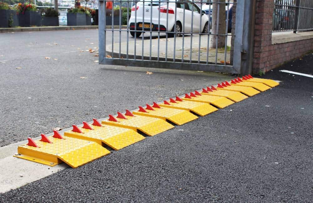
Alligator Teeth (directional)
I there a reason the barrier, commonly called Alligator or shark teeth, which prevents vehicles from access, but only in one direction, isn't listed?
https://breezemount.net/wp-content/uploads/2020/09/Alligator-Teeth-7-1.jpg?id=1913