Key:footway
 |
| Description |
|---|
| Further refinement of footways |
| Group: highways |
| Used on these elements |
| Documented values: 15 |
| Requires |
| Status: approved |
| Tools for this tag |
|
The key footway=* refines the tag highway=footway.
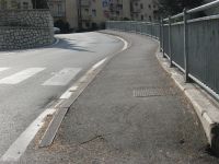
The two most common values are footway=sidewalk for sidewalks (called pavement or footpath in British English; see Sidewalks as well for a more in-depth treatment of this topic) and footway=crossing to mark parts of a pedestrian path that cross a road.
It is also used together with highway=path in some communities where it represents a refining of the pedestrian part of a combined or segregated foot- and cycleway; for this use see also the comprehensive explanation for bicycle way tagging.
Common values
Less Common or deprecated values
| Key | Value | Element | Description | Photo | Count |
|---|---|---|---|---|---|
footway=*
|
chemin_de_ronde | It represent a chemin de ronde (French for "round path"' or "patrol path", a.k.a. an "allure", "alure", a "wall-walk", "guard-walk") for traversing a city, castle, and fortress walls. This path is a raised protected walkway behind a wall=castle_wall, historic=citywalls, barrier=city_wall battlement, or simple parapet. Today, it is a feature of medieval fortifications of high tourist interest.
|
 |
||
footway=*
|
lane
|
One of the options to map pedestrian lane (i.e. part of the carriageway dedicated for pedestrian traffic, only marked with paint and not separated by kerbs, treeline or other physical barriers). See Sidewalks#As a pedestrian lane on the road for a list of alternative options, as well as problems with this one! | 
|
| |
footway=* |
both / right / left / none / no / separate |
Usage for sidewalks
To start using this tag, map the sidewalk as a way alongside the carriageway, with the following tags:
You might use additional tags:
incline=*kerb=*wheelchair=*smoothness=*surface=*tactile_paving=*width=*/est_width=*
Connecting ways
Connections of other ways with to the street should always be made as in reality: If a way terminates on the sidewalk don't map a connection to the carriageway. If a way goes over the sidewalk to the carriageway just draw the way trough to the carriageway with a shared node on the sidewalk way.
The latter also holds true for connecting highway=footway/path: The access permissions for sidewalks usually don't allow other access than pedestrian and without the connection routing might be broken. If a way allowed for bicycles terminates on a sidewalk consider adding bicycle=dismount for the shortest sidewalk route to the carriageway.
Access
If walking is illegal on a road then use foot=no (or foot=use_sidepath, if appropriate) given that most roads are assumed to be available for use by pedestrians unless they are motorways. For motorways consider adding foot=yes if walking is allowed, and add a sidewalk=* with the appropriate value. See access=* for a more general discussion about legal access issues.
Usage for crossings
The process is as follows:
- On either side of the street, create a parallel
footway=sidewalk way, if any
 - Create a perpendicular way (connecting both sidewalks) with
highway=footwayandfootway=crossing - Place a
highway=crossing node at each point where this perpendicular section crosses the carriageway (often only one point, more for a dual carriageway or complex junction).
You might use additional tags:
incline=*kerb=*wheelchair=*smoothness=*surface=*tactile_paving=*width=*/est_width=*
See also crossing:island=* and footway=traffic_island if you wish to map the presence of pedestrian refuges along the crossing.
Where there's no sidewalk on the opposite side but where the crossing is used to access a park, playground, building entrance, service road. etc., draw the perpendicular footway from the sidewalk footway to the crossing node on the carriageway.
Add cycleway=crossing if the crossing can be used by cyclists without dismounting, however where cyclists are required to dismount then add bicycle=dismount) to indicate that the route can be used by cyclists on foot.
Examples
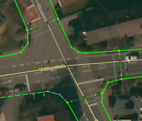
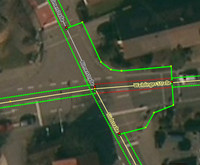
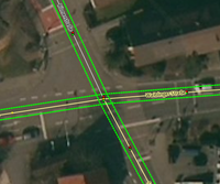
The following examples show the range of sidewalk/crossing mapping of an intersection from very detailed to less detailed.
| Image | Discussion |
|---|---|
| Example for tagging as separate way | |

|
|
| Example for combination of tagging as property and as separate way – full crossing & kerb mapping | |

|
|
| Example for combination of tagging as property and as separate way – light crossing & kerb mapping | |
| |
| Example for tagging as property | |
| |
Association with the street
Because mapping sidewalks as separate ways disconnects them from the associated street, several methods have been proposed to link the separately mapped sidewalk back to the street. None have universal acceptance.
name
Sidewalks are usually left unnamed in OpenStreetMap, but some mappers prefer to use name=* to associate a sidewalk with a street, avoiding the complexity of a relation. Around three to four percent of ways with footway=sidewalk have name=* set as well (amounting to 125,000 as of August 2022, and 230,000 as of October 2025). Some applications can handle such attributes on a footway=sidewalk differently.[1]
As of October 2025, name=* on sidewalks has about 230,000 uses worldwide[2], an unknown amount of which might be dedicated names like "Hollywood Walk of Fame". They are particularly used in Montreal[3] and parts of London and Manchester[4].
Some mappers debate whether a sidewalk "has a name" like vehicle carriageways do[5], and what to tag when the sidewalk does not have "its own name". See Talk:Tag:footway=sidewalk#Name tag on the sidewalk for example.
is_sidepath
The Proposal:Key:is_sidepath proposal captures whether a path is parallel along a street, making it adjoining.
The Proposal:Key:is_sidepath:of proposal provides a way to specify which street the footway is a sidewalk of.
The values are normally the type of the associated street, e.g. is_sidepath:of=residential.
More specific information can be provided with is_sidepath:of:name=* and is_sidepath:of:ref=*.
As of October 2025, there are 30,000 global uses of is_sidepath:of:name=*, 15,500 of them on footway=sidewalk.[6]
Some mappers find is_sidepath:of:name=* unwieldy or contrary to usual key naming practices.[7]
As of January 2025, this tag is now supported by cycle.travel for providing names while routing.[8]
street:name
street:name=* has been used to associate sidewalk ways with their street names, by analogy with bridge:name=* and tunnel:name=*. As of October 2025, there are about 9,100 uses of it on sidewalks. [9]
Some mappers find street:name=* unfortunate because there is no related street=* tag.[10]
As of January 2025, this tag is now supported by cycle.travel for providing names while routing.[11]
associatedStreet or street relations
type=street
|
|---|
type=associatedStreet
|
To couple the sidewalk to its respective street, the ways can be added to a relation of type associatedStreet or of type street. The former was originally created for linking houses to the street whose name is used in their address, rather than the street they are physically accessible from or nearest to. The latter was conceived to bind all parts of a street together — e.g. multiple segments of the roadway. The roles listed in the following table are compatible with either type of relation, though type street has gradually become more popular for sidewalks.
| Element | Role | Recurrence? | Discussion |
|---|---|---|---|
street or <empty>
|
One or more | The multiple ways that form the carriageway | |
sidewalk
|
One or more | The multiple ways that form the sidewalk and the crossings |
Using relations for this purpose is very much optional, and you may wish to omit this in order to keep your mapping simple.
According to the Taginfo statistics[12], as of October 2025 over 7,500 ways were connected with role sidewalk to such relations; 4200 of them to relations of type street, and around 3400 to relations of type associatedStreet.
Other
Proposal:Relation:street, Proposal:Street, and Proposal:Collected Ways would all group the elements that form or relate to the street, including any sidewalk ways. Proposal:Sidepath tagging scheme would use tags on ways to make the related street more discoverable, without referring to it by name.
For lack of a community consensus on the correct key to use, the OpenSidewalks team used to recommend putting the street name in description=* before 2025.[13]
There are requests for OpenRouteservice and Valhalla to automatically infer street names when following sidewalks. Sidewalk Sidekick is a proof of concept for how a navigation application might use map matching to automatically enrich pedestrian routes with parallel streets' names on the fly.
Possible tagging mistakes
See also
- Sidewalks
sidewalk=*– for mapping sidewalks as refinement to a highway- Proposed features/Sidewalk as separate way – approved proposal for this key
References
- ↑ For example, SomeoneElse-style not rendering
nameon sidewalks - ↑ Taginfo
- ↑ Taginfo for Quebec shows 80,000
footway=sidewalkwithname=*, making about three-quarters of all sidewalks there - ↑ Taginfo for Great Britain shows 14,000
footway=sidewalkwithname=* - ↑ Discussion in January 2025
- ↑ Taginfo for footway=sidewalk combinations, searching for
name - ↑ Discussion in German forum in 2024
- ↑ Announcement
- ↑ Taginfo, once uses on
parking=*are excluded - ↑ Discussion in German forum in 2024
- ↑ Announcement
- ↑ Taginfo search for
sidewalkin roles - ↑ Github discussion
| ||||||||||||||||||||||||||||||

