Template:Bs:Map Features:man made
Jump to navigation
Jump to search
Template for the 'Man Made' table in the Map Features page. Use the default English text or use the template arguments for your translations
==Usage==
All parameters are optional. By default, text is in English.
English writers shall write their comments in the template itself (avoiding double edition).
Other languages are translated in template arguments, not in the template itself.
== section header ==
|name=        (section header line)
|description= (displayed before and/or after the table; optional)

== One key/value row ==
|man_made:key=   |works:value=   |works:desc=   |works:render=   |works:photo=

}}
Ljudske tvorevine
| Key/Ključ | Value/Vrijednost | Element | Komentar | Rendering | Slika |
|---|---|---|---|---|---|
| man_made | adit | A type of entrance to an underground mine which is horizontal or nearly horizontal. |  | ||
| man_made | advertising | A generic advertising device. |  | ||
| man_made | antenna | An antenna to transmit and/or receive wireless signals. |  | ||
| man_made | avalanche_protection | A feature to protect from avalanches or to keep them from going off. |  | ||
| man_made | beacon | Pomaže pomorcima u navigaciji |  | ||
| man_made | beehive | Beehive |  | ||
| man_made | borehole | A bore used for a purpose not covered by man_made=petroleum_well or man_made=water_well.
|
 | ||
| man_made | breakwater | A man-made structure designed to protect a shore or harbour from the sea and waves. |  |
 | |
| man_made | bridge | The outline of a bridge, grouping together all features for that bridge.
Please also add |
 |
 | |
| man_made | bunker_silo | An open-sided structure that can be used with vehicles to fill and empty them. |  | ||
| man_made | cairn | A mound of stones, usually conical or pyramidal, raised as a landmark or to designate a point of importance in surveying. |  | ||
| man_made | carpet_hanger | A construction to hang carpets for cleaning with the help of carpet beaters. |  | ||
| man_made | cellar_entrance | An entrance into artificially created vault. |  | ||
| man_made | charge_point | A device for charging electric vehicles. |  | ||
| man_made | chiller | industrial cooling construction with large diameter fans |  | ||
| man_made | chimney | A tall distinctive vertical conduit for venting hot gases or smoke, normally found near power stations or large factories. |  | ||
| man_made | clarifier | A clarifier of a wastewater treatment plant. |  | ||
| man_made | clearcut | An area where all trees have been uniformly cut down. |  | ||
| man_made | column | A column used to support a structure or for decoration. |  | ||
| man_made | communications_tower | A huge tower for transmitting radio applications. |  | ||
| man_made | compass_rose | A compass rose or wind rose. |  | ||
| man_made | compressor | Industrial equipment used to compress a gas by reducing its volume. |  | ||
| man_made | cooling | Industrial cooling facility. |  | ||
| man_made | cooling_tower | A cooling tower |  | ||
| man_made | courtyard | An area that is usually enclosed by walls or buildings. |  | ||
| man_made | crane | Kran, stacionarni kran, kao u lukama |  | ||
| man_made | cross | Cross with little historical or religion value, e.g. summit cross. |  | ||
| man_made | cutline | A straight line cut in a forest. |  |
 | |
| man_made | dolphin | A marine structure for berthing and mooring of vessels. |  | ||
| man_made | dovecote | A place where doves are farmed or stored. |  | ||
| man_made | dyke | A dyke is a an embankment built to restrict the flow of water or other liquids. |  | ||
| man_made | embankment | An artificial steep slope. |  | ||
| man_made | flagpole | A long pole built to hold a flag. |  | ||
| man_made | flare | A tower constructed to burn off excess gas. | 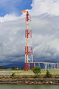 | ||
| man_made | footwear_decontamination | A facility to decontaminate footwear for hikers. |  | ||
| man_made | frost_fan | A device to stop frosts from damaging crops. |  | ||
| man_made | fuel_pump | A fuel pump (petrol pump, gas pump) |  | ||
| man_made | gantry | An overhead structure across a major road usually for holding signs, often variable-message signs. |  | ||
| man_made | gas_well | A natural gas well |  | ||
| man_made | gasometer | Skladište plina Gasometer in Wikipedia |  | ||
| man_made | geoglyph | A large design or motif (generally longer than 4 metres) produced on the ground |  | ||
| man_made | goods_conveyor | A conveyor system for transporting materials | 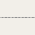 |
 | |
| man_made | groyne | A rigid structure built from a shoreline or riverbank that interrupts water flow and limits the movement of sediment. See also: man_made=breakwater.
|
 |
 | |
| man_made | guard_stone | A guard stone: a stone built onto or into the corner of a building or wall to prevent carriages from damaging the structure, often found on either side of an entrance to a laneway, or alongside a wall to protect it. | 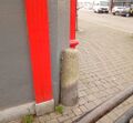 | ||
| man_made | guy_wire | Guy wire designed to add stability to a freestanding structure. |  |
 | |
| man_made | heap | A large pile of material |  | ||
| man_made | hongsalmun | A gate for entering a sacred place in Korea. The gate indicates entry to a sacred realm. |  | ||
| man_made | iljumun | The first gate at the entrance to many Korean Buddhist temples |  | ||
| man_made | insect_hotel | A structure intended to provide shelter for insects. |  | ||
| man_made | kiln | A kiln: an oven used for industrial processes such as hardening, drying, or smelting |  | ||
| man_made | lighthouse | Svjetionik, šalje svjetlosni signal za orijentaciju brodova. |  | ||
| man_made | manhole | Hole with a cover that allows access to an underground service location, just large enough for a human to climb through. | 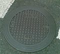 | ||
| man_made | mast | A mast is a vertical structure built to hold, for example, antennas. |  | ||
| man_made | maypole | A tall wooden pole erected as a part of various European folk traditions to celebrate the beginning of summer. |  | ||
| man_made | milk_churn_stand | A current or former collection point for milk churns. |  | ||
| man_made | mineshaft | A mineshaft: vertical tunnel into a mine where minerals are extracted. |  | ||
| man_made | monitoring_station | A station that monitors something. |  | ||
| man_made | nesting_site | A man made nesting aid that is mounted on a support device. |  | ||
| man_made | obelisk | Tall, narrow, four-sided, tapered monument which usually ends in a pyramid-like shape at the top. |  | ||
| man_made | observatory | Observatory: a location used for observing terrestrial or celestial events |  | ||
| man_made | offshore_platform | Offshore platform, oil platform or offshore drilling rig |  | ||
| man_made | oil_gas_separator | Industrial equipment used to separate liquid and gaseous components (oil and gas) produced from a petroleum well. |  | ||
| man_made | oxidation_ditch | An oxidation ditch of a wastewater treatment plant. |  | ||
| man_made | paifang | A traditional style of Chinese architectural arch or gateway structure. |  | ||
| man_made | petroleum_well | Oil well: a hole bored in the earth, designed to bring petroleum oil or gas to the surface |  | ||
| man_made | pier | Mol - "most u more", obično za rekreaciju. |  |
 | |
| man_made | pipeline | Plinovod, naftovod, cjevovod za razne tečnosti. |  | ||
| man_made | planter | A structure for planting flowers or other ornamental plants. |  | ||
| man_made | pump | A device in charge of moving or raising the level of liquids. |  | ||
A pumping rig for producing oil. Use of this tag is discouraged. See man_made=petroleum_well instead.
|
 | ||||
| man_made | pumping_station | Pumping station: a facility including pumps and equipment for pumping fluids from one place to another |  | ||
| man_made | quay | A man-made structure alongside navigable water used for loading and unloading vessels. |  | ||
| man_made | reservoir_covered | Pokriveni rezervoar. |  | ||
| man_made | satellite_dish | A dish-shaped parabolic antenna designed to receive or transmit radio waves to or from a satellite |  | ||
| man_made | sewer_vent | A sewer ventilation shaft |  | ||
| man_made | sign | A permanent physical object displaying messages, like entrance sign of place or city, political sign, but otherwise not covered by advertising=*, tourism=information or historic=epigraph.
|
 | ||
| man_made | silo | A storage container for bulk material, often grains such as corn or wheat |  | ||
| man_made | snow_fence | A solid fence-like structure built across steep slopes to reduce risk and severity of (snow) avalanches. |  | ||
| man_made | spoil_heap | Spoil heap, piles of waste rock removed during mining. |  | ||
| man_made | spring_box | A structure designed for protecting and catching groundwater from a natural spring. |  | ||
| man_made | storage_tank | A container that holds liquids or compressed gases. |  | ||
| man_made | street_cabinet | A cabinet located in the street and hosting technical equipment to operate facilities such as electricity or street lights. |  | ||
| man_made | stupa | A Buddhist dome-shaped structure with a spire on top |  | ||
| man_made | surveillance | Oznaka za mjesta i zgrade s videonazorom |  | ||
| man_made | survey_point | Stupci za triangulaciju, geodetske tačke, fiksna oprema za topografe. |  | ||
| man_made | tailings_pond | Tailings pond: A body of liquid or slurry used to store byproducts of mining operations |  | ||
| man_made | telescope | Telescope: an instrument that aids in the observation of remote objects by collecting light or radio waves |  | ||
| man_made | torii | The gate structure found at the entrance of Shinto shrines and (rarely) Japanese Buddhist temples. |  | ||
| man_made | tower | Toranj, visoka i uska zgrada ili struktura npr. tornjevi za GSM. Vidi i historic=* ispod.
|
 | ||
| man_made | threshing_floor | An open air paved area created to thresh the grain harvest and then winnow it. |  | ||
| man_made | trough | A long, narrow container, open on top, for feeding or watering animals. The water from a trough usually would not be considered drinkable, however, it may be filled from a pipe providing drinkable water. |  | ||
| man_made | utility_pole | A single pole supporting elevation of any of various and unspecified public utilities, such as power transmission, lighting or telephony. |  | ||
| man_made | ventilation_shaft | A vertical space in mines, tunnels, or buildings allowing stale air to leave the space underneath and/or fresh air to enter it. |  | ||
| man_made | video_wall | A digital screen, typically constructed out of smaller LED panels. |  | ||
| man_made | wastewater_plant | Pogon za prečišćavanje otpadnih voda, kanalizacije. |  |
 | |
| man_made | water_tap | Publicly usable water tap, providing access to water and usually equipped with a valve. |  | ||
| man_made | water_tower | Vodotoranj, toranj za skladištenje vode, obično na uzvišenju iznad gradova ili na farmama. |  | ||
| man_made | water_well | A structural facility to access ground water, created by digging or drilling. |  | ||
| man_made | water_works | Vodocrpilište, mjesto gdje se nalazi pitka voda i distribuira se u vodovod. |  |
 | |
| man_made | watermill | Vodenice, većinom stare i van funkcije. |  | ||
| man_made | wildlife_crossing | Structure that allow animals to cross human barriers safely. |  | ||
| man_made | windmill | Vjetrenjače, većinom stre i van funkcije, vidi power=generator u kombinaciji s power_source=wind za moderne zračne turbine.
|
 | ||
| man_made | windpump | A device that pumps natural gas or water using the wind, typically mass produced. |  | ||
| man_made | works | Industrijska zgrada koja nešto proizvodi. |  | ||
| man_made | yes | General tag for man-made (artificial) structures. | |||
| man_made | user defined | vidi Taginfo za druge česte vrijednosti. |
This table is a wiki template with a default description in English. Editable here. Template uređujte ovdje: http://wiki.openstreetmap.org/w/index.php?title=Template:BS:Map_Features:man_made


