RU:Велосипед

|
| Описание |
| Велосипед и велосипедные дорожки. |
| Группа |
| Теги |
|
На этой странице перечислены некоторые возможные варианты того, как вводить и отмечать данные, относящиеся к велосипеду и велодорожкам, в OSM. Наличие качественных данных о велосипедных маршрутах позволяет программному обеспечению маршрутизации выбирать маршрут, наиболее подходящий велосипедистам.
Велосипедные объекты
OSM различает велосипедные полосы и велосипедные дорожки. Велосипедная полосы проходит по самой проезжей части (на дороге), тогда как велосипедная дорожка отделена от дороги (бездорожью). Дорожки обычно отделены от дороги (например, бордюрами, парковками, травяными обочинами, деревьями и так далее).
Есть два способа моделирования велосипедных дорожек. Одна из возможностей — провести отдельные дороги вдоль проезжей части, помеченные highway=cycleway. Альтернативой является добавление тега cycleway=track к существующей линии. У обоих методов есть свои плюсы и минусы. В частности, отдельно помеченная велодорожка обычно позволяет фиксировать больше деталей, в то время как добавление одного тега к существующей дорожке занимает гораздо меньше времени и во многих случаях может быть столь же точным. Оба метода используются сегодня, и ведётся дискуссия о том, когда какой метод лучше выбрать.
Приведённые ниже таблицы со многими примерами и изображениями предназначены для стран с правосторонним движением.
Велосипедные полосы на автомобильных дорогах с двусторонним движением
Полоса, обозначенная на участке проезжей части или обочине, предназначенная для использования велосипедистами.
| Номер | Контекст | Фотография | OSM | Описание |
|---|---|---|---|---|
| L1a | 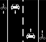 |
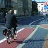
|
Велосипедные полосы слева и справа от дороги.
Линия A: или Линия A: или Линия A: | |
| L1b | 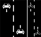 |
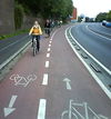
|
Двунаправленная велосипедная полоса справа от дороги.
Линия A: или Линия A: | |
| L2 | 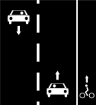 |
Односторонняя велосипедная полоса только с правой стороны дороги.
Линия A: Примечание: велосипеды могут ездить по обычному шоссе с левой стороны |
Велосипедные полосы на односторонних автомобильных дорогах
| Номер | Контекст | Фотография | OSM | Описание | Пример |
|---|---|---|---|---|---|
| M1 | 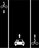 |

|
Велосипедные полосы слева и справа от дороги с односторонним движением.
Линия A: или Линия A: |
370646853 | |
| M2a |  |

|
Односторонняя велосипедная полоса справа и в том же направлении, что и односторонняя автодорога.
Линия A: или |
||
| M2b |  |
Односторонняя велосипедная полоса слева и в том же направлении, что и односторонняя автодорога.
Линия A: или |
cycleway:left=lane 53°16′40.58″ N, 9°04′17.62″ W | ||
| M2c | 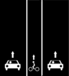 |
Односторонняя велосипедная полоса в направлении односторонней автодороги между полосами движения.
Линия A: |
|||
| M2d | 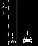 |
Двусторонняя велосипедная полоса на левой стороне дороги с односторонним движением.
Линия A: |
619210833 | ||
| M3a | 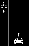 |

|
Односторонняя велосипедная полоса слева и Линия A: |
132400917}} | |
| M3b | 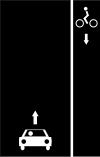 |
Односторонняя велосипедная полоса справа в противоположном направлении от односторонней дороги. Велосипедисты, движущиеся в одном направлении с автомобилями используют полосу движения вместе с другими транспортными средствами, в противоположном — выделенную полосу.
Линия A: |
|||
| M4 | 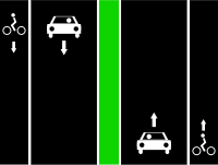 |
 |
Односторонняя велосипедная полоса в правой части разделённых односторонних дорог.
Линия A: такая же, как M2a Линия B: такая же, как M2a |
||
| Альтернативная маркировка для менее точных треков и спутниковых снимков.
Линия A: такая же, как L1a |
|||||
| M5 | 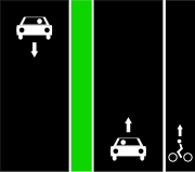 |
 |
Односторонняя велосипедная полоса на правой стороне отдельной односторонней автодороги.
Линия A: такая же, как M2a |
||
| Альтернативная маркировка для менее точных треков и спутниковых снимков.
Линия A: такая же, как L2 |
Велосипедные дорожки
Велосипе́дная доро́жка (велодоро́жка), предназначенная для велосипедистов и отделённаяот проезжей части.
| Номер | Контекст | Фотография | OSM | Описание |
|---|---|---|---|---|
| T1 | 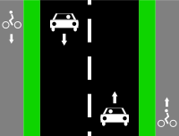 |
|
 |
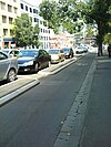
Велосипедные дорожки по левой и правой сторонам дороги.
Линия A: |
| Альтернативное решение с одной линией. Также полезно, когда положение дорожки неизвестно. | ||||
| T2 | 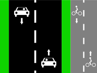 |

|
 |
Двунаправленная велодорожка справа от дороги.
Линия A: |
| Альтернативное решение с одной линией. Также полезно, когда положение дорожки неизвестно.
Линия A: | ||||
| T3 | 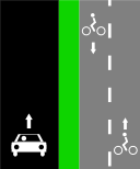 |
 |
Двунаправленная велосипедная дорожка справа от дороги с односторонним движением.
Линия A: | |
| Альтернативное решение с одной линией. Также полезно, когда положение дорожки неизвестно.
Линия A: | ||||
| T4 | 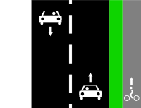 |
 |
Односторонняя велосипедная дорожка справа от автодороги.
Линия A: | |
| Альтернативное решение с одной линией. Также полезно, когда положение дорожки неизвестно.
Линия A: Примечание: велосипеды могут ездить по обычному шоссе с левой стороны. |
Разнообразные ситуации
| Номер | Контекст | Фотография | OSM | Описание |
|---|---|---|---|---|
| S1 |  |
Езда на велосипеде в противоположном направлянии одностороннего автомобильного движения без выделенной дорожки (только в некоторых странах).
Линия A: | ||
| S2 | 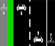 |
 |
Велосипедная дорожка слева и велосипедная дорожка справа от дороги.
Линия A: | |
Линия A: highway=*[1] + cycleway:left=track + cycleway:right=lane
| ||||
| S3 | 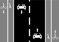 |
Если тротуары отмечены тегом на главной дороге: | ||
 |
Велосипедная дорожка с левой стороны дороги и общая велосипедная дорожка с полосой для автобусов и такси с правой стороны.
Если тротуары рассматриваются как подразумеваемые с главной автомагистралью: Линия A: | |||
| Если тротуары отмечены отдельными линиями:
Линия A: Линия B: Линия C: | ||||
Если тротуары отмечены отдельными линиями без тега highway=path:
Линия A: Линия B: Линия C: | ||||
| S4 | 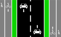 |
Самый простой
Линия A: | ||
 |
Велосипедные дорожки по левой и правой сторонам дороги и тротуарам и пешеходным дорожкам.
Линия A: Линия B: Линия C: | |||
 |
Альтернативное решение с 5 линиями в OSM:
Обратите внимание, этот вариант является спорным, поскольку между велосипедной дорожкой и пешеходной дорожкой нет физического разделителя. По возможности используйте другой вариант. Линия A: Линия B: | |||
| S5 |  |
 |
Самый простой, игнорируются различия в типе поверхности
| |
Используйте cycleway:surface=* и footway:surface=*
| ||||
 |
Добавьте 2 отдельные линии:
Обратите внимание, этот вариант является спорным, поскольку между двумя линиями нет физического разделения. По возможности используйте другой вариант. Линия A: | |||
| S6 |  |
Теги для ступеней с велосипедными пандусами смотрите ramp=*, возможное значение для велосипеда может быть:
| ||
| S7 | Дорога, предназначенная как для велосипедистов, так и для пешеходов, без разделения. Такая комбинированная пешеходная+велодорожка может быть отдельной или тротуаром рядом с дорогой (в этом случае также применим footway=sidewalk).highway=footway/cycleway/path + bicycle=designated + foot=designated + segregated=no + surface=*
| |||
| S8 | Пешеходная дорожка, не обозначенная как велосипедная, но там, где езда на велосипеде разрешена (например, в парке, где это разрешено правилами): |
Велосипедные полосы и полосы для автобусов и такси
| Номер | Контекст | Фотография | OSM | Описание |
|---|---|---|---|---|
| B1 | 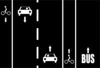 |
Велосипедные полосы по левой и правой сторонам дороги с полосой только для автобусов и такси.
Предложение (нет консенсуса): Использование суффикса для Полос: Примечание: суффикс | ||
| B2 | 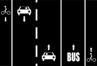 |
Велосипедные полосы на левой и правой сторонах дороги после полосы для автобусов и такси только с правой стороны.
Предложение (нет консенсуса): Линия A: | ||
| B3 | 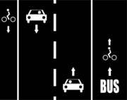 |
Велосипедная дорожка с левой стороны дороги и общая велосипедная дорожка с полосой для автобусов и такси с правой стороны.
Предложение (нет консенсуса): Линия A: | ||
| B4 | 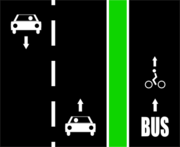 |
 |
Велосипедная дорожка совместно с дорожкой для автобусов и такси на правой стороне дороги.
Предложение (нет консенсуса): Линия A: Линия B: | |
| B5 | 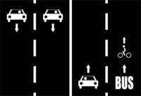 |
Велосипедная полоса совместно с полосой для автобусов и такси на правой стороне дороги (только в некоторых странах).
Предложение (нет консенсуса): Линия A: | ||
| B6 | 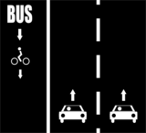 |

|
Велосипедная дорожка совместно с полосой для автобусов и такси в направлении, противоположном односторонней дороге.
Предложение (нет консенсуса): Линия A: или Линия A: |
- ↑ 1.00 1.01 1.02 1.03 1.04 1.05 1.06 1.07 1.08 1.09 1.10 1.11 1.12 1.13 1.14 1.15 1.16 1.17 1.18 1.19 1.20 1.21 1.22 1.23 1.24 1.25 1.26 1.27 1.28 1.29 1.30 1.31 1.32 1.33 1.34 1.35 1.36 1.37 1.38 1.39 1.40 1.41 автомобильные дороги любого типа
highway=*, такие какprimary/secondary/tertiary/unclassified/residential/другие.
Велосипедные улицы и велосипедные дорожки
Велосипедная улица — это улица, предназначенная для велосипедистов с небольшим движением транспорта. В настоящее время это существует в Бельгии, Дании, Германии, Финляндии, Нидерландах, Норвегии, Словении и Швейцарии. Во всех случаях есть определённые дорожные знаки, каждый из которых имеет свое значение. Загляните на вики-страницу cyclestreet для получения более подробной информации.
Эта концепция тесно связана с bicycle_road, которые существуют только в Германии.
Добавьте cyclestreet=yes, не меняя тег highway=*.
Пешеходные улицы
highway=pedestrian + (при необходимости) bicycle=yes
Просёлочные дороги
За пределами городов и густонаселённых районов большинство велосипедных маршрутов наносятся на карту с использованием highway=track, когда дорога также используется крупными моторизованными транспортными средствами (сельскохозяйственными, лесными, машинами скорой помощи…) или highway=path, если она не предназначена для моторизованных транспортных средств (больше для пешеходов, всадников на лошадях…). Хотя оба подразумевают bicycle=yes в большинстве регионов мира велосипедным маршрутизаторам сложно предлагать их в качестве маршрутов, потому что широкий диапазон условий (поверхность пути, уклон, …) может сделать их непригодными для некоторых или всех типов велосипедов.
Некоторые дополнительные теги, которые следует использовать для обозначения пригодности таких способов для велосипедов:
surface=*— поверхность дорогиsmoothness=*— состояние и проходимость дорогиtracktype=*— классификация грунтовокmtb:scale=*— схема классификации сложности трасс для катания на горных велосипедахincline=*— крутизна наклона
Смотрите также Mountain biking.
Езда на велосипеде по дороге (улицы, подходящие для велосипедистов)
Используйте следующие пары «ключ=значение» для обозначения улиц, подходящих для велосипедистов. Эти теги объективны и полезны для определения путей, удобных для велосипедистов.
| Ключ | Значение | Назначение |
|---|---|---|
maxspeed
|
ограничение скорости | Дороги с более низким ограничением скорости, как правило, менее загружены автомобилями. |
source:maxspeed
|
RU:rural/RU:urban/sign/…
|
Всегда указывайте источник ограничения максимальной скорости! |
surface=*
|
для велосипедистов очень существенная разница между surface=asphalt и sand/grass_paver/unhewn_cobblestone (больше, чем для пешеходов или автомобилей). Добавление тегов для гладкости и качества типа трека — два других способа указать качество поверхности дороги или тропы.
| |
traffic_calming
|
Искусственная неровность или препятствия для ограничения скорости движения транспорта — хороший способ ограничить скорость автомобилей и сделать улицу более безопасной для велосипедистов. | |
lanes
|
общее количество обозначенных полос на проезжей части (у этой линии) | Однополосные широкие дороги с низкими ограничениями скорости, как правило, не вызывают стресса (но могут увеличить стресс для велосипедистов, которые хотят ездить на велосипеде быстро). |
width
|
ширина дороги в метрах | Укажите ширину дороги или «бутылочное горлышко» |
shoulder
|
no/yes/left/right/both
|
Наличие обочины. |
cycleway
|
asl
|
Усовершенствованная стоп-линия, также известная как велосипедные боксы (в Северной Америке). |
Ограничения для велосипедов
| Ключ | Значение | Когда использовать |
|---|---|---|
bicycle
|
yes
|
Там, где движение на велосипедах разрешено, несмотря на ограничения по умолчанию для данного вида highway или данной территории (как в случае с автомагистралями, по которым разрешено движение на велосипедах, в западных районах Северной Америки). Тег имеет приоритет над доступом по умолчанию.
|
bicycle
|
designated
|
Там, где путь был специально предназначена (обычно органами власти) для движения велосипедов.
|
bicycle
|
use_sidepath
|
Если езда на велосипеде по главной дороге запрещена законом из-за параллельной обязательной велодорожки. Ознакомьтесь с местными законами. |
bicycle
|
optional_sidepath
|
Езда на велосипеде по главной дороге разрешена законом, но существует параллельная (необязательная) велосипедная дорожка. |
bicycle
|
no
|
Там, где движение на велосипедах не допускается (убедитесь, что это явно обозначено). Обратите внимание, ношение или толкание велосипедов может быть разрешено[1][2]. |
bicycle
|
permissive
|
Если велосипеды не имеют права проезда, но владелец разрешил проезд что них. |
bicycle
|
destination
|
Если велосипеды имеют законное право проезда, но только когда их пункт назначения находится в пределах этой улицы или района. |
bicycle
|
dismount
|
Если езда на велосипеде не разрешена на коротких участках обозначенных велосипедных маршрутов (необходимо спешиться). |
oneway:bicycle
|
yes/no
|
Используйте oneway:bicycle=yes/no для обозначения дорог, на которых правила одностороннего движения для велосипедистов отличаются от общих ограничений одностороннего движения. Если отметить объект, где велосипеды являются единственными разрешенными транспортными средствами, простой oneway=* также часто используется.
|
Смотрите также OSM tags for routing/Access restrictions, чтобы узнать об ограничениях по умолчанию по типу шоссе (и правилах для конкретной страны).
Все значения: access=*.
Информацию об ограничениях для скоростных велосипедов и электрических велосипедов смотрите на соответствующих страницах вики.
Маршруты
Отдельные участки дороги/улицы/тропинки в совокупности могут составлять общий маршрут с официальными указателями.
Они должны быть представлены путем создания отношения с тегами:
…плюс тип сети:
network=lcn— маршруты местной велосипедной сетиnetwork=rcn— маршруты региональной велосипедной сетиnetwork=ncn— маршруты национальной велосипедной сети
В OSM следует вводить только официальные маршруты (то есть те, которые подписаны на дороге и/или опубликованы на картах местными властями). Неофициальные рекомендации (такие как предлагаемые маршруты, опубликованные на общих веб‑сайтах) не формируют официальную инфраструктуру и, как таковые, не являются объективными.
Использование lcn=*/rcn=*/ncn=* для каждого маршрута устарело и больше не должно использоваться.
Отделение от других участников дорожного движения
Отделение от пешеходов на дорожках общего пользования
Там, где путь используется совместно, т.е. как велосипедистами, так и пешеходами, если путь разделен, например, белой линией, следует использовать тег segregated=*:
segregated=yes
|
Велосипедисты и пешеходы разделены, например, белой линией. |
segregated=no
|
Нет разделения между велосипедистами и пешеходами. |
Обратите внимание, что тег segregated=* не имеет ничего общего с разделением на автомобили. Для этого используйте тег separation=*.
Отделение от автомобилей
Если велосипедная дорожка / полоса движения находится внутри дороги и отделена от других транспортных средств, например, защищенных (сегрегированных) велосипедных дорожек, это следует указать с помощью нового тега separation=*.
Это позволяет указать:
- тип разделения;
- на какой стороне велосипедной дорожки находится разделение.
separation=*
|
Используется, когда велосипедная дорожка нарисована на карте отдельной линией (но всё ещё построена на проезжей части). |
cycleway:separation=*
|
Используется, когда велосипедная дорожка картографирована как характеристика линии дороги. |
Преграды и препятствия
Велосипедная инфраструктура может включать в себя различные препятствия, такие как столбики, шлагбаумы, ворота и неровные бордюры.
Поскольку они могут вызывать задержки или даже полностью препятствовать передвижению дял более крупных велосипедов, важно, чтобы такие препятствия были нарисованы на карте.
| Тег | описание |
|---|---|
barrier=cycle_barrier
|
Для обозначения шикан. Можно указать максимальную доступную физическую ширину или индивидуальную ширину интервала/проёма/перекрытия. |
barrier=bollard
|
Столбик на дороге. |
barrier=gate
|
Ворота. |
kerb=no
|
Для случаев, когда между участками дорожки нет бордюра, в результате чего велосипедисту приходится останавливаться/спешиваться. По конструкции, kerb=flush может использоваться для явного объявления типа бордюр (то есть преграды нет).
|
highway=steps
|
Очевидно, что для проезда по лестнице велосипедистам необходимо спешиться. Если есть желоб для колеса (пандус), добавьте ramp:bicycle=yes. Смотрите пример выше.
|
Велопарковка
Велопарковка важна для безопасности велосипедистов. Инфраструктура может варьироваться от отдельных стоянок, запирающихся секций или даже большого здания велопарковки.
| Ключ | Значение |
|---|---|
amenity
|
bicycle_parking
|
В идеале вы также должны указать тип, вместимость (количество циклов) и наличие покрытия. Полная информация приведена на странице bicycle_parking.
Приспособления
Если есть возможность запереть велосипед или взять напрокат (арендовать) велосипеды, используйте:
| Ключ | Значение |
|---|---|
amenity
|
bicycle_rental
|
service:bicycle:rental
|
yes
|
Для магазинов, продающих велосипеды и оборудование:
| Ключ | Значение |
|---|---|
shop
|
bicycle
|
service:bicycle:retail
|
yes
|
Для воздушных насосов, которые можно использовать для заправки велосипедных шин:
| Ключ | Значение |
|---|---|
amenity
|
compressed_air
|
compressed_air
|
yes
|
service:bicycle:pump
|
yes
|
Для станции самостоятельного ремонта:
| Ключ | Значение |
|---|---|
amenity
|
bicycle_repair_station
|
service:bicycle:diy
|
yes
|
Для торгового автомата по продаже велосипедных камер для колёс:
| Ключ | Значение |
|---|---|
vending
|
bicycle_tube
|
Для уличной мебели или приспособлений для велосипедистов, предназначенных для повышения комфорта ожидания, особенно на светофорах (известных как "подставки для ног велосипедиста", "поручни" или "велосипедные упоры"):
| Ключ | Значение |
|---|---|
highway
|
cyclist_waiting_aid
|
Счётчики велосипедов
monitoring:bicycle=*— количество велосипедистов, счётчик велосипедистов (с дополнительным дисплеем, например, тотемом/барометром с часами)
Велосипедные клубы и ассоциации
Онлайн-сервисы, использующие OSM
Картография, тайлы
- OpenCycleMap — проект рендеринга для велосипедистов
- CyclOSM — бесплатный проект рендеринга для каждого велосипедиста
Интерактивные карты
- Bicycle tags map — подвижная карта с OSM-тегами, связанными с велосипедом
- Waymarked Trails — карта, на которой показаны велосипедные маршруты и маршруты для горных велосипедов
- flosm cycle map — велосипедная карта с маршрутами
- CicloMapa — велосипедные карты, точки интереса и показатели для городов Бразилии
- Amenagements-cyclables от GeoVelo — предоставляет местную статистику по Франции и глобальную базовую карту, четко выделяющую широкое определение велосипедных дорожек
Велосипедная маршрутизация
- BRouter — маршрутизация для велосипедистов с разными профилями, на мобильном телефоне или в Интернете (по всему миру)
- Geovelo — маршрутизация для велосипедистов с различными профилями, на мобильных устройствах или онлайн (Европа и Северная Америка)
- CycleStreets — для велосипедистов (Великобритания, большая часть Европы, различные города по всему миру)
- BBBike @ World — планировщик велосипедных маршрутов для более чем 200 городов по всему миру
- cycle.travel — маршрутизация для велосипедистов (Великобритания, Европа, Северная Америка, Австралия + Новая Зеландия)
- GraphHopper — маршрутизация для велосипедистов (по всему миру)
- Komoot — маршрутизация для велосипедных и пеших прогулок (по всему миру)
- Naviki — маршрутизация для велосипедистов (по всему миру)
- Trip4YouMaps [1] — маршрутизация, навигация и отслеживание для велосипедных и пеших прогулок (по всему миру)
Смотрите также
sport=cycling— велоспорт (использование велосипедов для занятий спортом, катанием на горных велосипедах)cycleway:lane=*— тип велодорожки (для обозначения различий между вспомогательными и исключительными велосипедными дорожками)- Proposal:Key:is sidepath — указание, проходит ли велосипедная дорожка параллельно улице, примыкая к ней, или проходит отдельно и, таким образом, отделяется от дороги.
- DE:Bicycle(нем.) — большой "портал", связанный с велосипедным картографированием (на немецком языке)
- Горные велосипеды — маршруты для езды на горных велосипедах
- Туризм — места и вещи, представляющие особый интерес для туристов, включая места, которые стоит увидеть, места для проживания, вещи и места, предоставляющие информацию и поддержку туристам (езда на велосипеде — вид туризма)


