North Korea Mapping Guide

The North Korea Mapping Guide provides an inventory of tags used to map objects in North Korea. It is intended for all contributors who wish to map, and who do not know how to analyze satellite imagery specifically in this country. Both novices and experienced contributors may have difficulty describing objects. This guide prescribes the tags to use. It is a tool for finding the right tag to use.
This inventory is structured in several sections.
- The first section, "Foreword and Tips", lists a set of practices and tips for coordinating contributors.
- The "Transport" section lists the routes according to their classification. It indicates the tags to use for railway infrastructure.
- The next section, "Zone", lists tags to describe land use, and energy generation and transmission infrastructure.
- The "Building" section lists tags for buildings, buildings with a political or social function, and monuments. The '3D Building' section lists the current tags for 3D description in the country.
- The "Topographical names" section lists sources for naming towns and mountains.
- The penultimate section, "Notes and References", contains explanatory notes and links to the documents that were used to write this guide.
- The last section, "Appendixes", gathers articles on the analysis of satellite imagery of the country, and points to the OSM community spaces.
Foreword and tips
Let's face it, Outdoor mapping in North Korea is difficult because accessing the terrain is difficult[1], micromapping is even more so. There are no local contributors, as there is no internet access. Let's use armchair mapping. We are dependent on satellite imagery and their qualities for mapping the country.
- Align the imagery with the elements already drawn, but don't let stories about mismatching stop you.
Very often there is a mismatch between the imagery and the existing paths and points. This is the consequence of a lack of an accessible geodetic benchmark that would allow an alignment.
- Do not offset points already created on an image as each other image would cascade an offset.
- Choose Bing imagery or Esri imagery, depending on which is more accurate or up-to-date.
- Maxar imagery was previously the reference imagery, but the OSM project no longer has access to it since summer 2023.
- Use well-charted regions. e.g. Pyongyang, Nampo and surrounding areas, or Hanggu County.
Transport
Road (highway)
Roads in North Korea are more difficult to map than in other countries, as we don't have a precise map of their layout and classification.
If you're not sure which tag to use to describe the road, don't worry - the route is the most important thing! If someone thinks you've used the wrong tag on a route, they'll change it. It's much quicker for them to change the tag than to re-trace the whole route.
This road classification is taken from the page for African countries. It is based on the Highway_Tag_Africa wiki page and on my experience in trying to classify the roads in this country.
| JOSM | iD editor | Description | Rendering | Photo | |
|---|---|---|---|---|---|
| Roads | |||||
highway=motorway
|
Motorway | A restricted access major divided highway, normally with 2 or more running lanes plus emergency hard shoulder. Equivalent to the Freeway, Autobahn, etc. | 
|
 | |
highway=trunk
|
Trunk Road | The most important roads in a country's system that aren't motorways. (Need not necessarily be a divided highway.)
Note that such roads can be unpaved ([1][2][3] or were unpaved until recently [4]) Note that communities in some countries such as Morocco decided to define it by relying on physical characteristics and trunk roads there are not forming complete network. |

|
 | |
highway=primary
|
Primary Road | Major transportation routes between and into major cities within a country.
Passable by vehicles with 4 or more wheels, engineered alignment. Motorcycles, bicycles, or foot traffic may be restricted. Indicative info only - can vary. Width: 5 to 20 meter; often paved. |

|
 | |
highway=secondary
|
Secondary Road | Major transportation routes connecting cities and large towns. Passable by vehicles with 4 or more wheels, motorcycles, bicycles, or foot and animal traffic. Indicative info only - can vary. Width: 3 to 7 meters; may be paved. |

|

| |
highway=tertiary
|
Tertiary Road | Major transportation routes connecting towns and larger villages. Passable by vehicles with 4 or more wheels, motorcycles, bicycles, or foot and animal traffic. Indicative info only - can vary. Width: 3 to 7 meters; may be paved. |

|

| |
highway=unclassified
|
Minor/Unclassified Road | Minor collector roads that allow travel and commerce from paths and residential roads to and between settlements. While generally not residential, there can be houses along the road.
May be passable by vehicles with 4 or more wheels, motorcycles, bicycles, or foot traffic. Indicative info only - can vary. Width: 3 to 7 meters; may be paved. |

|
.jpg)
| |
highway=residential
|
Residential Road | In urban areas or rural villages, roads which serve as an access to housing, without function of connecting settlements. Often lined with housing.
May be passable by vehicles with 4 or more wheels, motorcycles, bicycles, or foot traffic. Note: this has been edited from the original which said "This tag is used only in urban areas and only on roads which serve no other purpose than residential. " as the East African tagging guide continues to say. Indicative info only - can vary. Width: 3 to 7 meters; may be paved. |

|

| |
highway=service
|
Service Road | Mainly Private Driveways or access roads to homes or businesses for a few hundred meters maximum, does not have a through connecting function.
Passable by vehicles with 4 or more wheels, motorcycles, bicycles, or foot traffic. Indicative info only - can vary. Width: 3 to 7 meters; may be paved. |

|
||
highway=track
|
Unmaintained Track Road | Access route from dwellings to agricultural and forestry areas. Roads within National Parks and Game Reserves may be tagged as tracks. No connection function between settlements.
May be passable by vehicles with 4 wheels, motorcycles, bicycles, or foot traffic. Indicative info only - can vary. Width: 3 to 7 meters; may be paved. |

|

| |
| Paths | |||||
highway=path
|
Path | Travel route between dwellings, settlements, or water sources, and for livestock movement. May be the primary access route for isolated settlements. Connection way by foot within an urban area.
Not passable for vehicles with 4 wheels. Steep grades, narrow width, irregular alignment, obstacles, boulders, stream crossings, and seasonal use. Note: A metal roof arrives by vehicle therefore roads to settlements with metal roofs are typically unclassified or residential (not path) Indicative info only - can vary. Width: 1 to 3 meters; not paved. |

|
.jpg)
| |
Most of the country's population travels on foot or by bicycle. Only 800km out of 787000km are paved[2], so it's more useful to indicate when the road is paved (surface=paved) than when it's unpaved (surface=unpaved).
Train (railway)
North Korea's railway infrastructure is similar to those of other countries in the world:

 Railways, to be described with the tag
 railway=rail
 Platform, to be described with tag
 railway=platform
 Station, to be described with tag
 railway=station
 Station building, to be described with tag
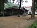
 building=train_station
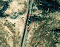
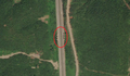
- Three examples of the shape of railways, platforms and stations
-
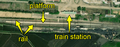 1/3 Railway (
railway=rail), quay (railway=platform), station building (building=train_station) (Maxar satellite imagery). -
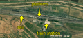 2/3 Railway (
railway=rail), quay (railway=platform), station building (building=train_station) (Maxar satellite imagery). -
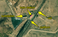 3/3 Railway (
railway=rail), quay (railway=platform), station building (building=train_station), and electrical substation (power=substation) nearby (Maxar satellite imagery).


Zone
Landcover (natural)
Landcover represents the vegetation or soil composition visible on satellite images, with no connection to their use. In English, "land" means land or terrain, "cover" means cover.
The most common landcover tags in this area are:
Landcover classification
| Tag (key, value) | Name | Description | Satellite imagery |
|---|---|---|---|
natural=wood
|
Wood | Area covered with trees (a "forest" or "wood").
This area is not maintained by human intervention, unlike |
 |
natural=water
|
Water | Any body of water, whether natural, such as a lake or pond, or artificial, such as a moat or canal.
You can specify the type of water body with |
 |
natural=scrub
|
Scrub | Uncultivated land covered with shrubs, bushes or stunted trees. |
 |
natural=grassland
|
Prairie | Areas where vegetation is dominated by grasses and other herbaceous (non-woody) plants, excluding cultivated areas and wetlands. |  |
natural=wetland
|
Wetlands | Natural area subject to flooding or waterlogged soil.
It can be specified with |
 |
natural=bare_rock
|
Rock | An area with little or no vegetation, so that the bedrock becomes visible. |  |
Landuse (landuse)
The landuse represents the specific use of land for human activities. In English, "land" means "land" or "terrain", "use" means "use", "employment".
The most common landuse tags in this area are as follows:
Landuse classification
| Tag (key, value) | Type | Description | Satellite imagery |
|---|---|---|---|
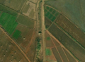
landuse=farmland
|
Farmland | An area of farmland used for tillage (mainly rice, corn, wheat and potatoes[3]). |  |
landuse=residential
|
Residential area | An area of land devoted to residential buildings, or containing mainly residential buildings such as houses or apartment buildings.
This tag is mainly used for large areas and not for parcel granularity. |
 |
landuse=forest
|
Forest | A wooded area, maintained or used by humans. |  |
landuse=grass
|
Grass | An area of low, regularly mown grass, e.g. around a monument, in a park, on the edge of a road, in the middle of a dual carriageway. |  |
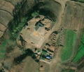
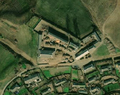
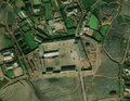
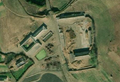
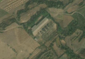
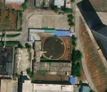
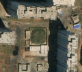
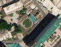
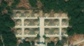
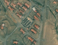
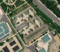
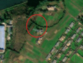
School (school)
 Schools, the school compound is to be described with the tag
 amenity=school, and each building withbuilding=school
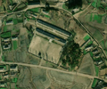
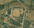
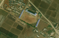
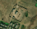
- Four examples of school shapes in cities
-
 1/4 Classic school form (
amenity=school) consisting of two long buildings close together (building=school) and a large schoolyard in front (Maxar satellite imagery). -
 2/4 Classic shape of a school in North Korea (
amenity=school,building=school) (Maxar satellite imagery). -
 3/4 Rarer form of school (
amenity=school) consisting of two long buildings close together at right angles (building=school) with a large courtyard in front (Maxar satellite imagery). -
 4/4 Even rarer form of school (
amenity=school) consisting of three long buildings (building=school) and a large schoolyard in front (Maxar satellite imagery).


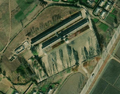
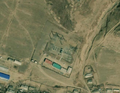
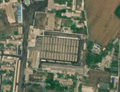
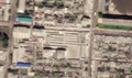
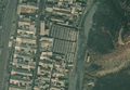
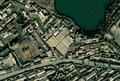
Farmyard (farmyard)
- Six examples of farmyard shapes
-
-
-
-
-
-
 6/6 Farmyard (
landuse=farmyard) composed of long buildings dotted with hay stacks. Disordered cemetery in lower right of image (see section on cemeteries for more detail) (Maxar satellite imagery).


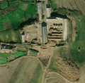
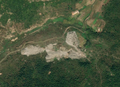
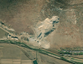
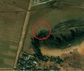
Mine (quarry)
- Four examples of mining area shapes
-
 1/4 A mining area (
landuse=quarry) characterised by a break with the nearby vegetation. It is recognisable by its grey colour (Maxar satellite imagery). -
 2/4 Mining area (
landuse=quarry) characterised by a weaker break with the vegetation and a hollowed out relief that can be spotted by shadows. It is recognisable by its grey colour (Maxar satellite imagery). -
 3/4 Mining area (
landuse=quarry) on an island more difficult to recognize, but which breaks with the vegetation on the upper part of the image (Maxar satellite imagery). -
 4/4 Mining area (
landuse=quarry) spread out in length, characterised by a break with the vegetation nearby. It is recognisable by its grey colour and uniform texture (Maxar satellite imagery).


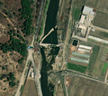
Energy
Electricity (power)
Electricity networks are composed of these elements:
 Major power line, to be described with tag
 power=line(supported by pylonspower=tower) Minor power line, to be described with tag
 power=minor_line(supported by simple polespower=pole) Power pole, to be described with tag
 power=pole(it supports a minor power linepower=minor_line) Power tower, to be described with the tag
 power=tower(it supports a major power linepower=line) Electricity substation, to be described with the tag
 power=substation
Poles, pylons and power lines are complicated to locate. You have to help yourself to the long, thin shadows they leave on the ground to identify them. The spacing between each tower or pole in a network is regular, so it is possible to estimate where a pole or tower should be located and to search in that area. Electrical substations are often surrounded by poles or towers, and are composed of small dark elements close together with short shadows.
Pylon and tower (pole, tower)
- Major power line, to be described with tag
power=line(supported by towerspower=tower) - Minor power line, to be described with tag
power=minor_line(supported by single polespower=pole)
- Five examples of shapes to recognise power pylons and poles
-
 1/5 Power pole (
power=pole) visible due to its thin and long shadow cast (Maxar satellite imagery). -
 2/5 Power tower (
power=tower) on the left and power pole on the right visible thanks to their thin and long shadow (Maxar satellite imagery). -
 3/5 Electricity pylons (
power=tower) visible thanks to their thin and long shadows and the regular spacing between them (Maxar satellite imagery). -
 4/5 Power tower (
power=tower) in an open agricultural area (Maxar satellite imagery). -
 5/5 Power pylon (
power=tower) and power poles visible due to their thin and long shadows (Maxar satellite imagery).


Electrical substation (substation)
- Electric substation, to be described with tag
power=substation
- Four examples of the shape, location and composition of electrical substations
-
 1/4 Electrical substation (
power=substation) in the middle of a city that stands out with many shadows cast over a small area (Maxar satellite imagery). -
 2/4 Substation (
power=substation) in the middle of a city which can be recognized with many small features on a flat surface (Maxar satellite imagery). -
 3/4 Substation (
power=substation) with many poles around and small shadows in its enclosure (Maxar satellite imagery). -
 4/4 Substation (
power=substation) with many poles around and small shadows in its enclosure (Maxar satellite imagery).


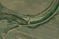
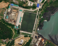
Water (water, waterway)
There are different types of dams on rivers:
 Dam, to be described with tag
 waterway=dam; this is the most common structure to dam a stream, and form a retention lake Weir or small dam, to be described with the tag
 waterway=weir; it is an obstacle smaller thanwaterway=damthat allows water to spill over it
There are different types of waterways:
 Ditch, to be described with tag
 waterway=ditch.- Channel, to be described with tag
waterway=canal. - River, to be described with tag
waterway=stream.  River, to be described with tag
 waterway=river.
Locating the route of rivers is the most important, as for routes. The classification of waterways is to be assessed on a case by case basis. The finest waterways are tagged with waterway=ditch.
If you have identified a waterway, follow its course until it crosses a road. If it is a waterway, it should have a bridge or ford. If not, it is a road. Look to see if it is connected to a larger water system.
The retention lake created by a dam is to be described with the two tags natural=water and water=reservoir.
- Pumping station, to be described with the tag
man_made=pumping_station; it is a building used for drainage or irrigation. It is in the immediate vicinity of a watercourse and is often close to an agricultural area, connected by ditches/channels.
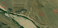
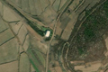
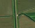
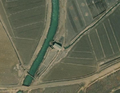
Barrage (dam, weir)
- Dam, to be described with tag
waterway=dam; this is the most common structure to dam a stream, and form a retention lake - Threshold or small dam, to be described with tag
waterway=weir; it is a barrier smaller thanwaterway=damthat allows water to spill over it
- Six examples of dam and small dam structure and shape
-
 1/6 Dam (
waterway=dam) that comes to cut off from a stream by its thick structure (Maxar satellite imagery). -
 2/6 Dam (
waterway=dam) in the middle of a watercourse (Maxar satellite imagery). -
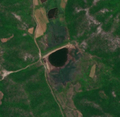 3/6 Dam (
waterway=dam) holding back water from a reservoir (Maxar satellite imagery). -
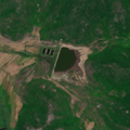 4/6 Dam (
waterway=dam) holding back water from a reservoir (Maxar satellite imagery). -
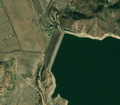 5/6 Dam (
waterway=dam) holding back water from a large impoundment (Maxar satellite imagery). -
 6/6 Small dam (
waterway=weir) that cuts off a stream leaving a smaller flow and bed to the south (Maxar satellite imagery).


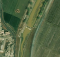
Pumping station (pumping_station)
- Pumping station, to be described with the tag
man_made=pumping_station; it is a building used for drainage or irrigation. It is in the immediate vicinity of a watercourse and is often close to an agricultural area, connected by ditches (ditch) and channels (canal).
- Four examples of pumping station location and shape
-
 1/4 Pumping station (
man_made=pumping_station) isolated on a stream near a road (Maxar satellite imagery). -
 2/4 Pumping station (
man_made=pumping_station) isolated at the end of a watercourse and close to a road (Maxar satellite imagery). -
 3/4 Pumping station (
man_made=pumping_station) close to a stream and a road (Maxar satellite imagery). -
 4/4 Pumping station (
man_made=pumping_station) connecting a watercourse to the canal system (Maxar satellite imagery).


Covered water tank (reservoir_covered)
There are covered reservoirs for the water supply system. They are large circular tanks 20-30 metres in diameter and are located close to residential buildings in urban areas.
- Covered water tank, to be described with the tag
man_made=reservoir_covered
- Four examples of the structure and shape of a covered reservoir
-
 1/5 Covered reservoir (
man_made=reservoir_covered) round-shaped in the middle of a dense urban area in Pyongyang (Maxar satellite imagery). -
 2/5 Covered reservoir (
man_made=reservoir_covered) round-shaped in the middle of a dense urban area in Pyongyang (Maxar satellite imagery). -
 3/5 Covered reservoir (
man_made=reservoir_covered) round-shaped in the middle of a dense urban area in Pyongyang (Maxar satellite imagery). -
 4/5 Covered reservoir (
man_made=reservoir_covered) round-shaped, along the road, in the middle of a dense urban area in Pyongyang (Maxar satellite imagery). -
 5/5 Covered reservoir (
man_made=reservoir_covered) round-shaped in the middle of a dense urban area in Pyongyang (Maxar satellite imagery).


Water towers (water_tower)
Water towers are round, vertical concrete structures around 10-15 metres high. The shadow cast on the ground makes them easier to recognize.
 Water tower, to be described with tag
 man_made=water_tower
- Two examples of water towers from satellite imagery
-
 1/2 Water tower in Pyongyang, with its round, vertical structure, and its cast shadow clearly visible on the ground (Esri satellite imagery).
 -
 2/2 Water tower in Hyangsan-up, the cest shadow is harder to see but the structure is round and vertical (Bing satellite imagery).


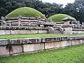
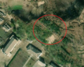
Cemetry (cemetery)
At the end of the Korean traditional funeral rite, a mound of earth and grass is erected over the graves[4], making it possible to recognize its graves from satellite imagery.
There are two types of cemeteries, described with the same landuse=cemetery tag:
 Ordered cemeteries, consisting of clearly demarcated mounds (image 1, 2 and 3).
- Disordered cemeteries, created during the period of the "the arduous march" (famine from the years 1994 to 1998), more irregular and without clear demarcation on large and sometimes hilly areas, which look like bomb hits from satellite imagery (image 3 to 6)[5].
- Eight examples of ordered and disordered cemetery shapes from satellite imagery, with a ground shot
-
 1/8 Orderly cemetery (
landuse=cemetery), characterised by regular mounds with straight paths (Maxar satellite imagery). -

-
 3/8 View of the ground of an ordered cemetery characterised by a mound of earth covered with grass.
 -
-
-
-
-
 8/8 Orderly and disordered cemetery side by side (
landuse=cemetery) (Maxar satellite imagery).


.jpg)


Burial mound used as graves can be mapped when they are imposing and individually distinguishable.
- two examples of burial mound from satellite imagery
-
 1/2 Earth mound representing an important tomb (Bing satellite imagery)
 -
 2/2 Earth mound representing an important tomb (Bing satellite imagery)


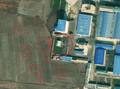
Public market (marketplace)
Public markets in North Korea have a structure recognisable from satellite imagery.
They are bounded by walls, in principle. They are made up of stalls, which are rectangular structures that are very close to each other. These stalls are smaller in width than a house by a greater or lesser length, the stalls are often arranged in an orderly fashion sometimes along an axis that runs through the market[6]. Markets are located in cities, from satellite views the roof is grey or white (the classic colour of the country's buildings) or very rarely red or blue[7].
 Public Marketplace, to be described with tag
 amenity=marketplace
- Seven examples of public market form
-
 1/7 Public market (
amenity=marketplace) with twelve stalls, surrounded by a perimeter wall along an axis running through them (Maxar satellite imagery). -
 2/7 Public market (
amenity=marketplace) with many stalls crossed by a long axis in front of the entrance on the left along the road (Maxar satellite imagery). -
 3/7 Public market (
amenity=marketplace) with twenty-one stalls, surrounded by a perimeter wall (satellite imagery Maxar). -
 4/7 Public market (
amenity=marketplace) with nine stalls, surrounded by a perimeter wall along an axis running through them (Maxar satellite imagery). -
 5/7 Public market (
amenity=marketplace) with many stalls, surrounded by a perimeter wall (Maxar satellite imagery). -
 6/7 Public market (
amenity=marketplace) with many stalls (Maxar satellite imagery). -
 7/7 Public market (
amenity=marketplace) with three spaced stalls, surrounded by a perimeter wall (Maxar satellite imagery).


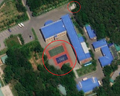
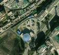
Sports field (pitch, sport)
Sports pitches are concentrated in large urban areas. They can be identified by the markings on the ground. The most common sports pitches are: basketball, football, volleyball, badminton. The colour of the field does not follow any rule, they can be directly traced on the asphalt or be blue, red, green, etc.
- basketball court, to be described with the tag
leisure=pitchandsport=basketball - football field, to be described with the tag
leisure=pitchandsport=soccer - volleyball court, to be described with tag
leisure=pitchandsport=volleyball - badminton court, to be described with tag
leisure=pitchandsport=badminton - tennis court, to be described with tag
leisure=pitchandsport=tennis
- Eight examples of sports ground shape and layout
-
-
-
-
-
 5/8 Diagram of a badminton court, top view
 -
 6/8 Schematic of a tennis court, top view
 -
 7/8 Schematic of a volleyball court, top view
 -
 8/8 Schematic of a basketball court, top view


Sometimes the quality of the image (or the quality of the pitch) makes it difficult to recognize the lines of the pitch. It is possible to deduce which sport is played on the pitch by calculating its size.
Here's an example of a standard court size (length x width):
 basketball: 28m x 15m
 tennis : 23,77m x 10,97m
 volleyball: 18m x 9m
 badminton : 13,40m x 6,10m
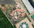
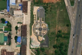
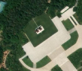
Traffic park (traffic_park)
Traffic parks are areas for children to learn road safety rules.
- Traffic park, to be described with the tag
amenity=traffic_park
These areas are composed of:
- asphalt roads, to be described with the tag
highway=cyclewayandaccess=private - L-shaped buildings with a rounded inner corner


- Four examples of traffic park form
-
 1/4 Traffic park (
amenity=traffic_park) (Maxar satellite imagery) -
 2/4 Traffic park (
amenity=traffic_park) (Maxar satellite imagery) -
 3/4 Traffic park (
amenity=traffic_park) (Maxar satellite imagery) -
 4/4 Traffic park (
amenity=traffic_park) (Maxar satellite imagery)


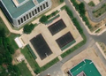
Industry (industrial, man_made)
Industrial areas use many tags with the keys industrial=*, power=* and man_made=*.
 Industrial area, to be described with the tag
 landuse=industrial
The most frequent and recognizable values in this country are:
 Chimney, to be described with tag
 man_made=chimney Tank, please describe with tag
 man_made=storage_tank Pipeline, to be described with tag
 man_made=pipeline- Depot, to be described with tag
landuse=depot
Storage tank (storage_tank)
A storage tank is a container for compressed liquids or gases. It can be identified by its circular shape. Its roof is white or sometimes grey. The tanks are grouped together.
- storage tank, to be described with the tag
man_made=storage_tank
- Four examples of storage tank shapes
-
 1/4 Storage tank (
man_made=storage_tank) near a water area (Maxar satellite imagery). -
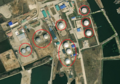 2/4 Storage tank (
man_made=storage_tank) along a water area (Maxar satellite imagery). -
 3/4 Storage tank (
man_made=storage_tank) in a highly urbanised centre with a mural (tourism=artworkandartwork_type=mural) and a monument (historic=memorial) (Maxar satellite imagery). -
 4/4 Storage tank (
man_made=storage_tank) in a highly urbanised centre (Maxar satellite imagery).


Military
| Caution: mapping military installations is welcomed in OpenStreetMap, but may be prohibited by local law. Before mapping potentially sensitive sites such as these, please be aware of Section I b of the OSMF Terms of Use: "You are responsible for your own actions [...] OSMF generally cannot offer any protection, guarantee, immunity or indemnification." |
For a complete list of what can be mapped in a military area see military=*.
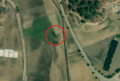
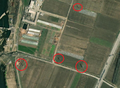
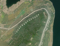
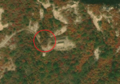
Tank Trap (tank_trap)
Tank traps are stone pillars along roads in the vicinity of the DMZ in the south of the country. These pillars are defence systems that are knocked down on the road to prevent the advance of tanks.
These pillars are placed at strategic locations, such as before or after a bridge, in a valley, along a highway.
- Six examples of tank trap shapes
-
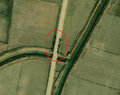 1/6 Stone pillars (
barrier=tank_trap) along the road after a bridge (Maxar satellite imagery). -
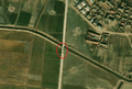 2/6 Stone pillars (
barrier=tank_trap) along the road before a bridge (Maxar satellite imagery). -
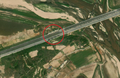 3/6 Stone pillars (
barrier=tank_trap) along the highway from Kaesong to Pyongyang (Maxar satellite imagery). -
 4/6 Stone pillars (
barrier=tank_trap) along the highway (Maxar satellite imagery). -
 5/6 Stone pillars (
barrier=tank_trap) along the road in the valley (Maxar satellite imagery). -


.jpg)
Building
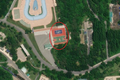
Building in city centre
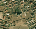
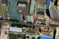
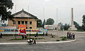
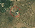
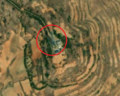
Towns and villages, very often concentrate the following three elements in their town centre: a town hall, a tower of immortality and a building for cultural activities. The "tower of immortality"[8] is a kind of obelisk. This tower is sometimes accompanied by a mural[9], statues are rarer and are mainly found in Pyongyang and in the centre of major cities as well as medium-sized towns.
From satellite imagery, immortality towers, murals and statues leave a shadow on the ground. This shadow varies in size; immortality towers leave a long, straight shadow, statues leave a short, imprecise shadow, murals leave a short, wide shadow.
Small towns and villages use one building for all 'cultural' activities, it acts as an ideological study hall and theatre. Large cities have different buildings for theatres and study rooms.
The buildings in the town centre can be described as follows:
 City People's Committee, a kind of town hall[10], to be described with the tag
 amenity=townhall Juche Study Hall[11] which are places for community, to be described with the tag
 amenity=community_centre The immortality towers, to be described with tag
 historic=memorialandmemorial=immortality_tower
And more rarely :
 Mural frescoes[9], to be described with the two tags
 tourism=artworkandartwork_type=mural Statues, to be described with the two tags
 tourism=artworkandartwork_type=statue
- Seven photos and satellite imagery of city centres and pattern of Juche Study Hall
-
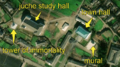
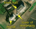
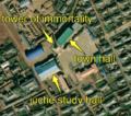 1/7 City centre that concentrates an immortality tower (
historic=memorialandmemorial=immortality_tower), with its shadow cast on the ground, a juche study hall (amenity=community_centre), with its specific shape, and a city hall (amenity=townhall) (Maxar satellite imaging). -
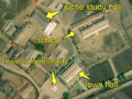 2/7 Another city centre regrouping a school (
amenity=school), characterized by two long buildings (building=school) with a large courtyard in front (cf. Schools, a juche study hall (amenity=community_centre), with its specific shape, the immortality tower (historic=memorialandmemorial=immortality_tower), with its shadow on the ground, and the city hall (amenity=townhall) (Maxar satellite imagery). -
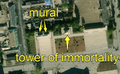
 3/7 Another city centre with a mural (
tourism=artworkandartwork_type=mural), recognisable because it has the shape of a wall that leaves a shadow on the ground, with no building in the immediate vicinity, a juche study hall (amenity=community_centre), with its specific shape, the Tower of Immortality (historic=memorialandmemorial=immortality_tower), with its shadow on the ground, and the Town Hall (amenity=townhall) (Maxar satellite imagery). -
 4/7 City centre of a large city with two murals (
tourism=artworkandartwork_type=mural), recognisable because they have the shape of a wall that leaves a shadow, with nothing around it, and a tower of immortality (historic=memorialandmemorial=immortality_tower), with its shadow cast on the ground, (Maxar satellite imagery). One of the murals was added after 2011, the year Kim Jong-il died. -
 5/7 City centre concentrating a mural (
tourism=artworkandartwork_type=mural), a tower of immortality (historic=memorialandmemorial=immortality_tower), with its shadow cast on the ground, and a city hall (amenity=townhall) (Maxar satellite imagery) -
 6/7 Close-up of a T-shaped Juche Study Hall (
amenity=community_centre). -
 7/7 Diagram of the different recurring shapes of the Juche Study Hall (
amenity=community_centre) as seen from above.


Points of interest
North Korea is dotted with many monuments to the glory of the regime and its leaders, such as the immortality tower, murals, statues etc.

Each of these elements is mapped with a node.
- Tower of Immortality, to be described with tag
historic=memorialandmemorial=immortality_tower - Mural fresco, to be described with the two tags
tourism=artworkandartwork_type=mural - Statue, to be described with the two tags
tourism=artworkandartwork_type=statue - Pagoda, to be described with the two tags
man_made=towerandtower:type=pagoda - Giant slogans with support, are to be described with
man_made=signandmessage=politicaland transcribe the korean text (hangeul) withinscription=* - Giant slogans without support, directly inscribed on the ground, are to be described with
man_made=geoglyphand transcribe the korean text (hangeul) withinscription=*
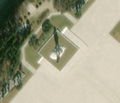
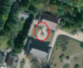
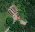
Tower of Immortality (memorial)
- Tower of Immortality, to be described with tag
historic=memorialandmemorial=immortality_tower
- Three examples with comparison of the towers of immortality seen from the ground and seen from satellite imagery
-
 1/3 Shape of a tower of immortality (
historic=memorialandmemorial=immortality_tower). -
 2/3 Tower of immortality (
historic=memorialandmemorial=immortality_tower), which can be distinguished by its shadow on the ground and the absence of a building in its immediate vicinity (Maxar satellite imagery). -
 3/3 Mural fresco (
tourism=artworkandartwork_type=mural) and immortality tower (historic=memorialandmemorial=immortality_tower) with no building in the immediate vicinity on the right side of the image.


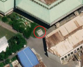
Statue (statue, artwork)
- Statue, to be described with the two tags
tourism=artworkandartwork_type=statue
- Four comparison images of statue seen from the ground and with satellite imagery
-
 1/4 Statue of Kim Il-sung (
tourism=artworkandartwork_type=statue) on its white base with trees in the background seen from the ground. -
 2/4 The same statue of Kim Il-sung (
tourism=artworkandartwork_type=status) on its white base with the trees in the background which leaves a long shadow on the satellite imagery (satelliteimage Maxar). -
 3/4 Statues of Kim Il-sung and Kim Jong-Il (
tourism=artworkandartwork_type=statue) in bronze on their square base seen from the ground. -
 4/4 The same statues of Kim Il-sung and Kim Jong-Il (
tourism=artworkandartwork_type=statue) on a white square plinth with satellite imagery (satellite imagery Maxar).


.jpg)

Giant slogan (sign)
- Giant slogans with support, are to be described with
man_made=signandmessage=politicaland transcribe the korean text (hangeul) withinscription=* - Giant slogans without support, directly inscribed on the ground, are to be described with
man_made=geoglyphand transcribe the korean text (hangeul) withinscription=*
- Three examples of the shape of giant Korean slogans flat on the floor and with a support system
-
 1/3 Giant slogan composed of a sign system each korean (hangeul) character (Maxar satellite imagery).
 -
 2/3 Giant slogan composed of a sign system each korean (hangeul) character (Maxar satellite imagery).
 -
 3/3 Giant slogan flat, korean (hangeul) text without a support system (Maxar satellite imagery).


Pagoda (tower)
 Pagoda, to be described with the two tags
 man_made=towerandtower:type=pagoda
- Two comparison images of pagoda seen from the ground and seen from satellite imagery
-
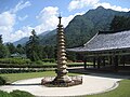 1/2 Form of a stone pagoda (
man_made=towerandtower:type=pagoda) within a monastery. -
 2/2 The same pagoda (
man_made=towerandtower:type=pagoda) which leaves a shadow on the ground allowing it to be distinguished. The pavilions nearby are typical of Buddhist architecture (Maxar satellite imagery).
.jpg)

Stele (memorial)
The memorials are located close to other monuments in the city centres of major cities. The steles are difficult to recognize with satellite imagery of average quality.
- Stele, to be described with the tag
historic=memorialandmemorial=steleand transcribe the korean text (hangeul) withinscription=*
- Five examples of stele shapes
-
-

-

-
-

.jpg)


.jpg)
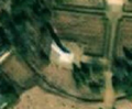
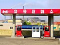
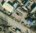
Petrol station (fuel)
Fuel stations are characterised by a flat roof without walls supported by several poles. They are often located next to or in large urban areas, along major roads with quick access to the road.
Petrol stations are recognisable from satellite imagery taken at the end of the day. They show a long shadow that hints at the wall-less structure resting on the poles.
Use the late day shots to confirm that this is a petrol station.
- Three photos and satellite imagery of gas stations
-
-
 2/3 The same gas station (
amenity=fuel), close to a road, in an urban area with quick access to the road. On this satellite imagery, the flat roof structure and the four pillars can be seen thanks to the shadow on the ground (Esri satellite imagery). -
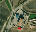 3/3 Gas station (
amenity=fuel) located south of Kowon, along the main road, with a shadow cast revealing the structure with posts (Bing satellite imagery).


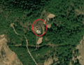
Communication tower (tower, communication)
A communications tower[12], is a small building with an antenna, recognizable by a long shadow cast. It is located on the top of the plains or mounts near cities, or on reliefs.
 Communication tower, to be described with tag
 man_made=towerandtower:type=communication
- Eight examples of communication tower shapes
-
 1/8 Communication tower (
man_made=towerandtower:type=communication), with antenna and small building, on top a mountain near the town of Hamhung (Esri satellite imagery). -
 2/8 The same communication tower (
man_made=towerandtower:type=communication) seen from the ground, with the antenna and a small building surrounded by a fence at the top of the mountain near the town of Hamhung. -
 3/8 Communication tower (
man_made=towerandtower:type=communication), with an antenna and a small building, on top of a mountain (Maxar satellite imagery). -
 4/8 Communication tower (
man_made=towerandtower:type=communication), with an antenna and a small building (Maxar satellite imagery). -
 5/8 Communication tower (
man_made=towerandtower:type=communication), with an antenna casting a shadow and a small building, in a valley (Maxar satellite imagery). -
 6/8 Communication tower (
man_made=towerandtower:type=communication), with an antenna and a small building, on top of a plain (Maxar satellite imagery). -
 7/8 Communication tower (
man_made=towerandtower:type=communication), with an antenna and a small building, on top of a plain (Maxar satellite imagery). -
 8/8 Communication tower (
man_made=towerandtower:type=communication), with an antenna and a small building, on top of a mountain (Maxar satellite imagery).


3D Building
Buildings in North Korea in the countryside have a rectangular shape, while in the city they have a more complex shape to map. One way to see the result is to access the link demoF4map for example.
Height and floor
Below is an excerpt from Simple 3D Buildings, which condenses the most common building and roof types in North Korea.

| Key | Comment |
|---|---|
height=*
|
The distance from the ground to the top of the roof, excluding antennas, wind vanes and other roof-mounted equipment. |
building:levels=*
|
Number of floors of the building above ground level (without the roof level), allows you to texture the building in a simple way.
If you are adding new buildings, try to give a height value with |
Roof
You can describe the roof of a building with different tags, the most common ones in North Korea are the following:
| Image | 
|

|

|

|

|
|---|---|---|---|---|---|
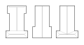
| roof:shape | flat
|
gabled
|
hipped
|
round
|
hipped-and-gabled
|
| Meaning | flat | gabled | hipped | round | hipped-and-gabled |
Topographical names

It is possible to add the names of towns in North Korea thanks to GeoNames which offers a georeferencing service (http://www.geonames.org/v3/) that is supplied by the National Geospatial-Intelligence Agency (NGA) for North Korea, but this data is sometimes out of date with place names pre-dating 1945, discussion on a changeset on the subject.
Other topographic maps are available, but under copyright:
![]() It is forbidden to copy other maps, the links below should only be used to find out if the NGA data is correct or not.
It is forbidden to copy other maps, the links below should only be used to find out if the NGA data is correct or not.
- National Geographic Information Institute, Maps accessible from South Korea, see also: quick data presentation.
- North Korean Human Geography, CyberNK map with 2008 data, see also: site presentation.
- 38North Digital Atlas, map by 38 North research center.
- North Korean map of certain Special Economic Zones "와우도수출가공구(Waudo Export Processing Zone)".
Notes and references
- ↑ It is conceivable to go into the field on a language or tourist trip but the area is rather limited to Pyongyang in principle.
- ↑ https://www.globalsecurity.org/military//world/dprk/roads.htm
- ↑ https://www.globalsecurity.org/military//world/dprk/economy1.htm
- ↑ In English, cemetry or mound or burial mound
- ↑ During the famine of the 1990s, there were too many deaths at the same time, this forced North Koreans to find new places to bury their dead. The hills surrounding cities and villages served this function (in English grave mound); More details on the relationship of Koreans to their dead on this article: A very North Korean way to die - NK News
- ↑ Researcher Jenny Town describes it as "long, narrow, blue-roofed, single-story buildings" (Jenny Town, 2020, The Uses and Challenges of Satellite Imagery in Researching North Korea')
- ↑ Public markets were created after the famine of the 1990s by a formal integration of some illegal markets into the country's legal economic system. Growth and Geography of Markets in North Korea: New Evidence from Satellite Imagery, Benjamin Katzeff Silberstein, October 2015, Read online (abstract)
- ↑ In English, Immortality Tower, or sometimes Tower of Eternal Life or Tower of Immortality'
- ↑ 9.0 9.1 In English, mural or murals
- ↑ In English City People's Commitees or town hall, (시인민위원회)
- ↑ Juche Study Hall (주체연구실) or Palace of culture (문화궁전). Jacob Bogle defines it as "Every town has at least one 'Juche Study Hall', they go by a number of different names including, palace of culture (문화궁전) and Kimilsungism-Kimjongilism study hall (김일성-김정일 주의연구실). These basically play the equivalent role of churches in Europe and the Americas in centuries past. Centrally located, this is where people are required to go multiple times a month (at least) to be indoctrinated in the latest Party orders, to learn about the exploits of the leadership, and to hold "self-criticism" sessions." These are community places, for public gatherings and events etc. This existed in China, the USSR and socialist countries more generally
- ↑ In English, communications tower
Appendixes
Related articles
Discussions
- How to map a political sign ? - OSM Forum
- How to tag differently "ordered" and "disodered" cemetries ? - OSM Forum
- Road numbers in North Korea - OSM Forum
External resources
Sites
- AccessDPRK
- Theme of article from "38 North" with tag "satellite imagery", on imagery analysis
- CITY-NKOR
Academic articles
- The uses and challenges of satellite imagery in North Korea research, Jenny Town, 2020
- A study of OSM contributors to North Korea → Cartographers of North Korea, An analysis of the OpenStreetMap data in North Korea: Who are the contributors? How and why did they contribute to North Korea? ", Wonyoung So, 12 May 2021
Press articles
- NK News article, On imaging in North Korea
Wikipedia articles
- Satellite imagery in North Korea
- Roads in North Korea
- Administrative divisions of North Korea
- Immortality Tower
Others
- Pictures on the country, by Eric Lafforgue
- Pictures of "Immortality Towers", by Raymond Cunningham on Flickr