Vermont
| V・T・E |
| latitude: 43.87, longitude: -72.48 |
| Browse map of Vermont 43°52′12.00″ N, 72°28′48.00″ W |
| Edit map |

|
|
External links:
|
| Use this template for your locality |
Vermont is a state in the United States at latitude 43°52′12.00″ North, longitude 72°28′48.00″ West.
Roads
Highway classification in the general-purpose road network
In OSM, roadways are primarily categorized using a highway=* tag that indicates the roadway's importance in the road network. See US highway classification for more details and background. This section describes Vermont-specific determinations for implementing this categorization.
1: highway=motorway
See United States/Highway classification#Motorway.
As a rural state with few major population centers, the only roads that should be tagged as highway=motorway are the Interstates (I-89, I-189, I-91) and non-Interstate highways built to the same standard (US-4 west of its junction with US-7). Other roadways that meet some, but not all of the criteria (such as US-7 near Bennington, VT-289, VT-127, etc) should not be tagged with highway=motorway, but rather another highway classification that represents their importance in the regional road network, with expressway=yes and access_control=* to indicate their enhanced level of construction.
2: highway=trunk
See United States/Highway classification#Trunk.
"As the top non-motorway classification,
highway=trunkshould be applied in the following cases:
- In areas of high population density, to expressways that meet most, but not all, of the requirements for
highway=motorway, and provide connectivity between motorways and other trunk roads. These roads should also be taggedexpressway=yes.- In areas of medium to low population density, to the most important non-motorway roads that provide principal, long-haul connections between population centers of regional importance.
..."
Important population centers
The following cities and towns in and around Vermont are considered important population centers:
- Albany, NY
- Augusta, ME
- Bennington
- Brattleboro
- Burlington
- Claremont, NH (?)
- Keene, NH
- Rutland
- Montpelier
- Montreal, QC, Canada
- Pittsfield, MA
- Plattsburgh, NY
- St. Johnsbury
- White River Junction / Lebanon, NH
Trunk roads
The following routings are the principal routes between pairs of important population centers, which are not already serviced by highway=motorway, and thus should be tagged highway=trunk.
- VT-9, except where bypassed by VT-279 (Albany,NY via NY-7/I-787 - Bennington - Brattleboro - Keene,NH via NH-9)
- VT-279 as the higher-grade bypass of VT-9 through greater Bennington
- VT-103 (Rutland to Brattleboro via I-91)
- US-2 (Montpelier - St. Johnsbury - Augusta, ME via ME-219)
- US-2 (Burlington - Plattsburgh, NY via Swanton/VT-78/US-11)
- US-4 (I-87/I-91 - Rutland - Lebanon, NH via I-89)
- US-7 (Burlington - Rutland - Bennington - Pittsfield, MA)
The trunk classification of these roads should terminate either at a motorway or at another trunk-classified road to ensure network continuity. The only exception to this rule is in the case of cities of regional importance where the sole principal trunk route terminates at a city due to terminal topography. However, there are no examples of this in Vermont.
Confirmational data
The following data sources can help confirm that the choices of regional connectivity importance are accurate:
The National Highway System (NHS) maps of Vermont and the Burlington metro area are a good reference for identifying major routes in the state. Roads that have high local importance and building standard, but that don't facilitate any sort of regional connectivity (such as VT-127) should not be tagged with highway=trunk, and aren't part of the NHS. VT-289 exists in the NHS at least in part due to being built as a portion of a planned beltway around Burlington that was never completed. Because it doesn't actually handle significant regional connectivity, it shouldn't be designated as trunk. Roads in the NHS designated as "Intermodal Connectors" should generally be excluded from highway=trunk.
Another source of confirmational information is VTRANS' Winter Maintenance Corridor Priorities Map. Like the NHS, the priority levels do not directly map to OSM highway levels, but instead do help confirm that the model in OSM is on the right track. As an example, US-2 through South Hero Island is a US-Highway and other parts of US-2 are highway=trunk, but that portion of US-2 is de-prioritized for snow removal due to its overall low importance compared to other routes. In the other direction, VT-103 is signed as a state-highway, but is of high enough importance that it gets priority snow removal. As with the NHS, there are exceptions in this prioritization model that don't fit the OSM connectivity model. A good example is in the center of this map where VT-100 heads north from I-89 to Stowe. Stowe isn’t a big regional center, but the large amount of winter ski traffic makes it important to clear even though it isn’t a major connector route.
3. highway=primary
See: United States/Highway classification#Primary.
This second-level of non-motorway roads should be applied to US highways and higher-importance state roads that aren’t part of the highway=trunk/highway=motorway network. Examples include VT-7 north of I-189, VT-2A, VT-15, VT-22A, VT-289, and US-2 through the Champlain islands.
Determining applicability
Generally, State-maintained roads that have a VTRANS Functional Classification of “Minor Arterial” (bold, green) for most of their length will be classified as highway=primary in OSM. Additionally, "Principal Arterial" (red) roads that are not part of the highway=trunk/highway=motorway network should generally be classified as highway=primary in OSM. Excluded are short stubs of “Minor Arterial” that only connect to lower-classification roads outside of town centers.
In most cases when mapping VTRANS Functional Classification to OSM highway=* values, State-maintained roads will result in one mapping (e.g. State-maintained “Minor Arterial” (bold, green) --> highway=primary) while Town-maintained roads will often result in an OSM classification one lower (e.g. Town-maintained “Minor Arterial” (thin, green) --> highway=secondary). This is not a hard rule though and there will be exceptions.
4. highway=secondary
See: United States/Highway classification#Secondary.2C and lower.
"Lower classification levels should be applied to roads based on their relative importance to local transportation. In general, the principle of maintaining network connectivity should be maintained at each classification level."
This categorization level should be applied to middle-importance state routes and very important urban streets. This would be most state-maintained state highways that do not have a higher-level classification. These roads are often built to lower standards than the ones above and are also lower on the VTRANS plowing priority in the winter. Examples include: VT-17, VT-125, VT-30, Main Street in downtown Burlington, Kennedy Drive in South Burlington.
Determining applicability
Generally, State-maintained roads that have a VTRANS Functional Classification of “Major Collector” (bold, purple) for most of their length will be classified as highway=secondary in OSM. Additionally, "Minor Arterial" (green) roads that are not part otherwise highway=primary or highway=trunk should generally be classified as highway=secondary in OSM. Excluded are short stubs of “Major Collector” that only connect to lower-classification roads outside of town centers.
In most cases when mapping VTRANS Functional Classification to OSM highway=* values, State-maintained roads will result in one mapping (e.g. State-maintained “Major Collector” (bold, purple) --> highway=secondary) while Town-maintained roads will often result in an OSM classification one lower (e.g. Town-maintained “Major Collector” (thin, purple) --> highway=tertiary). This is not a hard rule though and there will be exceptions.
5. highway=tertiary
Very minor state roads that are maintained by Towns and important connecting Town roads. Examples: Silver Street, VT-23, VT-144, VT-53.
Determining applicability
Generally, Town-maintained roads that have a VTRANS Functional Classification of “Major Collector” (thin, purple) or "Minor Collector" (thin, light-blue) for most of their length will be classified as highway=tertiary in OSM. Additionally, other significant Town roads that connect small villages, hamlets, and residential areas but which aren't listed in the VTRANS Functional Classification are properly be classified as highway=tertiary.
In most cases when mapping VTRANS Functional Classification to OSM highway=* values, State-maintained roads will result in one mapping (e.g. State-maintained “Major Collector” (bold, purple) --> highway=secondary) while Town-maintained roads will often result in an OSM classification one lower (e.g. Town-maintained “Major Collector” (thin, purple) --> highway=tertiary). That said, the VTRANS "Minor Collector" designation still fits roads that fall into OSM's highway=tertiary paradigm of connecting settlements and so don't get dropped to highway=unclassified. This is not a hard rule though and there will be exceptions.
6. highway=unclassified
Any other less-important connecting or non-residential road. This includes less-important rural roads that connect other less-important rural roads and residential roads.
7. highway=residential
The smallest and least important roads (from a connectivity standpoint). In our rural landscape, many higher-classification roads have residences along them, so the presence of residences does not demand that a road be tagged as highway=residential. Rather, highway=residential should be used for roads that are primarily used to access residences or groups of facilities (such as small public roads in a commercial zone). If there is no reason to take a road than to access the houses along it, then there is a good chance that highway=residential is the appropriate classification. The presence of another type of facility such as a business or trailhead doesn't necessarily negate highway=residential's applicability.
Other roads
Not all roads are part of the general-purpose road network. In addition to those above that are usually (though not always) publicly accessible and maintained, there are also highway=service roads for accessing buildings and facilities, highway=track roads for accessing land, and other special-purpose roadways such as highway=raceway. See highway=path, highway=path, highway=footway, highway=cycleway, and highway=bridleway for "roads" that are intended for non-motorized use.
Expressways
Vermont has a number of roads that do not meet all of the criteria for classification as highway=motorway, but which are more efficient roads (for motor vehicles) than most others. These roads should be tagged with expressway=yes to indicate their enhanced construction level regardless of their importance to regional connectivity.
Identification
While expressways do not meet all of the criteria of highway highway=motorway, they have several features which are usually present in some combination:
- motor vehicles only (e.g.
foot=no,bicycle=no,horse=no) - grade-separated interchanges (e.g.
access_control=fulloraccess_control=partial) - dual carriageways (in combination with one or both of the above)
Examples
- A section of US-7 just south of Rutland (
highway=trunk+expressway=yes) -- This limited access section doesn't have any grade separated interchanges, but it is entirely dual-carriageway with limited intersections and preference given to through traffic. Pedestrians and bicycles are not prohibited. - A section of US-7 between Dorset and Bennington (
highway=trunk+expressway=yes) -- This long section has only grade-separated interchanges and is limited to motor vehicles only. Single carriageway. - VT-289 (
highway=primary+expressway=yes) -- A limited access bypass road that has two grade separated interchanges and no at grade intersections except at either end. Single carriageway. - The grade-separated portions of VT-127 (
highway=primary+expressway=yes) -- A limited-access bypass road that has one grade-separated interchange and signals at either end. Mostly single carriageway, small dual carriageway segment. - A section of US-7 between Dorset and Bennington (
highway=trunk+expressway=yes) -- This long section has only grade-separated interchanges and is limited to motor vehicles only. Single carriageway for most of its length, small dual carriageway section. - VT-279 (
highway=trunk+expressway=yes) -- A limited access bypass road that has two grade separated interchanges and no at grade intersections except at either end. Mix of single and dual carriageways.
Road Ownership and Access
Due to the cost of road maintenance, there is a strong financial disincentive for Vermont towns to take over responsibility for small residential roads that only provide access to a few residences. As housing is built in an area the new roads default to being owned and maintained privately. These roads may be named and signed for wayfinding and E911 purposes, but their signs will include a "private" or "PVT" label to indicate that they are privately owned and maintained and that the Town is not responsible for their maintenance. Roads designated as "private" in this way should be tagged with ownership=private. Residents can petition their Town to take over ownership and maintenance of a road, which would then lose it's "private" label and become ownership=public.
In contrast to this ownership and maintenance label, some roads may be signposted with signs say "No Trespassing", "No public access", "Keep out", or similar wording -- these should be tagged with access=private to indicate that the public is not allowed to use this road. Do not add access=private to roads simply because they are privately owned and maintained.
Recommended Tagging
Add ownership=public to Town Highways and ownership=private to privately owned roads.
Use access=private where "No Trespassing" signs exist. access=yes can be safely added to most Town Highways and can add useful clarity in cases where a Town Highway or Legal Trail isn't obviously sign posted.
For in-between and more complicated cases (such as open to certain transport modes and closed to others), see access=*.
Town Highway and Legal Trail details
As Vermont has only vestigial counties, Vermont Towns are responsible for the majority of the road network that is not directly maintained by the State (VTRANS). Each Town must periodically update its highway map that serves as a record of which public roads the Town owns and maintains. These maps include mileage and classifications that impact the responsibilities of Towns toward maintenance and funding. See State of Vermont - Agency of Transportation - Town Highway Maps for current and historic Town highway maps.
Numbers
On Town highway maps, the Highways and Legal Trails are each given a reference number that is unique within the Town (e.g. "TH 25" or "LT 7"). These highway numbers do not necessarily map directly to the more recent application (for E911) of road names. Sometimes different segments of a road with one name will have different Town Highway numbers; in other cases a single Town Highway number may apply to a road that has segments with different names.
The majority of Town highways do not have their Town Highway Number prominently signed for wayfinding. There are some cases where a road does not have another name and signs will only bear the highway number (e.g. "TH 32" or "LT 2"). There are also some towns that include the Town Highway Number on some street signs such as "TH 3 - Dairy Hill Rd" in South Royalton.
Recommended Tagging
Use official_ref=* to record the Town Highway or Legal Trail numbers, e.g. official_ref=TH 25 for Town Highways or official_ref=LT 7 for Legal Trails. Most data consumers do not use official_ref=* for labeling, so this tagging will not generally clutter most renderings with references that are not commonly used for wayfinding. Adding this tag will help mappers and specialized data-consumers to associate roads in OSM with State and Town records.
If the Town Highway or Legal Trail number is used on signage either in place of or in addition to a street-name, also add the number as a ref=* tag, as this is commonly used for labeling.
Example: highway=unclassified + name=Dairy Hill Road + official_ref=TH 3 + ref=TH 3 + ownership=public
Class
Vermont law defines four classes of highways and one class of trail, which can be seen on Town Highway maps:
- Class 1 - State Highways
- Class 2 - Important Town Highways
- Class 3 - Other Town Highways "The minimum standards for class 3 highways are a highway negotiable under normal conditions all seasons of the year by a standard manufactured pleasure car. This would include but not be limited to sufficient surface and base, adequate drainage, and sufficient width capable to provide winter maintenance..." -- 19 V.S.A. § 302
- Class 4 - Town Highways and public corridors that are not Class 1, 2, or 3. These are often unmaintained, intermittently maintained, or maintained only by users or abutting property owners. In some cases these roads may be of high quality with a gravel base, in others they may be muddy tracks. While legally traversable by motorized and non-motorized vehicles, these highways may be in such disrepair or abandonment to no longer actually be traversable due to washouts, mud, beaver ponds, or trees growing in the formerly-traveled track.
- Legal Trails - Unlike Class 4 roads, Towns may designate whether each Legal Trail is open or closed to vehicles of any type. Call the Town's Clerk to inquire about access restrictions for any Legal Trail. "Trails shall not be considered highways and the town shall not be responsible for any maintenance including culverts and bridges." -- 19 V.S.A. § 302
Vermont's road classes don't really map onto OSM highway=* classifications at all and there is much variety within each class. For example some Class 4 roads are of high quality and serve several residences, making them good candidates for highway=residential while others have fallen into disrepair and are only used for land-access and recreation, making them highway=track or maybe highway=path if they have narrowed. Still others have seen the forest regrow completely and are barely visible as depressions in the landscape making abandoned:highway=track. Legal trails are likely to best fit highway=track or highway=path, but there may be exceptions.
Recommended Tagging
There is not currently a recommended way to tag the Town Highway Class of a roadway.
Route Numbers and Road Names
Open questions to answer:
- When should
ref=*+noname=yesbe used versusref=*+name=*? - Should we create Super/Sub relations for state routes with different icons? (there are different symbols for state highways if they are either maintained by the state or locally. ex: 132, State until I-91, local through Strafford, Thetford, Norwich. We'd create
name=VT 132 (State)&name=VT 132 (Local), with a master ofname=VT 132) - Are we good to add VT Icons to the map? I added a table to Vermont/State Route Relations with wiki & symbol suggestions.
Relationships (DRAFT)
Interstate Highways
Documentation for the Interstate Highway System is covered in Interstate Highway relations. There are no Vermont specific exceptions to this documentation.
United States Numbered Highway System
Documentation for the United States Numbered Highway System is covered in United States Numbered Highway System. Generally speaking, US Routes through Vermont (US-2, US-4, US-5, & US-7) have their own state level subrelation as part of the route's superrelation.
Vermont State Routes
Documentation for the Vermont State Routes relations is covered in Vermont/State Route Relations.
Memorial/Symbolic Highway Names
Many highways (Interstate, USNHS, or VT State) have had additional names attached to them via special legislation. In Vermont, the Molly Stark Trail or Calvin Coolidge Memorial Highway are examples. These names are sometimes signed, but along arbitrary points along the route of travel, or not at all. This differs from street signs at highway entrances or at intersections. Since these names don't always line up with street level signage or in a manner useful to navigation and they can span across multiple street names or highways they should not be entered under official_name=* at either the relationship level or at the way level, per the table below. Note: some of these names are signed in the same manner to other streets for select sections. These sections should be properly coded under name=* as well as the official_name=*.
| Highway | Scenario | official_name=* | Example | Note |
|---|---|---|---|---|
| Interstate | Name refers to the entire VT Relationship | relationship | N/A | |
| Name refers to only a section | way(s) | John F. Kennedy International Highway (I-91 northernmost 4 miles) | ||
| USNHS | Name refers to the entire VT Relationship | relationship | Ethan Allen Highway (US 7 in Vermont) | |
| Name refers to only a section | way(s) | N/A | ||
| Name refers to part of the relationship, and also unrelated relationships | way(s) | Calvin Coolidge Memorial Highway (US 5 from MA to VT 103 & US 4 from NY to VT 100A) | ||
| VT State Routes | Name refers to the entire relationship | relationship | Molly Stark Trail - VT 9 | |
| Name refers to only a portion of the relationship | way(s) | Robert Frost Memorial Drive (VT 125 from Middlebury River to GMNT in Hancock, VT) | ||
| Name refers to part of the relationship, and also unrelated relationships | way(s) | Calvin Coolidge Memorial Highway (VT 102 from US 5 to VT 100, VT 100 to VT 100A, VT 100A to US 4) | Should CCMH just be a relation? It seems to be the only overly complicated named highway |
Naming (DRAFT)
| Highway | Scenario | name=* | noname=* | alt_name=* | official_name=* | Note |
|---|---|---|---|---|---|---|
| Interstate | N/A | N/A | yes | N/A | I-89, I-91, & I-93 are best known by their route numbers. Various sections are named as memorial highways, but not referred to commonly. These can be coded under official_name=* (use the semi-colon separator in the event you need to insert multiple values).
| |
| USNHS & VT State Routes | w/street name* | Should match signage, VCGI, NAD | N/A | (optional) NAD version of the route (not the street name) | This is common in downtown areas and sometimes utilized on rural stretches. | |
| w/out street name*, but signed° | Non-abbreviated version of the sign | N/A | (optional) NAD version of the route | US 2 in downtown Danville there is a sign for "RT 2 E". This should be name=Route 2 East and alt_name=U.S. Route 2 East
| ||
| w/out street name*, not signed°, but coded with cardinal direction | N/A | yes | (optional) NAD version of the route | Similar to above, yet without any street signs. These sections are generally coded for the cardinal direction they travel away from a population center. You can find this code within VCGI or NAD. Following the above example if the NAD and VCGI call out a cardinal direction along with the route name, this should be called out in the alt_name=*. However, since the street is not signed on the ground, name=* should be left blank.
| ||
| w/out street name, not signed° | N/A | yes | (optional) NAD version of the route | Large stretches of surface highways in Vermont fall under this scenario. | ||
| *For the purposes of this table, 'street name' refers to word versions of street names, such as 'Main Street', 'River Road', 'Theodore Roosevelt Highway', etc. It excludes highways that may be called or signed with their route info, such as 'Rte. 15 N'.
°For the purposes of this table, 'signed' refers to street signs (generally accepted as green rectangular signs found at intersections, with words). It does not refer to route signs (square signs with symbol & number). | ||||||
Resources
Data sets
Don't forget to check copyright information:
- State of Vermont Open Geodata Portal
- VTRANS site with PDF town highway maps -- shows street names and village boundaries.
- Vermont A.O.T. road centerline data -- includes shapefile with names, town highway numbers, surface classifications, etc courtesy of VCGI; data should be updated yearly
- vt-date-town-boundaries -- state, county, and town boundaries.
- VTRANS highway Functional Classification maps -- In particular see the Statewide 2020 - static, PDF version which distinguishes between State-maintained and Town-maintained roads. In most cases when converting VTRANS Functional Classification to OSM
highway=*values, State-maintained roads will result in one mapping (e.g. State-maintained “Major Collector” (bold, purple) -->highway=secondary) while Town-maintained roads will often result in an OSM classification one lower (e.g. Town-maintained “Major Collector” (thin, purple) -->highway=tertiary). This is not a hard rule though and there will be exceptions. See above under Highway classification in the general-purpose road network for details. - VT Hydrography Dataset
- VT E911 Site Locations
- To enable tracking of changes and additions to this dataset, OSM elements that use entries from the E911 address points dataset can use the key: vcgi:e911-addresses:esiteid with the value set to the ESITEID.
Imagery
- Vermont Imagery Program's (VIP) Orthoimagery Captured during the same aerial surveys as the VCGI LiDAR imagery (below), this Orthoimagery is well aligned and high resolution.
- Color
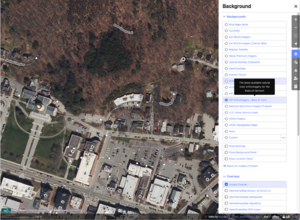
The latest available color orthoimagery from the State of Vermont. - iD Editor: VIP Orthoimagery - Best of Color
- JOSM Editor: VT: VIP Orthoimagery - Best of Color
- Infrared False-color infrared imagery can be useful for contrasting vegetation with other surfaces.
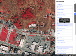
The latest available infrared orthoimagery from the State of Vermont. - iD editor: VIP Orthoimagery - Infrared
- JOSM editor: VT: VIP Orthoimagery - Infrared
- Color
- VT state-wide LIDAR Imagery Captured during the same aerial surveys as the VIP Orthoimagery imagery (above), this imagery is very high resolution (4cm) and exceptionally well aligned. As a rendering of a 3D model it is not warped in slopping terrain, making it the ideal reference for aligning roads, buildings, and other features on the map.
- LiDAR Digital Elevation Model (DEM) hillshade imagery This imagery product uses multi-wavelength capture and post-processing techniques to build an elevation model stripped of buildings and vegetation. The resulting model is then directionally shaded to visualize the terrain. It allows "peering through" vegetation to see road and stream beds, old foundations and stone walls, and other land forms often obscured by trees.
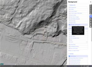
LiDAR Digital Elevation Model (DEM) hillshade imageryLiDAR Digital Elevation Model (DEM) hillshade imagery - iD editor: VCGI LiDAR - DEM Hillshade
- JOSM editor: VT: VCGI LiDAR - DEM Hillshade
- To add as a WTMS URL:
https://maps.vcgi.vermont.gov/arcgis/rest/services/EGC_services/IMG_VCGI_LIDARHILLSHD_WM_CACHE_v1/ImageServer/WMTS/1.0.0/WMTSCapabilities.xml
- LiDAR Digital Surface Model (DSM) hillshade imageryThis product is a shaded rendering of a 3D model generated from LiDAR point clouds captured from aerial surveys. 4cm resolution.
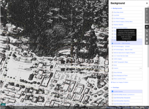
- iD editor: VCGI LiDAR - DSM Hillshade
- JOSM editor: VT: VCGI LiDAR - DSM Hillshade
- To add as a WMS URL:
wms:https://maps.vcgi.vermont.gov/arcgis/services/EGC_services/IMG_VCGI_LIDARDSMHILLSHD_SP_CACHE_v1/ImageServer/WMSServer?FORMAT=image/png&TRANSPARENT=TRUE&VERSION=1.1.1&SERVICE=WMS&REQUEST=GetMap&LAYERS=0&STYLES=&SRS={proj}&WIDTH={width}&HEIGHT={height}&BBOX={bbox}
- LiDAR Digital Elevation Model (DEM) hillshade imagery This imagery product uses multi-wavelength capture and post-processing techniques to build an elevation model stripped of buildings and vegetation. The resulting model is then directionally shaded to visualize the terrain. It allows "peering through" vegetation to see road and stream beds, old foundations and stone walls, and other land forms often obscured by trees.
Usage grant for VCGI data
(Also recorded in Potential Datasources)
Vermont Center for Geographic Information (VGCI) - The Warranty & Copyright notice mentions only that non-value added sale is prohibited:
"4.1 For all products, services, Internet Website, and data the direct, non-value added, reproduction of State of Vermont or VCGI’s products, services, Website, or data with intent to sell and without the written consent of VCGI."
In response to a request for clarification, the following statement was received from John E. Adams AICP, Director of the Vermont Center for Geographic Information. (Adamfranco (talk) 14:52, 21 September 2017 (UTC))
"The State of Vermont Center for Geographic Information has no objections to geodata derived in part from data-sets published by the Vermont Center for Geographic Information in the Vermont Open Geodata Portal being incorporated into the OpenStreetMap project geodata database and released under a free and open license."
Imports
Quirky Vermont things to map
- Map "witch windows" with
windows:diagonal=*. A map of usage can be seen at https://overpass-turbo.eu/s/27Sk - Many towns have a cannon, tank, artillery piece or similar as a memorial on their town greens. These can be mapped with
historic=memorial+memorial=*if they have a dedication/plaque orhistoric=*if they are un-dedicated. A map of usage can be seen at https://overpass-turbo.eu/s/27SF - Creemee & ice cream stands:
ice_cream=*orcuisine=ice_cream. A map of usage can be seen at https://overpass-turbo.eu/s/27SO
Cities
| %age complete | |||||
|---|---|---|---|---|---|
| ZIP | City | Tracks | Mapped | Labelled | Notes |
| Burlington, Vermont | |||||

