Zh-hans:Tag:highway=trunk
Jump to navigation
Jump to search
 |
| 说明 |
|---|
| 非高速公路的重要道路。 |
| 在OSM Carto中渲染 |

|
| 组: 道路 |
| 用于这些元素 |
| 暗含 |
| 常用组合 |
| 另见 |
| 状态:实际使用 |
| 此标签的工具 |
使用highway=trunk标注高品质或重要性高的道路,不过不需要达到motorway的要求。
在不同的国家,道路质量或重要性都是定义trunk的标准。关于不同国家道路分类的指引,请参见#各地案例与Highway:International equivalence。
在中国内地,trunk用于标注国道和城市快速路,如北京三环路、上海中环快速路或101国道(红色矩形标志)等。
在中华民国(台湾),trunk用于标注省道快速公路(红色盾形标志)或市区快速道路,如新北市环河快速道路、省道台61线西滨快速道路等。
如何绘制

要绘制一条干线道路,您只需要画一条线,然后选择属于该类型道路的路径,并标注为highway=trunk。当道路无法双向行驶时,使用oneway=yes标注,并确保路径方向与行驶方向一致,否则请翻转路径方向或使用oneway=-1(建议当路径方向无法翻转时使用)。
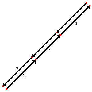
在双向道路的情况下,您应该为每条行车道单独绘制路径,并为不同方向分别标注。将路径节点对齐(如图所示)。这将使地图渲染效果更好,并指明两条路径共为一体。
如需为道路加入更多信息,请进一步添加下列标签:
- name=名称 - 道路名称。例如:“广园快速路”;
- maxspeed=数字 - 道路法定最高限速(公里每小时),例如:“80”;
- minspeed=数字 - 表示行驶道路必须达到的最低限速;
- ref=编制名称 - 道路的编制号码,请参见该国道路的编号系统,例如“G101”;
- loc_name=名称 - 非官方或道路俗称;
- maxweight=数字 - 最大载重限制(吨),例如“49”
- surface=* - 路面材质说明。例如“asphalt”(沥青);
- width=数字 或 est_width=数字 - 道路宽度(米),例如“24.5”;
- lanes=数字 - 道路可用车道数,通常为“2”或“3”;
- motorroad=* 表示该道路仅限机动车通行;
- toll:N3=yes - 最大允许载重,大于12吨的卡车需收取通行费
- destination=* 表示道路通往的目的地。请考虑路径的方向,并使用写在属于trunk_link道路指示标志上的城市名称:例如“北京”(关于trunk_link,请参见highway=motorway_link)
特殊情况
下列是一些特殊的trunk:
- highway=trunk_link - 通往或离开快速道路的联络道路(匝道/渠化路口转向专用道)改用。
- bridge=yes + layer=1 - 快速道路横越街道或水路时附加。
- tunnel=yes + layer=-1 - 快速道路穿越街道或水路下方时附加。
各地案例
下列为各个国家和地区如何使用标签的比较表,用户应该查阅特定国家的指南以了解更多详细讯息及其他标签。
关于不同地区的特别规定与如何标注各国特定标签的列表,请参见Category:Projects。
| 国家和地区 | 使用说明 | 更多详情 |
|---|---|---|
| National highways; state strategic road network. Connecting major population centres. For example Bruce Highway, Pacific Highway. |
Australian Roads Tagging | |
| Autostraße |
WikiProject Austria/Schnellstraßen | |
| Autoweg |
||
| Rodovias duplicadas (divided highways), vias expressas urbanas (urban expressways) | ||
| Скоростен път с поне две ленти във всяка посока. Ограничението на скоростта не трябва да е по-малко от стандартното (50 км/ч за населени места, 90 км/ч извън тях). | ||
| 普通国道/城市快速路 | ||
| Expressways (Brza cesta) and motorroads (cesta za promet motornih vozila) WikiProject Croatia/Ceste | ||
| Silnice pro motorová vozidla: |
||
| Motortrafikvej |
Da:Map Features | |
| Valtatiet/National Highways | Fi:Map Features | |
| Rocade, voie rapide ou voie express. Voie ayant les caractéristiques d'une autoroute. En général, une 2x2 voies avec séparation centrale. Par défaut : lanes="2", maxspeed="110" (sauf périph. Paris: 80) + ref="Nxx" ou "Dxx" + oneway="yes" + lanes="x" (si voies <> 2) |
FR:Map Features | |
| For Motorway Like Roads (Autobahnähnliche Straße collq. Schnellstraße) without crossings. The carriageways are separated physically or by road markings. Motorway-like junctions with exit signs |
DE:Tag:highway=trunk | |
| 1st-tier National Roads | WikiProject Greece § Road Network | |
| 有编号的道路,但不是高速公路或隧道 | Zh-hant:Hong Kong tagging#街道分類 Classifications of streets | |
| Autóút | ||
| National Roads. Different by island. | ||
| The Expressways according to the definition of Iranian National Standardization Organization. | ||
| National Primary Routes, regardless of build quality. Currently numbered N1-N33. Signed in white lettering on a green background. | ||
| National Primary Routes, regardless of build quality. They are numbered with one or two digits. Red numbers on a white background surrounded by green border. |
He:Map Features | |
| "Strade a scorrimento veloci" (~roads for high travel speeds) with on ramps and off ramps and without level crossings or roundabouts, a road class generally between primary roads and motorways. For mapping access restrictions similar to motorways, use the tag motorroad=yes. Usually the major roads between cities are of this type. | ||
| 国道/National Highways | ||
| Rocade, expressway.2x2 Divided highway, every intersections with roundabout.speedlimit 80 or 100 km/h | ||
| Autoweg |
NL:Map Features | |
| Strategic State Highways State Highways linking major urban areas (population 30,000+), major ports, major airports, international tourist destinations, and/or remote regions. Generally two lanes undivided with regular passing lanes. All State Highways not meeting the criteria should be tagged highway=primary. |
||
| Nation infrastructure road (Riksvei) that are not "Motorvei" , green signs, include E-roads class A and B |
No:Map Features#Road classes | |
| Primary national roads connecting major cities and provinces. Examples are the Pan-Philippine Highway/AH26 (not including toll expressway segments, like segments on NLEX and SLEX) that are tagged highway=motorway) , Daang Maharlika, MacArthur Highway, EDSA (includes portions not marked as part of Pan-Philippine Highway/AH26), Aguinaldo Highway, Governor's Drive, Jose P. Laurel Highway (mostly designated as Manila - Batangas Road, but short segment at Santo Tomas is designated as Santo Tomas Bypass Road) , Andaya Highway, Strong Republic Nautical Highway, etc. |
Philippines/Mapping conventions#Roads | |
| WikiProject Poland/Klasyfikacja dróg | ||
| Via Rápida | ||
highway=trunk is used for any national road part of a European corridor or express ways (do not exist in Romania); along with the national road shield (white on red background) E.g.: DN6/E60, DN2/E85 . |
Ro:Map Features#Drumuri | |
| Cesta pre motorové vozidlá: |
||
| Divided highway without ramps. Higher speeds. Few stop lights or stop signs. |
||
| Trunk roads (stamväg) as defined by the state, including all European routes and certain other national roads (riksväg). Exceptionally also shorter stretches of other roads having similar importance locally. | ||
| Autostrasse / autoroute de 2eme classe (semi-autoroute) | ||
| Refers to a (paved) 'Trunk Road', as classified by Tanroads. Main roads that connect major cities in the country: e.g. T1 from Dar es Salaam - Zambia border. | ||
| primary A road (green signs) | ||
| Surface expressway: A relatively high-speed divided road (at least 40 MPH with a barrier or median separating each direction of traffic), with a limited amount of intersections and driveways; or a major intercity highway. This includes many U.S. Highways (that do not parallel an Interstate) and some state highways. | Wikipedia reference | |
| Main roads used for the vast majority of trunks (T-XX, Troncal XX) that run across the country, and that generally connect one city with another. In some places some of the local roads (L-XX, Local XX) will also be included. | ||
| Trunk (Xa lộ) in Vietnam usually have more than 3 lane with lane classification signs. |
示例
| 图像/说明 | 标签 | Mapnik |
|---|---|---|
|
|
(每个方向道路标注为) highway=trunk |

|
| ||||||||||||||||||||||||||||||