OpenStreetMap Carto/Areas
(Redirected from AreasTab)
Areas
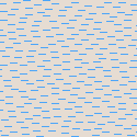
Areas in the Standard tile layer denote various different things, from land usage to buildings to restricted access zones. A few areas may be drawn as a overlay. This means they can be combined with another background. For example, wetland can be combined with forest, grassland, etc.
| Area | Symbol | Description | Overlay? | Wiki page |
|---|---|---|---|---|
Nature | ||||

|
(no symbol) | Land (This is only shown when no more specific information is available) | No | |

|
(no symbol) | Body of water (ocean, sea, pond, river) / swimming pool / artificial basin / artificial lake / water-covered area of a river / dock | No | natural=water / leisure=swimming_pool / landuse=basin / landuse=reservoir / waterway=riverbank / waterway=dock
|

|
(no symbol) | Water body intermittent / Water body seasonal / Infiltration basin / Detention basin | No | natural=water + intermittent=* / natural=water + seasonal=* / landuse=basin + basin=infiltration / landuse=basin + basin=detention
|

|
(no symbol) | Reef | No | natural=reef
|

|
(no symbol) | Natural woodland which is mostly or not at all not used for timber production | Yes | natural=wood
|

|
(no symbol) | Broadleaved woodland | Yes | natural=wood + leaf_type=broadleaved
|

|
(no symbol) | Needleleaved woodland | Yes | natural=wood + leaf_type=needleleaved
|

|
(no symbol) | Mixed woodland | Yes | natural=wood + leaf_type=mixed
|

|
(no symbol) | Leafless vegetation | Yes | natural=wood + leaf_type=leafless
|

|
(no symbol) | Natural grassland | No | natural=grassland
|

|
(no symbol) | Bushes and small trees | No | natural=scrub
|

|
(no symbol) | Dwarf scrubs | No | natural=heath
|

|
(no symbol) | Generic beach / Shoal | No | natural=beach / natural=shoal
|

|
(no symbol) | Generic sand area / golf bunker | No | natural=sand / golf=bunker
|

|
(no symbol) | Beach with sand surface / shoal with sand surface | No | natural=beach + surface=sand / natural=shoal + surface=sand
|

|
(no symbol) | Beach with coarse sand surface / shoal with coarse sand surface | No | natural=beach + surface=gravel / natural=shoal + surface=gravel
|

|
(no symbol) | Bare rock surface | No | natural=bare_rock
|

|
(no symbol) | Scree / Shingle | No | natural=scree / natural=shingle
|

|
(no symbol) | Wetland (generic) | Yes | natural=wetland
|
|
(no symbol) | Mud | No | natural=mud
|
|
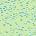
(no symbol) | Marsh / Semi-wetland meadow / Fen | Yes | natural=wetland + wetland=marsh / natural=wetland + wetland=wet_meadow / natural=wetland + wetland=fen
|
|
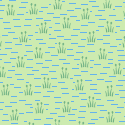
(no symbol) | Reedbed | Yes | natural=wetland + wetland=reedbed
|
|
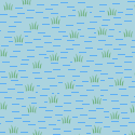
(no symbol) | Salt marsh | Yes | natural=wetland + wetland=saltmarsh
|

|
(no symbol) | Swamp | Yes | natural=wetland + wetland=swamp
|
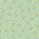
|
(no symbol) | Mangrove | Yes | natural=wetland + wetland=mangrove
|
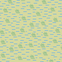
|
(no symbol) | Bog / String bog | Yes | natural=wetland + wetland=bog / natural=wetland + wetland=string_bog
|

|
(no symbol) | Tidalflat, Mudflat | Yes | natural=wetland + wetland=tidalflat
|

|
(no symbol) | Salt pond | Yes | landuse=salt_pond
|

|
(no symbol) | Glacier | No | natural=glacier
|
City planning | ||||

|
(no symbol) | Residential area | No | landuse=residential
|

|
(no symbol) | Commercial area or business park (predominantly offices) | No | landuse=commercial
|

|
(no symbol) | Retail area (predominantly shops) / Shopping mall | No | landuse=retail / shop=mall
|

|
A marketplace where trade is regulated | No | amenity=marketplace
| |

|
(no symbol) | Industrial area / Area for railway usage / Waterworks / Wastewater plant | No | landuse=industrial / landuse=railway / man_made=water_works / man_made=wastewater_plant
|

|
Railway station | No | railway=station
| |

|
(no symbol) | Garages area | No | landuse=garages
|

|
(no symbol) | Christian cemetery / Christian grave yard | No | landuse=cemetery + religion=christian / amenity=grave_yard + religion=christian
|

|
(no symbol) | Jewish cemetery / Jewish grave yard | No | landuse=cemetery + religion=jewish / amenity=grave_yard + religion=jewish
|

|
(no symbol) | Muslim cemetery / Muslim grave yard | No | landuse=cemetery + religion=muslim / amenity=grave_yard + religion=muslim
|

|
(no symbol) | Cemetery with unknown, other or no specific religious background / Grave yard with unknown, other or no specific religious background | No | landuse=cemetery / amenity=grave_yard
|

|
(no symbol) | Brownfield / Construction yard | No | landuse=brownfield / landuse=construction
|

|
(no symbol) | Landfill | No | landuse=landfill
|
Buildings | ||||

|
(no symbol) | Non-specific building | No | building=*
|

|
(no symbol) | Airport terminal / Train station / Aerialway station / Bus station | No | aeroway=terminal + building=* / building=train_station / aerialway=station + building=* / public_transport=station + building=*
|

|
Place of worship where religious practices are held, i.e. church, synagogue, mosque, temple. | No | amenity=place_of_worship + building=*
| |
Transportation | ||||

|
Car parking lot Bicycle parking Motorcycle parking Taxi rank |
No | amenity=parking amenity=bicycle_parking amenity=motorcycle_parking amenity=taxi
| |

|
Airport Ferry terminal Bus station |
No | aeroway=aerodrome amenity=ferry_terminal amenity=bus_station
| |

|
(no symbol) | Place where drivers can leave a road to refuel, rest, or take refreshments / Place where drivers can leave the road to rest, but not refuel | No | highway=services / highway=rest_area
|

|
(no symbol) | Platform at a bus stop or station / Railway platform | No | highway=platform / railway=platform
|

|
(no symbol) | Bridge | No | man_made=bridge
|

|
(no symbol) | Runway / taxiway | No | aeroway=runway / aeroway=taxiway
|

|
helipad | No | aeroway=helipad
| |

|
(no symbol) | Apron | No | aeroway=apron
|

|
(no symbol) | Service highway as a freely routable area | No | highway=service + area=yes
|

|
(no symbol) | Living street as an freely routable area | No | highway=living_street + area=yes
|

|
(no symbol) | Pedestrian street or footway as a freely routable area | No | highway=pedestrian + area=yes / highway=footway + area=yes
|
Agriculture and industry | ||||

|
(no symbol) | Farmland / Land area used for growing plants in greenhouses | No | landuse=farmland / landuse=greenhouse_horticulture
|

|
(no symbol) | Farmyard | No | landuse=farmyard
|

|
(no symbol) | Allotments | No | landuse=allotments
|

|
(no symbol) | Orchard | No | landuse=orchard
|

|
(no symbol) | Plant nursery | No | landuse=plant_nursery
|

|
(no symbol) | Garden | No | leisure=garden
|

|
(no symbol) | Managed forest | No | landuse=forest
|

|
(no symbol) | Broadleaved woodland | No | landuse=forest + leaf_type=broadleaved
|

|
(no symbol) | Needleleaved woodland | No | landuse=forest + leaf_type=needleleaved
|

|
(no symbol) | Mixed woodland | No | landuse=forest + leaf_type=mixed
|

|
(no symbol) | Leafless vegetation | No | landuse=forest + leaf_type=leafless
|

|
(no symbol) | Vineyard | No | landuse=vineyard
|

|
(no symbol) | Quarry | No | landuse=quarry
|

|
(no symbol) | Dam | No | waterway=dam
|

|
(no symbol) | Breakwater / Groyne | No | man_made=breakwater + area=yes / man_made=groyne + area=yes
|
Electricity | ||||

|
(no symbol) | Generator / Substation / Plant | No | power=generator / power=substation / power=plant
|
Leisure and recreation | ||||

|
(no symbol) | Park | No | leisure=park
|

|
(no symbol) | Recreation ground | No | landuse=recreation_ground
|

|
Playground Fitness station |
No | leisure=playground leisure=fitness_station
| |

|
(no symbol) | (managed) Grassland / (managed) Meadow / Village green / Teeing ground of a golf course / Fairway of a golf course / Driving range of a golf course | No | landuse=grass / landuse=meadow / landuse=village_green / golf=tee / golf=fairway / golf=driving_range
|

|
Campsite Caravansite |
No | tourism=camp_site tourism=caravan_site
| |

|
Dog park | No | leisure=dog_park
| |

|
(no symbol) | Flowerbed | No | landuse=flowerbed
|
Sports | ||||

|
(no symbol) | Sports centre / Stadium | No | leisure=sports_centre / leisure=stadium
|

|
(no symbol) | Sports pitch (i.e. soccer field, basketball field, etc.) / Running track | No | leisure=pitch / leisure=track
|

|
(no symbol) | A place where you can skate and play bandy or ice hockey | No | leisure=ice_rink
|

|
Golf course Miniature golf course |
No | leisure=golf_course leisure=miniature_golf
| |

|
(no symbol) | Golf rough | No | golf=rough
|

|
(no symbol) | Putting green of a golf course | No | golf=green
|
Institutional areas | ||||

|
(no symbol) | Area which belongs to a kindergarten / school / college / university | No | amenity=kindergarten / amenity=school / amenity=college / amenity=university
|

|
Area which belongs to a community centre social facility arts centre |
No | amenity=community_centre amenity=social_facility amenity=arts_centre
| |

|
Area which belongs to a hospital | No | amenity=hospital
| |

|
Area which belongs to a clinic | No | amenity=clinic
| |

|
Police station Fire station |
No | amenity=police amenity=fire_station
| |

|
Prison ground | Yes | amenity=prison
| |

|
(no symbol) | Religious ground | No | landuse=religious
|

|
Place of worship where religious practices are held (other than building). | No | amenity=place_of_worship
| |
Military | ||||

|
(no symbol) | Land used by the military. | Yes | landuse=military
|

|
(no symbol) | A military zone which has been be declared to be dangerous for some reason (i.e. a firing range, bombing range, etc.). | Yes | military=danger_area
|
Miscellaneous - framed areas | ||||
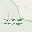
|
(no symbol) | National park / Nature reserve | Yes | boundary=national_park / leisure=nature_reserve
|

|
(no symbol) | Aboriginal Lands | Yes | boundary=aboriginal_lands
|

|
(no symbol) | Zoo | Yes | tourism=zoo
|
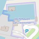
|
(no symbol) | Marina | Yes | leisure=marina
|

|
(no symbol) | Theme park, Amusement park, Discovery park, Open-air museum, Miniature park | Yes | tourism=theme_park
|

|
(no symbol) | A factory or industrial production plant | Yes | man_made=works
|

|
(no symbol) | single parking space on a parking lot | Yes | amenity=parking_space
|
See also
- Standard tile layer (OSM Carto)
External links
| ||||||||||||||||||||||||||